The G12 postcode district is a postal district located in the G Glasgow postcode area with a population of 24,177 residents according to the 2011 Scotland Census.
The area of the G12 postcode district is 1.49 square miles which is 3.87 square kilometres or 955.52 acres.
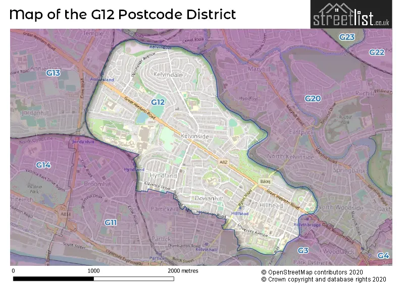
Currently, the G12 district has about 659 postcode units spread across 3 geographic postcode sectors.
Given that each sector allows for 400 unique postcode combinations, the district has a capacity of 1,200 postcodes. With 659 postcodes already in use, this leaves 541 units available.
The G12 postal code covers the settlement of GLASGOW.
The G12 Postcode shares a border with G13 (GLASGOW), G11 (GLASGOW), G20 (GLASGOW) and G4 (GLASGOW).
In the G12 postcode district in Glasgow, the primary settlement is Glasgow, which is located in the City of Glasgow. Glasgow has the highest count of postcodes in this district. There are also significant settlements within the G12 postcode district, including settlements in the City of Glasgow.
For the district G12, we have data on 3 postcode sectors. Here's a breakdown: The sector G12 0, covers Glasgow in City of Glasgow. The sector G12 8, covers Glasgow in City of Glasgow. The sector G12 9, covers Glasgow in City of Glasgow.


Map of the G12 Postcode District
Explore the G12 postcode district by using our free interactive map.
When it comes to local government, postal geography often disregards political borders. However, for a breakdown in the G12 District: the district mostly encompasses the Glasgow City area with a total of 659 postcodes.
Where is the G12 Postcode District?
The data shows that the G12 postcode district is located in Glasgow, which is a district town. It is situated near other towns such as Dunfermline to the North East, Ayr to the South East, Clydebank to the North West, and Edinburgh to the South. The distance from the G12 postcode district to the center of London is approximately 347.47 miles.
The district is within the post town of GLASGOW.
The sector has postcodes within the nation of Scotland.
The G12 Postcode District is in the Glasgow City region of West Central Scotland within the Scotland.
Weather Forecast for G12
Press Button to Show Forecast for Kelvinside
| Time Period | Icon | Description | Temperature | Rain Probability | Wind |
|---|---|---|---|---|---|
| 18:00 to 21:00 | Thunder shower (day) | 19.0°C (feels like 18.0°C) | 63.00% | SE 9 mph | |
| 21:00 to 00:00 | Heavy rain shower (night) | 16.0°C (feels like 16.0°C) | 54.00% | ESE 4 mph |
Press Button to Show Forecast for Kelvinside
| Time Period | Icon | Description | Temperature | Rain Probability | Wind |
|---|---|---|---|---|---|
| 00:00 to 03:00 | Light rain shower (night) | 15.0°C (feels like 14.0°C) | 32.00% | E 7 mph | |
| 03:00 to 06:00 | Light rain shower (night) | 13.0°C (feels like 12.0°C) | 29.00% | ENE 7 mph | |
| 06:00 to 09:00 | Overcast | 13.0°C (feels like 12.0°C) | 11.00% | ENE 9 mph | |
| 09:00 to 12:00 | Overcast | 15.0°C (feels like 14.0°C) | 18.00% | ENE 9 mph | |
| 12:00 to 15:00 | Light rain shower (day) | 18.0°C (feels like 16.0°C) | 35.00% | ENE 11 mph | |
| 15:00 to 18:00 | Light rain shower (day) | 19.0°C (feels like 17.0°C) | 38.00% | E 11 mph | |
| 18:00 to 21:00 | Light rain shower (day) | 17.0°C (feels like 16.0°C) | 35.00% | E 7 mph | |
| 21:00 to 00:00 | Cloudy | 15.0°C (feels like 14.0°C) | 10.00% | ENE 7 mph |
Press Button to Show Forecast for Kelvinside
| Time Period | Icon | Description | Temperature | Rain Probability | Wind |
|---|---|---|---|---|---|
| 00:00 to 03:00 | Cloudy | 13.0°C (feels like 12.0°C) | 13.00% | ENE 7 mph | |
| 03:00 to 06:00 | Cloudy | 13.0°C (feels like 12.0°C) | 18.00% | ENE 7 mph | |
| 06:00 to 09:00 | Light rain | 13.0°C (feels like 11.0°C) | 45.00% | ENE 7 mph | |
| 09:00 to 12:00 | Light rain | 14.0°C (feels like 13.0°C) | 49.00% | ENE 9 mph | |
| 12:00 to 15:00 | Light rain | 17.0°C (feels like 15.0°C) | 47.00% | E 11 mph | |
| 15:00 to 18:00 | Light rain shower (day) | 17.0°C (feels like 15.0°C) | 42.00% | ENE 11 mph | |
| 18:00 to 21:00 | Light rain | 15.0°C (feels like 13.0°C) | 55.00% | ENE 11 mph | |
| 21:00 to 00:00 | Light rain | 13.0°C (feels like 11.0°C) | 47.00% | ENE 9 mph |
Press Button to Show Forecast for Kelvinside
| Time Period | Icon | Description | Temperature | Rain Probability | Wind |
|---|---|---|---|---|---|
| 00:00 to 03:00 | Overcast | 12.0°C (feels like 11.0°C) | 17.00% | ENE 9 mph | |
| 03:00 to 06:00 | Overcast | 12.0°C (feels like 11.0°C) | 18.00% | ENE 7 mph | |
| 06:00 to 09:00 | Overcast | 12.0°C (feels like 11.0°C) | 15.00% | ENE 7 mph | |
| 09:00 to 12:00 | Overcast | 15.0°C (feels like 14.0°C) | 11.00% | E 7 mph | |
| 12:00 to 15:00 | Light rain shower (day) | 18.0°C (feels like 17.0°C) | 27.00% | E 7 mph | |
| 15:00 to 18:00 | Light rain shower (day) | 18.0°C (feels like 17.0°C) | 31.00% | ESE 9 mph | |
| 18:00 to 21:00 | Light rain shower (day) | 17.0°C (feels like 16.0°C) | 33.00% | E 9 mph | |
| 21:00 to 00:00 | Partly cloudy (night) | 14.0°C (feels like 13.0°C) | 7.00% | E 7 mph |
Press Button to Show Forecast for Kelvinside
| Time Period | Icon | Description | Temperature | Rain Probability | Wind |
|---|---|---|---|---|---|
| 00:00 to 03:00 | Cloudy | 12.0°C (feels like 11.0°C) | 8.00% | ENE 7 mph | |
| 03:00 to 06:00 | Overcast | 11.0°C (feels like 10.0°C) | 11.00% | ENE 4 mph | |
| 06:00 to 09:00 | Overcast | 12.0°C (feels like 11.0°C) | 13.00% | ENE 4 mph | |
| 09:00 to 12:00 | Overcast | 14.0°C (feels like 13.0°C) | 12.00% | E 4 mph | |
| 12:00 to 15:00 | Partly cloudy (day) | 17.0°C (feels like 16.0°C) | 11.00% | SE 7 mph | |
| 15:00 to 18:00 | Cloudy | 19.0°C (feels like 18.0°C) | 17.00% | SSE 7 mph | |
| 18:00 to 21:00 | Cloudy | 17.0°C (feels like 16.0°C) | 13.00% | ESE 7 mph | |
| 21:00 to 00:00 | Cloudy | 13.0°C (feels like 12.0°C) | 7.00% | ESE 7 mph |
| Postcode Sector | Delivery Office |
|---|---|
| G12 0 | Glasgow G11/12 Delivery Office |
| G12 8 | Glasgow G11/12 Delivery Office |
| G12 9 | Glasgow G11/12 Delivery Office |
| G | 1 | 2 | - | X | X | X |
| G | 1 | 2 | Space | Numeric | Letter | Letter |
Current Monthly Rental Prices
| # Bedrooms | Min Price | Max Price | Avg Price |
|---|---|---|---|
| £950 | £950 | £950 | |
| 1 | £775 | £1,495 | £1,020 |
| 2 | £795 | £2,595 | £1,728 |
| 3 | £1,400 | £3,250 | £2,263 |
| 4 | £2,800 | £3,295 | £3,024 |
| 5 | £3,500 | £3,500 | £3,500 |
| 6 | £3,060 | £3,060 | £3,060 |
| 8 | £5,000 | £5,600 | £5,300 |
Current House Prices
| # Bedrooms | Min Price | Max Price | Avg Price |
|---|---|---|---|
| 1 | £109,000 | £255,000 | £176,700 |
| 2 | £165,000 | £630,000 | £282,083 |
| 3 | £130,000 | £675,000 | £367,739 |
| 4 | £420,000 | £420,000 | £420,000 |
| 5 | £319,000 | £735,000 | £509,667 |
Estate Agents who Operate in the G12 District
| Logo | Name | Brand Name | Address | Contact Number | Total Properties |
|---|---|---|---|---|---|
 | Glasgow | TAY LETTING | 8 Eagle Street, Glasgow, G4 9XA | 0141 673 4267 | 18 |
 | Westend | Clyde Property | 145 Byres Road Westend Glasgow, G12 8TT | 0141 673 3491 | 13 |
 | West End | Rettie & Co | 115 Byres Road, Glasgow, G11 5HW | 0141 673 0713 | 12 |
 | West End | Corum | 82 Hyndland Road, Glasgow, G12 9UT | 0141 673 4501 | 9 |
 | Glasgow | Ivy Property | 81 Lauderdale Gardens, Glasgow, G12 9QU | 0141 673 7555 | 6 |