The G45 postcode district is a postal district located in the G Glasgow postcode area with a population of 14,821 residents according to the 2011 Scotland Census.
The area of the G45 postcode district is 2.49 square miles which is 6.46 square kilometres or 1,596.68 acres.
Currently, the G45 district has about 299 postcode units spread across 2 geographic postcode sectors.
Given that each sector allows for 400 unique postcode combinations, the district has a capacity of 800 postcodes. With 299 postcodes already in use, this leaves 501 units available.
The G45 postal code covers the settlement of GLASGOW.
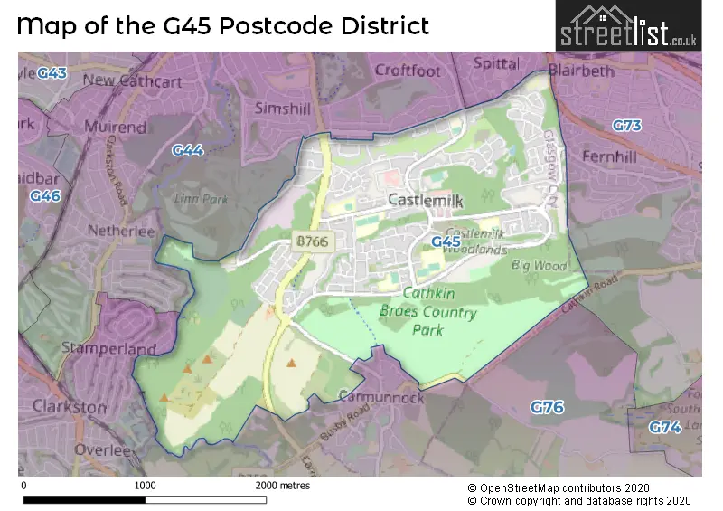
The G45 Postcode shares a border with G76 (Clarkston, Eaglesham), G73 (Rutherglen) and G44 (GLASGOW).
The primary settlement in the G45 postcode district is Glasgow, which is located in the City of Glasgow in Scotland. Additionally, there is another significant settlement in the district, also named Glasgow. Both settlements fall within the same post town and county.
For the district G45, we have data on 3 postcode sectors. Here's a breakdown: The sector G45 0, covers Glasgow in City of Glasgow. The sector G45 5 is non-geographic. It's often designated for PO Boxes, large organisations, or special services. The sector G45 9, covers Glasgow in City of Glasgow.

Map of the G45 Postcode District
Explore the G45 postcode district by using our free interactive map.
When it comes to local government, postal geography often disregards political borders. However, for a breakdown in the G45 District: the district mostly encompasses the Glasgow City area with a total of 307 postcodes.
Where is the G45 Postcode District?
The data's postcode district, G45, is located in GLASGOW. It is near several towns: ALLOA is to the North, ABERDEEN is to the West, ST. ANDREWS is to the North West, BONNYRIGG is to the South, IRVINE is to the North East, and INVERURIE is to the East. The distance from G45 to London, the center of GLASGOW, is approximately 341.28 miles.
The district is within the post town of GLASGOW.
The sector has postcodes within the nation of Scotland.
The G45 Postcode District is in the Glasgow City region of West Central Scotland within the Scotland.
Weather Forecast for G45
Press Button to Show Forecast for Castlemilk
| Time Period | Icon | Description | Temperature | Rain Probability | Wind |
|---|---|---|---|---|---|
| 00:00 to 03:00 | Overcast | 10.0°C (feels like 10.0°C) | 9.00% | ESE 2 mph | |
| 03:00 to 06:00 | Cloudy | 10.0°C (feels like 10.0°C) | 5.00% | E 2 mph | |
| 06:00 to 09:00 | Overcast | 11.0°C (feels like 11.0°C) | 8.00% | S 2 mph | |
| 09:00 to 12:00 | Cloudy | 13.0°C (feels like 12.0°C) | 5.00% | WSW 7 mph | |
| 12:00 to 15:00 | Cloudy | 15.0°C (feels like 14.0°C) | 5.00% | SW 9 mph | |
| 15:00 to 18:00 | Cloudy | 16.0°C (feels like 14.0°C) | 4.00% | SW 11 mph | |
| 18:00 to 21:00 | Cloudy | 15.0°C (feels like 14.0°C) | 9.00% | SW 9 mph | |
| 21:00 to 00:00 | Cloudy | 13.0°C (feels like 12.0°C) | 11.00% | SW 9 mph |
Press Button to Show Forecast for Castlemilk
| Time Period | Icon | Description | Temperature | Rain Probability | Wind |
|---|---|---|---|---|---|
| 00:00 to 03:00 | Cloudy | 12.0°C (feels like 11.0°C) | 19.00% | SW 7 mph | |
| 03:00 to 06:00 | Cloudy | 12.0°C (feels like 10.0°C) | 24.00% | SW 7 mph | |
| 06:00 to 09:00 | Cloudy | 12.0°C (feels like 11.0°C) | 20.00% | SW 7 mph | |
| 09:00 to 12:00 | Cloudy | 14.0°C (feels like 13.0°C) | 13.00% | WSW 9 mph | |
| 12:00 to 15:00 | Cloudy | 16.0°C (feels like 15.0°C) | 7.00% | WSW 9 mph | |
| 15:00 to 18:00 | Cloudy | 17.0°C (feels like 15.0°C) | 8.00% | WSW 9 mph | |
| 18:00 to 21:00 | Cloudy | 16.0°C (feels like 15.0°C) | 5.00% | WSW 7 mph | |
| 21:00 to 00:00 | Cloudy | 13.0°C (feels like 13.0°C) | 6.00% | SW 4 mph |
Press Button to Show Forecast for Castlemilk
| Time Period | Icon | Description | Temperature | Rain Probability | Wind |
|---|---|---|---|---|---|
| 00:00 to 03:00 | Cloudy | 12.0°C (feels like 12.0°C) | 7.00% | SSW 2 mph | |
| 03:00 to 06:00 | Cloudy | 11.0°C (feels like 10.0°C) | 8.00% | SSE 2 mph | |
| 06:00 to 09:00 | Cloudy | 12.0°C (feels like 12.0°C) | 8.00% | SSE 2 mph | |
| 09:00 to 12:00 | Cloudy | 16.0°C (feels like 15.0°C) | 6.00% | S 4 mph | |
| 12:00 to 15:00 | Cloudy | 18.0°C (feels like 17.0°C) | 6.00% | SSW 7 mph | |
| 15:00 to 18:00 | Cloudy | 19.0°C (feels like 17.0°C) | 7.00% | SW 7 mph | |
| 18:00 to 21:00 | Cloudy | 18.0°C (feels like 17.0°C) | 6.00% | SSW 7 mph | |
| 21:00 to 00:00 | Partly cloudy (night) | 14.0°C (feels like 13.0°C) | 1.00% | S 4 mph |
Press Button to Show Forecast for Castlemilk
| Time Period | Icon | Description | Temperature | Rain Probability | Wind |
|---|---|---|---|---|---|
| 00:00 to 03:00 | Cloudy | 12.0°C (feels like 12.0°C) | 4.00% | S 4 mph | |
| 03:00 to 06:00 | Cloudy | 11.0°C (feels like 11.0°C) | 5.00% | SSE 4 mph | |
| 06:00 to 09:00 | Cloudy | 13.0°C (feels like 12.0°C) | 6.00% | SSE 4 mph | |
| 09:00 to 12:00 | Cloudy | 17.0°C (feels like 16.0°C) | 7.00% | S 7 mph | |
| 12:00 to 15:00 | Cloudy | 19.0°C (feels like 17.0°C) | 6.00% | SSW 9 mph | |
| 15:00 to 18:00 | Cloudy | 20.0°C (feels like 18.0°C) | 10.00% | SSW 9 mph | |
| 18:00 to 21:00 | Cloudy | 18.0°C (feels like 17.0°C) | 7.00% | S 7 mph | |
| 21:00 to 00:00 | Cloudy | 14.0°C (feels like 13.0°C) | 7.00% | S 7 mph |
| Postcode Sector | Delivery Office |
|---|---|
| G45 0 | Glasgow G45 Delivery Office |
| G45 9 | Glasgow G45 Delivery Office |
| G | 4 | 5 | - | X | X | X |
| G | 4 | 5 | Space | Numeric | Letter | Letter |
Current Monthly Rental Prices
| # Bedrooms | Min Price | Max Price | Avg Price |
|---|---|---|---|
| 2 | £825 | £950 | £888 |
Current House Prices
| # Bedrooms | Min Price | Max Price | Avg Price |
|---|---|---|---|
| 2 | £59,000 | £59,000 | £59,000 |
| 3 | £160,000 | £210,000 | £185,000 |
| 4 | £265,000 | £265,000 | £265,000 |
Estate Agents who Operate in the G45 District
| Logo | Name | Brand Name | Address | Contact Number | Total Properties |
|---|---|---|---|---|---|
 | covering Glasgow | Purplebricks | Suite 7 First Floor Cranmore Drive Shirley Solihull B90 4RZ | 020 3910 6765 | 2 |
 | Glasgow | Maclay Property Ltd | 126 West Regent Street, Glasgow, G2 2RQ | 0141 673 5725 | 1 |
 | Paisley | Auction House Scotland | Auction House Scotland Office 2 Craigs Business Centre Macdowall Street Paisley Renfrewshire PA3 2NB | 0141 673 7275 | 1 |
 | Covering Scotland | MQ Estate Agents and Lettings | 148/150 West Regent Street, Glasgow, G2 2RQ | 0141 673 0909 | 1 |
 | Shawlands | Pacitti Jones | 206 Kilmarnock Road, Glasgow, G43 1TY | 0141 673 5777 | 1 |