
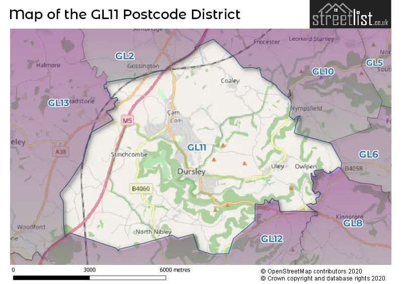
Map of the Postcode District
Explore the postcode district by using our interactive map.
Circles represent recorded crime; the larger the circle, the higher the crime rates.
Your support helps keep this site running!
If you enjoy using this website, consider buying me a coffee to help cover hosting costs.
The postcode district located in the GL Gloucester postal area , GL11 has a population of 19,337 residents according to the 2021 England and Wales Census.
The area of the district is 22.06 square miles (57.15 square kilometers or 14,121.04 acres).
Where is the GL11 District?
To give you an idea where the district is located we have created the following table showing nearby towns.
Nearest Towns to GL11
| Town | Distance (miles) | Direction |
|---|---|---|
| Wotton-under-Edge | 3.36 | S |
| Stonehouse | 5.16 | NE |
| Nailsworth | 5.80 | E |
| Stroud | 7.15 | NE |
| Minchinhampton | 7.36 | E |
| Lydney | 8.08 | WNW |
| Tetbury | 9.06 | ESE |
| Thornbury | 9.08 | SW |
| Painswick | 9.72 | NE |
| Chipping Sodbury | 10.37 | S |
| Yate | 10.44 | SSW |
| Cinderford | 11.39 | NNW |
| Malmesbury | 12.92 | ESE |
| Gloucester | 13.17 | NNE |
| Bradley Stoke | 13.37 | SW |
| Coleford | 13.49 | WNW |
| Mitcheldean | 13.62 | NNW |
| Chepstow | 14.20 | WSW |
| Filton | 15.35 | SW |
Post towns for this district are DURSLEY, WOTTON-UNDER-EDGE.
Postcode Information for District GL11 (Total Geographical Postcodes: 779)
| Location | Post Town | Sector | Number of Postcodes |
|---|---|---|---|
| DURSLEY | DURSLEY | GL11 4 | 201 |
| Cam | DURSLEY | GL11 5 | 162 |
| DURSLEY | DURSLEY | GL11 6 | 99 |
| DURSLEY | DURSLEY | GL11 5 | 54 |
| Norman Hill | DURSLEY | GL11 5 | 44 |
| Tilsdown | DURSLEY | GL11 5 | 42 |
| Uley | DURSLEY | GL11 5 | 40 |
| North Nibley | DURSLEY | GL11 6 | 32 |
| Coaley | DURSLEY | GL11 5 | 30 |
| Woodmancote | DURSLEY | GL11 4 | 24 |
| Stinchcombe | DURSLEY | GL11 6 | 18 |
| Sandpits | DURSLEY | GL11 6 | 8 |
| Woodmancote | DURSLEY | GL11 6 | 4 |
| Stancombe | DURSLEY | GL11 6 | 4 |
| Woodfield | DURSLEY | GL11 6 | 4 |
| Upper Wick | DURSLEY | GL11 6 | 3 |
| Owlpen | DURSLEY | GL11 5 | 3 |
| Ashmead Green | DURSLEY | GL11 5 | 3 |
| Bull Pitch | DURSLEY | GL11 4 | 2 |
| Wick | DURSLEY | GL11 6 | 2 |
Retail and Shopping in GL11
Street
Town
Locality
Number of Shops
Central Postcode
View on Google Maps
PARSONAGE STREET
DURSLEY
43
GL11 4BP
View on Google Maps
SILVER STREET
DURSLEY
23
GL11 4ND
View on Google Maps
LONG STREET
DURSLEY
13
GL11 4HR
View on Google Maps
HIGH STREET
DURSLEY
CAM
9
GL11 5LE
View on Google Maps
KINGSHILL ROAD
DURSLEY
6
GL11 4EJ
View on Google Maps
| Street | Town | Locality | Number of Shops | Central Postcode | View on Google Maps |
|---|---|---|---|---|---|
| PARSONAGE STREET | DURSLEY | 43 | GL11 4BP | View on Google Maps | |
| SILVER STREET | DURSLEY | 23 | GL11 4ND | View on Google Maps | |
| LONG STREET | DURSLEY | 13 | GL11 4HR | View on Google Maps | |
| HIGH STREET | DURSLEY | CAM | 9 | GL11 5LE | View on Google Maps |
| KINGSHILL ROAD | DURSLEY | 6 | GL11 4EJ | View on Google Maps |
In the GL11 postcode district in Gloucestershire, the primary settlement is Dursley, which has the highest count of 168. Other significant settlements in the district include Bull Pitch, Woodmancote, Ashmead Green, Cam, Coaley, Norman Hill, Owlpen, Tilsdown, Uley, North Nibley, Sandpits, Stancombe, Stinchcombe, Upper Wick, Wick, Woodfield. The most significant post town is Dursley. The GL11 postcode district is located in Gloucestershire county within England.
When it comes to local government, postal geography often disregards political borders. However, this district intersects the following councils: the district mostly encompasses the Stroud District area with a total of 618 postal codes.
The largest settlement in the GL11 postal code is DURSLEY followed by Cam, and Uley.
The GL11 Postcode shares a border with GL6 (Nailsworth, Minchinhampton, Chalford), GL8 (TETBURY, Avening, Westonbirt), GL10 (STONEHOUSE, Great Oldbury, Kings Stanley), GL12 (WOTTON-UNDER-EDGE, Charfield, Wickwar), GL13 (BERKELEY, Newtown, Stone) and GL2 (Quedgeley, GLOUCESTER, Hardwicke).


Schools in the Sector
Rednock School
Phase: Secondary
Address: Kingshill Road , Dursley
Postcode: GL11 4BY
Headteacher: Mr Mike Stratford (Headteacher)
Ofsted Rating: Good
Dursley Church of England Primary Academy
Phase: Primary
Address: School Road , Dursley
Postcode: GL11 4NZ
Headteacher: Toni Holford-Wright (Principal)
Ofsted Rating: Good
Coaley Church of England Primary School
Phase: Primary
Address: The Street , Coaley , Dursley
Postcode: GL11 5EB
Headteacher: Mrs Suzette Kearns (Headteacher)
Ofsted Rating: Special Measures
Coaley Church of England Primary Academy
Phase: Primary
Address: The Street , Coaley , Dursley
Postcode: GL11 5EB
Headteacher: Miss Jen Thomas ()
Ofsted Rating: Good
Greenfield Academy
Phase: Not applicable
Address: Drake Lane , Dursley
Postcode: GL11 5HD
Headteacher: Mr Richard Lewis (Principal)
Ofsted Rating: Good
Peak Academy
Phase: Not applicable
Address: Drake Lane , Barton , Dursley
Postcode: GL11 5HD
Headteacher: Mr Mike Thomas (Principal)
Ofsted Rating: Serious Weaknesses
Cam Hopton Church of England Primary School
Phase: Primary
Address: Hopton Road , Upper Cam , Dursley
Postcode: GL11 5PA
Headteacher: Mrs Rebecca Harris (Head Teacher)
Ofsted Rating: Good
Cam Everlands Primary School
Phase: Primary
Address: Birch Road , Cam , Dursley
Postcode: GL11 5SF
Headteacher: Mr Dominic Knill (Headteacher)
Ofsted Rating: Good
Uley Church of England Primary School
Phase: Primary
Address: Woodstock Terrace , Uley , Dursley
Postcode: GL11 5SW
Headteacher: Mrs Zoe Mandeville (Headteacher)
Ofsted Rating: Good
North Nibley CofE Primary School
Phase: Primary
Address: The Street , North Nibley , North Nibley C of E Primary School , Wotton-Under-Edge
Postcode: GL11 6DL
Headteacher: Mr Steven Hodgkinson (Headteacher)
Ofsted Rating: Good
Cam Woodfield Infant School
Phase: Primary
Address: Elstub Lane , Cam , Dursley
Postcode: GL11 6JJ
Headteacher: Mrs Helen Harper (Headteacher)
Ofsted Rating: Good
Cam Woodfield Junior School
Phase: Primary
Address: Elstub Lane , Cam , Dursley
Postcode: GL11 6JJ
Headteacher: Mrs Louise Bennett (Headteacher)
Ofsted Rating: Special Measures
Cam Woodfield Junior School
Phase: Primary
Address: Elstub Lane , Cam , Dursley
Postcode: GL11 6JJ
Headteacher: Mrs Louise Bennett ()
Ofsted Rating: Good
Stations in the Sector
Cam & Dursley
CRS Code: CDU
Operator: GW
Line: Bristol to Brimingham Line
Company: Great Western Railway
Accessable Motorway Junctions
M5 J13
Average Driving Time from within the district: 10.33
Average Driving Distance: 6.87
Number of Postcodes that can access the Motorway Junction: 616
M5 J14
Average Driving Time from within the district: 12.39
Average Driving Distance: 8.29
Number of Postcodes that can access the Motorway Junction: 616
M5 J12
Average Driving Time from within the district: 13.11
Average Driving Distance: 9.75
Number of Postcodes that can access the Motorway Junction: 610
M4 J20
Average Driving Time from within the district: 15.60
Average Driving Distance: 12.59
Number of Postcodes that can access the Motorway Junction: 11
M5 J11A
Average Driving Time from within the district: 19.28
Average Driving Distance: 16.14
Number of Postcodes that can access the Motorway Junction: 100
M5 J15
Average Driving Time from within the district: 19.91
Average Driving Distance: 15.76
Number of Postcodes that can access the Motorway Junction: 209
M5 J11
Average Driving Time from within the district: 21.63
Average Driving Distance: 17.36
Number of Postcodes that can access the Motorway Junction: 8
M48 J1
Average Driving Time from within the district: 22.68
Average Driving Distance: 19.63
Number of Postcodes that can access the Motorway Junction: 286
M4 J18
Average Driving Time from within the district: 22.74
Average Driving Distance: 16.74
Number of Postcodes that can access the Motorway Junction: 173
Weather Forecast for Dursley
| Time Period | Icon | Description | Temperature | Rain Probability | Wind |
|---|---|---|---|---|---|
| 12:00 to 15:00 | Light rain shower (day) | 14.0°C (feels like 12.0°C) | 33.00% | WSW 9 mph | |
| 15:00 to 18:00 | Partly cloudy (day) | 15.0°C (feels like 13.0°C) | 3.00% | WSW 9 mph | |
| 18:00 to 21:00 | Clear night | 12.0°C (feels like 11.0°C) | 0.00% | SW 7 mph | |
| 21:00 to 00:00 | Clear night | 11.0°C (feels like 10.0°C) | 0.00% | S 7 mph |
| Time Period | Icon | Description | Temperature | Rain Probability | Wind |
|---|---|---|---|---|---|
| 00:00 to 03:00 | Clear night | 10.0°C (feels like 9.0°C) | 1.00% | S 7 mph | |
| 03:00 to 06:00 | Partly cloudy (night) | 10.0°C (feels like 9.0°C) | 1.00% | S 7 mph | |
| 06:00 to 09:00 | Mist | 10.0°C (feels like 9.0°C) | 12.00% | S 7 mph | |
| 09:00 to 12:00 | Mist | 11.0°C (feels like 10.0°C) | 12.00% | S 9 mph | |
| 12:00 to 15:00 | Overcast | 14.0°C (feels like 12.0°C) | 7.00% | SSW 11 mph | |
| 15:00 to 18:00 | Partly cloudy (day) | 15.0°C (feels like 13.0°C) | 2.00% | S 9 mph | |
| 18:00 to 21:00 | Clear night | 12.0°C (feels like 11.0°C) | 1.00% | SSE 9 mph | |
| 21:00 to 00:00 | Clear night | 11.0°C (feels like 9.0°C) | 0.00% | SSE 11 mph |
| Time Period | Icon | Description | Temperature | Rain Probability | Wind |
|---|---|---|---|---|---|
| 00:00 to 03:00 | Clear night | 11.0°C (feels like 9.0°C) | 0.00% | SSE 11 mph | |
| 03:00 to 06:00 | Clear night | 11.0°C (feels like 8.0°C) | 0.00% | SSE 11 mph | |
| 06:00 to 09:00 | Clear night | 10.0°C (feels like 8.0°C) | 1.00% | SSE 11 mph | |
| 09:00 to 12:00 | Overcast | 12.0°C (feels like 10.0°C) | 7.00% | SSE 13 mph | |
| 12:00 to 15:00 | Overcast | 15.0°C (feels like 12.0°C) | 9.00% | S 16 mph | |
| 15:00 to 18:00 | Overcast | 15.0°C (feels like 13.0°C) | 10.00% | SSE 13 mph | |
| 18:00 to 21:00 | Overcast | 14.0°C (feels like 12.0°C) | 19.00% | SSE 13 mph | |
| 21:00 to 00:00 | Cloudy | 14.0°C (feels like 12.0°C) | 23.00% | S 13 mph |
| Time Period | Icon | Description | Temperature | Rain Probability | Wind |
|---|---|---|---|---|---|
| 00:00 to 03:00 | Light rain shower (night) | 13.0°C (feels like 11.0°C) | 41.00% | SSW 13 mph | |
| 03:00 to 06:00 | Partly cloudy (night) | 11.0°C (feels like 9.0°C) | 12.00% | SSW 11 mph | |
| 06:00 to 09:00 | Cloudy | 10.0°C (feels like 8.0°C) | 10.00% | SSW 9 mph | |
| 09:00 to 12:00 | Partly cloudy (day) | 11.0°C (feels like 9.0°C) | 7.00% | SSW 11 mph | |
| 12:00 to 15:00 | Cloudy | 13.0°C (feels like 10.0°C) | 20.00% | SW 13 mph | |
| 15:00 to 18:00 | Light rain shower (day) | 12.0°C (feels like 9.0°C) | 35.00% | SW 11 mph | |
| 18:00 to 21:00 | Clear night | 9.0°C (feels like 7.0°C) | 6.00% | WSW 9 mph | |
| 21:00 to 00:00 | Clear night | 8.0°C (feels like 6.0°C) | 3.00% | SW 9 mph |
| Time Period | Icon | Description | Temperature | Rain Probability | Wind |
|---|---|---|---|---|---|
| 00:00 to 03:00 | Clear night | 8.0°C (feels like 5.0°C) | 3.00% | SW 11 mph | |
| 03:00 to 06:00 | Partly cloudy (night) | 8.0°C (feels like 5.0°C) | 7.00% | SW 11 mph | |
| 06:00 to 09:00 | Cloudy | 8.0°C (feels like 6.0°C) | 15.00% | SSW 9 mph | |
| 09:00 to 12:00 | Cloudy | 10.0°C (feels like 7.0°C) | 12.00% | SW 11 mph | |
| 12:00 to 15:00 | Cloudy | 12.0°C (feels like 10.0°C) | 15.00% | SW 13 mph | |
| 15:00 to 18:00 | Cloudy | 12.0°C (feels like 10.0°C) | 19.00% | SW 11 mph | |
| 18:00 to 21:00 | Light rain shower (night) | 11.0°C (feels like 9.0°C) | 30.00% | SW 11 mph | |
| 21:00 to 00:00 | Partly cloudy (night) | 10.0°C (feels like 8.0°C) | 6.00% | SW 9 mph |
| Postal Sector | Delivery Office |
|---|---|
| GL11 4 | Dursley Delivery Office |
| GL11 5 | Dursley Delivery Office |
| GL11 6 | Dursley Delivery Office |
| G | L | 1 | 1 | - | X | X | X |
| G | L | 1 | 1 | Space | Numeric | Letter | Letter |
Street List for the GL11 District
Current Monthly Rental Prices
| # Bedrooms | Min Price | Max Price | Avg Price |
|---|---|---|---|
| 1 | £650 | £650 | £650 |
| 2 | £850 | £850 | £850 |
| 3 | £1,250 | £1,600 | £1,425 |
| 4 | £2,250 | £2,250 | £2,250 |
Current House Prices
| # Bedrooms | Min Price | Max Price | Avg Price |
|---|---|---|---|
| £25,000 | £275,000 | £127,500 | |
| 1 | £85,000 | £180,000 | £130,000 |
| 2 | £127,950 | £410,000 | £264,359 |
| 3 | £122,000 | £630,000 | £322,649 |
| 4 | £210,000 | £1,300,000 | £499,914 |
| 5 | £500,000 | £725,000 | £587,488 |
| 6 | £400,000 | £1,300,000 | £831,667 |
Estate Agents
| Logo | Name | Brand Name | Address | Contact Number |
|---|---|---|---|---|
 | Dursley | Hunters | 18 Parsonage Street<br> Dursley<br> Gloucestershire<br> GL11 4EA | 01453 542395 |
 | Dursley | Bennett Jones | 31 Parsonage Street, Dursley, Gloucestershire, GL11 4BW | 01453 702682 |
 | Millfields | Linden Homes Cotswolds | Box Road, Cam, Dursley GL11 5DJ | 01453 702673 |
 | Stonehouse | Naylor Powell | Regent House 1 Bath Road Stonehouse GL10 2JD | 01453 702433 |
 | Gloucestershire | Sage Residential | Uley, Gloucestershire | 01453 860980 |
Yearly House Price Averages for the District
| Type of Property | 2018 Average | 2018 Sales | 2017 Average | 2017 Sales | 2016 Average | 2016 Sales | 2015 Average | 2015 Sales |
|---|---|---|---|---|---|---|---|---|
| Detached | £387,456 | 144 | £355,839 | 130 | £361,004 | 116 | £350,492 | 116 |
| Semi-Detached | £250,204 | 124 | £245,338 | 109 | £212,274 | 133 | £207,950 | 126 |
| Terraced | £201,527 | 77 | £194,816 | 69 | £194,910 | 76 | £170,971 | 68 |
| Flats | £112,483 | 35 | £109,587 | 23 | £100,259 | 34 | £97,187 | 38 |