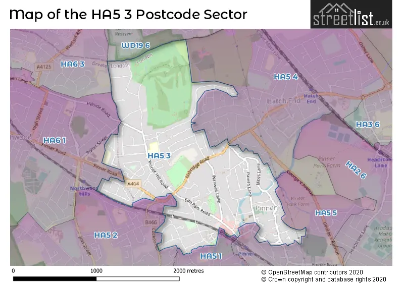
The HA5 3 postcode sector stands on the Greater London and Hertfordshire border.
Did you know? According to the 2021 Census, the HA5 3 postcode sector is home to a bustling 11,413 residents!
Given that each sector allows for 400 unique postcode combinations. Letters C, I, K, M, O and V are not allowed in the last two letters of a postcode. With 271 postcodes already in use, this leaves 129 units available.
The largest settlement in the HA5 3 postal code is PINNER followed by NORTHWOOD , and HATCH END .
The HA5 3 Postcode shares a border with WD19 6 (SOUTH OXHEY ), HA5 1 (PINNER , EASTCOTE , RUISLIP ), HA5 2 (EASTCOTE , PINNER , NORTHWOOD ), HA5 4 (PINNER , HATCH END ), HA5 5 (PINNER , HARROW , RAYNERS LANE ), HA6 1 (NORTHWOOD ) and HA6 3 (NORTHWOOD ).
The sector is within the post town of PINNER.
HA5 3 is a postcode sector within the HA5 postcode district which is within the HA Harrow postcode area.
The Royal Mail delivery office for the HA5 3 postal sector is the Pinner Delivery Office.
The area of the HA5 3 postcode sector is 1.25 square miles which is 3.23 square kilometres or 797.22 square acres.
Waterways within the HA5 3 postcode sector include the River Pinn, Pinn.

Map of the HA5 3 Postcode Sector
Explore the HA5 3 postcode sector by using our free interactive map.
| H | A | 5 | - | 3 | X | X |
| H | A | 5 | Space | 3 | Letter | Letter |
Official List of Streets
PINNER (104 Streets)
Unofficial Streets or Alternative Spellings
PINNER
ASH HILL DRIVE BELL CLOSE BISHOPS WALK CHAPEL LANE ELM PARK COURT GILBERT ROAD GRANGE GARDENS HIGH STREET MARSH ROAD MARSWORTH AVENUE MONTESOLE COURT NOWER HILL PINNER GREEN WOODHALL DRIVE WOODHALL GATEHARROW,
UXBRIDGE ROAD ASHBURTON COURT BEECHENGROVE BLOOMSBURY COURT CHERRY COURT CHISWICK COURT FAIRLAWNS GRANVILLE PLACE PINNORA MEWS R8 THE KNOLLNORTHWOOD,
HILLSIDE ROAD POTTER STREETNORTHWOOD
PINNER ROADWeather Forecast for HA5 3
Press Button to Show Forecast for Northwood
| Time Period | Icon | Description | Temperature | Rain Probability | Wind |
|---|---|---|---|---|---|
| 15:00 to 18:00 | Cloudy | 10.0°C (feels like 8.0°C) | 10.00% | NE 9 mph | |
| 18:00 to 21:00 | Heavy rain | 9.0°C (feels like 6.0°C) | 94.00% | NE 11 mph | |
| 21:00 to 00:00 | Heavy rain | 8.0°C (feels like 4.0°C) | 93.00% | NNE 13 mph |
Press Button to Show Forecast for Northwood
| Time Period | Icon | Description | Temperature | Rain Probability | Wind |
|---|---|---|---|---|---|
| 00:00 to 03:00 | Heavy rain | 8.0°C (feels like 4.0°C) | 87.00% | NNE 13 mph | |
| 03:00 to 06:00 | Heavy rain | 8.0°C (feels like 5.0°C) | 91.00% | NNE 9 mph | |
| 06:00 to 09:00 | Light rain shower (day) | 8.0°C (feels like 5.0°C) | 45.00% | NNW 7 mph | |
| 09:00 to 12:00 | Heavy rain | 7.0°C (feels like 4.0°C) | 79.00% | NW 11 mph | |
| 12:00 to 15:00 | Light rain | 7.0°C (feels like 3.0°C) | 47.00% | W 16 mph | |
| 15:00 to 18:00 | Cloudy | 9.0°C (feels like 7.0°C) | 14.00% | WSW 11 mph | |
| 18:00 to 21:00 | Cloudy | 10.0°C (feels like 9.0°C) | 6.00% | SW 7 mph | |
| 21:00 to 00:00 | Clear night | 8.0°C (feels like 6.0°C) | 1.00% | SW 7 mph |
Press Button to Show Forecast for Northwood
| Time Period | Icon | Description | Temperature | Rain Probability | Wind |
|---|---|---|---|---|---|
| 00:00 to 03:00 | Clear night | 6.0°C (feels like 4.0°C) | 1.00% | SW 7 mph | |
| 03:00 to 06:00 | Clear night | 5.0°C (feels like 3.0°C) | 0.00% | SSW 7 mph | |
| 06:00 to 09:00 | Sunny day | 6.0°C (feels like 4.0°C) | 0.00% | S 7 mph | |
| 09:00 to 12:00 | Partly cloudy (day) | 11.0°C (feels like 9.0°C) | 1.00% | SSW 13 mph | |
| 12:00 to 15:00 | Partly cloudy (day) | 13.0°C (feels like 11.0°C) | 2.00% | SSW 13 mph | |
| 15:00 to 18:00 | Partly cloudy (day) | 14.0°C (feels like 11.0°C) | 1.00% | SSW 16 mph | |
| 18:00 to 21:00 | Sunny day | 13.0°C (feels like 11.0°C) | 1.00% | S 9 mph | |
| 21:00 to 00:00 | Clear night | 9.0°C (feels like 8.0°C) | 0.00% | SSE 7 mph |
Press Button to Show Forecast for Northwood
| Time Period | Icon | Description | Temperature | Rain Probability | Wind |
|---|---|---|---|---|---|
| 00:00 to 03:00 | Clear night | 8.0°C (feels like 6.0°C) | 1.00% | SE 7 mph | |
| 03:00 to 06:00 | Clear night | 7.0°C (feels like 5.0°C) | 0.00% | ESE 7 mph | |
| 06:00 to 09:00 | Sunny day | 9.0°C (feels like 7.0°C) | 1.00% | ESE 4 mph | |
| 09:00 to 12:00 | Sunny day | 14.0°C (feels like 12.0°C) | 8.00% | SE 7 mph | |
| 12:00 to 15:00 | Cloudy | 15.0°C (feels like 13.0°C) | 13.00% | SSE 11 mph | |
| 15:00 to 18:00 | Cloudy | 15.0°C (feels like 14.0°C) | 13.00% | SSE 9 mph | |
| 18:00 to 21:00 | Cloudy | 15.0°C (feels like 13.0°C) | 12.00% | SSE 7 mph | |
| 21:00 to 00:00 | Cloudy | 11.0°C (feels like 10.0°C) | 13.00% | SE 4 mph |
Press Button to Show Forecast for Northwood
| Time Period | Icon | Description | Temperature | Rain Probability | Wind |
|---|---|---|---|---|---|
| 00:00 to 03:00 | Cloudy | 10.0°C (feels like 9.0°C) | 15.00% | ESE 4 mph | |
| 03:00 to 06:00 | Cloudy | 9.0°C (feels like 9.0°C) | 13.00% | ENE 4 mph | |
| 06:00 to 09:00 | Fog | 9.0°C (feels like 9.0°C) | 22.00% | NE 4 mph | |
| 09:00 to 12:00 | Cloudy | 13.0°C (feels like 13.0°C) | 13.00% | ENE 4 mph | |
| 12:00 to 15:00 | Cloudy | 16.0°C (feels like 16.0°C) | 14.00% | ESE 7 mph | |
| 15:00 to 18:00 | Cloudy | 17.0°C (feels like 16.0°C) | 19.00% | SSE 7 mph | |
| 18:00 to 21:00 | Cloudy | 16.0°C (feels like 15.0°C) | 14.00% | S 4 mph | |
| 21:00 to 00:00 | Cloudy | 13.0°C (feels like 12.0°C) | 17.00% | NNW 7 mph |
Schools and Places of Education Within the HA5 3 Postcode Sector
Pinner Wood School
Community school
Latimer Gardens, Pinner, , HA5 3RA
Head: Miss Sarah Marriott
Ofsted Rating: Outstanding
Inspection: 2023-12-07 (142 days ago)
Website: Visit Pinner Wood School Website
Phone: 02088682468
Number of Pupils: 666
House Prices in the HA5 3 Postcode Sector
| Type of Property | 2018 Average | 2018 Sales | 2017 Average | 2017 Sales | 2016 Average | 2016 Sales | 2015 Average | 2015 Sales |
|---|---|---|---|---|---|---|---|---|
| Detached | £980,208 | 36 | £1,024,625 | 28 | £1,034,893 | 38 | £1,023,226 | 53 |
| Semi-Detached | £676,022 | 23 | £698,719 | 32 | £754,056 | 25 | £603,107 | 41 |
| Terraced | £508,864 | 11 | £619,333 | 15 | £600,179 | 14 | £290,831 | 40 |
| Flats | £355,438 | 50 | £344,023 | 41 | £341,645 | 53 | £284,184 | 79 |
Important Postcodes HA5 3 in the Postcode Sector
HA5 3EE is the postcode for Pinn Medical Centre, 37 Love Lane, and The Pinn Medical Centre, 37 Love Lane
HA5 3JB is the postcode for Royal Mail, Pinner Delivery Office, 67 Bridge Street
HA5 3RA is the postcode for Pinner Wood School, Latimer Gardens
HA5 3TD is the postcode for Bedford House, James Bedford Close
HA5 3UJ is the postcode for Edwin Ware Court, Crossway
| The HA5 3 Sector is within these Local Authorities |
|
|---|---|
| The HA5 3 Sector is within these Counties |
|
| The HA5 3 Sector is within these Water Company Areas |
|