The HA6 2 postcode sector stands on the Greater London and Hertfordshire border.
Did you know? According to the 2021 Census, the HA6 2 postcode sector is home to a bustling 8,625 residents!
Given that each sector allows for 400 unique postcode combinations. Letters C, I, K, M, O and V are not allowed in the last two letters of a postcode. With 292 postcodes already in use, this leaves 108 units available.
The largest settlements in the HA6 2 postal code are NORTHWOOD and MOOR PARK .
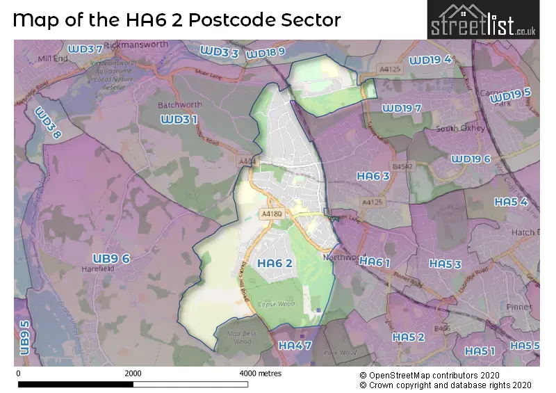
The HA6 2 Postcode shares a border with WD19 4 (WATFORD , OXHEY HALL ), WD19 7 (SOUTH OXHEY ), WD18 9 (RICKMANSWORTH , WATFORD , OXHEY HALL ), UB9 6 (HAREFIELD ), WD3 1 (RICKMANSWORTH , MOOR PARK ), HA4 7 (RUISLIP ), HA6 1 (NORTHWOOD ) and HA6 3 (NORTHWOOD ).
The sector is within the post town of NORTHWOOD.
HA6 2 is a postcode sector within the HA6 postcode district which is within the HA Harrow postcode area.
The Royal Mail delivery office for the HA6 2 postal sector is the Northwood Delivery Office.
The area of the HA6 2 postcode sector is 3.13 square miles which is 8.10 square kilometres or 2,001.10 square acres.

Map of the HA6 2 Postcode Sector
Explore the HA6 2 postcode sector by using our free interactive map.
| H | A | 6 | - | 2 | X | X |
| H | A | 6 | Space | 2 | Letter | Letter |
Official List of Streets
NORTHWOOD (113 Streets)
Unofficial Streets or Alternative Spellings
NORTHWOOD
CLIVE PARADE EASTBURY ROAD HALLOWELL ROAD HIGHFIELD CLOSE HIGHFIELD CRESCENT OAKLANDS GATE SANDY LANE WESTBURY ROAD CENTRAL WAY EAST DRIVE HILLINGDON TRAIL IVY WALK LINKS WAY R10 R11 R188 R189 R190 R27 R28 R29 R3 R36 R37 R38 R59 R62 R67 R68 R69 R70 R73 R74 R79 ROWLAND PLACE SAINT MARTINS THE LONG DRIVENORTHWOOD,
DUCKS HILL ROADWATFORD
HAMPERMILL LANERICKMANSWORTH
SANDY LODGE ROADHarefield
BREAKSPEAR ROAD NORTH JACKETS LANEWeather Forecast for HA6 2
Press Button to Show Forecast for Northwood
| Time Period | Icon | Description | Temperature | Rain Probability | Wind |
|---|---|---|---|---|---|
| 15:00 to 18:00 | Cloudy | 10.0°C (feels like 9.0°C) | 7.00% | ENE 4 mph | |
| 18:00 to 21:00 | Overcast | 10.0°C (feels like 8.0°C) | 13.00% | ENE 9 mph | |
| 21:00 to 00:00 | Cloudy | 8.0°C (feels like 6.0°C) | 11.00% | E 9 mph |
Press Button to Show Forecast for Northwood
| Time Period | Icon | Description | Temperature | Rain Probability | Wind |
|---|---|---|---|---|---|
| 00:00 to 03:00 | Overcast | 7.0°C (feels like 4.0°C) | 18.00% | ENE 9 mph | |
| 03:00 to 06:00 | Light rain | 6.0°C (feels like 3.0°C) | 53.00% | NE 9 mph | |
| 06:00 to 09:00 | Light rain | 6.0°C (feels like 3.0°C) | 52.00% | NE 9 mph | |
| 09:00 to 12:00 | Overcast | 7.0°C (feels like 4.0°C) | 21.00% | NE 11 mph | |
| 12:00 to 15:00 | Overcast | 9.0°C (feels like 7.0°C) | 13.00% | ENE 9 mph | |
| 15:00 to 18:00 | Overcast | 11.0°C (feels like 9.0°C) | 15.00% | NE 9 mph | |
| 18:00 to 21:00 | Cloudy | 10.0°C (feels like 7.0°C) | 50.00% | NE 11 mph | |
| 21:00 to 00:00 | Light rain | 8.0°C (feels like 6.0°C) | 60.00% | NE 11 mph |
Press Button to Show Forecast for Northwood
| Time Period | Icon | Description | Temperature | Rain Probability | Wind |
|---|---|---|---|---|---|
| 00:00 to 03:00 | Heavy rain | 8.0°C (feels like 5.0°C) | 85.00% | NNE 11 mph | |
| 03:00 to 06:00 | Heavy rain | 8.0°C (feels like 5.0°C) | 88.00% | NNE 11 mph | |
| 06:00 to 09:00 | Heavy rain | 8.0°C (feels like 5.0°C) | 83.00% | WNW 9 mph | |
| 09:00 to 12:00 | Heavy rain | 8.0°C (feels like 5.0°C) | 82.00% | NW 9 mph | |
| 12:00 to 15:00 | Light rain | 8.0°C (feels like 6.0°C) | 58.00% | WNW 11 mph | |
| 15:00 to 18:00 | Cloudy | 10.0°C (feels like 7.0°C) | 18.00% | W 9 mph | |
| 18:00 to 21:00 | Cloudy | 10.0°C (feels like 8.0°C) | 8.00% | WSW 7 mph | |
| 21:00 to 00:00 | Cloudy | 8.0°C (feels like 7.0°C) | 6.00% | SW 7 mph |
Press Button to Show Forecast for Northwood
| Time Period | Icon | Description | Temperature | Rain Probability | Wind |
|---|---|---|---|---|---|
| 00:00 to 03:00 | Partly cloudy (night) | 7.0°C (feels like 5.0°C) | 2.00% | SW 4 mph | |
| 03:00 to 06:00 | Clear night | 6.0°C (feels like 4.0°C) | 1.00% | SSW 4 mph | |
| 06:00 to 09:00 | Sunny day | 6.0°C (feels like 5.0°C) | 1.00% | S 4 mph | |
| 09:00 to 12:00 | Partly cloudy (day) | 11.0°C (feels like 9.0°C) | 1.00% | S 9 mph | |
| 12:00 to 15:00 | Cloudy | 13.0°C (feels like 11.0°C) | 5.00% | S 11 mph | |
| 15:00 to 18:00 | Partly cloudy (day) | 15.0°C (feels like 12.0°C) | 3.00% | S 11 mph | |
| 18:00 to 21:00 | Sunny day | 13.0°C (feels like 11.0°C) | 1.00% | S 9 mph | |
| 21:00 to 00:00 | Clear night | 11.0°C (feels like 9.0°C) | 1.00% | SSE 7 mph |
Press Button to Show Forecast for Northwood
| Time Period | Icon | Description | Temperature | Rain Probability | Wind |
|---|---|---|---|---|---|
| 00:00 to 03:00 | Clear night | 9.0°C (feels like 8.0°C) | 1.00% | SE 7 mph | |
| 03:00 to 06:00 | Clear night | 8.0°C (feels like 7.0°C) | 2.00% | ESE 7 mph | |
| 06:00 to 09:00 | Sunny day | 9.0°C (feels like 7.0°C) | 4.00% | ESE 7 mph | |
| 09:00 to 12:00 | Partly cloudy (day) | 12.0°C (feels like 11.0°C) | 5.00% | SE 9 mph | |
| 12:00 to 15:00 | Cloudy | 15.0°C (feels like 13.0°C) | 11.00% | SE 9 mph | |
| 15:00 to 18:00 | Cloudy | 16.0°C (feels like 14.0°C) | 14.00% | SE 9 mph | |
| 18:00 to 21:00 | Cloudy | 15.0°C (feels like 13.0°C) | 10.00% | SE 9 mph | |
| 21:00 to 00:00 | Cloudy | 13.0°C (feels like 11.0°C) | 8.00% | ESE 7 mph |
Schools and Places of Education Within the HA6 2 Postcode Sector
Holy Trinity CofE Primary School
Voluntary aided school
Rickmansworth Road, Middlesex, , HA6 2RH
Head: Mrs Rachel Blake
Ofsted Rating: Good
Inspection: 2023-05-05 (357 days ago)
Website: Visit Holy Trinity CofE Primary School Website
Phone: 01923822529
Number of Pupils: 187
House Prices in the HA6 2 Postcode Sector
| Type of Property | 2018 Average | 2018 Sales | 2017 Average | 2017 Sales | 2016 Average | 2016 Sales | 2015 Average | 2015 Sales |
|---|---|---|---|---|---|---|---|---|
| Detached | £1,799,309 | 44 | £1,580,387 | 50 | £1,547,236 | 57 | £1,516,014 | 61 |
| Semi-Detached | £853,571 | 7 | £828,125 | 8 | £676,125 | 4 | £972,000 | 11 |
| Terraced | £494,167 | 6 | £570,818 | 11 | £519,750 | 8 | £487,775 | 18 |
| Flats | £467,276 | 29 | £508,989 | 44 | £587,739 | 71 | £438,852 | 49 |
Important Postcodes HA6 2 in the Postcode Sector
HA6 2JW is the postcode for Bishops Wood Hospital, Rickmansworth Road
HA6 2RG is the postcode for The Mountwood Surgery, Rickmansworth Road
HA6 2RH is the postcode for HOLY TRINITY SCHOOL, RICKMANSWORTH ROAD, NORTHWOOD
HA6 2RN is the postcode for TREATMENT CENTRE & PCU, The Hillingdon Hospital NHS Trust, Mount Vernon Hospital, MAIN BLOCK, The Hillingdon Hospital NHS Trust, Mount Vernon Hospital, MEDICAL BLOCK, The Hillingdon Hospital NHS Trust, Mount Vernon Hospital, ADMIN AND RESTAURANT BLOCK, The Hillingdon Hospital NHS Trust, Mount Vernon Hospital, TREATMENT CENTRE, Mount Vernon Hospital, Rickmansworth Road, BUILDING 43, The Hillingdon Hospital NHS Trust, Mount Vernon Hospital, and The Hillingdon Hospital NHS Trust, Mount Vernon Hospital
HA6 2YN is the postcode for Metropolitan Police, Northwood Police Station, 2 Murray Road
| The HA6 2 Sector is within these Local Authorities |
|
|---|---|
| The HA6 2 Sector is within these Counties |
|
| The HA6 2 Sector is within these Water Company Areas |
|