The HA8 postcode district is a postal district located in the HA Harrow postcode area with a population of 71,824 residents according to the 2021 England and Wales Census.
The area of the HA8 postcode district is 4.57 square miles which is 11.83 square kilometres or 2,923.98 acres.
Currently, the HA8 district has about 1409 postcode units spread across 6 geographic postcode sectors.
Given that each sector allows for 400 unique postcode combinations, the district has a capacity of 2,400 postcodes. With 1409 postcodes already in use, this leaves 991 units available.
The HA8 postal code covers the settlement of EDGWARE.
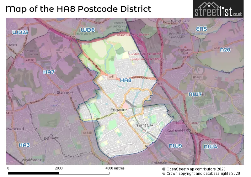
The HA8 Postcode shares a border with WD6 (BOREHAMWOOD, ELSTREE), NW7 (MILL HILL), NW9 (COLINDALE, LONDON) and HA7 (STANMORE).
The primary settlement in the HA8 postcode district is Edgware, located in the Greater London county. Other significant settlements in the district include Edgware as well. The postal town associated with the HA8 postcode district is Edgware, which is part of Greater London.
For the district HA8, we have data on 7 postcode sectors. Here's a breakdown: The sector HA8 0, covers Edgware in Greater London. The sector HA8 4 is non-geographic. It's often designated for PO Boxes, large organisations, or special services. The sector HA8 5, covers Edgware in Greater London. The sector HA8 6, covers Edgware in Greater London. The sector HA8 7, covers Edgware in Greater London. The sector HA8 8, covers Edgware in Greater London. The sector HA8 9, covers Edgware in Greater London.


Map of the HA8 Postcode District
Explore the HA8 postcode district by using our free interactive map.
When it comes to local government, postal geography often disregards political borders. However, for a breakdown in the HA8 District: the district mostly encompasses the Barnet London Boro (953 postcodes), followed by the Harrow London Boro area (397 postcodes), and finally, the Brent London Boro area (62 postcodes).
Recent House Sales in HA8
| Date | Price | Address |
|---|---|---|
| 19/10/2023 | £710,000 | Cheyneys Avenue, Edgware, HA8 6SE |
| 19/10/2023 | £1,375,000 | Lake View, Edgware, HA8 7SA |
| 12/10/2023 | £449,500 | Hale Lane, Edgware, HA8 8WG |
| 15/09/2023 | £468,000 | Kenilworth Road, Edgware, HA8 8XD |
| 15/09/2023 | £653,000 | Wolmer Gardens, Edgware, HA8 8QD |
| 15/09/2023 | £395,000 | Stratton Close, Edgware, HA8 6PR |
| 13/09/2023 | £675,000 | St Margarets Road, Edgware, HA8 9UU |
| 07/09/2023 | £500,000 | Mowbray Road, Edgware, HA8 8JH |
| 05/09/2023 | £590,000 | Lovatt Close, Edgware, HA8 9XG |
| 04/09/2023 | £530,000 | Raeburn Road, Edgware, HA8 5TP |
Weather Forecast for HA8
Press Button to Show Forecast for Borehamwood
| Time Period | Icon | Description | Temperature | Rain Probability | Wind |
|---|---|---|---|---|---|
| 12:00 to 15:00 | Overcast | 9.0°C (feels like 7.0°C) | 16.00% | ENE 9 mph | |
| 15:00 to 18:00 | Cloudy | 11.0°C (feels like 9.0°C) | 14.00% | NE 9 mph | |
| 18:00 to 21:00 | Overcast | 10.0°C (feels like 8.0°C) | 22.00% | NE 11 mph | |
| 21:00 to 00:00 | Heavy rain | 9.0°C (feels like 6.0°C) | 80.00% | NE 11 mph |
Press Button to Show Forecast for Borehamwood
| Time Period | Icon | Description | Temperature | Rain Probability | Wind |
|---|---|---|---|---|---|
| 00:00 to 03:00 | Heavy rain | 8.0°C (feels like 5.0°C) | 84.00% | NNE 11 mph | |
| 03:00 to 06:00 | Heavy rain | 8.0°C (feels like 5.0°C) | 89.00% | NNE 11 mph | |
| 06:00 to 09:00 | Heavy rain | 8.0°C (feels like 5.0°C) | 86.00% | NNW 9 mph | |
| 09:00 to 12:00 | Heavy rain | 8.0°C (feels like 6.0°C) | 81.00% | NW 9 mph | |
| 12:00 to 15:00 | Heavy rain | 9.0°C (feels like 6.0°C) | 77.00% | WNW 11 mph | |
| 15:00 to 18:00 | Overcast | 10.0°C (feels like 7.0°C) | 23.00% | W 9 mph | |
| 18:00 to 21:00 | Cloudy | 10.0°C (feels like 8.0°C) | 9.00% | W 7 mph | |
| 21:00 to 00:00 | Cloudy | 8.0°C (feels like 7.0°C) | 5.00% | SW 7 mph |
Press Button to Show Forecast for Borehamwood
| Time Period | Icon | Description | Temperature | Rain Probability | Wind |
|---|---|---|---|---|---|
| 00:00 to 03:00 | Clear night | 7.0°C (feels like 5.0°C) | 2.00% | SW 7 mph | |
| 03:00 to 06:00 | Clear night | 6.0°C (feels like 4.0°C) | 1.00% | SSW 4 mph | |
| 06:00 to 09:00 | Sunny day | 7.0°C (feels like 5.0°C) | 1.00% | S 4 mph | |
| 09:00 to 12:00 | Sunny day | 11.0°C (feels like 9.0°C) | 1.00% | S 9 mph | |
| 12:00 to 15:00 | Cloudy | 14.0°C (feels like 11.0°C) | 6.00% | S 11 mph | |
| 15:00 to 18:00 | Partly cloudy (day) | 15.0°C (feels like 12.0°C) | 3.00% | S 11 mph | |
| 18:00 to 21:00 | Sunny day | 14.0°C (feels like 12.0°C) | 1.00% | S 9 mph | |
| 21:00 to 00:00 | Clear night | 11.0°C (feels like 9.0°C) | 1.00% | SSE 7 mph |
Press Button to Show Forecast for Borehamwood
| Time Period | Icon | Description | Temperature | Rain Probability | Wind |
|---|---|---|---|---|---|
| 00:00 to 03:00 | Clear night | 9.0°C (feels like 8.0°C) | 1.00% | SE 7 mph | |
| 03:00 to 06:00 | Clear night | 8.0°C (feels like 7.0°C) | 3.00% | ESE 7 mph | |
| 06:00 to 09:00 | Sunny day | 9.0°C (feels like 7.0°C) | 4.00% | ESE 7 mph | |
| 09:00 to 12:00 | Partly cloudy (day) | 12.0°C (feels like 11.0°C) | 4.00% | SE 9 mph | |
| 12:00 to 15:00 | Cloudy | 15.0°C (feels like 13.0°C) | 10.00% | SE 9 mph | |
| 15:00 to 18:00 | Cloudy | 16.0°C (feels like 14.0°C) | 12.00% | SE 9 mph | |
| 18:00 to 21:00 | Cloudy | 15.0°C (feels like 14.0°C) | 12.00% | SE 9 mph | |
| 21:00 to 00:00 | Cloudy | 13.0°C (feels like 12.0°C) | 9.00% | ESE 7 mph |
Where is the HA8 Postcode District?
The postcode district HA8 is located in the town of Edgware. It is surrounded by nearby towns such as Stonegrove Estate to the North West (0.55 miles away), Burnt Oak Broadway to Deans Lane to the South (0.56 miles away), The Hale to the East (0.57 miles away), Deans Lane to Lyndhurst Avenue to the South East (0.79 miles away), and Apex Corner to the North East (1.03 miles away). Edgware is approximately 9.89 miles away from the center of London.
The district is within the post town of EDGWARE.
The sector has postcodes within the nation of England.
The HA8 Postcode District is covers the following regions.
- Barnet - Outer London - West and North West - London
- Harrow and Hillingdon - Outer London - West and North West - London
- Brent - Outer London - West and North West - London
| Postcode Sector | Delivery Office |
|---|---|
| HA8 0 | Edgware Delivery Office |
| HA8 5 | Edgware Delivery Office |
| HA8 6 | Edgware Delivery Office |
| HA8 7 | Edgware Delivery Office |
| HA8 8 | Edgware Delivery Office |
| HA8 9 | Edgware Delivery Office |
| H | A | 8 | - | X | X | X |
| H | A | 8 | Space | Numeric | Letter | Letter |
Current Monthly Rental Prices
| # Bedrooms | Min Price | Max Price | Avg Price |
|---|---|---|---|
| £900 | £2,500 | £1,242 | |
| 1 | £800 | £1,600 | £1,337 |
| 2 | £1,500 | £2,200 | £1,788 |
| 3 | £2,300 | £3,200 | £2,593 |
| 4 | £2,495 | £3,750 | £2,999 |
| 5 | £3,500 | £3,750 | £3,625 |
| 6 | £3,995 | £3,995 | £3,995 |
Current House Prices
| # Bedrooms | Min Price | Max Price | Avg Price |
|---|---|---|---|
| £199,950 | £225,000 | £212,475 | |
| 1 | £165,000 | £375,000 | £283,646 |
| 2 | £127,500 | £750,000 | £395,683 |
| 3 | £250,000 | £995,000 | £621,962 |
| 4 | £385,000 | £1,500,000 | £866,506 |
| 5 | £650,000 | £3,000,000 | £1,075,176 |
| 6 | £950,000 | £2,250,000 | £1,600,000 |
| 7 | £999,950 | £999,950 | £999,950 |
| 8 | £845,000 | £845,000 | £845,000 |
Estate Agents who Operate in the HA8 District
| Logo | Name | Brand Name | Address | Contact Number | Total Properties |
|---|---|---|---|---|---|
 | Edgware | Joseph Scott | 172/174 Deans Lane, Edgware, HA8 9NT | 020 8629 6927 | 44 |
 | Edgware | Benjamin Stevens | 194 Station Road, Edgware, HA8 7AT | 020 3893 8927 | 37 |
 | Stanmore | Foxtons | 40 Church Road, Stanmore, HA7 4AH | 020 3828 7684 | 20 |
 | Stanmore | Chancellors | 38 The Broadway, Stanmore, HA7 4DU | 020 3879 4785 | 18 |
 | Edgware | Bladon Sears | Mowbray Parade, 86 Edgware Way, Edgware, Middlesex HA8 8JS | 020 8138 9239 | 17 |
| Type of Property | 2018 Average | 2018 Sales | 2017 Average | 2017 Sales | 2016 Average | 2016 Sales | 2015 Average | 2015 Sales |
|---|---|---|---|---|---|---|---|---|
| Detached | £945,419 | 48 | £847,859 | 32 | £820,516 | 31 | £740,529 | 56 |
| Semi-Detached | £584,149 | 172 | £589,010 | 164 | £600,542 | 180 | £504,012 | 235 |
| Terraced | £435,647 | 103 | £495,801 | 208 | £401,309 | 135 | £435,755 | 234 |
| Flats | £324,541 | 131 | £334,058 | 168 | £334,524 | 501 | £296,663 | 379 |