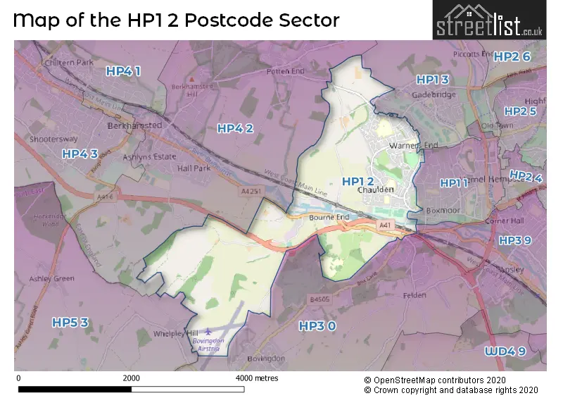
The HP1 2 postcode sector stands on the Buckinghamshire and Hertfordshire border.
Did you know? According to the 2021 Census, the HP1 2 postcode sector is home to a bustling 8,600 residents!
Given that each sector allows for 400 unique postcode combinations. Letters C, I, K, M, O and V are not allowed in the last two letters of a postcode. With 192 postcodes already in use, this leaves 208 units available.
The HP1 2 postal code covers the settlement of HEMEL HEMPSTEAD.
The HP1 2 Postcode shares a border with HP1 3 (HEMEL HEMPSTEAD, Great Gaddesden, Water End), HP3 0 (BOVINGDON, HEMEL HEMPSTEAD, Felden), HP1 1 (HEMEL HEMPSTEAD), HP3 9 (HEMEL HEMPSTEAD, Nash Mills Wharf, APSLEY), HP4 2 (BERKHAMSTED, Potten End) and HP5 3 (CHESHAM, Ashley Green, Whelpley Hill).
The sector is within the post town of HEMEL HEMPSTEAD.
HP1 2 is a postcode sector within the HP1 postcode district which is within the HP Hemel Hempstead postcode area.
The Royal Mail delivery office for the HP1 2 postal sector is the Hemel Hempstead Delivery Office.
The area of the HP1 2 postcode sector is 3.86 square miles which is 10.00 square kilometres or 2,470.55 square acres.
Waterways within the HP1 2 postcode sector include the Grand Union Canal, Bourne Gutter.

Map of the HP1 2 Postcode Sector
Explore the HP1 2 postcode sector by using our free interactive map.
| H | P | 1 | - | 2 | X | X |
| H | P | 1 | Space | 2 | Letter | Letter |
Official List of Streets
HEMEL HEMPSTEAD (111 Streets)
Unofficial Streets or Alternative Spellings
HEMEL HEMPSTEAD
ASHTREE WAY BARBERRY ROAD BODWELL CLOSE BOX LANE CANGELS CLOSE COPPER BEECH CLOSE GALLEY HILL GREEN END ROAD GROVE ROAD HASEDINES ROAD KNIGHTS ORCHARD LYNE WAY MEADOW WAY PEARTREE ROAD POLEHANGER LANE WARMARK ROAD WHITEBROOM ROADFelden
FELDEN LANE BROWNLOW FARM DAGGS DELL ROAD LAURIES CLOSE MIDDLEHILL MOUNTS HILL SAINT NICHOLAS MOUNT ST MARYS PLACE THE AVENUE THE CHILTERN WAY WINKWELLPotten End
HEMPSTEAD LANEBERKHAMSTED
SWING GATE LANELittle Heath
LITTLE HEATH LANEShendish
LONDON ROADWeather Forecast for HP1 2
Press Button to Show Forecast for Berkhamsted
| Time Period | Icon | Description | Temperature | Rain Probability | Wind |
|---|---|---|---|---|---|
| 12:00 to 15:00 | Light rain | 6.0°C (feels like 2.0°C) | 61.00% | W 13 mph | |
| 15:00 to 18:00 | Light rain | 8.0°C (feels like 5.0°C) | 80.00% | SW 9 mph | |
| 18:00 to 21:00 | Cloudy | 9.0°C (feels like 7.0°C) | 7.00% | SW 9 mph | |
| 21:00 to 00:00 | Clear night | 7.0°C (feels like 5.0°C) | 3.00% | SSW 7 mph |
Press Button to Show Forecast for Berkhamsted
| Time Period | Icon | Description | Temperature | Rain Probability | Wind |
|---|---|---|---|---|---|
| 00:00 to 03:00 | Clear night | 5.0°C (feels like 2.0°C) | 0.00% | SSW 7 mph | |
| 03:00 to 06:00 | Clear night | 4.0°C (feels like 2.0°C) | 0.00% | SSW 7 mph | |
| 06:00 to 09:00 | Sunny day | 6.0°C (feels like 4.0°C) | 0.00% | S 9 mph | |
| 09:00 to 12:00 | Sunny day | 11.0°C (feels like 9.0°C) | 2.00% | SSW 16 mph | |
| 12:00 to 15:00 | Cloudy | 14.0°C (feels like 11.0°C) | 5.00% | S 16 mph | |
| 15:00 to 18:00 | Partly cloudy (day) | 14.0°C (feels like 11.0°C) | 1.00% | SSW 16 mph | |
| 18:00 to 21:00 | Sunny day | 12.0°C (feels like 10.0°C) | 0.00% | S 11 mph | |
| 21:00 to 00:00 | Clear night | 9.0°C (feels like 7.0°C) | 0.00% | SSE 9 mph |
Press Button to Show Forecast for Berkhamsted
| Time Period | Icon | Description | Temperature | Rain Probability | Wind |
|---|---|---|---|---|---|
| 00:00 to 03:00 | Clear night | 8.0°C (feels like 6.0°C) | 0.00% | SSE 7 mph | |
| 03:00 to 06:00 | Clear night | 7.0°C (feels like 5.0°C) | 0.00% | SE 7 mph | |
| 06:00 to 09:00 | Sunny day | 8.0°C (feels like 6.0°C) | 0.00% | SE 7 mph | |
| 09:00 to 12:00 | Sunny day | 13.0°C (feels like 11.0°C) | 1.00% | SSE 11 mph | |
| 12:00 to 15:00 | Cloudy | 16.0°C (feels like 13.0°C) | 7.00% | SSE 13 mph | |
| 15:00 to 18:00 | Cloudy | 15.0°C (feels like 13.0°C) | 6.00% | SSE 11 mph | |
| 18:00 to 21:00 | Sunny day | 14.0°C (feels like 12.0°C) | 5.00% | SSE 9 mph | |
| 21:00 to 00:00 | Cloudy | 10.0°C (feels like 9.0°C) | 8.00% | SSE 7 mph |
Press Button to Show Forecast for Berkhamsted
| Time Period | Icon | Description | Temperature | Rain Probability | Wind |
|---|---|---|---|---|---|
| 00:00 to 03:00 | Cloudy | 10.0°C (feels like 9.0°C) | 9.00% | SE 4 mph | |
| 03:00 to 06:00 | Cloudy | 9.0°C (feels like 8.0°C) | 8.00% | S 4 mph | |
| 06:00 to 09:00 | Cloudy | 9.0°C (feels like 8.0°C) | 10.00% | NNE 4 mph | |
| 09:00 to 12:00 | Cloudy | 12.0°C (feels like 11.0°C) | 9.00% | NE 4 mph | |
| 12:00 to 15:00 | Cloudy | 15.0°C (feels like 14.0°C) | 13.00% | ENE 4 mph | |
| 15:00 to 18:00 | Cloudy | 15.0°C (feels like 14.0°C) | 14.00% | ESE 7 mph | |
| 18:00 to 21:00 | Cloudy | 14.0°C (feels like 13.0°C) | 12.00% | E 7 mph | |
| 21:00 to 00:00 | Cloudy | 12.0°C (feels like 10.0°C) | 11.00% | ESE 9 mph |
Press Button to Show Forecast for Berkhamsted
| Time Period | Icon | Description | Temperature | Rain Probability | Wind |
|---|---|---|---|---|---|
| 00:00 to 03:00 | Light rain | 10.0°C (feels like 8.0°C) | 54.00% | NW 9 mph | |
| 03:00 to 06:00 | Light rain | 10.0°C (feels like 8.0°C) | 55.00% | NW 9 mph | |
| 06:00 to 09:00 | Overcast | 10.0°C (feels like 8.0°C) | 17.00% | NNW 9 mph | |
| 09:00 to 12:00 | Overcast | 12.0°C (feels like 10.0°C) | 15.00% | WNW 9 mph | |
| 12:00 to 15:00 | Cloudy | 16.0°C (feels like 14.0°C) | 6.00% | NW 9 mph | |
| 15:00 to 18:00 | Partly cloudy (day) | 17.0°C (feels like 15.0°C) | 5.00% | NW 11 mph | |
| 18:00 to 21:00 | Partly cloudy (day) | 15.0°C (feels like 14.0°C) | 6.00% | N 9 mph | |
| 21:00 to 00:00 | Cloudy | 12.0°C (feels like 10.0°C) | 7.00% | N 9 mph |
Schools and Places of Education Within the HP1 2 Postcode Sector
Micklem Primary School
Community school
Boxted Road, Hemel Hempstead, Hertfordshire, HP1 2QH
Head: Mr Joshua Swift
Ofsted Rating: Good
Inspection: 2023-11-15 (165 days ago)
Website: Visit Micklem Primary School Website
Phone: 01442408964
Number of Pupils: 219
Pixies Hill Primary School
Community school
Hazeldell Road, Hemel Hempstead, Hertfordshire, HP1 2BY
Head: Mr Martin Smith
Ofsted Rating: Good
Inspection: 2023-04-26 (368 days ago)
Website: Visit Pixies Hill Primary School Website
Phone: 01442251793
Number of Pupils: 209
House Prices in the HP1 2 Postcode Sector
| Type of Property | 2018 Average | 2018 Sales | 2017 Average | 2017 Sales | 2016 Average | 2016 Sales | 2015 Average | 2015 Sales |
|---|---|---|---|---|---|---|---|---|
| Detached | £641,775 | 20 | £581,962 | 13 | £670,100 | 13 | £564,545 | 21 |
| Semi-Detached | £463,667 | 15 | £448,605 | 19 | £446,184 | 19 | £363,163 | 25 |
| Terraced | £340,652 | 61 | £349,880 | 67 | £317,977 | 67 | £277,670 | 59 |
| Flats | £239,864 | 11 | £212,589 | 14 | £220,354 | 24 | £195,541 | 11 |
Important Postcodes HP1 2 in the Postcode Sector
HP1 2BY is the postcode for Pixies Hill Primary School, Hazeldell Road, Pixies Hill Jmi School, Hazeldell Road, and PIXIES HILL JMI SCHOOL, HAZELDELL ROAD, HEMEL HEMPSTEAD
HP1 2JU is the postcode for Chaulden Junior School, School Row, and Chaulden Infants & Nursery School, School Row
HP1 2LD is the postcode for Doctors Surgery, Parkwood Drive
HP1 2PH is the postcode for BLOCK A, John F Kennedy Catholic School, Hollybush Lane, C BLOCK, John F Kennedy Catholic School, Hollybush Lane, M BLOCK, John F Kennedy Catholic School, Hollybush Lane, BLOCK D, John F Kennedy Catholic School, Hollybush Lane, John F Kennedy Catholic School, Hollybush Lane, and MAIN BUILDING, John F Kennedy Catholic School, Hollybush Lane
HP1 2QH is the postcode for Micklem Primary School, Boxted Road
| The HP1 2 Sector is within these Local Authorities |
|
|---|---|
| The HP1 2 Sector is within these Counties |
|
| The HP1 2 Sector is within these Water Company Areas |
|