This section of the site is all about the HP Postcode area, also known as the Hemel Hempstead Postal Area. Explore links to the next level to learn more about specific postcode districts such as HP1.
The HP postcode area represents a group of postal districts in the Hemel Hempstead area of the United Kingdom. The area code HP stands for the letters h and p in Hemel HemPstead. HP has a population of 488,351 and covers an area of 1,026,465 hectares. Fun fact: 0.75% of the population of Great Britain lives in this area.
The postcode area falls within the following counties: Buckinghamshire (73.76%), Hertfordshire (26.13%), Oxfordshire (0.10%), Bedfordshire (0.01%).
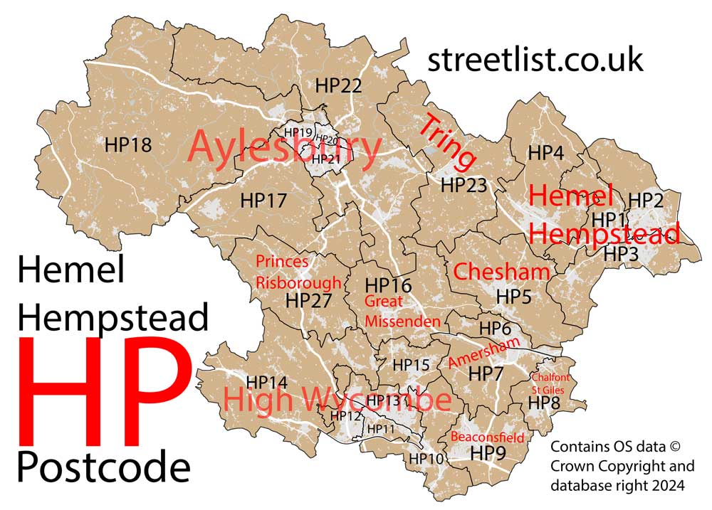
Post Towns and Postcode Districts for the HP Postcode
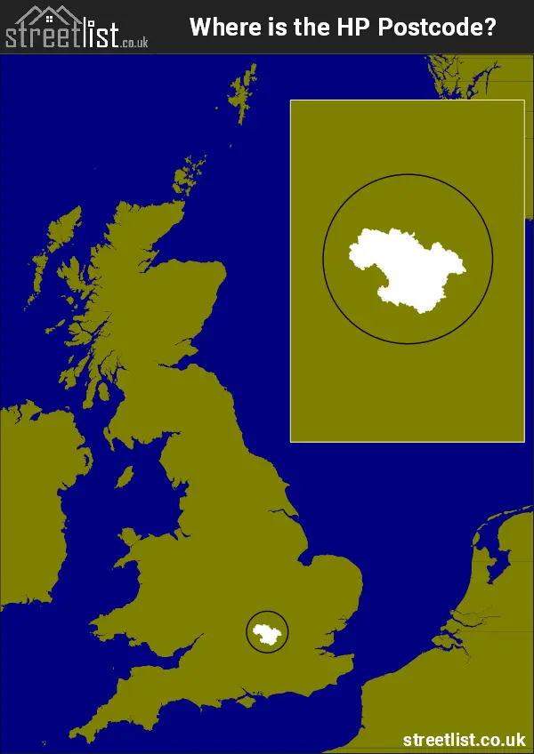
Where is the HP Postcode Area?
The HP Hemel Hempstead Postcode has most of it's area in South East England, with some of it's East in the East of England. The postal area borders the following neighbouring postal areas: OX - Oxford, SL - Slough, WD - Watford, RG - Reading, AL - St Albans, MK - Milton Keynes and LU - Luton, and is located inland.
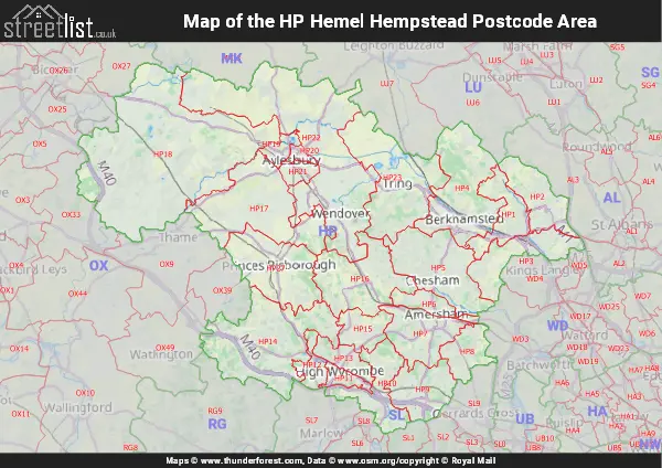
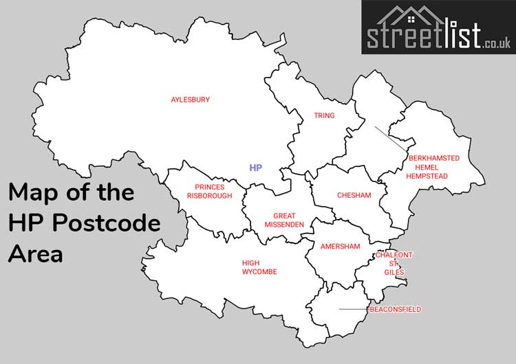
Map of the HP Hemel Hempstead Postcode Area
Explore the HP Hemel Hempstead postcode area by using our interactive map.
Postcode Districts within the HP Hemel Hempstead Postcode Area
There are 24 postcode districts within the Hemel Hempstead postcode area
A map showing the boundary of in relation to other areas
There are 11 towns within the Hemel Hempstead postcode area.
| Unit | Area² |
|---|---|
| Hectares | 1,026,465² |
| Miles | 3,963² |
| Feet | 110,487,666,135² |
| Kilometres | 10,265² |
Postal Delivery Offices serving the HP Hemel Hempstead Postcode Area
- Amersham Delivery Office
- Aylesbury Delivery Office
- Aylesbury Vale Postal Delivery Office
- Beaconsfield Delivery Office
- Berkhamsted Delivery Office
- Chesham Delivery Office
- Great Missenden Delivery Office
- Hazlemere Delivery Office
- Hemel Hempstead Delivery Office
- High Wycombe North Delivery Office
- High Wycombe South Postal Delivery Office
- Princes Risborough Delivery Office
- Tring Delivery Office
Councils with Postcodes in HP
Towns and Villages within the HP Hemel Hempstead Postcode Area
- Aldbury - village
- Amersham - town
- Ashendon - village
- Asheridge - village
- Ashley Green - village
- Askett - village
- Aston Abbotts - village
- Aston Clinton - village
- Aylesbury - town
- Ballinger Common - village
- Beacon's Bottom - village
- Beaconsfield - town
- Bellingdon - village
- Berkhamsted - town
- Bierton - village
- Bishopstone - village
- Bledlow - village
- Bledlow Ridge - village
- Bolter End - village
- Botley - village
- Bovingdon - village
- Bradenham - village
- Brill - village
- Bryant's Bottom - village
- Buckland - village
- Buckland Common - village
- Bulstrode - village
- Butler's Cross - village
- Cadmore End - village
- Chalfont St Giles - village
- Chartridge - village
- Chearsley - village
- Chesham - town
- Chilton - village
- Cholesbury - village
- Chorleywood - town
- Coleshill - village
- Cores End - village
- Cow Roast - village
- Cryers Hill - village
- Cuddington - village
- Dagnall - village
- Dinton - village
- Dorton - village
- Downley - village
- Edgcott - village
- Ellesborough - village
- Flackwell Heath - village
- Flaunden - village
- Ford - village
- Great Gaddesden - village
- Great Hampden - village
- Great Kingshill - village
- Great Missenden - village
- Grendon Underwood - village
- Haddenham - village
- Halton - village
- Hardwick - village
- Hawridge - village
- Hazlemere - village
- Hedsor - village
- Hemel Hempstead - town
- High Wycombe - town
- Hogpits Bottom - village
- Holmer Green - village
- Horsleys Green - village
- Hudnall - village
- Hughenden Valley - village
- Hyde Heath - village
- Ibstone - village
- Ickford - village
- Jockey End - village
- Jordans - village
- Kings Langley - otherSettlement
- Kingsey - village
- Kingswood - village
- Lacey Green - village
- Lane End - village
- Latimer - village
- Lee Common - village
- Ley Hill - village
- Little Chalfont - Settlement
- Little Gaddesden - village
- Little Kimble - village
- Little Kingshill - village
- Little Missenden - village
- Long Crendon - village
- Long Marston - village
- Longwick - village
- Loosley Row - village
- Loudwater - village
- Lower Winchendon - village
- Ludgershall - village
- Lye Green - village
- Marsworth - village
- Moor Common - village
- Naphill - village
- Oakley - village
- Oving - village
- Penn - village
- Penn Street - village
- Piddington - village
- Pimlico - village
- Pitch Green - village
- Potten End - village
- Prestwood - otherSettlement
- Princes Risborough - town
- Quainton - village
- Radnage - village
- Ringshall - village
- Rowsham - village
- Rucklers Lane - village
- Saunderton - village
- Saunderton - village
- Saunderton Lee - village
- Seer Green - village
- Shabbington - village
- South Heath - village
- Speen - village
- St Leonards - village
- Stoke Mandeville - village
- Stokenchurch - village
- Stone - village
- The City - village
- Tring - town
- Tylers Green - village
- Upper North Dean - village
- Upper Winchendon - village
- Upton - village
- Waddesdon - village
- Walter's Ash - village
- Water End - village
- Waterend - village
- Weedon - village
- Wendover - town
- West Wycombe - village
- Westcott - village
- Weston Turville - village
- Wheeler End - village
- Whelpley Hill - village
- Whitchurch - village
- Whiteleaf - village
- Widmer End - village
- Wigginton - village
- Wilstone - village
- Winchmore Hill - village
- Wingrave - village
- Wooburn - village
- Wooburn Common - village
- Wooburn Green - village
- Woodrow - otherSettlement
- Worminghall - village