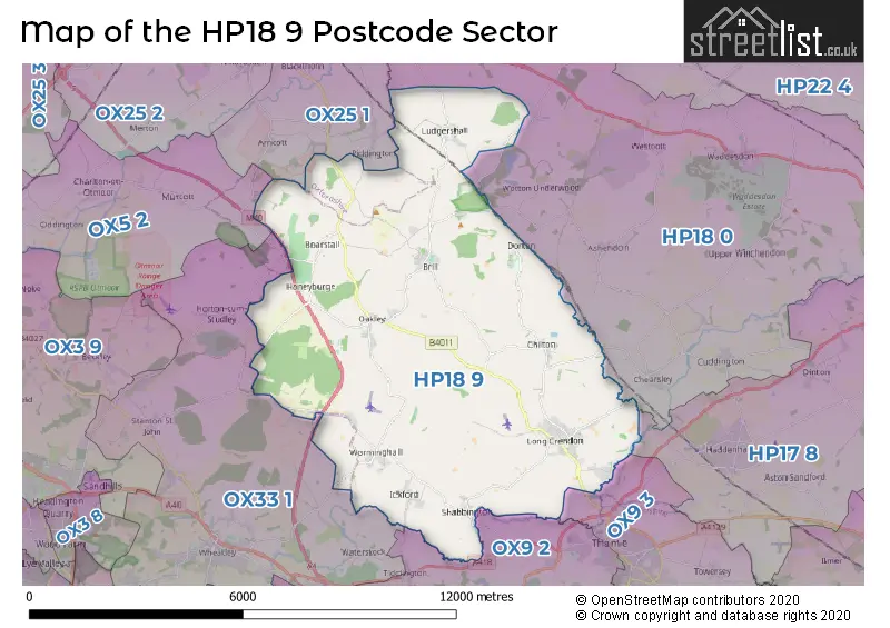
The HP18 9 postcode sector stands on the Buckinghamshire and Oxfordshire border.
Did you know? According to the 2021 Census, the HP18 9 postcode sector is home to a bustling 7,625 residents!
Given that each sector allows for 400 unique postcode combinations. Letters C, I, K, M, O and V are not allowed in the last two letters of a postcode. With 283 postcodes already in use, this leaves 117 units available.
The largest settlement in the HP18 9 postal code is Long Crendon followed by Brill, and Oakley.
The HP18 9 Postcode shares a border with OX5 2 (KIDLINGTON, Charlton On Otmoor, Islip), OX9 2 (THAME, Tiddington, Milton Common), OX9 3 (THAME, Towersey), OX25 1 (Upper Arncott, Piddington, Blackthorn), HP17 8 (Haddenham, Stone, Dinton), HP18 0 (AYLESBURY, Waddesdon, Grendon Underwood) and OX33 1 (Wheatley, Horspath, Horton-cum-Studley).
The sector is within the post town of AYLESBURY.
HP18 9 is a postcode sector within the HP18 postcode district which is within the HP Hemel Hempstead postcode area.
The Royal Mail delivery office for the HP18 9 postal sector is the Aylesbury Vale Postal Delivery Office.
The area of the HP18 9 postcode sector is 34.02 square miles which is 88.11 square kilometres or 21,772.44 square acres.
The HP18 9 postcode sector is crossed by the M40 motorway.
Waterways within the HP18 9 postcode sector include the Thame.

Map of the HP18 9 Postcode Sector
Explore the HP18 9 postcode sector by using our free interactive map.
| H | P | 1 | 8 | - | 9 | X | X |
| H | P | 1 | 8 | Space | 9 | Letter | Letter |
Official List of Streets
Long Crendon (51 Streets)
Oakley (25 Streets)
Brill (26 Streets)
Worminghall (11 Streets)
Ickford (12 Streets)
Chilton (6 Streets)
Ludgershall (11 Streets)
Little Ickford (1 Streets)
Shabbington (14 Streets)
Boarstall (1 Streets)
Dorton (1 Streets)
Unofficial Streets or Alternative Spellings
Long Crendon
BILLWELL WALNUT CLOSELudgershall
WEST VIEWChearsley
CHILTON ROADPiddington
LUDGERSHALL ROADWeather Forecast for HP18 9
Press Button to Show Forecast for Waterperry
| Time Period | Icon | Description | Temperature | Rain Probability | Wind |
|---|---|---|---|---|---|
| 00:00 to 03:00 | Cloudy | 5.0°C (feels like 3.0°C) | 5.00% | ENE 4 mph | |
| 03:00 to 06:00 | Cloudy | 3.0°C (feels like 1.0°C) | 4.00% | ENE 4 mph | |
| 06:00 to 09:00 | Cloudy | 3.0°C (feels like 1.0°C) | 5.00% | ENE 7 mph | |
| 09:00 to 12:00 | Partly cloudy (day) | 7.0°C (feels like 5.0°C) | 3.00% | ENE 9 mph | |
| 12:00 to 15:00 | Cloudy | 10.0°C (feels like 8.0°C) | 9.00% | ENE 7 mph | |
| 15:00 to 18:00 | Overcast | 10.0°C (feels like 9.0°C) | 15.00% | ENE 4 mph | |
| 18:00 to 21:00 | Overcast | 9.0°C (feels like 8.0°C) | 14.00% | NE 4 mph | |
| 21:00 to 00:00 | Cloudy | 6.0°C (feels like 4.0°C) | 13.00% | ENE 7 mph |
Press Button to Show Forecast for Waterperry
| Time Period | Icon | Description | Temperature | Rain Probability | Wind |
|---|---|---|---|---|---|
| 00:00 to 03:00 | Cloudy | 5.0°C (feels like 2.0°C) | 12.00% | ENE 7 mph | |
| 03:00 to 06:00 | Cloudy | 4.0°C (feels like 1.0°C) | 16.00% | ENE 7 mph | |
| 06:00 to 09:00 | Cloudy | 5.0°C (feels like 2.0°C) | 20.00% | ENE 7 mph | |
| 09:00 to 12:00 | Overcast | 8.0°C (feels like 6.0°C) | 22.00% | ENE 9 mph | |
| 12:00 to 15:00 | Cloudy | 11.0°C (feels like 9.0°C) | 17.00% | ENE 11 mph | |
| 15:00 to 18:00 | Cloudy | 12.0°C (feels like 10.0°C) | 19.00% | ENE 11 mph | |
| 18:00 to 21:00 | Light rain | 10.0°C (feels like 8.0°C) | 51.00% | ENE 9 mph | |
| 21:00 to 00:00 | Light rain | 8.0°C (feels like 5.0°C) | 48.00% | NE 11 mph |
Press Button to Show Forecast for Waterperry
| Time Period | Icon | Description | Temperature | Rain Probability | Wind |
|---|---|---|---|---|---|
| 00:00 to 03:00 | Heavy rain | 8.0°C (feels like 5.0°C) | 77.00% | NE 11 mph | |
| 03:00 to 06:00 | Heavy rain | 8.0°C (feels like 5.0°C) | 75.00% | NE 9 mph | |
| 06:00 to 09:00 | Heavy rain | 8.0°C (feels like 6.0°C) | 75.00% | ENE 7 mph | |
| 09:00 to 12:00 | Heavy rain shower (day) | 10.0°C (feels like 8.0°C) | 56.00% | ESE 9 mph | |
| 12:00 to 15:00 | Light rain shower (day) | 11.0°C (feels like 9.0°C) | 44.00% | SSE 9 mph | |
| 15:00 to 18:00 | Light rain shower (day) | 11.0°C (feels like 9.0°C) | 40.00% | W 11 mph | |
| 18:00 to 21:00 | Light rain shower (day) | 10.0°C (feels like 8.0°C) | 35.00% | W 9 mph | |
| 21:00 to 00:00 | Partly cloudy (night) | 8.0°C (feels like 6.0°C) | 4.00% | WSW 7 mph |
Schools and Places of Education Within the HP18 9 Postcode Sector
Brill Church of England School
Academy converter
The Firs, Aylesbury, Buckinghamshire, HP18 9RY
Head: Mrs Louise White
Ofsted Rating: Good
Inspection: 2023-04-20 (372 days ago)
Website: Visit Brill Church of England School Website
Phone: 01844237710
Number of Pupils: 188
Ickford School
Academy converter
Sheldon Road, Aylesbury, Buckinghamshire, HP18 9HY
Head: Mr John Ronane
Ofsted Rating: Good
Inspection: 2021-12-01 (877 days ago)
Website: Visit Ickford School Website
Phone: 01844339261
Number of Pupils: 137
Long Crendon School
Community school
Chilton Road, Aylesbury, Buckinghamshire, HP18 9BZ
Head: Miss Amanda Cook
Ofsted Rating: Requires improvement
Inspection: 2022-06-29 (667 days ago)
Website: Visit Long Crendon School Website
Phone: 01844208225
Number of Pupils: 209
Oakley Church of England Combined School
Voluntary controlled school
Worminghall Road, Aylesbury, Buckinghamshire, HP18 9QY
Head: Mrs Helen Maskell
Ofsted Rating: Good
Inspection: 2019-06-25 (1767 days ago)
Website: Visit Oakley Church of England Combined School Website
Phone: 01844238364
Number of Pupils: 96
House Prices in the HP18 9 Postcode Sector
| Type of Property | 2018 Average | 2018 Sales | 2017 Average | 2017 Sales | 2016 Average | 2016 Sales | 2015 Average | 2015 Sales |
|---|---|---|---|---|---|---|---|---|
| Detached | £712,344 | 45 | £705,565 | 53 | £612,614 | 64 | £668,359 | 52 |
| Semi-Detached | £420,469 | 32 | £448,012 | 26 | £368,518 | 37 | £369,840 | 25 |
| Terraced | £374,844 | 16 | £424,923 | 13 | £371,248 | 22 | £401,321 | 17 |
| Flats | £195,000 | 2 | £169,375 | 4 | £316,800 | 5 | £165,650 | 5 |
Important Postcodes HP18 9 in the Postcode Sector
HP18 9BZ is the postcode for Long Crendon County Combined School, Chilton Road
HP18 9HY is the postcode for Ickford Combined School, Sheldon Road
HP18 9QY is the postcode for Oakley Combined School, Worminghall Road
HP18 9RY is the postcode for BRILL CHURCH OF ENGLAND COMBINED SCHOOL, THE FIRS, BRILL, Brill Church Of England Combined School, The Firs, and Brill C of E Combined School, The Firs
HP18 9SA is the postcode for Doctors Surgery, 22, Thame Road
| The HP18 9 Sector is within these Local Authorities |
|
|---|---|
| The HP18 9 Sector is within these Counties |
|
| The HP18 9 Sector is within these Water Company Areas |
|
Tourist Attractions within the HP18 9 Postcode Area
We found 3 visitor attractions within the HP18 postcode area
| Boarstall Duck Decoy and Nature Reserve |
|---|
| Wildlife |
| Nature Reserve / Wetlands / Wildlife Trips |
| View Boarstall Duck Decoy and Nature Reserve on Google Maps |
| Boarstall Tower |
| Historic Properties |
| Other Historic Property |
| View Boarstall Tower on Google Maps |
| Long Crendon Courthouse |
| Historic Properties |
| Historic House / House and Garden / Palace |
| View Long Crendon Courthouse on Google Maps |