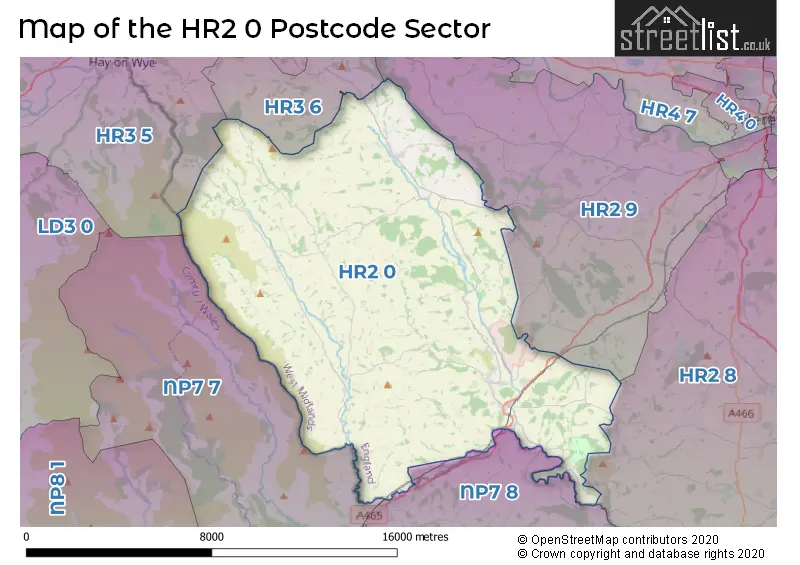
The HR2 0 postcode sector lies where the three counties of Gwent, Herefordshire, and Powys meet.
Did you know? According to the 2021 Census, the HR2 0 postcode sector is home to a bustling 4,250 residents!
Given that each sector allows for 400 unique postcode combinations. Letters C, I, K, M, O and V are not allowed in the last two letters of a postcode. With 246 postcodes already in use, this leaves 154 units available.
The largest settlement in the HR2 0 postal code is Peterchurch followed by Ewyas Harold, and Longtown.
The HR2 0 Postcode shares a border with HR2 8 (St. Weonards, Much Birch, Much Dewchurch), HR2 9 (Madley, Clehonger, Kingstone), HR3 5 (HAY-ON-WYE, GLASBURY, CLYRO), HR3 6 (Eardisley, Whitney-on-Wye, Dorstone), NP7 7 (ABERGAVENNY, LLANWENARTH, CWMYOY) and NP7 8 (GROSMONT, LLANVIHANGEL CRUCORNEY, PANDY).
The sector is within the post town of HEREFORD.
HR2 0 is a postcode sector within the HR2 postcode district which is within the HR Hereford postcode area.
The Royal Mail delivery office for the HR2 0 postal sector is the Hereford Delivery Office and Longtown (hr) Delivery Office and Pontrilas Scale Payment Delivery Office.
The area of the HR2 0 postcode sector is 73.55 square miles which is 190.49 square kilometres or 47,071.36 square acres.
Waterways within the HR2 0 postcode sector include the River Monnow, River Dore.

Map of the HR2 0 Postcode Sector
Explore the HR2 0 postcode sector by using our free interactive map.
| H | R | 2 | - | 0 | X | X |
| H | R | 2 | Space | 0 | Letter | Letter |
Official List of Streets
Ewyas Harold (15 Streets)
Pontrilas (7 Streets)
Longtown (4 Streets)
Peterchurch (13 Streets)
Dulas (1 Streets)
Vowchurch (1 Streets)
Unofficial Streets or Alternative Spellings
Weather Forecast for HR2 0
Press Button to Show Forecast for Abbey Dore Court Garden
| Time Period | Icon | Description | Temperature | Rain Probability | Wind |
|---|---|---|---|---|---|
| 06:00 to 09:00 | Cloudy | 4.0°C (feels like 3.0°C) | 7.00% | NE 4 mph | |
| 09:00 to 12:00 | Cloudy | 7.0°C (feels like 5.0°C) | 7.00% | E 7 mph | |
| 12:00 to 15:00 | Cloudy | 9.0°C (feels like 7.0°C) | 11.00% | E 7 mph | |
| 15:00 to 18:00 | Overcast | 10.0°C (feels like 9.0°C) | 15.00% | E 4 mph | |
| 18:00 to 21:00 | Cloudy | 9.0°C (feels like 8.0°C) | 12.00% | ENE 4 mph | |
| 21:00 to 00:00 | Cloudy | 6.0°C (feels like 4.0°C) | 12.00% | NE 4 mph |
Press Button to Show Forecast for Abbey Dore Court Garden
| Time Period | Icon | Description | Temperature | Rain Probability | Wind |
|---|---|---|---|---|---|
| 00:00 to 03:00 | Cloudy | 4.0°C (feels like 2.0°C) | 13.00% | NE 4 mph | |
| 03:00 to 06:00 | Cloudy | 3.0°C (feels like 1.0°C) | 12.00% | NNE 7 mph | |
| 06:00 to 09:00 | Cloudy | 4.0°C (feels like 1.0°C) | 12.00% | NNE 7 mph | |
| 09:00 to 12:00 | Overcast | 7.0°C (feels like 4.0°C) | 19.00% | NE 9 mph | |
| 12:00 to 15:00 | Overcast | 9.0°C (feels like 7.0°C) | 25.00% | ENE 11 mph | |
| 15:00 to 18:00 | Overcast | 10.0°C (feels like 8.0°C) | 21.00% | NE 11 mph | |
| 18:00 to 21:00 | Overcast | 10.0°C (feels like 7.0°C) | 21.00% | NE 11 mph | |
| 21:00 to 00:00 | Cloudy | 8.0°C (feels like 5.0°C) | 22.00% | NE 11 mph |
Press Button to Show Forecast for Abbey Dore Court Garden
| Time Period | Icon | Description | Temperature | Rain Probability | Wind |
|---|---|---|---|---|---|
| 00:00 to 03:00 | Light rain | 7.0°C (feels like 3.0°C) | 49.00% | NNE 11 mph | |
| 03:00 to 06:00 | Heavy rain | 6.0°C (feels like 3.0°C) | 74.00% | N 11 mph | |
| 06:00 to 09:00 | Light rain | 6.0°C (feels like 2.0°C) | 56.00% | N 13 mph | |
| 09:00 to 12:00 | Light rain | 7.0°C (feels like 4.0°C) | 54.00% | N 13 mph | |
| 12:00 to 15:00 | Light rain shower (day) | 9.0°C (feels like 6.0°C) | 45.00% | N 11 mph | |
| 15:00 to 18:00 | Light rain | 10.0°C (feels like 8.0°C) | 52.00% | NNW 11 mph | |
| 18:00 to 21:00 | Light rain shower (day) | 10.0°C (feels like 8.0°C) | 35.00% | NNW 7 mph | |
| 21:00 to 00:00 | Clear night | 7.0°C (feels like 6.0°C) | 5.00% | WNW 4 mph |
Schools and Places of Education Within the HR2 0 Postcode Sector
Ewyas Harold Primary School
Community school
Ewyas Harold, Hereford, Herefordshire, HR2 0EY
Head: Mr Richard Foster
Ofsted Rating: Requires improvement
Inspection: 2023-10-18 (191 days ago)
Website: Visit Ewyas Harold Primary School Website
Phone: 01981240432
Number of Pupils: 108
Fairfield High School
Academy converter
Peterchurch, Hereford, Herefordshire, HR2 0SG
Head: Mr Paul Jennings
Ofsted Rating: Outstanding
Inspection: 2023-11-29 (149 days ago)
Website: Visit Fairfield High School Website
Phone: 01981550231
Number of Pupils: 555
Longtown Community Primary School
Community school
Longtown, Hereford, Herefordshire, HR2 0LE
Head: Mrs Jane Barnes
Ofsted Rating: Good
Inspection: 2018-09-26 (2039 days ago)
Website: Visit Longtown Community Primary School Website
Phone: 01873860239
Number of Pupils: 65
Michaelchurch Escley Primary School
Community school
Michaelchurch Escley, Hereford, Herefordshire, HR2 0PT
Head: Mrs Louise Crocker
Ofsted Rating: Good
Inspection: 2022-12-02 (511 days ago)
Website: Visit Michaelchurch Escley Primary School Website
Phone: 01981510208
Number of Pupils: 62
Peterchurch Primary School
Community school
Peterchurch, Hereford, Herefordshire, HR2 0RP
Head: Mrs Nia Powell
Ofsted Rating: Good
Inspection: 2022-03-16 (772 days ago)
Website: Visit Peterchurch Primary School Website
Phone: 01981550230
Number of Pupils: 87
House Prices in the HR2 0 Postcode Sector
| Type of Property | 2018 Average | 2018 Sales | 2017 Average | 2017 Sales | 2016 Average | 2016 Sales | 2015 Average | 2015 Sales |
|---|---|---|---|---|---|---|---|---|
| Detached | £367,000 | 28 | £377,297 | 37 | £325,851 | 37 | £325,887 | 31 |
| Semi-Detached | £201,413 | 12 | £198,850 | 7 | £179,000 | 9 | £184,875 | 8 |
| Terraced | £159,286 | 7 | £163,056 | 9 | £130,807 | 13 | £124,000 | 9 |
| Flats | £0 | 0 | £91,000 | 1 | £0 | 0 | £0 | 0 |
Important Postcodes HR2 0 in the Postcode Sector
HR2 0EY is the postcode for Ewyas Harold Primary School, Ewyas Harold
HR2 0LD is the postcode for Northamptonshire County Council, Longtown Outdoor Education Centre, and BLOCK B, Northamptonshire County Council, Longtown Outdoor Education Centre
HR2 0PT is the postcode for Michaelchurch Escley Primary School, Michaelchurch Escley
HR2 0RP is the postcode for Peterchurch Primary School, Peterchurch
HR2 0SG is the postcode for Fairfield High School, Peterchurch
| The HR2 0 Sector is within these Local Authorities |
|
|---|---|
| The HR2 0 Sector is within these Counties |
|
| The HR2 0 Sector is within these Water Company Areas |
|