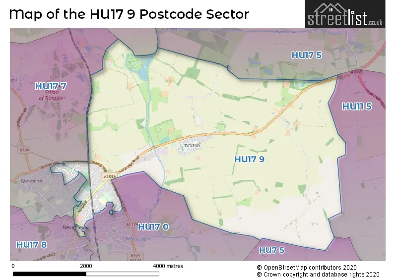
The HU17 9 postcode sector is within the county of East Riding of Yorkshire.
Did you know? According to the 2021 Census, the HU17 9 postcode sector is home to a bustling 9,970 residents!
Given that each sector allows for 400 unique postcode combinations. Letters C, I, K, M, O and V are not allowed in the last two letters of a postcode. With 225 postcodes already in use, this leaves 175 units available.
The largest settlement in the HU17 9 postal code is BEVERLEY followed by Tickton, and Routh.
The HU17 9 Postcode shares a border with YO25 9 (Cranswick, Middleton On The Wolds, Wetwang), HU7 5 (Bransholme, Wawne, Sutton-on-Hull), HU11 5 (Skirlaugh, Seaton, Long Riston), HU17 0 (BEVERLEY, Woodmansey, Weel), HU17 5 (Leven, Catwick), HU17 7 (BEVERLEY, Leconfield, Cherry Burton) and HU17 8 (BEVERLEY, Walkington, Bishop Burton).
The sector is within the post town of BEVERLEY.
HU17 9 is a postcode sector within the HU17 postcode district which is within the HU Hull postcode area.
The Royal Mail delivery office for the HU17 9 postal sector is the Beverley Delivery Office.
The area of the HU17 9 postcode sector is 11.33 square miles which is 29.33 square kilometres or 7,248.48 square acres.
Waterways within the HU17 9 postcode sector include the River Hull, Beverley and Barmston Drain, Holderness Drain.

Map of the HU17 9 Postcode Sector
Explore the HU17 9 postcode sector by using our free interactive map.
| H | U | 1 | 7 | - | 9 | X | X |
| H | U | 1 | 7 | Space | 9 | Letter | Letter |
Official List of Streets
BEVERLEY (114 Streets)
Tickton (20 Streets)
Routh (2 Streets)
Unofficial Streets or Alternative Spellings
Wawne
MEAUX ROADWeel
CARR LANEBEVERLEY
ARDEN ROAD BUTCHER ROW CHERRY TREE LANE DANESWAY DYER LANE GLOBE MEWS HENGATE HODGSON AVENUE KNIGHTS WAY LANDRESS LANE MANOR ROAD MILL LANE COURT NEVILLE AVENUE NOLLOTH CRESCENT OAK TREE DRIVE PIGHILL LANE SAMMAN ROAD SAXON RISE SCRUBWOOD LANE SOW HILL ROAD SWINEMOOR LANE THURLOW AVENUE WILBERFORCE CRESCENT WILBERT LANE WINDMILL WALK WOODHALL PARK WOODHALL WAYArram
CHAPEL GARTHWeather Forecast for HU17 9
Press Button to Show Forecast for Leconfield Sar
| Time Period | Icon | Description | Temperature | Rain Probability | Wind |
|---|---|---|---|---|---|
| 18:00 to 21:00 | Partly cloudy (day) | 16.0°C (feels like 15.0°C) | 4.00% | E 9 mph | |
| 21:00 to 00:00 | Clear night | 12.0°C (feels like 11.0°C) | 1.00% | E 4 mph |
Press Button to Show Forecast for Leconfield Sar
| Time Period | Icon | Description | Temperature | Rain Probability | Wind |
|---|---|---|---|---|---|
| 00:00 to 03:00 | Clear night | 11.0°C (feels like 10.0°C) | 1.00% | NE 2 mph | |
| 03:00 to 06:00 | Clear night | 9.0°C (feels like 9.0°C) | 4.00% | NE 2 mph | |
| 06:00 to 09:00 | Sunny day | 12.0°C (feels like 12.0°C) | 1.00% | E 2 mph | |
| 09:00 to 12:00 | Sunny day | 18.0°C (feels like 17.0°C) | 1.00% | SSE 7 mph | |
| 12:00 to 15:00 | Sunny day | 21.0°C (feels like 20.0°C) | 7.00% | S 9 mph | |
| 15:00 to 18:00 | Cloudy | 22.0°C (feels like 19.0°C) | 12.00% | SSE 11 mph | |
| 18:00 to 21:00 | Cloudy | 19.0°C (feels like 18.0°C) | 8.00% | SE 9 mph | |
| 21:00 to 00:00 | Cloudy | 16.0°C (feels like 15.0°C) | 4.00% | SE 7 mph |
Press Button to Show Forecast for Leconfield Sar
| Time Period | Icon | Description | Temperature | Rain Probability | Wind |
|---|---|---|---|---|---|
| 00:00 to 03:00 | Cloudy | 14.0°C (feels like 13.0°C) | 5.00% | SE 7 mph | |
| 03:00 to 06:00 | Cloudy | 13.0°C (feels like 12.0°C) | 8.00% | ESE 7 mph | |
| 06:00 to 09:00 | Cloudy | 14.0°C (feels like 12.0°C) | 11.00% | ESE 7 mph | |
| 09:00 to 12:00 | Light rain | 16.0°C (feels like 14.0°C) | 45.00% | ESE 9 mph | |
| 12:00 to 15:00 | Light rain | 17.0°C (feels like 15.0°C) | 44.00% | ESE 11 mph | |
| 15:00 to 18:00 | Cloudy | 18.0°C (feels like 16.0°C) | 14.00% | SE 11 mph | |
| 18:00 to 21:00 | Light rain | 16.0°C (feels like 15.0°C) | 42.00% | SE 9 mph | |
| 21:00 to 00:00 | Cloudy | 14.0°C (feels like 13.0°C) | 13.00% | SE 4 mph |
Press Button to Show Forecast for Leconfield Sar
| Time Period | Icon | Description | Temperature | Rain Probability | Wind |
|---|---|---|---|---|---|
| 00:00 to 03:00 | Cloudy | 13.0°C (feels like 12.0°C) | 7.00% | SE 4 mph | |
| 03:00 to 06:00 | Cloudy | 12.0°C (feels like 11.0°C) | 5.00% | SE 4 mph | |
| 06:00 to 09:00 | Cloudy | 13.0°C (feels like 12.0°C) | 7.00% | ESE 4 mph | |
| 09:00 to 12:00 | Cloudy | 15.0°C (feels like 14.0°C) | 11.00% | ESE 7 mph | |
| 12:00 to 15:00 | Cloudy | 16.0°C (feels like 15.0°C) | 14.00% | ESE 9 mph | |
| 15:00 to 18:00 | Light rain shower (day) | 17.0°C (feels like 16.0°C) | 30.00% | ESE 9 mph | |
| 18:00 to 21:00 | Cloudy | 15.0°C (feels like 14.0°C) | 13.00% | E 7 mph | |
| 21:00 to 00:00 | Cloudy | 13.0°C (feels like 12.0°C) | 4.00% | E 4 mph |
Press Button to Show Forecast for Leconfield Sar
| Time Period | Icon | Description | Temperature | Rain Probability | Wind |
|---|---|---|---|---|---|
| 00:00 to 03:00 | Cloudy | 11.0°C (feels like 11.0°C) | 5.00% | E 2 mph | |
| 03:00 to 06:00 | Cloudy | 10.0°C (feels like 10.0°C) | 7.00% | ENE 2 mph | |
| 06:00 to 09:00 | Mist | 12.0°C (feels like 11.0°C) | 15.00% | ENE 2 mph | |
| 09:00 to 12:00 | Cloudy | 15.0°C (feels like 15.0°C) | 6.00% | SSW 4 mph | |
| 12:00 to 15:00 | Cloudy | 18.0°C (feels like 17.0°C) | 8.00% | ESE 7 mph | |
| 15:00 to 18:00 | Cloudy | 17.0°C (feels like 16.0°C) | 12.00% | ENE 9 mph | |
| 18:00 to 21:00 | Cloudy | 15.0°C (feels like 14.0°C) | 10.00% | E 7 mph | |
| 21:00 to 00:00 | Cloudy | 12.0°C (feels like 12.0°C) | 7.00% | NE 4 mph |
Schools and Places of Education Within the HU17 9 Postcode Sector
Beverley High School
Community school
Norwood, Beverley, , HU17 9EX
Head: Ms S Japp
Ofsted Rating: Outstanding
Inspection: 2021-11-17 (907 days ago)
Website: Visit Beverley High School Website
Phone: 01482881658
Number of Pupils: 847
Swinemoor Primary School
Community school
Burden Road, Beverley, , HU17 9LW
Head: Leon Myers
Ofsted Rating: Outstanding
Inspection: 2023-01-11 (487 days ago)
Website: Visit Swinemoor Primary School Website
Phone: 01482869247
Number of Pupils: 238
Tickton Church of England Voluntary Controlled Primary School
Voluntary controlled school
Main Street, Beverley, , HU17 9RZ
Head: Miss Chris Brown
Ofsted Rating: Good
Inspection: 2019-11-07 (1648 days ago)
Website: Visit Tickton Church of England Voluntary Controlled Primary School Website
Phone: 01964542498
Number of Pupils: 181
House Prices in the HU17 9 Postcode Sector
| Type of Property | 2018 Average | 2018 Sales | 2017 Average | 2017 Sales | 2016 Average | 2016 Sales | 2015 Average | 2015 Sales |
|---|---|---|---|---|---|---|---|---|
| Detached | £266,905 | 49 | £251,083 | 53 | £254,347 | 49 | £248,079 | 65 |
| Semi-Detached | £171,297 | 67 | £157,931 | 63 | £165,246 | 60 | £153,872 | 73 |
| Terraced | £165,610 | 45 | £150,438 | 61 | £139,307 | 49 | £146,637 | 50 |
| Flats | £137,328 | 9 | £253,650 | 5 | £124,684 | 16 | £102,895 | 11 |
Important Postcodes HU17 9 in the Postcode Sector
HU17 9AX is the postcode for Beverley CSC, 7 Cross Street
HU17 9BA is the postcode for BLOCKS A,B,C,F,G,H AND J, East Riding of Yorkshire Council, County Hall, Cross Street, BLOCK K, East Riding of Yorkshire Council, County Hall, Cross Street, BLOCK X FILING AND DESPATCH OFFICE, East Riding of Yorkshire Council, County Hall, Cross Street, BLOCKS D AND M, East Riding of Yorkshire Council, County Hall, Cross Street, BLOCK E, East Riding of Yorkshire Council, County Hall, Cross Street, and East Riding of Yorkshire Council, County Hall, Cross Street
HU17 9BP is the postcode for East Riding Register Office, Walkergate House, Walkergate
HU17 9DH is the postcode for Mill Lane Residential Centre, 92 Mill Lane
HU17 9EH is the postcode for East Riding of Yorkshire Council, The Old School House, New Walkergate, and East Riding of Yorkshire Council, The Old School House
HU17 9EJ is the postcode for Beverley MagistratesG�� Court and Hearing Centre, The Court House, Champney Road, and East Yorkshire Magistrates Court, Champney Road
HU17 9EQ is the postcode for OCCUPATIONAL HEALTH AND WELL-BEING CENTRE, Humberside Fire & Rescue Service, Fire Station, New Walkergate, Humberside Fire & Rescue Service, Fire Station, New Walkergate, and FIRE STATION (BLOCK A), Humberside Fire & Rescue Service, Fire Station, New Walkergate
HU17 9EX is the postcode for TEACHING BLOCK F, Beverley High School, Norwood, TEACHING AND GYM BLOCK, Beverley High School, Norwood, TEACHING BLOCK E, Beverley High School, Norwood, SIXTH FORM BLOCK, Beverley High School, Norwood, TECHNOLOGY BLOCK, Beverley High School, Norwood, SPORTS HALL, Beverley High School, Norwood, SPORTS HALL SPORTS HALL, Beverley High School, Norwood, Beverley High School, Norwood, TEACHING KITCHEN & DINING, Beverley High School, Norwood, and SCIENCE BLOCK, Beverley High School, Norwood
HU17 9JB is the postcode for Department for Environment, Food & Rural Affairs (DEFRA), Crosskill House, Mill Lane, Department of Environment Food & Rural Affairs, Crosskill House, Mill Lane, and Department for Environment, Food & Rural Affairs (DEFRA, Crosskill House, Mill Lane
HU17 9LP is the postcode for East Yorkshire Community Health Care NHS Trust, Coltman Avenue Clinic, Coltman Avenue, Beverley Swinemoor Childrens Centre, Coltman Avenue, and Hexagon Music Centre, Coltman Avenue
HU17 9LW is the postcode for Swinemoor School, Burden Road, and Beverley Youth Centre, Burden Road
HU17 9RZ is the postcode for Tickton C Of E Primary School, Main Street, and Tickton C of E VC Primary School, Main Street
HU17 9XX is the postcode for Beverley Guidhall, Register Square
| The HU17 9 Sector is within these Local Authorities |
|
|---|---|
| The HU17 9 Sector is within these Counties |
|
| The HU17 9 Sector is within these Water Company Areas |
|