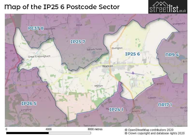
The IP25 6 postcode sector is within the county of Norfolk.
Did you know? According to the 2021 Census, the IP25 6 postcode sector is home to a bustling 14,310 residents!
Given that each sector allows for 400 unique postcode combinations. Letters C, I, K, M, O and V are not allowed in the last two letters of a postcode. With 373 postcodes already in use, this leaves 27 units available.
The largest settlement in the IP25 6 postal code is Watton followed by Carbrooke, and Griston.
The IP25 6 Postcode shares a border with NR9 4 (Hingham, Barnham Broom, Barford), NR17 1 (ATTLEBOROUGH, Old Buckenham, Great Ellingham), PE37 8 (SWAFFHAM, Necton, North Pickenham), IP24 1 (THETFORD, Great Hockham, Wretham), IP25 7 (Shipdham, Ashill, Saham Toney) and IP26 5 (Mundford, Northwold, Foulden).
The sector is within the post town of THETFORD.
IP25 6 is a postcode sector within the IP25 postcode district which is within the IP Ipswich postcode area.
The Royal Mail delivery office for the IP25 6 postal sector is the Thetford Delivery Office and Watton Scale Payment Delivery Office.
The area of the IP25 6 postcode sector is 26.71 square miles which is 69.18 square kilometres or 17,095.54 square acres.

Map of the IP25 6 Postcode Sector
Explore the IP25 6 postcode sector by using our free interactive map.
| I | P | 2 | 5 | - | 6 | X | X |
| I | P | 2 | 5 | Space | 6 | Letter | Letter |
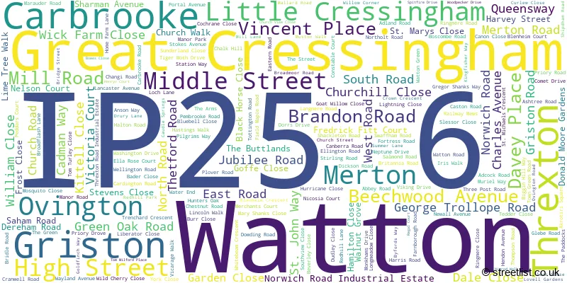
Official List of Streets
Watton (183 Streets)
Carbrooke (41 Streets)
Griston (21 Streets)
Threxton (1 Streets)
Merton (3 Streets)
Ovington (6 Streets)
Great Cressingham (8 Streets)
Little Cressingham (4 Streets)
Unofficial Streets or Alternative Spellings
Shipdham
CARBROOKE LANE KING ROWCranworth
MOOR LANECaston
CARBROOKE ROAD THE STREET CAUDLE HILL CHASTON PLACE CHURCHVIEW CLOSE CLARENCE COURT CROWS LANE CUCKOO LANE ELWORTHY CLOSE FAIRSTEAD LANE FAIRWAY DRIVE FEN ROAD GILLMANS DRIFT GREAT CRESSINGHAM ROAD HALL ALLEY HALTON GARDENS HOME LANE HORSE SHOE CLOSE LAY BY LINMORE COURT LINMORE CRESCENT LOW COMMON LANE MARSTON WALK MEMORIAL WAY SAHAM TONEY ROAD SAINT GILES ROAD SAINT JOHN WAY SAINT MARYS CLOSE SAINT MICHAELS CRESCENT SCHOOL ROAD SOUTH PICKENHAM ROAD SOUTHWATER LANE STANS WALK THE BULL YARD THREXTON ROAD TOTTINGTON TERRACE WEST END COURT WILLOW LANE WISSEY GROVE WOOD LANESaham Toney
OVINGTON ROAD THREXTON ROADAshill
CRESSINGHAM ROADThompson
GRISTON ROAD WATTON ROADIckburgh
SWAFFHAM ROADWeather Forecast for IP25 6
Press Button to Show Forecast for Watton
| Time Period | Icon | Description | Temperature | Rain Probability | Wind |
|---|---|---|---|---|---|
| 21:00 to 00:00 | Partly cloudy (night) | 5.0°C (feels like 3.0°C) | 1.00% | ENE 7 mph |
Press Button to Show Forecast for Watton
| Time Period | Icon | Description | Temperature | Rain Probability | Wind |
|---|---|---|---|---|---|
| 00:00 to 03:00 | Partly cloudy (night) | 4.0°C (feels like 2.0°C) | 2.00% | ENE 7 mph | |
| 03:00 to 06:00 | Cloudy | 4.0°C (feels like 2.0°C) | 9.00% | NE 7 mph | |
| 06:00 to 09:00 | Overcast | 6.0°C (feels like 3.0°C) | 51.00% | NE 7 mph | |
| 09:00 to 12:00 | Light rain | 7.0°C (feels like 5.0°C) | 55.00% | ENE 9 mph | |
| 12:00 to 15:00 | Overcast | 8.0°C (feels like 5.0°C) | 22.00% | NE 11 mph | |
| 15:00 to 18:00 | Overcast | 9.0°C (feels like 6.0°C) | 12.00% | NE 11 mph | |
| 18:00 to 21:00 | Overcast | 9.0°C (feels like 6.0°C) | 11.00% | NE 11 mph | |
| 21:00 to 00:00 | Cloudy | 8.0°C (feels like 5.0°C) | 14.00% | NE 11 mph |
Press Button to Show Forecast for Watton
| Time Period | Icon | Description | Temperature | Rain Probability | Wind |
|---|---|---|---|---|---|
| 00:00 to 03:00 | Heavy rain | 8.0°C (feels like 5.0°C) | 85.00% | NNE 11 mph | |
| 03:00 to 06:00 | Heavy rain | 8.0°C (feels like 5.0°C) | 87.00% | NNE 11 mph | |
| 06:00 to 09:00 | Heavy rain | 9.0°C (feels like 7.0°C) | 87.00% | ENE 9 mph | |
| 09:00 to 12:00 | Heavy rain shower (day) | 9.0°C (feels like 7.0°C) | 63.00% | W 9 mph | |
| 12:00 to 15:00 | Light rain | 10.0°C (feels like 7.0°C) | 58.00% | WNW 11 mph | |
| 15:00 to 18:00 | Light rain shower (day) | 9.0°C (feels like 7.0°C) | 43.00% | W 11 mph | |
| 18:00 to 21:00 | Cloudy | 9.0°C (feels like 7.0°C) | 13.00% | WSW 7 mph | |
| 21:00 to 00:00 | Cloudy | 7.0°C (feels like 5.0°C) | 7.00% | SW 7 mph |
Press Button to Show Forecast for Watton
| Time Period | Icon | Description | Temperature | Rain Probability | Wind |
|---|---|---|---|---|---|
| 00:00 to 03:00 | Cloudy | 6.0°C (feels like 4.0°C) | 6.00% | SW 7 mph | |
| 03:00 to 06:00 | Clear night | 5.0°C (feels like 3.0°C) | 1.00% | SSW 7 mph | |
| 06:00 to 09:00 | Sunny day | 6.0°C (feels like 4.0°C) | 1.00% | S 7 mph | |
| 09:00 to 12:00 | Partly cloudy (day) | 11.0°C (feels like 9.0°C) | 1.00% | S 9 mph | |
| 12:00 to 15:00 | Cloudy | 14.0°C (feels like 11.0°C) | 8.00% | S 11 mph | |
| 15:00 to 18:00 | Partly cloudy (day) | 14.0°C (feels like 12.0°C) | 3.00% | S 11 mph | |
| 18:00 to 21:00 | Sunny day | 12.0°C (feels like 11.0°C) | 2.00% | SSE 9 mph | |
| 21:00 to 00:00 | Clear night | 9.0°C (feels like 7.0°C) | 1.00% | SE 9 mph |
Press Button to Show Forecast for Watton
| Time Period | Icon | Description | Temperature | Rain Probability | Wind |
|---|---|---|---|---|---|
| 00:00 to 03:00 | Clear night | 7.0°C (feels like 5.0°C) | 2.00% | SE 7 mph | |
| 03:00 to 06:00 | Clear night | 7.0°C (feels like 5.0°C) | 4.00% | ESE 7 mph | |
| 06:00 to 09:00 | Partly cloudy (day) | 9.0°C (feels like 7.0°C) | 4.00% | ESE 7 mph | |
| 09:00 to 12:00 | Cloudy | 13.0°C (feels like 12.0°C) | 8.00% | ESE 9 mph | |
| 12:00 to 15:00 | Cloudy | 15.0°C (feels like 13.0°C) | 12.00% | SE 9 mph | |
| 15:00 to 18:00 | Cloudy | 16.0°C (feels like 14.0°C) | 8.00% | SE 9 mph | |
| 18:00 to 21:00 | Cloudy | 14.0°C (feels like 13.0°C) | 6.00% | ESE 9 mph | |
| 21:00 to 00:00 | Overcast | 11.0°C (feels like 10.0°C) | 18.00% | E 7 mph |
Schools and Places of Education Within the IP25 6 Postcode Sector
St Peter and St Paul Church of England Primary Academy & Nursery
Academy converter
Church Street, Thetford, Norfolk, IP25 6SW
Head: Mrs Hannah Wheeler
Ofsted Rating: Good
Inspection: 2019-10-03 (1667 days ago)
Website: Visit St Peter and St Paul Church of England Primary Academy & Nursery Website
Phone: 01953881537
Number of Pupils: 195
Watton Westfield Infant and Nursery School
Academy sponsor led
West Road, Thetford, Norfolk, IP25 6AU
Head: Mrs Helen Kemp
Ofsted Rating: Good
Inspection: 2020-02-27 (1520 days ago)
Website: Visit Watton Westfield Infant and Nursery School Website
Phone: 01953882669
Number of Pupils: 290
Wayland Academy
Academy converter
Merton Road, Thetford, Norfolk, IP25 6BA
Head: Mr Glen Allott
Ofsted Rating: Good
Inspection: 2023-07-12 (289 days ago)
Website: Visit Wayland Academy Website
Phone: 01953881514
Number of Pupils: 576
House Prices in the IP25 6 Postcode Sector
| Type of Property | 2018 Average | 2018 Sales | 2017 Average | 2017 Sales | 2016 Average | 2016 Sales | 2015 Average | 2015 Sales |
|---|---|---|---|---|---|---|---|---|
| Detached | £250,900 | 139 | £263,102 | 178 | £236,055 | 160 | £226,237 | 144 |
| Semi-Detached | £187,672 | 88 | £178,374 | 58 | £166,845 | 70 | £156,438 | 78 |
| Terraced | £155,218 | 86 | £154,733 | 92 | £143,429 | 97 | £139,626 | 95 |
| Flats | £115,667 | 6 | £131,141 | 7 | £114,136 | 22 | £108,009 | 7 |
Important Postcodes IP25 6 in the Postcode Sector
IP25 6AL is the postcode for BLOCK 1, Wayland Junior Academy, Brandon Road, Wayland Junior Academy, Brandon Road, and BLOCK 2, Wayland Junior Academy, Brandon Road
IP25 6AS is the postcode for Norfolk County Council, Watton Library, George Trollope Road
IP25 6AU is the postcode for MAIN BLOCK, Watton Westfield Infant & Nursery School, West Road, INFANT SCHOOL, Watton Westfield Infant & Nursery School, West Road, and NEW CLASSROOM BLOCK, Watton Westfield Infant & Nursery School, West Road
IP25 6BA is the postcode for SOLAR SUITE / SRB, Wayland Academy, Merton Road, SPORTS HALL, Wayland Academy, Merton Road, DESIGN & TECHNOLOGY BLOCK (VOCATIONAL), Wayland Academy, Merton Road, ART BLOCK, Wayland Academy, Merton Road, CDT BLOCK, Wayland Academy, Merton Road, and MAIN BUILDING, Wayland Academy, Merton Road
IP25 6ET is the postcode for Linden Court, Church Walk, and LINDEN COURT, CHURCH WALK, WATTON
IP25 6FA is the postcode for Watton Medical Practice, 24 Gregor Shanks Way
IP25 6RL is the postcode for H M Prison Wayland, Griston, and VISITS HALL HMP WAYLAND, H M Prison Wayland, Griston
IP25 6SW is the postcode for St. Peter & St. Paul VC School, Church Street
| The IP25 6 Sector is within these Local Authorities |
|
|---|---|
| The IP25 6 Sector is within these Counties |
|
| The IP25 6 Sector is within these Water Company Areas |
|