
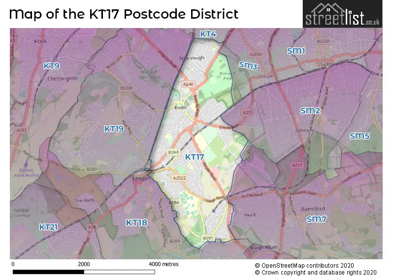
Map of the Postcode District
Explore the postcode district by using our interactive map.
Circles represent recorded crime; the larger the circle, the higher the crime rates.
Your support helps keep this site running!
If you enjoy using this website, consider buying me a coffee to help cover hosting costs.
The postcode district located in the KT Kingston upon Thames postal area , KT17 has a population of 25,655 residents according to the 2021 England and Wales Census.
The area of the district is 3.97 square miles (10.28 square kilometers or 2,540.35 acres).
Where is the KT17 District?
To give you an idea where the district is located we have created the following table showing nearby towns.
Nearest Towns to KT17
| Town | Distance (miles) | Direction |
|---|---|---|
| Epsom | 1.11 | WSW |
| Banstead | 2.13 | SE |
| Leatherhead | 4.85 | SW |
| Esher | 5.64 | WNW |
| Reigate | 7.29 | SSE |
| Redhill | 7.59 | SSE |
| Walton-on-Thames | 8.16 | WNW |
| Caterham | 8.22 | ESE |
| Dorking | 8.31 | SSW |
| Warlingham | 8.40 | ESE |
| Sunbury-on-Thames | 9.29 | NW |
| Weybridge | 9.57 | WNW |
| Addlestone | 10.98 | W |
| Ashford | 11.40 | NW |
| Chertsey | 11.80 | WNW |
| Oxted | 11.86 | ESE |
| Horley | 12.16 | SSE |
| City of Westminster | 12.22 | NNE |
| Staines-upon-Thames | 13.27 | WNW |
The post town for this district is EPSOM.
Postcode Information for District KT17 (Total Geographical Postcodes: 1379)
| Location | Post Town | Sector | Number of Postcodes |
|---|---|---|---|
| EPSOM | EPSOM | KT17 1 | 379 |
| EPSOM | EPSOM | KT17 4 | 307 |
| EPSOM | EPSOM | KT17 2 | 279 |
| EPSOM | EPSOM | KT17 3 | 276 |
| Ewell | EPSOM | KT17 1 | 74 |
| Ewell | EPSOM | KT17 2 | 64 |
Retail and Shopping in KT17
Street
Town
Locality
Number of Shops
Central Postcode
View on Google Maps
STONELEIGH BROADWAY
EPSOM
62
KT17 2HU
View on Google Maps
HIGH STREET
EPSOM
EWELL
50
KT17 1RQ
View on Google Maps
UPPER HIGH STREET
EPSOM
36
KT17 4QY
View on Google Maps
EAST STREET
EPSOM
17
KT17 1BD
View on Google Maps
EWELL BY PASS
EPSOM
14
KT17 2PR
View on Google Maps
EPSOM ROAD
EPSOM
11
KT17 1NX
View on Google Maps
FIR TREE ROAD
EPSOM
11
KT17 3LB
View on Google Maps
KILN LANE
EPSOM
9
KT17 1EQ
View on Google Maps
CHEAM ROAD
EPSOM
7
KT17 1SP
View on Google Maps
THE QUADRANT
EPSOM
6
KT17 4RH
View on Google Maps
| Street | Town | Locality | Number of Shops | Central Postcode | View on Google Maps |
|---|---|---|---|---|---|
| STONELEIGH BROADWAY | EPSOM | 62 | KT17 2HU | View on Google Maps | |
| HIGH STREET | EPSOM | EWELL | 50 | KT17 1RQ | View on Google Maps |
| UPPER HIGH STREET | EPSOM | 36 | KT17 4QY | View on Google Maps | |
| EAST STREET | EPSOM | 17 | KT17 1BD | View on Google Maps | |
| EWELL BY PASS | EPSOM | 14 | KT17 2PR | View on Google Maps | |
| EPSOM ROAD | EPSOM | 11 | KT17 1NX | View on Google Maps | |
| FIR TREE ROAD | EPSOM | 11 | KT17 3LB | View on Google Maps | |
| KILN LANE | EPSOM | 9 | KT17 1EQ | View on Google Maps | |
| CHEAM ROAD | EPSOM | 7 | KT17 1SP | View on Google Maps | |
| THE QUADRANT | EPSOM | 6 | KT17 4RH | View on Google Maps |
The primary settlement in the KT17 postcode district is Epsom, which is located in the county of Surrey in England. Other significant settlements in the district include Ewell. The post town for the KT17 postcode district is Epsom, which is also located in the county of Surrey in England.
When it comes to local government, postal geography often disregards political borders. However, this district intersects the following councils: the district mostly encompasses the Epsom and Ewell District (B) (682 postal codes), followed by the Reigate and Banstead District (B) area (56 postal codes), and finally, the Sutton London Boro area (8 postal codes).
The largest settlement in the KT17 postal code is EWELL followed by EPSOM, and STONELEIGH.
The KT17 Postcode shares a border with KT19 (EPSOM, WEST EWELL, EWELL), KT18 (EPSOM, EPSOM DOWNS) and SM7 (BANSTEAD, WOODMANSTERNE).


Schools in the Sector
Glyn School
Phase: Secondary
Address: The Kingsway , Ewell , Epsom
Postcode: KT17 1NB
Headteacher: Mrs Jo Garrod (Headteacher)
Ofsted Rating: Outstanding
St Clement's Catholic Primary School
Phase: Primary
Address: Fennells Mead , Chessington Road , Ewell , Epsom
Postcode: KT17 1TX
Headteacher: Mrs Irma Chappell (Headteacher)
Ofsted Rating: Good
Ewell Grove Primary and Nursery School
Phase: Primary
Address: West Street , Ewell , Epsom
Postcode: KT17 1UZ
Headteacher: Mrs Kate Keane (Headteacher)
Ofsted Rating: Good
Nonsuch Primary School
Phase: Primary
Address: Chadacre Road , Stoneleigh , Epsom
Postcode: KT17 2HQ
Headteacher: Mrs Caroline Piper (Headteacher)
Ofsted Rating: Good
Meadow Primary School
Phase: Primary
Address: Sparrow Farm Road , Stoneleigh , Epsom
Postcode: KT17 2LW
Headteacher: Ms G Jenkins (Head Teacher)
Ofsted Rating: Good
Meadow Primary School
Phase: Primary
Address: Sparrow Farm Road , Stoneleigh , Epsom
Postcode: KT17 2LW
Headteacher: Ms Laura Benardout (Head Teacher)
Ofsted Rating: Good
Wallace Fields Infant School
Phase: Primary
Address: Wallace Fields , Ewell , Epsom
Postcode: KT17 3AS
Headteacher: Miss N Mann (Headteacher)
Ofsted Rating: Outstanding
Wallace Fields Infant School and Nursery
Phase: Primary
Address: Wallace Fields , Ewell , Epsom
Postcode: KT17 3AS
Headteacher: Mrs Katie Muir (Headteacher)
Ofsted Rating: Outstanding
Wallace Fields Junior School
Phase: Primary
Address: Dorling Drive , Ewell , Epsom
Postcode: KT17 3BH
Headteacher: Mr Steve Lee (Headteacher)
Ofsted Rating: Good
North East Surrey College of Technology
Phase: 16 plus
Address: Reigate Road , Ewell , Epsom
Postcode: KT17 3DS
Headteacher: Mrs Julie Kapsalis (Principal & Chief Exec)
Ofsted Rating: Good
Stations in the Sector
Epsom Downs
CRS Code: EPD
Operator: SN
Line: Epsom Downs Branch
Company: Southern
Ewell East
CRS Code: EWE
Operator: SN
Line: Sutton & Mole Valley Lines
Company: Southern
Stoneleigh
CRS Code: SNL
Operator: SW
Line: Sutton & Mole Valley Lines
Company: South Western Railway
Ewell West
CRS Code: EWW
Operator: SW
Line: Sutton & Mole Valley Lines
Company: South Western Railway
Accessable Motorway Junctions
M25 J9
Average Driving Time from within the district: 10.10
Average Driving Distance: 5.28
Number of Postcodes that can access the Motorway Junction: 750
M25 J8
Average Driving Time from within the district: 12.11
Average Driving Distance: 6.79
Number of Postcodes that can access the Motorway Junction: 750
M25 J7
Average Driving Time from within the district: 15.19
Average Driving Distance: 8.96
Number of Postcodes that can access the Motorway Junction: 750
M23 J8
Average Driving Time from within the district: 15.43
Average Driving Distance: 9.11
Number of Postcodes that can access the Motorway Junction: 717
M3 J1
Average Driving Time from within the district: 20.42
Average Driving Distance: 11.41
Number of Postcodes that can access the Motorway Junction: 33
Weather Forecast for Epsom
| Time Period | Icon | Description | Temperature | Rain Probability | Wind |
|---|---|---|---|---|---|
| 12:00 to 15:00 | Cloudy | 14.0°C (feels like 12.0°C) | 38.00% | SW 11 mph | |
| 15:00 to 18:00 | Cloudy | 15.0°C (feels like 14.0°C) | 7.00% | SW 9 mph | |
| 18:00 to 21:00 | Clear night | 12.0°C (feels like 12.0°C) | 1.00% | SSW 4 mph | |
| 21:00 to 00:00 | Clear night | 11.0°C (feels like 10.0°C) | 0.00% | SW 4 mph |
| Time Period | Icon | Description | Temperature | Rain Probability | Wind |
|---|---|---|---|---|---|
| 00:00 to 03:00 | Clear night | 10.0°C (feels like 9.0°C) | 3.00% | SSW 4 mph | |
| 03:00 to 06:00 | Fog | 9.0°C (feels like 8.0°C) | 14.00% | SSW 4 mph | |
| 06:00 to 09:00 | Fog | 9.0°C (feels like 8.0°C) | 14.00% | S 2 mph | |
| 09:00 to 12:00 | Fog | 12.0°C (feels like 11.0°C) | 12.00% | S 4 mph | |
| 12:00 to 15:00 | Partly cloudy (day) | 15.0°C (feels like 14.0°C) | 1.00% | SSW 9 mph | |
| 15:00 to 18:00 | Cloudy | 15.0°C (feels like 14.0°C) | 5.00% | S 9 mph | |
| 18:00 to 21:00 | Clear night | 12.0°C (feels like 10.0°C) | 0.00% | SSE 7 mph | |
| 21:00 to 00:00 | Clear night | 10.0°C (feels like 9.0°C) | 0.00% | SE 7 mph |
| Time Period | Icon | Description | Temperature | Rain Probability | Wind |
|---|---|---|---|---|---|
| 00:00 to 03:00 | Clear night | 11.0°C (feels like 9.0°C) | 0.00% | SE 9 mph | |
| 03:00 to 06:00 | Clear night | 10.0°C (feels like 8.0°C) | 1.00% | SE 9 mph | |
| 06:00 to 09:00 | Clear night | 10.0°C (feels like 8.0°C) | 1.00% | SE 9 mph | |
| 09:00 to 12:00 | Partly cloudy (day) | 13.0°C (feels like 11.0°C) | 2.00% | SSE 11 mph | |
| 12:00 to 15:00 | Cloudy | 15.0°C (feels like 13.0°C) | 4.00% | S 13 mph | |
| 15:00 to 18:00 | Partly cloudy (day) | 15.0°C (feels like 13.0°C) | 2.00% | S 13 mph | |
| 18:00 to 21:00 | Partly cloudy (night) | 14.0°C (feels like 12.0°C) | 4.00% | SSE 11 mph | |
| 21:00 to 00:00 | Partly cloudy (night) | 15.0°C (feels like 13.0°C) | 8.00% | S 13 mph |
| Time Period | Icon | Description | Temperature | Rain Probability | Wind |
|---|---|---|---|---|---|
| 00:00 to 03:00 | Partly cloudy (night) | 15.0°C (feels like 12.0°C) | 17.00% | S 13 mph | |
| 03:00 to 06:00 | Cloudy | 13.0°C (feels like 11.0°C) | 17.00% | SSW 11 mph | |
| 06:00 to 09:00 | Light rain shower (night) | 12.0°C (feels like 10.0°C) | 33.00% | SSW 9 mph | |
| 09:00 to 12:00 | Partly cloudy (day) | 12.0°C (feels like 10.0°C) | 3.00% | SSW 11 mph | |
| 12:00 to 15:00 | Light rain shower (day) | 13.0°C (feels like 11.0°C) | 31.00% | SW 13 mph | |
| 15:00 to 18:00 | Partly cloudy (day) | 13.0°C (feels like 10.0°C) | 11.00% | SW 13 mph | |
| 18:00 to 21:00 | Clear night | 11.0°C (feels like 8.0°C) | 4.00% | SW 11 mph | |
| 21:00 to 00:00 | Clear night | 9.0°C (feels like 7.0°C) | 1.00% | SW 9 mph |
| Time Period | Icon | Description | Temperature | Rain Probability | Wind |
|---|---|---|---|---|---|
| 00:00 to 03:00 | Clear night | 8.0°C (feels like 6.0°C) | 1.00% | SW 9 mph | |
| 03:00 to 06:00 | Clear night | 8.0°C (feels like 6.0°C) | 1.00% | SW 9 mph | |
| 06:00 to 09:00 | Clear night | 8.0°C (feels like 6.0°C) | 2.00% | SW 9 mph | |
| 09:00 to 12:00 | Sunny day | 10.0°C (feels like 8.0°C) | 7.00% | SW 9 mph | |
| 12:00 to 15:00 | Partly cloudy (day) | 13.0°C (feels like 10.0°C) | 8.00% | SW 13 mph | |
| 15:00 to 18:00 | Cloudy | 13.0°C (feels like 11.0°C) | 15.00% | SW 11 mph | |
| 18:00 to 21:00 | Partly cloudy (night) | 11.0°C (feels like 9.0°C) | 9.00% | SW 11 mph | |
| 21:00 to 00:00 | Clear night | 11.0°C (feels like 9.0°C) | 8.00% | SW 9 mph |
| Postal Sector | Delivery Office |
|---|---|
| KT17 1 | Epsom Delivery Office |
| KT17 2 | Epsom Delivery Office |
| KT17 3 | Epsom Delivery Office |
| KT17 4 | Epsom Delivery Office |
| K | T | 1 | 7 | - | X | X | X |
| K | T | 1 | 7 | Space | Numeric | Letter | Letter |
Tourist Attractions
We found 1 visitor attractions.
| Bourne Hall Museum |
|---|
| Museums & Art Galleries |
| Museum and / or Art Gallery |
| View Bourne Hall Museum on Google Maps |
Street List for the KT17 District
Current Monthly Rental Prices
| # Bedrooms | Min Price | Max Price | Avg Price |
|---|---|---|---|
| 1 | £1,195 | £7,150 | £2,509 |
| 2 | £1,550 | £1,975 | £1,650 |
| 3 | £2,195 | £2,600 | £2,332 |
| 4 | £2,700 | £3,650 | £3,175 |
| 5 | £3,750 | £7,500 | £5,150 |
Current House Prices
| # Bedrooms | Min Price | Max Price | Avg Price |
|---|---|---|---|
| £190,000 | £2,000,000 | £1,119,167 | |
| 1 | £90,000 | £325,000 | £214,402 |
| 2 | £160,000 | £750,000 | £408,788 |
| 3 | £335,000 | £1,100,000 | £698,760 |
| 4 | £525,000 | £1,425,000 | £934,360 |
| 5 | £635,000 | £2,950,000 | £1,279,816 |
| 6 | £975,000 | £2,380,000 | £1,645,000 |
| 12 | £1,285,000 | £1,285,000 | £1,285,000 |
Estate Agents
| Logo | Name | Brand Name | Address | Contact Number |
|---|---|---|---|---|
 | Epsom - SALES | Cairds The Estate Agents | 128-130 High Street Epsom KT19 8BT | 01372 235238 |
 | Epsom | The Personal Agent | 2 West Street, Epsom, KT18 7RG | 01372 235022 |
 | Epsom | Barnard Marcus | 2 Kings Shade Walk, The Ashley Centre, High Street, Epsom, KT19 8EB | 01372 664307 |
 | Ewell | Mark Anthony Estate Agents | 28 High Street, Ewell Village, Surrey, KT17 1RW | 020 3907 3606 |
 | Epsom - Sales & Lettings | Michael Everett & Co | 87 High Street, Epsom, Surrey, KT19 8DP | 01372 238318 |
Yearly House Price Averages for the District
| Type of Property | 2018 Average | 2018 Sales | 2017 Average | 2017 Sales | 2016 Average | 2016 Sales | 2015 Average | 2015 Sales |
|---|---|---|---|---|---|---|---|---|
| Detached | £812,006 | 107 | £821,829 | 141 | £852,750 | 154 | £775,304 | 138 |
| Semi-Detached | £574,354 | 105 | £593,244 | 113 | £555,658 | 133 | £501,273 | 130 |
| Terraced | £434,773 | 53 | £444,829 | 45 | £446,977 | 65 | £395,562 | 84 |
| Flats | £311,803 | 94 | £305,576 | 170 | £302,440 | 154 | £290,245 | 181 |