The KT19 8 postcode sector stands on the Greater London and Surrey border.
Did you know? According to the 2021 Census, the KT19 8 postcode sector is home to a bustling 10,929 residents!
Given that each sector allows for 400 unique postcode combinations. Letters C, I, K, M, O and V are not allowed in the last two letters of a postcode. With 227 postcodes already in use, this leaves 173 units available.
The KT19 8 postal code covers the settlement of EPSOM .
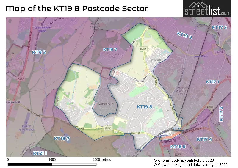
The KT19 8 Postcode shares a border with KT9 2 (CHESSINGTON ), KT17 1 (EWELL , EPSOM ), KT19 9 (WEST EWELL , EPSOM ), KT17 4 (EPSOM , EPSOM DOWNS ), KT18 5 (EPSOM DOWNS , EPSOM ), KT18 7 (EPSOM ) and KT19 7 (EPSOM ).
The sector is within the post town of EPSOM.
KT19 8 is a postcode sector within the KT19 postcode district which is within the KT Kingston upon Thames postcode area.
The Royal Mail delivery office for the KT19 8 postal sector is the Epsom Delivery Office.
The area of the KT19 8 postcode sector is 1.61 square miles which is 4.17 square kilometres or 1,029.44 square acres.

Map of the KT19 8 Postcode Sector
Explore the KT19 8 postcode sector by using our free interactive map.
| K | T | 1 | 9 | - | 8 | X | X |
| K | T | 1 | 9 | Space | 8 | Letter | Letter |
Official List of Streets
EPSOM (98 Streets)
Unofficial Streets or Alternative Spellings
EPSOM
ADELPHI ROAD ASHLEY ROAD CHURCH STREET DANETREE ROAD EAST STREET HAVEN DRIVE LONGMEAD ROAD MCKENZIE WAY MILES ROAD PARKLAWN AVENUE SOUTH STREET STAMFORD GREEN ROAD THE PARADE UPPER HIGH STREET WEST STREET WHEELERS LANE BRIDLEWAY 29 BRIDLEWAY 54 CHERTSEY LANE DEVON CLOSE DRUMMOND GARDENS HORTON GARDENS OAKS SQUARE PATH TO 1 TO 6 CHESTNUT HOUSE, ACER CLOSE STATION WAY SUBWAY TO PLATFORMS SUMMER HORSERIDE VANCOUVER CLOSE WOODSTOCK COURTEwell
CHESSINGTON ROADWeather Forecast for KT19 8
Press Button to Show Forecast for Epsom
| Time Period | Icon | Description | Temperature | Rain Probability | Wind |
|---|---|---|---|---|---|
| 18:00 to 21:00 | Light rain shower (day) | 10.0°C (feels like 8.0°C) | 31.00% | SW 9 mph | |
| 21:00 to 00:00 | Partly cloudy (night) | 8.0°C (feels like 6.0°C) | 5.00% | SSW 7 mph |
Press Button to Show Forecast for Epsom
| Time Period | Icon | Description | Temperature | Rain Probability | Wind |
|---|---|---|---|---|---|
| 00:00 to 03:00 | Clear night | 7.0°C (feels like 4.0°C) | 0.00% | SSW 7 mph | |
| 03:00 to 06:00 | Clear night | 7.0°C (feels like 4.0°C) | 0.00% | SSW 9 mph | |
| 06:00 to 09:00 | Sunny day | 8.0°C (feels like 5.0°C) | 0.00% | S 9 mph | |
| 09:00 to 12:00 | Cloudy | 12.0°C (feels like 10.0°C) | 3.00% | SSW 13 mph | |
| 12:00 to 15:00 | Partly cloudy (day) | 14.0°C (feels like 11.0°C) | 2.00% | SSW 16 mph | |
| 15:00 to 18:00 | Sunny day | 15.0°C (feels like 11.0°C) | 0.00% | SSW 16 mph | |
| 18:00 to 21:00 | Sunny day | 13.0°C (feels like 11.0°C) | 0.00% | S 9 mph | |
| 21:00 to 00:00 | Clear night | 10.0°C (feels like 8.0°C) | 0.00% | SSE 9 mph |
Press Button to Show Forecast for Epsom
| Time Period | Icon | Description | Temperature | Rain Probability | Wind |
|---|---|---|---|---|---|
| 00:00 to 03:00 | Clear night | 9.0°C (feels like 7.0°C) | 0.00% | SE 9 mph | |
| 03:00 to 06:00 | Clear night | 8.0°C (feels like 6.0°C) | 0.00% | SSE 7 mph | |
| 06:00 to 09:00 | Sunny day | 9.0°C (feels like 8.0°C) | 1.00% | SE 7 mph | |
| 09:00 to 12:00 | Sunny day | 14.0°C (feels like 12.0°C) | 2.00% | SSE 11 mph | |
| 12:00 to 15:00 | Cloudy | 16.0°C (feels like 13.0°C) | 8.00% | SSE 13 mph | |
| 15:00 to 18:00 | Cloudy | 16.0°C (feels like 13.0°C) | 11.00% | SSE 11 mph | |
| 18:00 to 21:00 | Cloudy | 15.0°C (feels like 13.0°C) | 12.00% | SSE 9 mph | |
| 21:00 to 00:00 | Cloudy | 12.0°C (feels like 11.0°C) | 12.00% | SE 7 mph |
Press Button to Show Forecast for Epsom
| Time Period | Icon | Description | Temperature | Rain Probability | Wind |
|---|---|---|---|---|---|
| 00:00 to 03:00 | Cloudy | 11.0°C (feels like 10.0°C) | 12.00% | SSE 4 mph | |
| 03:00 to 06:00 | Cloudy | 10.0°C (feels like 9.0°C) | 10.00% | S 4 mph | |
| 06:00 to 09:00 | Mist | 10.0°C (feels like 10.0°C) | 19.00% | E 2 mph | |
| 09:00 to 12:00 | Cloudy | 13.0°C (feels like 12.0°C) | 11.00% | NNE 4 mph | |
| 12:00 to 15:00 | Cloudy | 15.0°C (feels like 14.0°C) | 16.00% | NE 4 mph | |
| 15:00 to 18:00 | Cloudy | 16.0°C (feels like 15.0°C) | 16.00% | NNE 7 mph | |
| 18:00 to 21:00 | Cloudy | 15.0°C (feels like 14.0°C) | 15.00% | NNE 7 mph | |
| 21:00 to 00:00 | Cloudy | 14.0°C (feels like 12.0°C) | 18.00% | NNW 7 mph |
Press Button to Show Forecast for Epsom
| Time Period | Icon | Description | Temperature | Rain Probability | Wind |
|---|---|---|---|---|---|
| 00:00 to 03:00 | Light rain shower (night) | 12.0°C (feels like 10.0°C) | 38.00% | NNW 7 mph | |
| 03:00 to 06:00 | Cloudy | 11.0°C (feels like 10.0°C) | 14.00% | NNW 7 mph | |
| 06:00 to 09:00 | Overcast | 11.0°C (feels like 10.0°C) | 19.00% | NNW 7 mph | |
| 09:00 to 12:00 | Cloudy | 13.0°C (feels like 12.0°C) | 15.00% | NW 7 mph | |
| 12:00 to 15:00 | Cloudy | 16.0°C (feels like 15.0°C) | 12.00% | NW 9 mph | |
| 15:00 to 18:00 | Partly cloudy (day) | 18.0°C (feels like 17.0°C) | 8.00% | NNW 9 mph | |
| 18:00 to 21:00 | Partly cloudy (day) | 17.0°C (feels like 15.0°C) | 8.00% | NNW 9 mph | |
| 21:00 to 00:00 | Partly cloudy (night) | 14.0°C (feels like 13.0°C) | 6.00% | NNW 9 mph |
Schools and Places of Education Within the KT19 8 Postcode Sector
Southfield Park Primary School
Community school
Long Grove Road, Epsom, Surrey, KT19 8TF
Head: Miss Lauren Clogg
Ofsted Rating: Good
Inspection: 2023-01-11 (473 days ago)
Website: Visit Southfield Park Primary School Website
Phone: 01372743104
Number of Pupils: 421
Stamford Green Primary School and Nursery
Community school
Christ Church Mount, Epsom, Surrey, KT19 8LU
Head: Mrs Louise Druce
Ofsted Rating: Outstanding
Inspection: 2015-02-05 (3370 days ago)
Website: Visit Stamford Green Primary School and Nursery Website
Phone: 01372725383
Number of Pupils: 717
House Prices in the KT19 8 Postcode Sector
| Type of Property | 2018 Average | 2018 Sales | 2017 Average | 2017 Sales | 2016 Average | 2016 Sales | 2015 Average | 2015 Sales |
|---|---|---|---|---|---|---|---|---|
| Detached | £814,214 | 21 | £815,915 | 30 | £710,987 | 42 | £696,421 | 26 |
| Semi-Detached | £548,471 | 33 | £550,044 | 43 | £546,262 | 37 | £494,900 | 52 |
| Terraced | £446,533 | 21 | £470,396 | 24 | £465,265 | 37 | £438,640 | 42 |
| Flats | £287,436 | 46 | £288,671 | 76 | £304,175 | 75 | £273,495 | 65 |
Important Postcodes KT19 8 in the Postcode Sector
KT19 8AG is the postcode for Derby Medical Centre, 8 The Derby Square, and Ebbisham Centre, 6-7 The Derby Square
KT19 8LU is the postcode for Stamford Green Primary School, Christ Church Mount
KT19 8PB is the postcode for Surrey and Borders Partnership NHS Trust, West Park Hospital, FARMSIDE, Surrey and Borders Partnership NHS Trust, West Park Hospital, L&D AND TRANSPORT, Surrey and Borders Partnership NHS Trust, West Park Hospital, DAY NURSERY, Surrey and Borders Partnership NHS Trust, West Park Hospital, MEADOWS CENTRAL CORE, Surrey and Borders Partnership NHS Trust, West Park Hospital, and Ramsey House, West Park
KT19 8QJ is the postcode for Surrey and Borders Partnership NHS Trust, St. Ebbas Hospital, WILLOW HOUSE, Surrey and Borders Partnership NHS Trust, St. Ebbas Hospital, HILLCROFT, Surrey and Borders Partnership NHS Trust, St. Ebbas Hospital, GALLWEY UNIT, Surrey and Borders Partnership NHS Trust, St. Ebbas Hospital, and TATTENHAMS, Surrey and Borders Partnership NHS Trust, St. Ebbas Hospital
KT19 8SD is the postcode for Epsom Primary School, Pound Lane
KT19 8TF is the postcode for Southfield Park Primary School, Long Grove Road
| The KT19 8 Sector is within these Local Authorities |
|
|---|---|
| The KT19 8 Sector is within these Counties |
|
| The KT19 8 Sector is within these Water Company Areas |
|