The KT24 postcode district is a postal district located in the KT Kingston upon Thames postcode area with a population of 9,132 residents according to the 2021 England and Wales Census.
The area of the KT24 postcode district is 11.41 square miles which is 29.55 square kilometres or 7,301.68 acres.
Currently, the KT24 district has about 368 postcode units spread across 2 geographic postcode sectors.
Given that each sector allows for 400 unique postcode combinations, the district has a capacity of 800 postcodes. With 368 postcodes already in use, this leaves 432 units available.
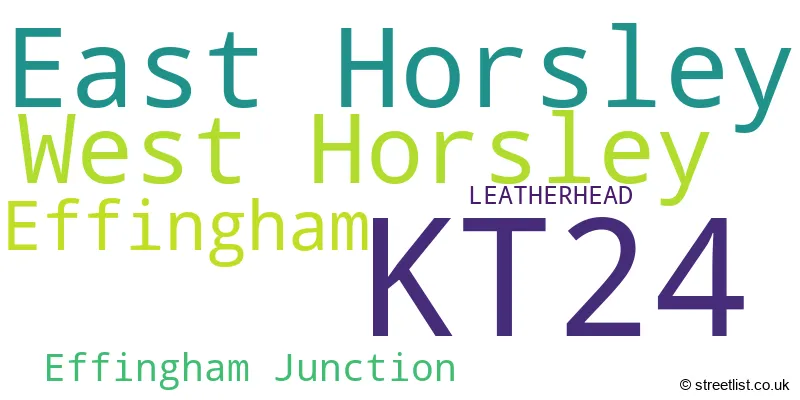
The largest settlement in the KT24 postal code is East Horsley followed by West Horsley, and Effingham.
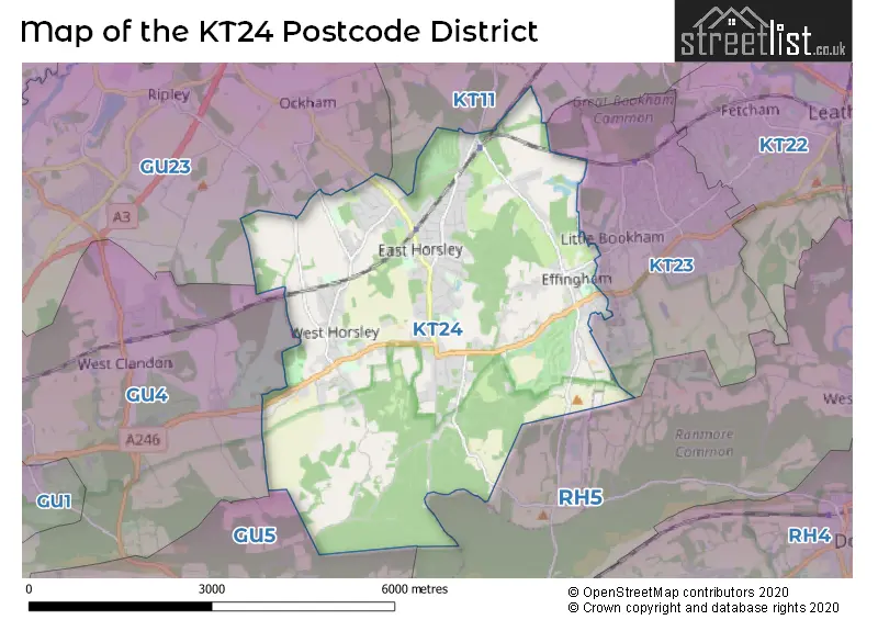
The KT24 Postcode shares a border with GU5 (Bramley, Shamley Green, Albury), KT11 (COBHAM), KT23 (Great Bookham, BOOKHAM, Little Bookham), RH5 (Newdigate, Beare Green, North Holmwood), GU23 (RIPLEY, SEND, OCKHAM) and GU4 (GUILDFORD, Shalford, Chilworth).
In the KT24 postcode district in Surrey, the primary settlement is East Horsley. Other significant settlements include Effingham and West Horsley. The post town for this district is Leatherhead in the county of Surrey, England.
For the district KT24, we have data on 3 postcode sectors. Here's a breakdown: The sector KT24 5, covers Effingham and East Horsley in Surrey. The sector KT24 6, covers West Horsley and East Horsley in Surrey. The sector KT24 9 is non-geographic. It's often designated for PO Boxes, large organisations, or special services.

Map of the KT24 Postcode District
Explore the KT24 postcode district by using our free interactive map.
When it comes to local government, postal geography often disregards political borders. However, for a breakdown in the KT24 District: the district mostly encompasses the Guildford District (B) area with a total of 374 postcodes.
Recent House Sales in KT24
| Date | Price | Address |
|---|---|---|
| 18/09/2023 | £1,043,150 | Holmwood Close, East Horsley, Leatherhead, KT24 6SS |
| 11/09/2023 | £1,875,000 | Chalk Lane, East Horsley, Leatherhead, KT24 6TH |
| 01/09/2023 | £2,075,000 | Lower Farm Road, Effingham, Leatherhead, KT24 5JJ |
| 31/08/2023 | £1,350,000 | Guildford Road, East Horsley, Leatherhead, KT24 5RX |
| 24/08/2023 | £1,225,000 | Forest Gate, East Horsley, Leatherhead, KT24 5AU |
| 22/08/2023 | £550,000 | Ockham Road North, West Horsley, Leatherhead, KT24 6PE |
| 10/08/2023 | £975,000 | Beech Close, Effingham, Leatherhead, KT24 5PQ |
| 04/08/2023 | £1,750,000 | Rowbarns Way, East Horsley, Leatherhead, KT24 5RJ |
| 04/08/2023 | £3,175,000 | Effingham Common Road, Effingham, Leatherhead, KT24 5JF |
| 26/07/2023 | £1,130,000 | Guildford Road, East Horsley, Leatherhead, KT24 5RY |
Weather Forecast for KT24
Press Button to Show Forecast for Hatchlands Park
| Time Period | Icon | Description | Temperature | Rain Probability | Wind |
|---|---|---|---|---|---|
| 09:00 to 12:00 | Overcast | 8.0°C (feels like 5.0°C) | 20.00% | ENE 9 mph | |
| 12:00 to 15:00 | Overcast | 10.0°C (feels like 9.0°C) | 16.00% | NE 9 mph | |
| 15:00 to 18:00 | Cloudy | 11.0°C (feels like 10.0°C) | 12.00% | NE 9 mph | |
| 18:00 to 21:00 | Light rain | 11.0°C (feels like 9.0°C) | 62.00% | NE 7 mph | |
| 21:00 to 00:00 | Heavy rain | 9.0°C (feels like 7.0°C) | 86.00% | NE 9 mph |
Press Button to Show Forecast for Hatchlands Park
| Time Period | Icon | Description | Temperature | Rain Probability | Wind |
|---|---|---|---|---|---|
| 00:00 to 03:00 | Heavy rain | 9.0°C (feels like 6.0°C) | 87.00% | NNE 11 mph | |
| 03:00 to 06:00 | Heavy rain | 8.0°C (feels like 6.0°C) | 91.00% | NNE 9 mph | |
| 06:00 to 09:00 | Heavy rain | 8.0°C (feels like 5.0°C) | 87.00% | N 7 mph | |
| 09:00 to 12:00 | Heavy rain | 8.0°C (feels like 6.0°C) | 81.00% | NW 9 mph | |
| 12:00 to 15:00 | Light rain | 9.0°C (feels like 7.0°C) | 56.00% | WNW 11 mph | |
| 15:00 to 18:00 | Cloudy | 10.0°C (feels like 8.0°C) | 18.00% | W 9 mph | |
| 18:00 to 21:00 | Cloudy | 10.0°C (feels like 8.0°C) | 8.00% | W 7 mph | |
| 21:00 to 00:00 | Partly cloudy (night) | 8.0°C (feels like 6.0°C) | 3.00% | SW 7 mph |
Press Button to Show Forecast for Hatchlands Park
| Time Period | Icon | Description | Temperature | Rain Probability | Wind |
|---|---|---|---|---|---|
| 00:00 to 03:00 | Clear night | 6.0°C (feels like 4.0°C) | 2.00% | SSW 7 mph | |
| 03:00 to 06:00 | Clear night | 5.0°C (feels like 3.0°C) | 1.00% | SSW 4 mph | |
| 06:00 to 09:00 | Sunny day | 6.0°C (feels like 5.0°C) | 1.00% | S 4 mph | |
| 09:00 to 12:00 | Cloudy | 11.0°C (feels like 9.0°C) | 7.00% | S 9 mph | |
| 12:00 to 15:00 | Cloudy | 13.0°C (feels like 11.0°C) | 8.00% | S 11 mph | |
| 15:00 to 18:00 | Partly cloudy (day) | 14.0°C (feels like 11.0°C) | 2.00% | S 11 mph | |
| 18:00 to 21:00 | Sunny day | 12.0°C (feels like 11.0°C) | 1.00% | S 9 mph | |
| 21:00 to 00:00 | Clear night | 8.0°C (feels like 7.0°C) | 2.00% | SSE 7 mph |
Press Button to Show Forecast for Hatchlands Park
| Time Period | Icon | Description | Temperature | Rain Probability | Wind |
|---|---|---|---|---|---|
| 00:00 to 03:00 | Clear night | 8.0°C (feels like 6.0°C) | 3.00% | SE 7 mph | |
| 03:00 to 06:00 | Clear night | 8.0°C (feels like 6.0°C) | 3.00% | SE 7 mph | |
| 06:00 to 09:00 | Sunny day | 9.0°C (feels like 7.0°C) | 5.00% | SE 7 mph | |
| 09:00 to 12:00 | Partly cloudy (day) | 13.0°C (feels like 12.0°C) | 4.00% | SE 9 mph | |
| 12:00 to 15:00 | Cloudy | 16.0°C (feels like 13.0°C) | 12.00% | SE 11 mph | |
| 15:00 to 18:00 | Cloudy | 16.0°C (feels like 14.0°C) | 9.00% | SE 9 mph | |
| 18:00 to 21:00 | Cloudy | 14.0°C (feels like 13.0°C) | 10.00% | SE 7 mph | |
| 21:00 to 00:00 | Cloudy | 12.0°C (feels like 10.0°C) | 9.00% | SE 7 mph |
Where is the KT24 Postcode District?
The KT24 postcode district is located in Leatherhead, a town in Surrey. Leatherhead is surrounded by several nearby towns, including West Horsley to the north, Effingham to the northeast, and Send to the northwest. Additionally, the distance from the KT24 postcode district to the center of London is approximately 21.35 miles.
The district is within the post town of LEATHERHEAD.
The sector has postcodes within the nation of England.
The KT24 Postcode District is in the West Surrey region of Surrey, East and West Sussex within the South East (England).
| Postcode Sector | Delivery Office |
|---|---|
| KT24 5 | East Horsley Delivery Office |
| KT24 6 | East Horsley Delivery Office |
| K | T | 2 | 4 | - | X | X | X |
| K | T | 2 | 4 | Space | Numeric | Letter | Letter |
Current Monthly Rental Prices
| # Bedrooms | Min Price | Max Price | Avg Price |
|---|---|---|---|
| 2 | £1,425 | £1,425 | £1,425 |
| 3 | £3,300 | £4,500 | £3,900 |
| 4 | £2,999 | £7,750 | £5,250 |
| 5 | £3,750 | £5,750 | £5,125 |
Current House Prices
| # Bedrooms | Min Price | Max Price | Avg Price |
|---|---|---|---|
| £490,000 | £2,695,000 | £1,261,667 | |
| 1 | £87,500 | £630,000 | £296,814 |
| 2 | £299,000 | £950,000 | £563,428 |
| 3 | £499,950 | £1,425,000 | £880,622 |
| 4 | £615,000 | £2,700,000 | £1,321,360 |
| 5 | £985,000 | £2,750,000 | £1,765,000 |
| 7 | £3,450,000 | £3,450,000 | £3,450,000 |
Estate Agents who Operate in the KT24 District
| Logo | Name | Brand Name | Address | Contact Number | Total Properties |
|---|---|---|---|---|---|
 | East Horsley | Wills & Smerdon | 6 Station Parade, East Horsley, KT24 6QN | 01483 967680 | 24 |
 | East Horsley | Curchods Estate Agents | 12 Bishopsmead Parade, East Horsley, KT24 6RT | 01483 967758 | 13 |
 | Great Bookham | Henshaws Estate Agents | 32 High Street, Bookham, KT23 4AG | 01372 236838 | 5 |
 | Cobham | Savills | 10 High Street, Cobham, KT11 3DY | 01932 548313 | 5 |
 | Leatherhead | Gascoigne-Pees | London House 29 Church Street Leatherhead Surrey KT22 8DX | 01372 678073 | 4 |
| Type of Property | 2018 Average | 2018 Sales | 2017 Average | 2017 Sales | 2016 Average | 2016 Sales | 2015 Average | 2015 Sales |
|---|---|---|---|---|---|---|---|---|
| Detached | £1,018,241 | 102 | £1,005,601 | 77 | £1,067,907 | 91 | £950,032 | 90 |
| Semi-Detached | £580,782 | 14 | £569,791 | 34 | £572,187 | 30 | £508,820 | 25 |
| Terraced | £499,743 | 6 | £495,000 | 10 | £466,250 | 4 | £549,217 | 9 |
| Flats | £256,000 | 13 | £368,556 | 9 | £333,825 | 10 | £244,050 | 9 |