
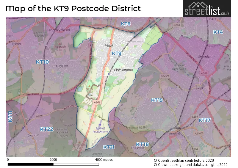
Map of the Postcode District
Explore the postcode district by using our interactive map.
Circles represent recorded crime; the larger the circle, the higher the crime rates.
Your support helps keep this site running!
If you enjoy using this website, consider buying me a coffee to help cover hosting costs.
The postcode district located in the KT Kingston upon Thames postal area , KT9 has a population of 21,792 residents according to the 2021 England and Wales Census.
The area of the district is 4.13 square miles (10.70 square kilometers or 2,644.16 acres).
Where is the KT9 District?
To give you an idea where the district is located we have created the following table showing nearby towns.
Nearest Towns to KT9
| Town | Distance (miles) | Direction |
|---|---|---|
| Epsom | 2.40 | SE |
| Ewell | 2.59 | E |
| Esher | 2.65 | WNW |
| Leatherhead | 4.28 | SSW |
| Banstead | 5.08 | ESE |
| Walton-on-Thames | 5.16 | WNW |
| Sunbury-on-Thames | 6.43 | NW |
| Weybridge | 6.63 | W |
| Addlestone | 8.06 | W |
| Ashford | 8.50 | NW |
| Dorking | 8.59 | S |
| Chertsey | 8.81 | WNW |
| Reigate | 9.33 | SSE |
| Redhill | 9.97 | SE |
| Staines-upon-Thames | 10.31 | WNW |
| Woking | 11.14 | WSW |
| Caterham | 11.19 | ESE |
| Warlingham | 11.37 | ESE |
| Egham | 11.65 | WNW |
| City of Westminster | 12.72 | NE |
The post town for this district is CHESSINGTON.
Postcode Information for District KT9 (Total Geographical Postcodes: 397)
| Location | Post Town | Sector | Number of Postcodes |
|---|---|---|---|
| CHESSINGTON | CHESSINGTON | KT9 2 | 204 |
| CHESSINGTON | CHESSINGTON | KT9 1 | 193 |
Retail and Shopping in KT9
Street
Town
Locality
Number of Shops
Central Postcode
View on Google Maps
HOOK ROAD
CHESSINGTON
38
KT9 1NU
View on Google Maps
NORTH PARADE
CHESSINGTON
16
KT9 1QF
View on Google Maps
LEATHERHEAD ROAD
CHESSINGTON
11
KT9 2HY
View on Google Maps
ELM ROAD
CHESSINGTON
6
KT9 1AB
View on Google Maps
| Street | Town | Locality | Number of Shops | Central Postcode | View on Google Maps |
|---|---|---|---|---|---|
| HOOK ROAD | CHESSINGTON | 38 | KT9 1NU | View on Google Maps | |
| NORTH PARADE | CHESSINGTON | 16 | KT9 1QF | View on Google Maps | |
| LEATHERHEAD ROAD | CHESSINGTON | 11 | KT9 2HY | View on Google Maps | |
| ELM ROAD | CHESSINGTON | 6 | KT9 1AB | View on Google Maps |
The primary settlement in the KT9 postcode district is Chessington, located in the county of Greater London. Additionally, there is another settlement also named Chessington within the same postcode district, located in the county of Surrey.
When it comes to local government, postal geography often disregards political borders. However, this district intersects the following councils: the district mostly encompasses the Kingston upon Thames London Boro (395 postal codes), and finally, the Elmbridge District (B) area (4 postal codes).
The KT9 postal code covers the settlement of CHESSINGTON.
The KT9 Postcode shares a border with KT10 (ESHER, CLAYGATE), KT19 (EPSOM, WEST EWELL, EWELL) and KT6 (SURBITON, TOLWORTH, LONG DITTON).


Schools in the Sector
St Paul's CofE Primary School
Phase: Primary
Address: Orchard Road , Chessington
Postcode: KT9 1AJ
Headteacher: Mrs Emily Evans (Headteacher)
Ofsted Rating: Good
Castle Hill Primary School
Phase: Primary
Address: Buckland Road , Chessington
Postcode: KT9 1JE
Headteacher: Mrs Dalene Johnson (Headteacher)
Ofsted Rating: Good
St Mary's CofE (Aided) Primary School
Phase: Primary
Address: Church Lane , Chessington
Postcode: KT9 2DH
Headteacher: Mrs Emmeline Lawlor (Headteacher)
Ofsted Rating: Good
St Philip's School
Phase: Not applicable
Address: Harrow Close , Leatherhead Road , Chessington
Postcode: KT9 2HR
Headteacher: Mrs J Bowen (Headteacher)
Ofsted Rating: Good
St Philip's School
Phase: Not applicable
Address: Harrow Close , Leatherhead Road , Chessington
Postcode: KT9 2HR
Headteacher: Mr Ben Walsh (Headteacher)
Ofsted Rating: Good
Ellingham Primary School
Phase: Primary
Address: Ellingham Road , Chessington
Postcode: KT9 2JA
Headteacher: Mrs Lisa Keogh (Headteacher)
Ofsted Rating: Good
Chessington School
Phase: Secondary
Address: Garrison Lane , Chessington
Postcode: KT9 2JS
Headteacher: Mr Ashraf Ali (Headteacher)
Ofsted Rating: Good
Lovelace Primary School
Phase: Primary
Address: Mansfield Road , Hook , Chessington
Postcode: KT9 2RN
Headteacher: Mr Matt Sedgwick (Headteacher)
Ofsted Rating: Good
Stations in the Sector
Chessington North
CRS Code: CSN
Operator: SW
Line: Chessington Branch Line
Company: South Western Railway
Chessington South
CRS Code: CSS
Operator: SW
Line: Chessington Branch Line
Company: South Western Railway
Accessable Motorway Junctions
M25 J9
Average Driving Time from within the district: 8.49
Average Driving Distance: 4.80
Number of Postcodes that can access the Motorway Junction: 399
M25 J10
Average Driving Time from within the district: 12.35
Average Driving Distance: 9.50
Number of Postcodes that can access the Motorway Junction: 399
M25 J8
Average Driving Time from within the district: 14.24
Average Driving Distance: 10.82
Number of Postcodes that can access the Motorway Junction: 234
M3 J1
Average Driving Time from within the district: 16.99
Average Driving Distance: 8.94
Number of Postcodes that can access the Motorway Junction: 399
M25 J11
Average Driving Time from within the district: 17.07
Average Driving Distance: 13.60
Number of Postcodes that can access the Motorway Junction: 74
M4 J2
Average Driving Time from within the district: 24.65
Average Driving Distance: 14.08
Number of Postcodes that can access the Motorway Junction: 143
Weather Forecast for Chessington World Of Adventures
| Time Period | Icon | Description | Temperature | Rain Probability | Wind |
|---|---|---|---|---|---|
| 12:00 to 15:00 | Cloudy | 14.0°C (feels like 12.0°C) | 38.00% | SW 9 mph | |
| 15:00 to 18:00 | Partly cloudy (day) | 15.0°C (feels like 13.0°C) | 5.00% | SW 9 mph | |
| 18:00 to 21:00 | Clear night | 12.0°C (feels like 11.0°C) | 1.00% | SW 4 mph | |
| 21:00 to 00:00 | Clear night | 10.0°C (feels like 10.0°C) | 3.00% | SW 4 mph |
| Time Period | Icon | Description | Temperature | Rain Probability | Wind |
|---|---|---|---|---|---|
| 00:00 to 03:00 | Clear night | 10.0°C (feels like 9.0°C) | 3.00% | SSW 4 mph | |
| 03:00 to 06:00 | Fog | 9.0°C (feels like 8.0°C) | 14.00% | S 4 mph | |
| 06:00 to 09:00 | Fog | 9.0°C (feels like 8.0°C) | 14.00% | S 4 mph | |
| 09:00 to 12:00 | Fog | 12.0°C (feels like 11.0°C) | 12.00% | S 4 mph | |
| 12:00 to 15:00 | Partly cloudy (day) | 15.0°C (feels like 14.0°C) | 1.00% | S 9 mph | |
| 15:00 to 18:00 | Partly cloudy (day) | 15.0°C (feels like 14.0°C) | 2.00% | S 7 mph | |
| 18:00 to 21:00 | Clear night | 11.0°C (feels like 10.0°C) | 0.00% | SSE 7 mph | |
| 21:00 to 00:00 | Clear night | 10.0°C (feels like 9.0°C) | 0.00% | SE 7 mph |
| Time Period | Icon | Description | Temperature | Rain Probability | Wind |
|---|---|---|---|---|---|
| 00:00 to 03:00 | Clear night | 10.0°C (feels like 8.0°C) | 0.00% | SE 9 mph | |
| 03:00 to 06:00 | Clear night | 10.0°C (feels like 8.0°C) | 1.00% | SE 9 mph | |
| 06:00 to 09:00 | Clear night | 10.0°C (feels like 8.0°C) | 1.00% | SE 9 mph | |
| 09:00 to 12:00 | Partly cloudy (day) | 12.0°C (feels like 10.0°C) | 1.00% | SSE 11 mph | |
| 12:00 to 15:00 | Cloudy | 15.0°C (feels like 13.0°C) | 5.00% | S 13 mph | |
| 15:00 to 18:00 | Partly cloudy (day) | 15.0°C (feels like 13.0°C) | 3.00% | S 13 mph | |
| 18:00 to 21:00 | Partly cloudy (night) | 14.0°C (feels like 12.0°C) | 5.00% | SSE 11 mph | |
| 21:00 to 00:00 | Partly cloudy (night) | 15.0°C (feels like 13.0°C) | 9.00% | S 13 mph |
| Time Period | Icon | Description | Temperature | Rain Probability | Wind |
|---|---|---|---|---|---|
| 00:00 to 03:00 | Partly cloudy (night) | 14.0°C (feels like 12.0°C) | 20.00% | S 13 mph | |
| 03:00 to 06:00 | Cloudy | 13.0°C (feels like 11.0°C) | 17.00% | SSW 11 mph | |
| 06:00 to 09:00 | Light rain shower (night) | 11.0°C (feels like 10.0°C) | 32.00% | SSW 9 mph | |
| 09:00 to 12:00 | Partly cloudy (day) | 12.0°C (feels like 10.0°C) | 4.00% | SSW 11 mph | |
| 12:00 to 15:00 | Light rain shower (day) | 13.0°C (feels like 11.0°C) | 30.00% | SW 13 mph | |
| 15:00 to 18:00 | Partly cloudy (day) | 13.0°C (feels like 10.0°C) | 11.00% | SW 13 mph | |
| 18:00 to 21:00 | Clear night | 10.0°C (feels like 8.0°C) | 3.00% | SW 11 mph | |
| 21:00 to 00:00 | Clear night | 9.0°C (feels like 7.0°C) | 1.00% | SW 9 mph |
| Time Period | Icon | Description | Temperature | Rain Probability | Wind |
|---|---|---|---|---|---|
| 00:00 to 03:00 | Clear night | 8.0°C (feels like 6.0°C) | 1.00% | SW 9 mph | |
| 03:00 to 06:00 | Clear night | 8.0°C (feels like 6.0°C) | 1.00% | SW 9 mph | |
| 06:00 to 09:00 | Clear night | 8.0°C (feels like 6.0°C) | 2.00% | SW 9 mph | |
| 09:00 to 12:00 | Sunny day | 10.0°C (feels like 8.0°C) | 7.00% | SW 9 mph | |
| 12:00 to 15:00 | Partly cloudy (day) | 12.0°C (feels like 10.0°C) | 9.00% | SW 13 mph | |
| 15:00 to 18:00 | Cloudy | 13.0°C (feels like 10.0°C) | 13.00% | SW 11 mph | |
| 18:00 to 21:00 | Clear night | 11.0°C (feels like 9.0°C) | 9.00% | SW 11 mph | |
| 21:00 to 00:00 | Clear night | 11.0°C (feels like 9.0°C) | 7.00% | SW 9 mph |
| Postal Sector | Delivery Office |
|---|---|
| KT9 1 | Chessington Delivery Office |
| KT9 2 | Chessington Delivery Office |
| K | T | 9 | - | X | X | X |
| K | T | 9 | Space | Numeric | Letter | Letter |
Street List for the KT9 District
Current Monthly Rental Prices
| # Bedrooms | Min Price | Max Price | Avg Price |
|---|---|---|---|
| £995 | £995 | £995 | |
| 2 | £1,600 | £1,600 | £1,600 |
| 3 | £1,850 | £2,230 | £1,996 |
| 4 | £1,750 | £1,750 | £1,750 |
Current House Prices
| # Bedrooms | Min Price | Max Price | Avg Price |
|---|---|---|---|
| £120,000 | £120,000 | £120,000 | |
| 1 | £175,000 | £300,000 | £252,143 |
| 2 | £200,000 | £475,000 | £399,643 |
| 3 | £340,000 | £699,950 | £532,240 |
| 4 | £570,000 | £1,500,000 | £905,000 |
| 5 | £800,000 | £800,000 | £800,000 |
Estate Agents
| Logo | Name | Brand Name | Address | Contact Number |
|---|---|---|---|---|
 | Chessington | Nicholls Residential | 442 Hook Road, Chessington, KT9 1NA | 020 3907 3755 |
 | Chessington | Compass Property Ltd | 36 North Parade Chessington KT9 1QF | 020 3879 5785 |
 | Chessington | Gascoigne-Pees | 9 North Parade, Chessington, Surrey, KT9 1QL | 020 3917 4303 |
 | Ewell | Barnard Marcus | Unit 2, 429 Kingston Road West Ewell Ewell Epsom KT19 0DB | 020 3835 3384 |
 | South West London and Surrey | Laurels | Argent Court, Unit B Hook Rise South Surbiton KT6 7NL | 020 3840 3884 |
Yearly House Price Averages for the District
| Type of Property | 2018 Average | 2018 Sales | 2017 Average | 2017 Sales | 2016 Average | 2016 Sales | 2015 Average | 2015 Sales |
|---|---|---|---|---|---|---|---|---|
| Detached | £482,400 | 15 | £564,990 | 25 | £529,774 | 21 | £507,334 | 34 |
| Semi-Detached | £455,381 | 80 | £449,222 | 105 | £440,010 | 82 | £381,395 | 103 |
| Terraced | £390,306 | 98 | £392,227 | 115 | £383,193 | 122 | £343,976 | 137 |
| Flats | £276,276 | 59 | £290,884 | 51 | £259,284 | 67 | £225,438 | 76 |