The L39 5 postcode sector is within the county of Lancashire.
Did you know? According to the 2021 Census, the L39 5 postcode sector is home to a bustling 4,406 residents!
Given that each sector allows for 400 unique postcode combinations. Letters C, I, K, M, O and V are not allowed in the last two letters of a postcode. With 114 postcodes already in use, this leaves 286 units available.
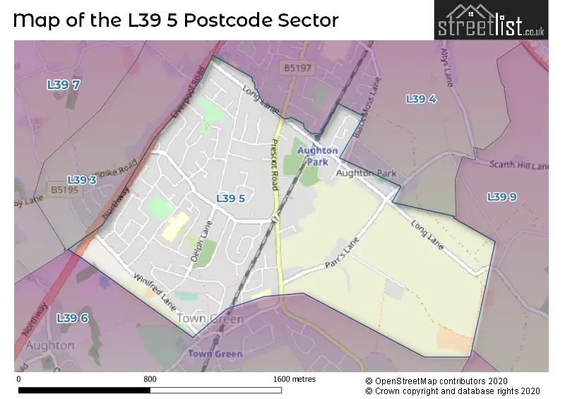
The L39 5 postal code covers the settlement of Aughton.
The L39 5 Postcode shares a border with L39 4 (ORMSKIRK, Aughton), L39 0 (Bickerstaffe), L39 3 (ORMSKIRK, Aughton), L39 6 (Aughton) and L39 9 (Bickerstaffe, Lathom, ORMSKIRK).
The sector is within the post town of ORMSKIRK.
L39 5 is a postcode sector within the L3 postcode district which is within the L Liverpool postcode area.
The Royal Mail delivery office for the L39 5 postal sector is the Liverpool 1-3.
The area of the L39 5 postcode sector is 0.95 square miles which is 2.47 square kilometres or 609.97 square acres.

Map of the L39 5 Postcode Sector
Explore the L39 5 postcode sector by using our free interactive map.
| L | 3 | 9 | - | 5 | X | X |
| L | 3 | 9 | Space | 5 | Letter | Letter |
Official List of Streets
Aughton (68 Streets)
Unofficial Streets or Alternative Spellings
Weather Forecast for L39 5
Press Button to Show Forecast for Ormskirk
| Time Period | Icon | Description | Temperature | Rain Probability | Wind |
|---|---|---|---|---|---|
| 21:00 to 00:00 | Cloudy | 13.0°C (feels like 12.0°C) | 5.00% | WNW 4 mph |
Press Button to Show Forecast for Ormskirk
| Time Period | Icon | Description | Temperature | Rain Probability | Wind |
|---|---|---|---|---|---|
| 00:00 to 03:00 | Cloudy | 12.0°C (feels like 12.0°C) | 5.00% | WSW 2 mph | |
| 03:00 to 06:00 | Cloudy | 12.0°C (feels like 12.0°C) | 5.00% | S 2 mph | |
| 06:00 to 09:00 | Cloudy | 12.0°C (feels like 12.0°C) | 4.00% | SSE 2 mph | |
| 09:00 to 12:00 | Cloudy | 14.0°C (feels like 14.0°C) | 3.00% | W 2 mph | |
| 12:00 to 15:00 | Cloudy | 15.0°C (feels like 14.0°C) | 3.00% | NW 7 mph | |
| 15:00 to 18:00 | Cloudy | 16.0°C (feels like 15.0°C) | 3.00% | NW 7 mph | |
| 18:00 to 21:00 | Cloudy | 15.0°C (feels like 14.0°C) | 3.00% | NNW 7 mph | |
| 21:00 to 00:00 | Cloudy | 13.0°C (feels like 12.0°C) | 4.00% | N 4 mph |
Press Button to Show Forecast for Ormskirk
| Time Period | Icon | Description | Temperature | Rain Probability | Wind |
|---|---|---|---|---|---|
| 00:00 to 03:00 | Cloudy | 12.0°C (feels like 12.0°C) | 5.00% | ENE 2 mph | |
| 03:00 to 06:00 | Cloudy | 11.0°C (feels like 11.0°C) | 5.00% | E 2 mph | |
| 06:00 to 09:00 | Cloudy | 12.0°C (feels like 11.0°C) | 4.00% | ESE 4 mph | |
| 09:00 to 12:00 | Cloudy | 15.0°C (feels like 15.0°C) | 4.00% | SE 4 mph | |
| 12:00 to 15:00 | Cloudy | 19.0°C (feels like 18.0°C) | 4.00% | S 4 mph | |
| 15:00 to 18:00 | Cloudy | 19.0°C (feels like 19.0°C) | 4.00% | E 4 mph | |
| 18:00 to 21:00 | Partly cloudy (day) | 18.0°C (feels like 18.0°C) | 0.00% | SW 4 mph | |
| 21:00 to 00:00 | Clear night | 15.0°C (feels like 14.0°C) | 0.00% | SW 4 mph |
Press Button to Show Forecast for Ormskirk
| Time Period | Icon | Description | Temperature | Rain Probability | Wind |
|---|---|---|---|---|---|
| 00:00 to 03:00 | Clear night | 13.0°C (feels like 13.0°C) | 0.00% | SSE 2 mph | |
| 03:00 to 06:00 | Clear night | 12.0°C (feels like 11.0°C) | 0.00% | ESE 4 mph | |
| 06:00 to 09:00 | Sunny day | 13.0°C (feels like 12.0°C) | 1.00% | ESE 7 mph | |
| 09:00 to 12:00 | Sunny day | 17.0°C (feels like 16.0°C) | 1.00% | SE 7 mph | |
| 12:00 to 15:00 | Partly cloudy (day) | 19.0°C (feels like 18.0°C) | 1.00% | SSE 9 mph | |
| 15:00 to 18:00 | Partly cloudy (day) | 20.0°C (feels like 18.0°C) | 1.00% | S 9 mph | |
| 18:00 to 21:00 | Partly cloudy (day) | 19.0°C (feels like 18.0°C) | 1.00% | S 9 mph | |
| 21:00 to 00:00 | Clear night | 16.0°C (feels like 15.0°C) | 1.00% | SE 7 mph |
Press Button to Show Forecast for Ormskirk
| Time Period | Icon | Description | Temperature | Rain Probability | Wind |
|---|---|---|---|---|---|
| 00:00 to 03:00 | Clear night | 15.0°C (feels like 14.0°C) | 1.00% | ESE 9 mph | |
| 03:00 to 06:00 | Clear night | 14.0°C (feels like 12.0°C) | 1.00% | SE 9 mph | |
| 06:00 to 09:00 | Partly cloudy (day) | 14.0°C (feels like 12.0°C) | 2.00% | SE 9 mph | |
| 09:00 to 12:00 | Cloudy | 17.0°C (feels like 15.0°C) | 4.00% | SE 9 mph | |
| 12:00 to 15:00 | Partly cloudy (day) | 19.0°C (feels like 17.0°C) | 3.00% | SSE 11 mph | |
| 15:00 to 18:00 | Cloudy | 19.0°C (feels like 17.0°C) | 11.00% | S 11 mph | |
| 18:00 to 21:00 | Cloudy | 17.0°C (feels like 16.0°C) | 14.00% | S 9 mph | |
| 21:00 to 00:00 | Cloudy | 15.0°C (feels like 14.0°C) | 10.00% | SSE 9 mph |
Schools and Places of Education Within the L39 5 Postcode Sector
Aughton Christ Church Church of England Voluntary Controlled Primary School
Voluntary controlled school
Long Lane, Ormskirk, Lancashire, L39 5AS
Head: Mr David Kennedy
Ofsted Rating: Outstanding
Inspection: 2012-06-21 (4339 days ago)
Website: Visit Aughton Christ Church Church of England Voluntary Controlled Primary School Website
Phone: 01695421391
Number of Pupils: 196
Aughton St Michael's Church of England Primary School
Voluntary controlled school
Delph Park Avenue, Ormskirk, Lancashire, L39 5DG
Head: Mr Christopher Clare
Ofsted Rating: Outstanding
Inspection: 2008-12-12 (5626 days ago)
Website: Visit Aughton St Michael's Church of England Primary School Website
Phone: 01695423295
Number of Pupils: 198
House Prices in the L39 5 Postcode Sector
| Type of Property | 2018 Average | 2018 Sales | 2017 Average | 2017 Sales | 2016 Average | 2016 Sales | 2015 Average | 2015 Sales |
|---|---|---|---|---|---|---|---|---|
| Detached | £475,474 | 38 | £459,939 | 44 | £415,403 | 56 | £406,312 | 43 |
| Semi-Detached | £245,771 | 24 | £225,521 | 32 | £211,198 | 25 | £243,189 | 21 |
| Terraced | £193,013 | 8 | £204,042 | 12 | £178,890 | 5 | £169,250 | 2 |
| Flats | £212,817 | 6 | £171,161 | 9 | £200,889 | 9 | £205,788 | 12 |
Important Postcodes L39 5 in the Postcode Sector
L39 5AS is the postcode for Aughton Christ Church C of E Primary School, Long Lane, and Aughton Christ Church C of E Primary School, Long Lane, Aughton
L39 5DG is the postcode for Aughton St Michaels C Of E Primary School, Delph Park Avenue, and Aughton St. Michaels C of E School, Delph Park Avenue
| The L39 5 Sector is within these Local Authorities |
|
|---|---|
| The L39 5 Sector is within these Counties |
|
| The L39 5 Sector is within these Water Company Areas |
|