The L36 9 postcode sector is within the county of Merseyside.
Did you know? According to the 2021 Census, the L36 9 postcode sector is home to a bustling 2,251 residents!
Given that each sector allows for 400 unique postcode combinations. Letters C, I, K, M, O and V are not allowed in the last two letters of a postcode. With 94 postcodes already in use, this leaves 306 units available.
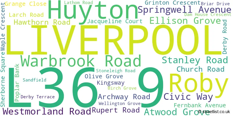
The largest settlement in the L36 9 postal code is LIVERPOOL followed by Huyton, and Roby.
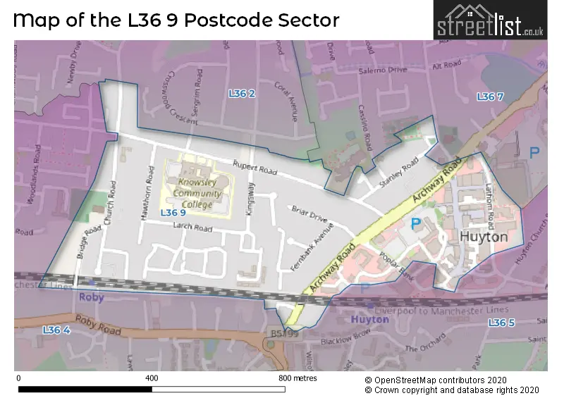
The L36 9 Postcode shares a border with L36 2 (LIVERPOOL, Huyton), L36 4 (LIVERPOOL, Huyton), L36 5 (LIVERPOOL, Huyton) and L36 7 (LIVERPOOL, Huyton).
The sector is within the post town of LIVERPOOL.
L36 9 is a postcode sector within the L36 postcode district which is within the L Liverpool postcode area.
The Royal Mail delivery office for the L36 9 postal sector is the Huyton Delivery Office.
The area of the L36 9 postcode sector is 0.22 square miles which is 0.57 square kilometres or 141.21 square acres.

Map of the L36 9 Postcode Sector
Explore the L36 9 postcode sector by using our free interactive map.
| L | 3 | 6 | - | 9 | X | X |
| L | 3 | 6 | Space | 9 | Letter | Letter |
Official List of Streets
LIVERPOOL (18 Streets)
Huyton (8 Streets)
Unofficial Streets or Alternative Spellings
Weather Forecast for L36 9
Press Button to Show Forecast for Roby
| Time Period | Icon | Description | Temperature | Rain Probability | Wind |
|---|---|---|---|---|---|
| 15:00 to 18:00 | Cloudy | 10.0°C (feels like 9.0°C) | 16.00% | ENE 4 mph | |
| 18:00 to 21:00 | Cloudy | 9.0°C (feels like 7.0°C) | 11.00% | NNE 7 mph | |
| 21:00 to 00:00 | Cloudy | 7.0°C (feels like 5.0°C) | 8.00% | E 9 mph |
Press Button to Show Forecast for Roby
| Time Period | Icon | Description | Temperature | Rain Probability | Wind |
|---|---|---|---|---|---|
| 00:00 to 03:00 | Cloudy | 6.0°C (feels like 4.0°C) | 6.00% | E 7 mph | |
| 03:00 to 06:00 | Partly cloudy (night) | 5.0°C (feels like 3.0°C) | 3.00% | ENE 7 mph | |
| 06:00 to 09:00 | Partly cloudy (day) | 5.0°C (feels like 2.0°C) | 2.00% | ENE 7 mph | |
| 09:00 to 12:00 | Cloudy | 8.0°C (feels like 6.0°C) | 6.00% | E 9 mph | |
| 12:00 to 15:00 | Overcast | 10.0°C (feels like 8.0°C) | 47.00% | ENE 9 mph | |
| 15:00 to 18:00 | Overcast | 10.0°C (feels like 8.0°C) | 46.00% | ENE 9 mph | |
| 18:00 to 21:00 | Overcast | 9.0°C (feels like 7.0°C) | 49.00% | ENE 9 mph | |
| 21:00 to 00:00 | Cloudy | 8.0°C (feels like 6.0°C) | 5.00% | NE 7 mph |
Press Button to Show Forecast for Roby
| Time Period | Icon | Description | Temperature | Rain Probability | Wind |
|---|---|---|---|---|---|
| 00:00 to 03:00 | Cloudy | 6.0°C (feels like 4.0°C) | 4.00% | NNE 7 mph | |
| 03:00 to 06:00 | Cloudy | 5.0°C (feels like 3.0°C) | 4.00% | N 7 mph | |
| 06:00 to 09:00 | Cloudy | 6.0°C (feels like 3.0°C) | 8.00% | N 9 mph | |
| 09:00 to 12:00 | Cloudy | 8.0°C (feels like 5.0°C) | 11.00% | NNW 9 mph | |
| 12:00 to 15:00 | Cloudy | 10.0°C (feels like 7.0°C) | 12.00% | NW 11 mph | |
| 15:00 to 18:00 | Partly cloudy (day) | 11.0°C (feels like 8.0°C) | 8.00% | WNW 11 mph | |
| 18:00 to 21:00 | Sunny day | 10.0°C (feels like 8.0°C) | 3.00% | W 11 mph | |
| 21:00 to 00:00 | Clear night | 8.0°C (feels like 6.0°C) | 2.00% | SW 9 mph |
Press Button to Show Forecast for Roby
| Time Period | Icon | Description | Temperature | Rain Probability | Wind |
|---|---|---|---|---|---|
| 00:00 to 03:00 | Clear night | 7.0°C (feels like 5.0°C) | 1.00% | SSW 9 mph | |
| 03:00 to 06:00 | Cloudy | 6.0°C (feels like 3.0°C) | 5.00% | SSE 9 mph | |
| 06:00 to 09:00 | Cloudy | 6.0°C (feels like 3.0°C) | 7.00% | SSE 11 mph | |
| 09:00 to 12:00 | Partly cloudy (day) | 10.0°C (feels like 8.0°C) | 2.00% | SSE 13 mph | |
| 12:00 to 15:00 | Overcast | 13.0°C (feels like 10.0°C) | 10.00% | S 16 mph | |
| 15:00 to 18:00 | Cloudy | 13.0°C (feels like 10.0°C) | 9.00% | S 16 mph | |
| 18:00 to 21:00 | Cloudy | 13.0°C (feels like 10.0°C) | 8.00% | SSE 13 mph | |
| 21:00 to 00:00 | Clear night | 11.0°C (feels like 8.0°C) | 3.00% | SSE 13 mph |
Press Button to Show Forecast for Roby
| Time Period | Icon | Description | Temperature | Rain Probability | Wind |
|---|---|---|---|---|---|
| 00:00 to 03:00 | Partly cloudy (night) | 9.0°C (feels like 7.0°C) | 4.00% | SE 13 mph | |
| 03:00 to 06:00 | Partly cloudy (night) | 8.0°C (feels like 6.0°C) | 4.00% | SE 11 mph | |
| 06:00 to 09:00 | Partly cloudy (day) | 9.0°C (feels like 6.0°C) | 4.00% | SE 13 mph | |
| 09:00 to 12:00 | Partly cloudy (day) | 12.0°C (feels like 9.0°C) | 4.00% | SE 13 mph | |
| 12:00 to 15:00 | Partly cloudy (day) | 15.0°C (feels like 12.0°C) | 5.00% | SE 16 mph | |
| 15:00 to 18:00 | Cloudy | 16.0°C (feels like 13.0°C) | 14.00% | SE 13 mph | |
| 18:00 to 21:00 | Partly cloudy (day) | 15.0°C (feels like 13.0°C) | 6.00% | SE 11 mph | |
| 21:00 to 00:00 | Cloudy | 13.0°C (feels like 11.0°C) | 8.00% | ESE 9 mph |
Schools and Places of Education Within the L36 9 Postcode Sector
Huyton With Roby Church of England Primary School
Academy converter
Rupert Road, Liverpool, Merseyside, L36 9TF
Head: Mrs Jillian Stratford
Ofsted Rating: Good
Inspection: 2022-04-27 (730 days ago)
Website: Visit Huyton With Roby Church of England Primary School Website
Phone: 01514778460
Number of Pupils: 425
House Prices in the L36 9 Postcode Sector
| Type of Property | 2018 Average | 2018 Sales | 2017 Average | 2017 Sales | 2016 Average | 2016 Sales | 2015 Average | 2015 Sales |
|---|---|---|---|---|---|---|---|---|
| Detached | £258,497 | 7 | £228,292 | 22 | £233,647 | 20 | £209,696 | 10 |
| Semi-Detached | £185,312 | 30 | £184,379 | 38 | £174,665 | 59 | £167,833 | 30 |
| Terraced | £133,000 | 2 | £168,189 | 5 | £145,000 | 1 | £118,000 | 3 |
| Flats | £80,357 | 7 | £87,999 | 5 | £62,429 | 7 | £72,040 | 6 |
Important Postcodes L36 9 in the Postcode Sector
L36 9FB is the postcode for Knowsley Metropolitan Borough Council, Huyton
L36 9GA is the postcode for Knowlsey Integrated Delivery Services, 4 Ellison Grove, and Sexual Health Services, The Arch, 2 Ellison Grove
L36 9GD is the postcode for Knowsley Metropolitan Borough Council, Huyton Library, Civic Way, and Knowsley Metropolitan Borough Council, The Venue
L36 9TD is the postcode for J BLOCK, Knowsley Associates Ltd, Knowsley Community College, Rupert Road, MAIN SITE, Knowsley Associates Ltd, Knowsley Community College, Rupert Road, and Knowsley Associates Ltd, Knowsley Community College, Rupert Road
L36 9TF is the postcode for Huyton with Roby C of E Aided Primary School, Rupert Road
L36 9US is the postcode for National Probation Service, Poplar House, Poplar Bank
L36 9UX is the postcode for Knowsley Metropolitan Borough Council, Municipal Buildings, Archway Road
L36 9XS is the postcode for Jobcentre Plus, Edendale House, Lathom Road
L36 9XU is the postcode for Merseyside Police, Huyton Police Station, Lathom Road
L36 9XY is the postcode for Knowsley Magistrates Court, Lathom Road
| The L36 9 Sector is within these Local Authorities |
|
|---|---|
| The L36 9 Sector is within these Counties |
|
| The L36 9 Sector is within these Water Company Areas |
|