The LA22 9 postcode sector is within the county of Cumbria.
Did you know? According to the 2021 Census, the LA22 9 postcode sector is home to a bustling 2,882 residents!
Given that each sector allows for 400 unique postcode combinations. Letters C, I, K, M, O and V are not allowed in the last two letters of a postcode. With 215 postcodes already in use, this leaves 185 units available.
The largest settlement in the LA22 9 postal code is AMBLESIDE followed by Grasmere, and Chapel Stile.
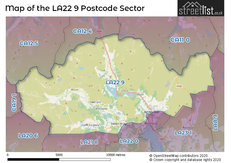
The LA22 9 Postcode shares a border with CA11 0 (Stainton, Greystoke, Glenridding), CA12 4 (KESWICK, Threlkeld, Bassenthwaite), CA12 5 (KESWICK, Braithwaite, Portinscale), CA19 1 (Drigg, Eskdale, HOLMROOK), LA20 6 (BROUGHTON-IN-FURNESS, Ulpha, Seathwaite), LA21 8 (CONISTON, Torver, Haws Bank), LA22 0 (AMBLESIDE, Hawkshead, Far Sawrey), LA23 1 (WINDERMERE, Troutbeck Bridge, Troutbeck) and LA8 9 (Staveley, Selside, Burneside).
The sector is within the post town of AMBLESIDE.
LA22 9 is a postcode sector within the LA2 postcode district which is within the LA Lancaster postcode area.
The Royal Mail delivery office for the LA22 9 postal sector is the Lancaster Delivery Office.
The area of the LA22 9 postcode sector is 46.11 square miles which is 119.43 square kilometres or 29,511.56 square acres.
Waterways within the LA22 9 postcode sector include the River Brathay, Great Langdale Beck, River Rothay, Stock Ghyll, River Runce ?, Far Easedale Gill, Rydal Beck, Scandale Beck.

Map of the LA22 9 Postcode Sector
Explore the LA22 9 postcode sector by using our free interactive map.
| L | A | 2 | 2 | - | 9 | X | X |
| L | A | 2 | 2 | Space | 9 | Letter | Letter |
Official List of Streets
Chapel Stile (7 Streets)
AMBLESIDE (49 Streets)
Grasmere (19 Streets)
Elterwater (5 Streets)
Little Langdale (1 Streets)
Unofficial Streets or Alternative Spellings
AMBLESIDE
CHEAPSIDE KING STREET THE FALLSWaterhead
LAKE ROADWeather Forecast for LA22 9
Press Button to Show Forecast for Grasmere Butharlyp Howe Youth Hostel
| Time Period | Icon | Description | Temperature | Rain Probability | Wind |
|---|---|---|---|---|---|
| 03:00 to 06:00 | Heavy rain | 8.0°C (feels like 6.0°C) | 83.00% | S 7 mph | |
| 06:00 to 09:00 | Heavy rain | 8.0°C (feels like 6.0°C) | 84.00% | S 9 mph | |
| 09:00 to 12:00 | Heavy rain | 9.0°C (feels like 6.0°C) | 86.00% | S 13 mph | |
| 12:00 to 15:00 | Heavy rain | 10.0°C (feels like 7.0°C) | 94.00% | S 13 mph | |
| 15:00 to 18:00 | Heavy rain | 10.0°C (feels like 7.0°C) | 96.00% | S 16 mph | |
| 18:00 to 21:00 | Heavy rain | 10.0°C (feels like 7.0°C) | 93.00% | S 13 mph | |
| 21:00 to 00:00 | Heavy rain | 10.0°C (feels like 7.0°C) | 87.00% | S 11 mph |
Press Button to Show Forecast for Grasmere Butharlyp Howe Youth Hostel
| Time Period | Icon | Description | Temperature | Rain Probability | Wind |
|---|---|---|---|---|---|
| 00:00 to 03:00 | Heavy rain | 9.0°C (feels like 7.0°C) | 81.00% | SSE 11 mph | |
| 03:00 to 06:00 | Light rain | 9.0°C (feels like 7.0°C) | 60.00% | SSE 11 mph | |
| 06:00 to 09:00 | Light rain | 9.0°C (feels like 6.0°C) | 57.00% | SE 13 mph | |
| 09:00 to 12:00 | Light rain | 11.0°C (feels like 8.0°C) | 50.00% | SE 16 mph | |
| 12:00 to 15:00 | Cloudy | 15.0°C (feels like 11.0°C) | 10.00% | SSE 16 mph | |
| 15:00 to 18:00 | Cloudy | 15.0°C (feels like 12.0°C) | 13.00% | SSE 13 mph | |
| 18:00 to 21:00 | Cloudy | 13.0°C (feels like 12.0°C) | 15.00% | SSE 9 mph | |
| 21:00 to 00:00 | Overcast | 10.0°C (feels like 9.0°C) | 19.00% | SSE 7 mph |
Press Button to Show Forecast for Grasmere Butharlyp Howe Youth Hostel
| Time Period | Icon | Description | Temperature | Rain Probability | Wind |
|---|---|---|---|---|---|
| 00:00 to 03:00 | Cloudy | 10.0°C (feels like 8.0°C) | 45.00% | SE 7 mph | |
| 03:00 to 06:00 | Cloudy | 8.0°C (feels like 7.0°C) | 13.00% | ESE 4 mph | |
| 06:00 to 09:00 | Cloudy | 9.0°C (feels like 9.0°C) | 7.00% | ESE 4 mph | |
| 09:00 to 12:00 | Partly cloudy (day) | 12.0°C (feels like 12.0°C) | 3.00% | ESE 4 mph | |
| 12:00 to 15:00 | Cloudy | 15.0°C (feels like 14.0°C) | 9.00% | SSE 7 mph | |
| 15:00 to 18:00 | Cloudy | 15.0°C (feels like 14.0°C) | 10.00% | SW 4 mph | |
| 18:00 to 21:00 | Cloudy | 14.0°C (feels like 13.0°C) | 9.00% | WNW 4 mph | |
| 21:00 to 00:00 | Cloudy | 11.0°C (feels like 10.0°C) | 5.00% | W 4 mph |
Press Button to Show Forecast for Grasmere Butharlyp Howe Youth Hostel
| Time Period | Icon | Description | Temperature | Rain Probability | Wind |
|---|---|---|---|---|---|
| 00:00 to 03:00 | Cloudy | 10.0°C (feels like 9.0°C) | 7.00% | NNW 4 mph | |
| 03:00 to 06:00 | Cloudy | 10.0°C (feels like 8.0°C) | 8.00% | N 7 mph | |
| 06:00 to 09:00 | Cloudy | 11.0°C (feels like 10.0°C) | 5.00% | N 7 mph | |
| 09:00 to 12:00 | Partly cloudy (day) | 14.0°C (feels like 13.0°C) | 1.00% | N 9 mph | |
| 12:00 to 15:00 | Sunny day | 17.0°C (feels like 15.0°C) | 2.00% | NNE 11 mph | |
| 15:00 to 18:00 | Partly cloudy (day) | 18.0°C (feels like 15.0°C) | 3.00% | NNE 11 mph | |
| 18:00 to 21:00 | Sunny day | 16.0°C (feels like 14.0°C) | 2.00% | NNE 11 mph | |
| 21:00 to 00:00 | Clear night | 11.0°C (feels like 10.0°C) | 1.00% | NNE 9 mph |
Schools and Places of Education Within the LA22 9 Postcode Sector
Ambleside CofE Primary School
Academy sponsor led
Vicarage Road, Ambleside, Cumbria, LA22 9DH
Head: Mrs Alison Broom
Ofsted Rating: Good
Inspection: 2018-09-13 (2055 days ago)
Website: Visit Ambleside CofE Primary School Website
Phone: 01539432181
Number of Pupils: 80
Grasmere CofE Primary School
Voluntary aided school
Stock Lane, Ambleside, Cumbria, LA22 9SJ
Head: Mrs Johanna Goode
Ofsted Rating: Good
Inspection: 2020-03-04 (1517 days ago)
Website: Visit Grasmere CofE Primary School Website
Phone: 01539435313
Number of Pupils: 83
Langdale CofE School
Voluntary aided school
Chapel Stile, Ambleside, Cumbria, LA22 9JE
Head: Mrs Rachel Underwood
Ofsted Rating: Good
Inspection: 2021-11-17 (894 days ago)
Website: Visit Langdale CofE School Website
Phone: 01539437204
Number of Pupils: 25
House Prices in the LA22 9 Postcode Sector
| Type of Property | 2018 Average | 2018 Sales | 2017 Average | 2017 Sales | 2016 Average | 2016 Sales | 2015 Average | 2015 Sales |
|---|---|---|---|---|---|---|---|---|
| Detached | £670,273 | 13 | £724,366 | 19 | £657,385 | 13 | £509,565 | 17 |
| Semi-Detached | £506,408 | 6 | £399,681 | 8 | £400,625 | 4 | £507,000 | 6 |
| Terraced | £296,369 | 21 | £340,652 | 24 | £287,874 | 23 | £352,515 | 29 |
| Flats | £245,421 | 14 | £257,688 | 16 | £219,479 | 24 | £220,423 | 13 |
Important Postcodes LA22 9 in the Postcode Sector
LA22 9BA is the postcode for FAIRFIELD HALL, UNIVERSITY OF CUMBRIA, RYDAL ROAD, Helvellyn, University of Cumbria, Fairfield Hall, University of Cumbria, and Wansfell, University of Cumbria
LA22 9BB is the postcode for BORROWDALE, University of Cumbria, Rydal Road, LANGDALE, University of Cumbria, Rydal Road, and LOW NOOK, University of Cumbria, Rydal Road
LA22 9BF is the postcode for Fellbarrow Halls, Rydal Road, Rosthwaite Halls, Rydal Road, Stybarrow Halls, Rydal Road, Seathwaite Halls, Rydal Road, and Yewbarrow Halls, Rydal Road
LA22 9BH is the postcode for UNIVERSITY OF CUMBRIA, CHARLOTTE MASON LIBRARY, NOOK LANE, and University of Cumbria, Charlotte Mason Library
LA22 9BP is the postcode for Ambleside Health Centre, Rydal Road
LA22 9DH is the postcode for Ambleside C of E Primary School, Vicarage Road
LA22 9EH is the postcode for Hill Top, Kirkstone Road
LA22 9JE is the postcode for Langdale C of E School, Chapel Stile
LA22 9SJ is the postcode for Grasmere C of E School, Stock Lane
| The LA22 9 Sector is within these Local Authorities |
|
|---|---|
| The LA22 9 Sector is within these Counties |
|
| The LA22 9 Sector is within these Water Company Areas |
|