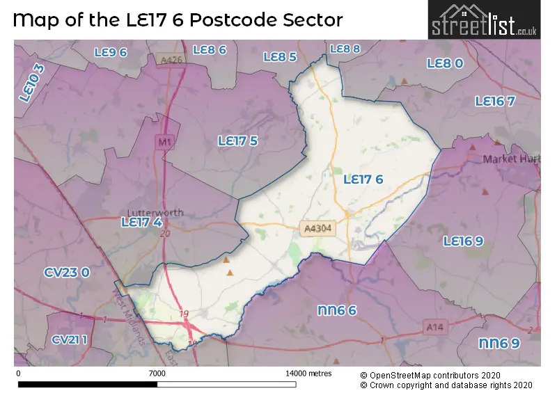
The LE17 6 postcode sector lies where the three counties of Leicestershire, Northamptonshire, and Warwickshire meet.
Did you know? According to the 2021 Census, the LE17 6 postcode sector is home to a bustling 4,763 residents!
Given that each sector allows for 400 unique postcode combinations. Letters C, I, K, M, O and V are not allowed in the last two letters of a postcode. With 198 postcodes already in use, this leaves 202 units available.
The largest settlement in the LE17 6 postal code is Husbands Bosworth followed by North Kilworth, and Swinford.
The LE17 6 Postcode shares a border with NN6 6 (Welford, Naseby, Yelvertoft), LE8 0 (Kibworth Beauchamp, Kibworth Harcourt, Smeeton Westerby), LE8 5 (Countesthorpe, Arnesby, Peatling Magna), CV23 0 (RUGBY, Clifton Upon Dunsmore, Brinklow), LE8 8 (Fleckney), LE16 7 (MARKET HARBOROUGH, Great Bowden, Foxton), LE16 9 (MARKET HARBOROUGH, Lubenham, Clipston), LE17 4 (LUTTERWORTH, Bitteswell, Walcote) and LE17 5 (Gilmorton, Ullesthorpe, Dunton Bassett).
The sector is within the post town of LUTTERWORTH.
LE17 6 is a postcode sector within the LE17 postcode district which is within the LE Leicester postcode area.
The Royal Mail delivery office for the LE17 6 postal sector is the Lutterworth Delivery Office.
The area of the LE17 6 postcode sector is 33.50 square miles which is 86.77 square kilometres or 21,441.74 square acres.
The LE17 6 postcode sector is crossed by the A14 Major A road.
The LE17 6 postcode sector is crossed by the A5 Major A road.
The LE17 6 postcode sector is crossed by the M6 motorway.
The LE17 6 postcode sector is crossed by the M1 motorway.
Waterways within the LE17 6 postcode sector include the Grand Union Canal Leicester Line, Husbands Bosworth Tunnel, Grand Union Canal Welford Arm.

Map of the LE17 6 Postcode Sector
Explore the LE17 6 postcode sector by using our free interactive map.
| L | E | 1 | 7 | - | 6 | X | X |
| L | E | 1 | 7 | Space | 6 | Letter | Letter |
Official List of Streets
Husbands Bosworth (36 Streets)
Shearsby (10 Streets)
North Kilworth (23 Streets)
Theddingworth (11 Streets)
Knaptoft (4 Streets)
Shawell (9 Streets)
Swinford (20 Streets)
Mowsley (6 Streets)
South Kilworth (11 Streets)
Catthorpe (8 Streets)
Laughton (1 Streets)
Unofficial Streets or Alternative Spellings
Lubenham
LAUGHTON ROAD THEDDINGWORTH ROADArnesby
FLECKNEY LANE WELFORD ROAD BATH LANE BROMWELL GROVE BULLACES LANE BUNKERS HILL FLECKNEY ROAD GRANGE GARDENS HARBOROUGH ROAD HERMITAGE CLOSE LAUGHTON LANE MILL HILL MOWSLEY LANE RIVER AVON BRIDLEWAY SCOBOROUGH ROAD THE SPRINGS WASH PIT LANECotesbach
RUGBY ROADMarston Trussell
THEDDINGWORTH ROADSaddington
MOWSLEY ROAD SHEARSBY ROADWalton
BOSWORTH ROADWalcote
SWINFORD ROADLilbourne
STATION ROADFleckney
ARNESBY ROADBurbage
WATLING STREETWeather Forecast for LE17 6
Press Button to Show Forecast for Stanford Hall
| Time Period | Icon | Description | Temperature | Rain Probability | Wind |
|---|---|---|---|---|---|
| 09:00 to 12:00 | Partly cloudy (day) | 18.0°C (feels like 17.0°C) | 0.00% | E 9 mph | |
| 12:00 to 15:00 | Cloudy | 22.0°C (feels like 21.0°C) | 5.00% | SE 9 mph | |
| 15:00 to 18:00 | Cloudy | 23.0°C (feels like 22.0°C) | 6.00% | SSE 9 mph | |
| 18:00 to 21:00 | Partly cloudy (day) | 21.0°C (feels like 20.0°C) | 33.00% | SE 7 mph | |
| 21:00 to 00:00 | Partly cloudy (night) | 16.0°C (feels like 16.0°C) | 32.00% | ESE 7 mph |
Press Button to Show Forecast for Stanford Hall
| Time Period | Icon | Description | Temperature | Rain Probability | Wind |
|---|---|---|---|---|---|
| 00:00 to 03:00 | Clear night | 14.0°C (feels like 13.0°C) | 2.00% | SSE 7 mph | |
| 03:00 to 06:00 | Clear night | 12.0°C (feels like 11.0°C) | 2.00% | S 7 mph | |
| 06:00 to 09:00 | Overcast | 13.0°C (feels like 11.0°C) | 9.00% | SSW 9 mph | |
| 09:00 to 12:00 | Cloudy | 15.0°C (feels like 13.0°C) | 6.00% | S 11 mph | |
| 12:00 to 15:00 | Partly cloudy (day) | 19.0°C (feels like 16.0°C) | 1.00% | S 13 mph | |
| 15:00 to 18:00 | Cloudy | 19.0°C (feels like 16.0°C) | 5.00% | S 13 mph | |
| 18:00 to 21:00 | Cloudy | 17.0°C (feels like 15.0°C) | 7.00% | SSE 11 mph | |
| 21:00 to 00:00 | Cloudy | 15.0°C (feels like 13.0°C) | 11.00% | SE 9 mph |
Press Button to Show Forecast for Stanford Hall
| Time Period | Icon | Description | Temperature | Rain Probability | Wind |
|---|---|---|---|---|---|
| 00:00 to 03:00 | Light rain | 14.0°C (feels like 13.0°C) | 44.00% | SE 11 mph | |
| 03:00 to 06:00 | Light rain | 14.0°C (feels like 12.0°C) | 58.00% | ESE 11 mph | |
| 06:00 to 09:00 | Light rain | 14.0°C (feels like 12.0°C) | 60.00% | ESE 9 mph | |
| 09:00 to 12:00 | Heavy rain | 15.0°C (feels like 13.0°C) | 85.00% | ESE 11 mph | |
| 12:00 to 15:00 | Heavy rain | 16.0°C (feels like 14.0°C) | 84.00% | SSE 11 mph | |
| 15:00 to 18:00 | Light rain | 16.0°C (feels like 14.0°C) | 56.00% | SSE 11 mph | |
| 18:00 to 21:00 | Cloudy | 15.0°C (feels like 14.0°C) | 18.00% | SSE 9 mph | |
| 21:00 to 00:00 | Cloudy | 13.0°C (feels like 11.0°C) | 10.00% | SE 9 mph |
Press Button to Show Forecast for Stanford Hall
| Time Period | Icon | Description | Temperature | Rain Probability | Wind |
|---|---|---|---|---|---|
| 00:00 to 03:00 | Cloudy | 12.0°C (feels like 10.0°C) | 5.00% | SE 9 mph | |
| 03:00 to 06:00 | Partly cloudy (night) | 11.0°C (feels like 10.0°C) | 3.00% | ESE 7 mph | |
| 06:00 to 09:00 | Cloudy | 12.0°C (feels like 11.0°C) | 9.00% | ESE 7 mph | |
| 09:00 to 12:00 | Partly cloudy (day) | 15.0°C (feels like 14.0°C) | 11.00% | SE 9 mph | |
| 12:00 to 15:00 | Light rain shower (day) | 17.0°C (feels like 16.0°C) | 32.00% | SE 9 mph | |
| 15:00 to 18:00 | Partly cloudy (day) | 18.0°C (feels like 16.0°C) | 12.00% | SE 9 mph | |
| 18:00 to 21:00 | Sunny day | 17.0°C (feels like 16.0°C) | 5.00% | SE 7 mph | |
| 21:00 to 00:00 | Clear night | 12.0°C (feels like 12.0°C) | 1.00% | SE 4 mph |
Press Button to Show Forecast for Stanford Hall
| Time Period | Icon | Description | Temperature | Rain Probability | Wind |
|---|---|---|---|---|---|
| 00:00 to 03:00 | Clear night | 10.0°C (feels like 10.0°C) | 1.00% | SE 4 mph | |
| 03:00 to 06:00 | Clear night | 9.0°C (feels like 9.0°C) | 1.00% | SSE 4 mph | |
| 06:00 to 09:00 | Sunny day | 11.0°C (feels like 11.0°C) | 3.00% | E 4 mph | |
| 09:00 to 12:00 | Cloudy | 16.0°C (feels like 15.0°C) | 7.00% | E 4 mph | |
| 12:00 to 15:00 | Cloudy | 18.0°C (feels like 17.0°C) | 15.00% | SSE 4 mph | |
| 15:00 to 18:00 | Cloudy | 18.0°C (feels like 18.0°C) | 14.00% | E 4 mph | |
| 18:00 to 21:00 | Light rain shower (day) | 17.0°C (feels like 16.0°C) | 33.00% | SW 4 mph | |
| 21:00 to 00:00 | Cloudy | 13.0°C (feels like 13.0°C) | 8.00% | SW 4 mph |
Schools and Places of Education Within the LE17 6 Postcode Sector
Husbands Bosworth Church of England Primary School
Academy converter
School Lane, Lutterworth, Leicestershire, LE17 6JU
Head: Mr Alan Eathorne
Ofsted Rating: Good
Inspection: 2019-07-09 (1769 days ago)
Website: Visit Husbands Bosworth Church of England Primary School Website
Phone: 01858880212
Number of Pupils: 83
South Kilworth Church of England Primary School
Academy converter
Walcote Road, Lutterworth, Leicestershire, LE17 6EG
Head: Mrs Heather White
Ofsted Rating: Good
Inspection: 2023-06-14 (333 days ago)
Website: Visit South Kilworth Church of England Primary School Website
Phone: 01858575307
Number of Pupils: 68
St Andrew's Church of England Primary School, North Kilworth
Academy converter
Dag Lane, Lutterworth, Leicestershire, LE17 6HD
Head: Mrs Heather White
Ofsted Rating: Good
Inspection: 2019-03-07 (1893 days ago)
Website: Visit St Andrew's Church of England Primary School, North Kilworth Website
Phone: 01858880430
Number of Pupils: 81
Swinford Church of England Primary School
Academy converter
School Lane, Lutterworth, Leicestershire, LE17 6BG
Head: Co Headteacher Edy O'Connor and Rachel Chamberlain
Ofsted Rating: Good
Inspection: 2020-01-14 (1580 days ago)
Website: Visit Swinford Church of England Primary School Website
Phone: 01788860404
Number of Pupils: 103
House Prices in the LE17 6 Postcode Sector
| Type of Property | 2018 Average | 2018 Sales | 2017 Average | 2017 Sales | 2016 Average | 2016 Sales | 2015 Average | 2015 Sales |
|---|---|---|---|---|---|---|---|---|
| Detached | £420,116 | 55 | £491,672 | 29 | £453,957 | 33 | £407,500 | 34 |
| Semi-Detached | £268,087 | 23 | £229,573 | 13 | £264,868 | 11 | £253,746 | 14 |
| Terraced | £210,129 | 17 | £195,550 | 14 | £214,023 | 20 | £192,056 | 16 |
| Flats | £115,988 | 4 | £95,500 | 2 | £265,000 | 2 | £116,158 | 6 |
Important Postcodes LE17 6 in the Postcode Sector
LE17 6BG is the postcode for Swinford C of E Primary School, School Lane
LE17 6HD is the postcode for St Andrews C Of E Primary School, Dag Lane
LE17 6JU is the postcode for Husbands Bosworth C of E Primary School, School Lane
| The LE17 6 Sector is within these Local Authorities |
|
|---|---|
| The LE17 6 Sector is within these Counties |
|
| The LE17 6 Sector is within these Water Company Areas |
|