The LE67 2 postcode sector is within the county of Leicestershire.
Did you know? According to the 2021 Census, the LE67 2 postcode sector is home to a bustling 9,273 residents!
Given that each sector allows for 400 unique postcode combinations. Letters C, I, K, M, O and V are not allowed in the last two letters of a postcode. With 220 postcodes already in use, this leaves 180 units available.
The largest settlement in the LE67 2 postal code is Hugglescote followed by Ravenstone, and Heather.
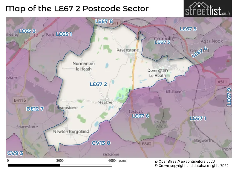
The LE67 2 Postcode shares a border with CV13 0 (Market Bosworth, Barlestone, Nailstone), DE12 7 (Measham, Donisthorpe, Appleby Magna), LE67 8 (Thringstone, Coleorton, Swannington), LE65 1 (ASHBY-DE-LA-ZOUCH, Packington, Worthington), LE67 1 (Ellistown, Bagworth, Thornton), LE67 3 (COALVILLE, Sinope), LE67 4 (COALVILLE) and LE67 6 (IBSTOCK).
The sector is within the post town of COALVILLE.
LE67 2 is a postcode sector within the LE67 postcode district which is within the LE Leicester postcode area.
The Royal Mail delivery office for the LE67 2 postal sector is the Coalville Delivery Office.
The area of the LE67 2 postcode sector is 10.66 square miles which is 27.61 square kilometres or 6,822.23 square acres.

Map of the LE67 2 Postcode Sector
Explore the LE67 2 postcode sector by using our free interactive map.
| L | E | 6 | 7 | - | 2 | X | X |
| L | E | 6 | 7 | Space | 2 | Letter | Letter |
Official List of Streets
Ravenstone (54 Streets)
Hugglescote (91 Streets)
Normanton Le Heath (7 Streets)
Heather (22 Streets)
Donington Le Heath (14 Streets)
Swepstone (5 Streets)
Unofficial Streets or Alternative Spellings
Bardon Hill
GRANGE ROADIBSTOCK
ASHBY ROAD BLACKBERRY LANE RAVENSTONE ROAD STATION ROADOdstone
NEWTON LANECOALVILLE
APPLETREE CLOSE ASHLAND DRIVE BELVOIR ROAD BUCKTHORN ROAD CHOYCE CLOSE FOREST ROAD GLEBE VIEW HEMLOCK ROAD HIGHFIELD STREET LARCH DRIVE NORTH AVENUE RAVENSTONE ROAD STANDARD HILL SWANNINGTON ROADColeorton
ASHBY ROADSinope
ASHBY ROADEllistown
MIDLAND ROADShackerstone
DERBY LANEWeather Forecast for LE67 2
Press Button to Show Forecast for Coalville
| Time Period | Icon | Description | Temperature | Rain Probability | Wind |
|---|---|---|---|---|---|
| 06:00 to 09:00 | Cloudy | 4.0°C (feels like 1.0°C) | 8.00% | NE 9 mph | |
| 09:00 to 12:00 | Cloudy | 7.0°C (feels like 3.0°C) | 20.00% | ENE 11 mph | |
| 12:00 to 15:00 | Light rain | 7.0°C (feels like 4.0°C) | 58.00% | ENE 11 mph | |
| 15:00 to 18:00 | Overcast | 7.0°C (feels like 4.0°C) | 18.00% | ENE 11 mph | |
| 18:00 to 21:00 | Overcast | 7.0°C (feels like 3.0°C) | 20.00% | NE 13 mph | |
| 21:00 to 00:00 | Overcast | 6.0°C (feels like 2.0°C) | 15.00% | NE 11 mph |
Press Button to Show Forecast for Coalville
| Time Period | Icon | Description | Temperature | Rain Probability | Wind |
|---|---|---|---|---|---|
| 00:00 to 03:00 | Overcast | 5.0°C (feels like 1.0°C) | 14.00% | NNE 13 mph | |
| 03:00 to 06:00 | Drizzle | 5.0°C (feels like 1.0°C) | 34.00% | NNE 13 mph | |
| 06:00 to 09:00 | Light rain | 5.0°C (feels like 1.0°C) | 54.00% | N 13 mph | |
| 09:00 to 12:00 | Heavy rain | 6.0°C (feels like 2.0°C) | 74.00% | NNW 11 mph | |
| 12:00 to 15:00 | Light rain | 8.0°C (feels like 5.0°C) | 51.00% | NW 11 mph | |
| 15:00 to 18:00 | Light rain | 9.0°C (feels like 7.0°C) | 45.00% | WNW 9 mph | |
| 18:00 to 21:00 | Sunny day | 9.0°C (feels like 7.0°C) | 6.00% | W 9 mph | |
| 21:00 to 00:00 | Clear night | 6.0°C (feels like 4.0°C) | 4.00% | SW 7 mph |
Press Button to Show Forecast for Coalville
| Time Period | Icon | Description | Temperature | Rain Probability | Wind |
|---|---|---|---|---|---|
| 00:00 to 03:00 | Clear night | 5.0°C (feels like 2.0°C) | 1.00% | SSW 7 mph | |
| 03:00 to 06:00 | Clear night | 3.0°C (feels like 1.0°C) | 1.00% | SSW 7 mph | |
| 06:00 to 09:00 | Sunny day | 5.0°C (feels like 2.0°C) | 2.00% | S 7 mph | |
| 09:00 to 12:00 | Partly cloudy (day) | 10.0°C (feels like 7.0°C) | 1.00% | S 11 mph | |
| 12:00 to 15:00 | Cloudy | 12.0°C (feels like 9.0°C) | 7.00% | S 13 mph | |
| 15:00 to 18:00 | Partly cloudy (day) | 13.0°C (feels like 10.0°C) | 4.00% | S 13 mph | |
| 18:00 to 21:00 | Partly cloudy (day) | 12.0°C (feels like 10.0°C) | 4.00% | S 11 mph | |
| 21:00 to 00:00 | Clear night | 9.0°C (feels like 7.0°C) | 3.00% | SSE 9 mph |
Press Button to Show Forecast for Coalville
| Time Period | Icon | Description | Temperature | Rain Probability | Wind |
|---|---|---|---|---|---|
| 00:00 to 03:00 | Clear night | 7.0°C (feels like 5.0°C) | 3.00% | SSE 9 mph | |
| 03:00 to 06:00 | Clear night | 6.0°C (feels like 4.0°C) | 3.00% | SE 9 mph | |
| 06:00 to 09:00 | Partly cloudy (day) | 7.0°C (feels like 5.0°C) | 4.00% | ESE 9 mph | |
| 09:00 to 12:00 | Sunny day | 12.0°C (feels like 9.0°C) | 4.00% | ESE 11 mph | |
| 12:00 to 15:00 | Partly cloudy (day) | 15.0°C (feels like 12.0°C) | 8.00% | SE 11 mph | |
| 15:00 to 18:00 | Partly cloudy (day) | 15.0°C (feels like 13.0°C) | 10.00% | SE 11 mph | |
| 18:00 to 21:00 | Cloudy | 14.0°C (feels like 12.0°C) | 10.00% | ESE 9 mph | |
| 21:00 to 00:00 | Cloudy | 11.0°C (feels like 9.0°C) | 9.00% | E 7 mph |
Schools and Places of Education Within the LE67 2 Postcode Sector
Heather Primary School
Community school
Main Street, Coalville, Leicestershire, LE67 2QP
Head: Mrs Maxine Michalowski
Ofsted Rating: Requires improvement
Inspection: 2022-02-10 (807 days ago)
Website: Visit Heather Primary School Website
Phone: 01530260257
Number of Pupils: 116
Hugglescote Community Primary School
Community school
Ashburton Road, Coalville, Leicestershire, LE67 2HA
Head: Mr Paul Driver
Ofsted Rating: Good
Inspection: 2022-10-27 (548 days ago)
Website: Visit Hugglescote Community Primary School Website
Phone: 01530832721
Number of Pupils: 462
Newton Burgoland Primary School
Community school
School Lane, Coalville, Leicestershire, LE67 2SL
Head: Mrs Sue Ward
Ofsted Rating: Outstanding
Inspection: 2011-10-27 (4566 days ago)
Website: Visit Newton Burgoland Primary School Website
Phone: 01530270320
Number of Pupils: 81
Woodstone Community Primary School
Community school
Heather Lane, Coalville, Leicestershire, LE67 2AH
Head: Mr Patrick Mullins
Ofsted Rating: Good
Inspection: 2019-10-09 (1662 days ago)
Website: Visit Woodstone Community Primary School Website
Phone: 01530519473
Number of Pupils: 210
House Prices in the LE67 2 Postcode Sector
| Type of Property | 2018 Average | 2018 Sales | 2017 Average | 2017 Sales | 2016 Average | 2016 Sales | 2015 Average | 2015 Sales |
|---|---|---|---|---|---|---|---|---|
| Detached | £294,548 | 164 | £287,094 | 141 | £278,349 | 102 | £223,513 | 57 |
| Semi-Detached | £187,589 | 74 | £164,912 | 60 | £165,445 | 48 | £160,240 | 41 |
| Terraced | £144,891 | 48 | £132,764 | 51 | £117,603 | 47 | £112,532 | 36 |
| Flats | £125,000 | 2 | £64,950 | 1 | £58,975 | 2 | £0 | 0 |
Important Postcodes LE67 2 in the Postcode Sector
LE67 2AH is the postcode for Woodstone Community Primary School, Heather Lane, Ravenstone, and Woodstone Community Primary School, Heather Lane
LE67 2BS is the postcode for Hugglescote Surgery, 151 Grange Road
LE67 2HA is the postcode for HUGGLESCOTE COUNTY PRIMARY SCHOOL, ASHBURTON ROAD, HUGGLESCOTE, Hugglescote County Primary School, Ashburton Road, and Hugglescote County School, Ashburton Road
LE67 2SL is the postcode for Newton Burgoland Cp School, School Lane
| The LE67 2 Sector is within these Local Authorities |
|
|---|---|
| The LE67 2 Sector is within these Counties |
|
| The LE67 2 Sector is within these Water Company Areas |
|
Tourist Attractions within the LE67 2 Postcode Area
We found 1 visitor attractions within the LE67 postcode area
| Donington le Heath Manor House |
|---|
| Museums & Art Galleries |
| Museum and / or Art Gallery |
| View Donington le Heath Manor House on Google Maps |