The LS16 8 postcode sector is within the county of West Yorkshire.
Did you know? According to the 2021 Census, the LS16 8 postcode sector is home to a bustling 4,943 residents!
Given that each sector allows for 400 unique postcode combinations. Letters C, I, K, M, O and V are not allowed in the last two letters of a postcode. With 170 postcodes already in use, this leaves 230 units available.
The largest settlement in the LS16 8 postal code is LEEDS followed by Adel, and Eccup.
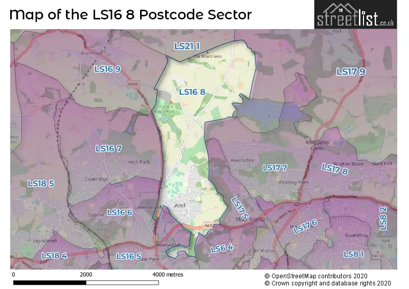
The LS16 8 Postcode shares a border with LS6 4 (LEEDS, Meanwood), LS16 7 (LEEDS, Cookridge), LS16 9 (Bramhope), LS17 5 (LEEDS, Moortown), LS21 1 (OTLEY, Pool In Wharfedale, Arthington), LS16 5 (LEEDS, West Park, Weetwood), LS16 6 (LEEDS, Adel, West Park), LS17 7 (LEEDS, Alwoodley) and LS17 9 (Bardsey, Harewood, East Keswick).
The sector is within the post town of LEEDS.
LS16 8 is a postcode sector within the LS1 postcode district which is within the LS Leeds postcode area.
The Royal Mail delivery office for the LS16 8 postal sector is the Leeds City Delivery Office.
The area of the LS16 8 postcode sector is 3.53 square miles which is 9.15 square kilometres or 2,261.36 square acres.

Map of the LS16 8 Postcode Sector
Explore the LS16 8 postcode sector by using our free interactive map.
| L | S | 1 | 6 | - | 8 | X | X |
| L | S | 1 | 6 | Space | 8 | Letter | Letter |
Official List of Streets
LEEDS (112 Streets)
Adel (12 Streets)
Eccup (2 Streets)
Unofficial Streets or Alternative Spellings
LEEDS
CRAG LANE HOLT LANE KINGSLEY DRIVE NEW ADEL LANEHeadingley
OTLEY ROADBramhope
ARTHINGTON ROAD KINGS ROADMoortown
KING LANESchools and Places of Education Within the LS16 8 Postcode Sector
Adel Primary School
Community school
Tile Lane, Leeds, West Yorkshire, LS16 8DY
Head: Mrs Julie Cordingley
Ofsted Rating: Good
Inspection: 2022-01-26 (861 days ago)
Website: Visit Adel Primary School Website
Phone: 01132301116
Number of Pupils: 234
Adel St John the Baptist Church of England Primary School
Voluntary aided school
Long Causeway, Leeds, West Yorkshire, LS16 8EX
Head: Mr Peter Dalrymple
Ofsted Rating: Good
Inspection: 2020-01-30 (1588 days ago)
Website: Visit Adel St John the Baptist Church of England Primary School Website
Phone: 01132611804
Number of Pupils: 207
House Prices in the LS16 8 Postcode Sector
| Type of Property | 2018 Average | 2018 Sales | 2017 Average | 2017 Sales | 2016 Average | 2016 Sales | 2015 Average | 2015 Sales |
|---|---|---|---|---|---|---|---|---|
| Detached | £557,814 | 91 | £529,355 | 72 | £453,355 | 73 | £520,798 | 64 |
| Semi-Detached | £203,939 | 9 | £332,150 | 10 | £307,772 | 9 | £332,241 | 6 |
| Terraced | £211,494 | 9 | £152,997 | 16 | £202,340 | 20 | £252,217 | 9 |
| Flats | £138,888 | 9 | £175,077 | 26 | £183,300 | 15 | £114,583 | 6 |
Important Postcodes LS16 8 in the Postcode Sector
LS16 8DY is the postcode for Adel Primary School, Tile Lane
LS16 8EB is the postcode for East Moor Secure Childrens Centre, East Moor Lane
LS16 8EX is the postcode for Adel St. John the Baptist C of E Primary School, Long Causeway, and Adel St Johns The Baptist Church Of England Primary School, Long Causeway, Adel
LS16 8NA is the postcode for The Brownlee Centre, Bodington Avenue, and The Brownlee Centre (0250), Bodington Avenue, Adel
| The LS16 8 Sector is within these Local Authorities |
|
|---|---|
| The LS16 8 Sector is within these Counties |
|
| The LS16 8 Sector is within these Water Company Areas |
|