The LS12 postcode district is a postal district located in the LS Leeds postcode area with a population of 44,185 residents according to the 2021 England and Wales Census.
The area of the LS12 postcode district is 6.73 square miles which is 17.43 square kilometres or 4,306.27 acres.
Currently, the LS12 district has about 1179 postcode units spread across 6 geographic postcode sectors.
Given that each sector allows for 400 unique postcode combinations, the district has a capacity of 2,400 postcodes. With 1179 postcodes already in use, this leaves 1221 units available.
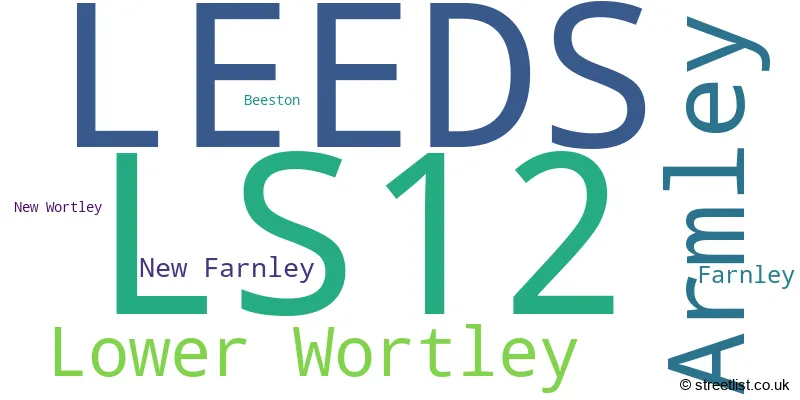
The largest settlements in the LS12 postal code are LEEDS and Armley.
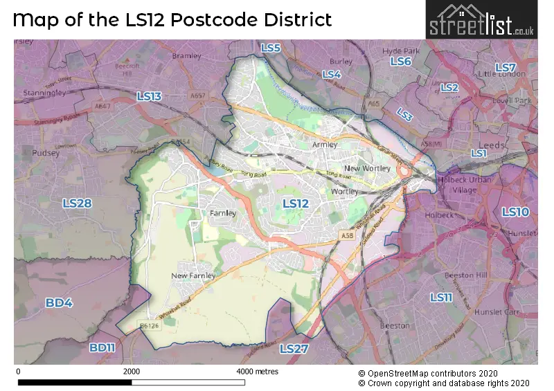
The LS12 Postcode shares a border with LS11 (LEEDS, Beeston), BD4 (BRADFORD, Laisterdyke, Bierley), LS27 (Morley), LS28 (PUDSEY, Farsley, Stanningley), LS5 (LEEDS, Kirkstall), LS13 (LEEDS, Bramley, Rodley) and LS4 (LEEDS).
The primary settlement in the LS12 postcode district is Leeds, which is located in the county of West Yorkshire, England. Other significant settlements in the district include Armley, New Wortley, Lower Wortley, Farnley, Beeston, and New Farnley. The most significant post town in the LS12 postcode district is Leeds.
For the district LS12, we have data on 7 postcode sectors. Here's a breakdown: The sector LS12 1, covers Leeds in West Yorkshire. The sector LS12 2, covers Leeds in West Yorkshire. The sector LS12 3, covers Leeds and Armley in West Yorkshire. The sector LS12 4, covers Leeds in West Yorkshire. The sector LS12 5, covers Leeds in West Yorkshire. The sector LS12 6, covers Leeds in West Yorkshire. The sector LS12 9 is non-geographic. It's often designated for PO Boxes, large organisations, or special services.

Map of the LS12 Postcode District
Explore the LS12 postcode district by using our free interactive map.
When it comes to local government, postal geography often disregards political borders. However, for a breakdown in the LS12 District: the district mostly encompasses the Leeds District (B) area with a total of 1206 postcodes.
Recent House Sales in LS12
| Date | Price | Address |
|---|---|---|
| 19/10/2023 | £91,500 | Arley Terrace, Armley, Leeds, LS12 2PA |
| 13/10/2023 | £59,500 | Gilpin View, Leeds, LS12 1HJ |
| 06/10/2023 | £128,000 | Hill End Crescent, Leeds, LS12 3PW |
| 27/09/2023 | £249,995 | Blue Hill Lane, Leeds, LS12 4NT |
| 25/09/2023 | £130,000 | Aviary Road, Leeds, LS12 2NS |
| 22/09/2023 | £125,000 | Edinburgh Terrace, Leeds, LS12 3RH |
| 18/09/2023 | £160,000 | Salisbury Terrace, Leeds, LS12 2AY |
| 15/09/2023 | £50,000 | Wensleydale Rise, Leeds, LS12 2HX |
| 15/09/2023 | £250,000 | Heaton Avenue, Leeds, LS12 4AE |
| 15/09/2023 | £205,000 | Highfield Close, Leeds, LS12 4BB |
Weather Forecast for LS12
Press Button to Show Forecast for Wortley
| Time Period | Icon | Description | Temperature | Rain Probability | Wind |
|---|---|---|---|---|---|
| 12:00 to 15:00 | Overcast | 9.0°C (feels like 7.0°C) | 50.00% | ENE 9 mph | |
| 15:00 to 18:00 | Overcast | 9.0°C (feels like 6.0°C) | 50.00% | NE 9 mph | |
| 18:00 to 21:00 | Overcast | 8.0°C (feels like 6.0°C) | 21.00% | ENE 9 mph | |
| 21:00 to 00:00 | Cloudy | 7.0°C (feels like 4.0°C) | 7.00% | NE 7 mph |
Press Button to Show Forecast for Wortley
| Time Period | Icon | Description | Temperature | Rain Probability | Wind |
|---|---|---|---|---|---|
| 00:00 to 03:00 | Cloudy | 5.0°C (feels like 3.0°C) | 5.00% | NNE 7 mph | |
| 03:00 to 06:00 | Cloudy | 5.0°C (feels like 2.0°C) | 11.00% | N 9 mph | |
| 06:00 to 09:00 | Light rain | 6.0°C (feels like 2.0°C) | 50.00% | N 11 mph | |
| 09:00 to 12:00 | Light rain | 7.0°C (feels like 3.0°C) | 51.00% | N 11 mph | |
| 12:00 to 15:00 | Light rain | 8.0°C (feels like 5.0°C) | 50.00% | NW 11 mph | |
| 15:00 to 18:00 | Light rain | 10.0°C (feels like 8.0°C) | 46.00% | WNW 9 mph | |
| 18:00 to 21:00 | Partly cloudy (day) | 10.0°C (feels like 8.0°C) | 6.00% | W 9 mph | |
| 21:00 to 00:00 | Clear night | 8.0°C (feels like 5.0°C) | 2.00% | WSW 7 mph |
Press Button to Show Forecast for Wortley
| Time Period | Icon | Description | Temperature | Rain Probability | Wind |
|---|---|---|---|---|---|
| 00:00 to 03:00 | Partly cloudy (night) | 6.0°C (feels like 4.0°C) | 1.00% | SW 7 mph | |
| 03:00 to 06:00 | Clear night | 5.0°C (feels like 3.0°C) | 1.00% | SSW 7 mph | |
| 06:00 to 09:00 | Sunny day | 6.0°C (feels like 4.0°C) | 1.00% | S 7 mph | |
| 09:00 to 12:00 | Partly cloudy (day) | 11.0°C (feels like 8.0°C) | 2.00% | S 9 mph | |
| 12:00 to 15:00 | Cloudy | 13.0°C (feels like 11.0°C) | 6.00% | S 13 mph | |
| 15:00 to 18:00 | Cloudy | 14.0°C (feels like 11.0°C) | 7.00% | S 13 mph | |
| 18:00 to 21:00 | Partly cloudy (day) | 13.0°C (feels like 11.0°C) | 4.00% | S 11 mph | |
| 21:00 to 00:00 | Clear night | 11.0°C (feels like 9.0°C) | 2.00% | SSE 9 mph |
Press Button to Show Forecast for Wortley
| Time Period | Icon | Description | Temperature | Rain Probability | Wind |
|---|---|---|---|---|---|
| 00:00 to 03:00 | Clear night | 9.0°C (feels like 7.0°C) | 2.00% | SSE 7 mph | |
| 03:00 to 06:00 | Partly cloudy (night) | 7.0°C (feels like 5.0°C) | 2.00% | SE 7 mph | |
| 06:00 to 09:00 | Sunny day | 7.0°C (feels like 5.0°C) | 3.00% | ESE 7 mph | |
| 09:00 to 12:00 | Cloudy | 11.0°C (feels like 9.0°C) | 7.00% | ESE 9 mph | |
| 12:00 to 15:00 | Partly cloudy (day) | 15.0°C (feels like 13.0°C) | 5.00% | ESE 11 mph | |
| 15:00 to 18:00 | Partly cloudy (day) | 16.0°C (feels like 13.0°C) | 9.00% | ESE 11 mph | |
| 18:00 to 21:00 | Partly cloudy (day) | 14.0°C (feels like 12.0°C) | 7.00% | ESE 9 mph | |
| 21:00 to 00:00 | Cloudy | 12.0°C (feels like 10.0°C) | 8.00% | E 7 mph |
Where is the LS12 Postcode District?
The LS12 postcode district is located in the town of Leeds. It is situated nearby several towns, including Pudsey to the west, Batley to the south, Heckmondwike to the southwest, and Shipley to the northwest. Additionally, the distance from LS12 to the center of London is approximately 169.34 miles.
The district is within the post town of LEEDS.
The sector has postcodes within the nation of England.
The LS12 Postcode District is in the Leeds region of West Yorkshire within the Yorkshire and The Humber.
| Postcode Sector | Delivery Office |
|---|---|
| LS12 1 | Tong Road Delivery Office |
| LS12 2 | Tong Road Delivery Office |
| LS12 3 | Tong Road Delivery Office |
| LS12 4 | Tong Road Delivery Office |
| LS12 5 | Tong Road Delivery Office |
| LS12 6 | Tong Road Delivery Office |
| L | S | 1 | 2 | - | X | X | X |
| L | S | 1 | 2 | Space | Numeric | Letter | Letter |
Tourist Attractions within the Postcode Area
We found 1 visitor attractions within the LS12 postcode area
| Leeds Industrial Museum at Armley Mills |
|---|
| Museums & Art Galleries |
| Museum and / or Art Gallery |
| View Leeds Industrial Museum at Armley Mills on Google Maps |
Current Monthly Rental Prices
| # Bedrooms | Min Price | Max Price | Avg Price |
|---|---|---|---|
| £700 | £700 | £700 | |
| 1 | £350 | £1,157 | £673 |
| 2 | £695 | £1,525 | £893 |
| 3 | £780 | £2,175 | £1,151 |
| 4 | £1,100 | £1,395 | £1,282 |
Current House Prices
| # Bedrooms | Min Price | Max Price | Avg Price |
|---|---|---|---|
| £79,000 | £240,000 | £133,000 | |
| 1 | £60,000 | £165,000 | £100,526 |
| 2 | £65,000 | £455,600 | £158,977 |
| 3 | £75,000 | £899,995 | £237,470 |
| 4 | £110,000 | £499,995 | £351,266 |
| 5 | £290,000 | £525,000 | £416,658 |
| 6 | £539,995 | £539,995 | £539,995 |
| 7 | £849,999 | £849,999 | £849,999 |
Estate Agents who Operate in the LS12 District
| Logo | Name | Brand Name | Address | Contact Number | Total Properties |
|---|---|---|---|---|---|
 | Wortley | Manning Stainton | 134/136 Lower Wortley Road, Leeds, LS12 4PQ | 0113 519 1788 | 70 |
 | Wortley | Kath Wells Estate Agents | 69 Lower Wortley Road, Leeds, LS12 4SL | 0113 519 3022 | 23 |
 | Pudsey | William H. Brown | 4-6 Church Lane, Pudsey, LS28 7BD | 0113 519 0572 | 13 |
 | covering Leeds | Purplebricks | Suite 7 First Floor Cranmore Drive Shirley Solihull B90 4RZ | 0113 519 9101 | 12 |
 | Pudsey | Hunters | 11 Church Lane, Pudsey, LS28 7LD | 0113 487 2341 | 9 |
| Type of Property | 2018 Average | 2018 Sales | 2017 Average | 2017 Sales | 2016 Average | 2016 Sales | 2015 Average | 2015 Sales |
|---|---|---|---|---|---|---|---|---|
| Detached | £241,235 | 67 | £232,893 | 54 | £218,570 | 54 | £213,691 | 56 |
| Semi-Detached | £157,417 | 240 | £148,604 | 251 | £147,067 | 225 | £128,372 | 177 |
| Terraced | £110,927 | 317 | £106,863 | 316 | £116,652 | 427 | £107,075 | 317 |
| Flats | £105,004 | 114 | £90,527 | 154 | £98,987 | 94 | £89,999 | 77 |