The LS13 1 postcode sector is within the county of West Yorkshire.
Did you know? According to the 2021 Census, the LS13 1 postcode sector is home to a bustling 7,352 residents!
Given that each sector allows for 400 unique postcode combinations. Letters C, I, K, M, O and V are not allowed in the last two letters of a postcode. With 187 postcodes already in use, this leaves 213 units available.
The largest settlements in the LS13 1 postal code are LEEDS and Rodley.
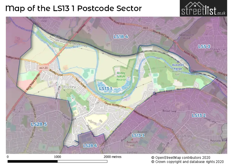
The LS13 1 Postcode shares a border with LS5 3 (LEEDS, Kirkstall), LS28 5 (Farsley, Calverley, PUDSEY), LS13 2 (LEEDS, Bramley), LS13 3 (LEEDS, Bramley), LS18 4 (Horsforth, LEEDS) and LS28 6 (Stanningley, PUDSEY).
The sector is within the post town of LEEDS.
LS13 1 is a postcode sector within the LS13 postcode district which is within the LS Leeds postcode area.
The Royal Mail delivery office for the LS13 1 postal sector is the Bramley Delivery Office.
The area of the LS13 1 postcode sector is 1.73 square miles which is 4.49 square kilometres or 1,109.78 square acres.
Waterways within the LS13 1 postcode sector include the River Aire, Leeds and Liverpool Canal.

Map of the LS13 1 Postcode Sector
Explore the LS13 1 postcode sector by using our free interactive map.
| L | S | 1 | 3 | - | 1 | X | X |
| L | S | 1 | 3 | Space | 1 | Letter | Letter |
Official List of Streets
LEEDS (111 Streets)
Rodley (26 Streets)
Unofficial Streets or Alternative Spellings
LEEDS
BRAMSTAN CLOSE BRAMSTAN GARDENS CAMBRIDGE GARDENS FALL PARK COURT GANNERS HILL MILL LANE NORA PLACE NORA TERRACE WHITECOTE HILL AIRE VALLEY TOWPATH BACK ERIC STREET BACK POLLARD LANE CROSS ERIC STREET ELLIOTT COURT FERNBANK MOSS BRIDGE NEWLAY BRIDGE OWL BRIDGE RING ROAD FARSLEY RODLEY WHARF VISITOR MOORINGSKirkstall
GREAT EXHIBITION WAYHorsforth
BROADWAY CALVERLEY LANE MANOR MEWSRodley
PROSPECT VIEWStanningley
FERN LEA VIEW GLENLEA CLOSE HALF MILE LANEFarsley
BAGLEY LANE COAL HILL LANE POPLAR FARM LANECalverley
CALVERLEY LANE RODLEY LANEWeather Forecast for LS13 1
Press Button to Show Forecast for Whitecote
| Time Period | Icon | Description | Temperature | Rain Probability | Wind |
|---|---|---|---|---|---|
| 03:00 to 06:00 | Cloudy | 3.0°C (feels like 1.0°C) | 3.00% | NNE 7 mph | |
| 06:00 to 09:00 | Cloudy | 4.0°C (feels like 1.0°C) | 4.00% | NNE 7 mph | |
| 09:00 to 12:00 | Cloudy | 8.0°C (feels like 5.0°C) | 10.00% | NE 9 mph | |
| 12:00 to 15:00 | Overcast | 9.0°C (feels like 7.0°C) | 20.00% | NE 9 mph | |
| 15:00 to 18:00 | Light rain | 9.0°C (feels like 6.0°C) | 49.00% | NE 9 mph | |
| 18:00 to 21:00 | Cloudy | 8.0°C (feels like 6.0°C) | 14.00% | ENE 9 mph | |
| 21:00 to 00:00 | Cloudy | 6.0°C (feels like 4.0°C) | 7.00% | NE 7 mph |
Press Button to Show Forecast for Whitecote
| Time Period | Icon | Description | Temperature | Rain Probability | Wind |
|---|---|---|---|---|---|
| 00:00 to 03:00 | Cloudy | 5.0°C (feels like 3.0°C) | 5.00% | NNE 7 mph | |
| 03:00 to 06:00 | Cloudy | 5.0°C (feels like 2.0°C) | 7.00% | N 9 mph | |
| 06:00 to 09:00 | Light rain | 6.0°C (feels like 3.0°C) | 49.00% | N 11 mph | |
| 09:00 to 12:00 | Light rain | 7.0°C (feels like 4.0°C) | 51.00% | N 11 mph | |
| 12:00 to 15:00 | Light rain | 8.0°C (feels like 6.0°C) | 50.00% | NW 11 mph | |
| 15:00 to 18:00 | Light rain | 10.0°C (feels like 8.0°C) | 45.00% | WNW 9 mph | |
| 18:00 to 21:00 | Partly cloudy (day) | 10.0°C (feels like 8.0°C) | 7.00% | W 9 mph | |
| 21:00 to 00:00 | Clear night | 7.0°C (feels like 5.0°C) | 1.00% | WSW 7 mph |
Press Button to Show Forecast for Whitecote
| Time Period | Icon | Description | Temperature | Rain Probability | Wind |
|---|---|---|---|---|---|
| 00:00 to 03:00 | Clear night | 6.0°C (feels like 4.0°C) | 1.00% | SW 7 mph | |
| 03:00 to 06:00 | Clear night | 5.0°C (feels like 3.0°C) | 1.00% | SSW 7 mph | |
| 06:00 to 09:00 | Sunny day | 6.0°C (feels like 4.0°C) | 1.00% | S 7 mph | |
| 09:00 to 12:00 | Partly cloudy (day) | 11.0°C (feels like 8.0°C) | 2.00% | S 11 mph | |
| 12:00 to 15:00 | Cloudy | 13.0°C (feels like 11.0°C) | 5.00% | S 13 mph | |
| 15:00 to 18:00 | Cloudy | 14.0°C (feels like 11.0°C) | 7.00% | S 13 mph | |
| 18:00 to 21:00 | Partly cloudy (day) | 13.0°C (feels like 11.0°C) | 5.00% | SSE 11 mph | |
| 21:00 to 00:00 | Clear night | 11.0°C (feels like 9.0°C) | 2.00% | SE 9 mph |
Press Button to Show Forecast for Whitecote
| Time Period | Icon | Description | Temperature | Rain Probability | Wind |
|---|---|---|---|---|---|
| 00:00 to 03:00 | Clear night | 9.0°C (feels like 7.0°C) | 2.00% | SE 9 mph | |
| 03:00 to 06:00 | Partly cloudy (night) | 7.0°C (feels like 5.0°C) | 2.00% | SE 7 mph | |
| 06:00 to 09:00 | Sunny day | 7.0°C (feels like 5.0°C) | 4.00% | ESE 7 mph | |
| 09:00 to 12:00 | Cloudy | 11.0°C (feels like 10.0°C) | 8.00% | ESE 9 mph | |
| 12:00 to 15:00 | Partly cloudy (day) | 15.0°C (feels like 13.0°C) | 6.00% | ESE 11 mph | |
| 15:00 to 18:00 | Partly cloudy (day) | 16.0°C (feels like 13.0°C) | 8.00% | ESE 11 mph | |
| 18:00 to 21:00 | Partly cloudy (day) | 14.0°C (feels like 12.0°C) | 8.00% | E 9 mph | |
| 21:00 to 00:00 | Cloudy | 11.0°C (feels like 10.0°C) | 9.00% | E 7 mph |
Schools and Places of Education Within the LS13 1 Postcode Sector
Leeds West Academy
Academy sponsor led
Intake Lane, Leeds, West Yorkshire, LS13 1DQ
Head: Mr Dan Whieldon
Ofsted Rating: Good
Inspection: 2019-05-15 (1809 days ago)
Website: Visit Leeds West Academy Website
Phone: 01132295454
Number of Pupils: 1407
Summerfield Primary School
Community school
Intake Lane, Leeds, West Yorkshire, LS13 1DQ
Head: Mrs Fiona Kirkwood
Ofsted Rating: Good
Inspection: 2023-12-07 (142 days ago)
Website: Visit Summerfield Primary School Website
Phone: 01132057520
Number of Pupils: 217
Valley View Community Primary School
Community school
Coal Hill Drive, Leeds, West Yorkshire, LS13 1DD
Head: Mrs Sarah Griggs, Mrs Claire Griffiths
Ofsted Rating: Good
Inspection: 2019-10-17 (1654 days ago)
Website: Visit Valley View Community Primary School Website
Phone: 01132554972
Number of Pupils: 458
House Prices in the LS13 1 Postcode Sector
| Type of Property | 2018 Average | 2018 Sales | 2017 Average | 2017 Sales | 2016 Average | 2016 Sales | 2015 Average | 2015 Sales |
|---|---|---|---|---|---|---|---|---|
| Detached | £338,231 | 13 | £268,000 | 17 | £229,962 | 13 | £219,333 | 18 |
| Semi-Detached | £186,812 | 63 | £164,866 | 69 | £154,477 | 54 | £159,263 | 49 |
| Terraced | £176,944 | 63 | £169,102 | 69 | £166,331 | 75 | £164,006 | 74 |
| Flats | £116,052 | 32 | £109,846 | 22 | £101,192 | 31 | £110,120 | 27 |
Important Postcodes LS13 1 in the Postcode Sector
LS13 1AH is the postcode for Leeds West Academy, Calverley Lane
LS13 1DD is the postcode for Valley View Primary School, Coal Hill Drive, Rodley, and Valley View Community Primary School, Coal Hill Drive
LS13 1DQ is the postcode for Leeds West Academy, Intake Lane, Leeds West Academy, Intake Lane, Rodley, Summerfield Primary School, Intake Lane, Bramley, and Summerfield Primary School, Intake Lane
| The LS13 1 Sector is within these Local Authorities |
|
|---|---|
| The LS13 1 Sector is within these Counties |
|
| The LS13 1 Sector is within these Water Company Areas |
|