The LS13 3 postcode sector is within the county of West Yorkshire.
Did you know? According to the 2021 Census, the LS13 3 postcode sector is home to a bustling 7,824 residents!
Given that each sector allows for 400 unique postcode combinations. Letters C, I, K, M, O and V are not allowed in the last two letters of a postcode. With 215 postcodes already in use, this leaves 185 units available.
The largest settlements in the LS13 3 postal code are LEEDS and Bramley.
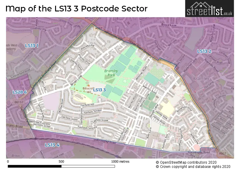
The LS13 3 Postcode shares a border with LS13 4 (LEEDS, Bramley), LS13 1 (LEEDS, Rodley), LS13 2 (LEEDS, Bramley) and LS28 6 (Stanningley, PUDSEY).
The sector is within the post town of LEEDS.
LS13 3 is a postcode sector within the LS13 postcode district which is within the LS Leeds postcode area.
The Royal Mail delivery office for the LS13 3 postal sector is the Bramley Delivery Office.
The area of the LS13 3 postcode sector is 0.51 square miles which is 1.32 square kilometres or 326.31 square acres.

Map of the LS13 3 Postcode Sector
Explore the LS13 3 postcode sector by using our free interactive map.
| L | S | 1 | 3 | - | 3 | X | X |
| L | S | 1 | 3 | Space | 3 | Letter | Letter |
Official List of Streets
LEEDS (141 Streets)
Unofficial Streets or Alternative Spellings
LEEDS
ASHLEA GATE BELL LANE BLAIRSVILLE GARDENS RODLEY LANE UPPER RODLEY LANE WATERLOO LANE WESLEY TERRACE WHITECOTE GARDENS ASHBY AVENUE ASHBY MOUNT ASHDOWN STREET BACK ATLANTA STREET BACK BATH ROAD BACK MELBOURNE GROVE BACK NANSEN STREET BACK ROSEMONT WALK BACK WESTOVER ROAD BATH GROVE DAISYFIELD ROAD FAIRFIELD VIEW HALEYS YARD HENLEY AVENUE NEW SCARBRO ROAD OSBOURNE COURT PARK VIEW ST MICHAEL COURT ST PETERS COURT STATION GROVE STOCKS HILL WARRELS ROW WESTOVER GROVE WESTOVER MOUNT WESTOVER STREET WOODBINE TERRACEStanningley
STANNINGLEY ROAD SWINNOW CRESCENT SWINNOW LANEBramley
BACK LANE MOUNT PLEASANTKirkstall
BROAD LANEWeather Forecast for LS13 3
Press Button to Show Forecast for Moorside (West Yorkshire)
| Time Period | Icon | Description | Temperature | Rain Probability | Wind |
|---|---|---|---|---|---|
| 09:00 to 12:00 | Cloudy | 6.0°C (feels like 3.0°C) | 9.00% | NNE 9 mph | |
| 12:00 to 15:00 | Cloudy | 7.0°C (feels like 6.0°C) | 10.00% | NE 7 mph | |
| 15:00 to 18:00 | Cloudy | 8.0°C (feels like 6.0°C) | 33.00% | ENE 7 mph | |
| 18:00 to 21:00 | Cloudy | 7.0°C (feels like 4.0°C) | 8.00% | E 9 mph | |
| 21:00 to 00:00 | Cloudy | 6.0°C (feels like 4.0°C) | 4.00% | E 7 mph |
Press Button to Show Forecast for Moorside (West Yorkshire)
| Time Period | Icon | Description | Temperature | Rain Probability | Wind |
|---|---|---|---|---|---|
| 00:00 to 03:00 | Cloudy | 4.0°C (feels like 2.0°C) | 3.00% | NE 4 mph | |
| 03:00 to 06:00 | Clear night | 3.0°C (feels like 0.0°C) | 1.00% | NNE 4 mph | |
| 06:00 to 09:00 | Cloudy | 3.0°C (feels like 1.0°C) | 4.00% | NNE 7 mph | |
| 09:00 to 12:00 | Cloudy | 7.0°C (feels like 5.0°C) | 10.00% | NE 9 mph | |
| 12:00 to 15:00 | Cloudy | 9.0°C (feels like 6.0°C) | 17.00% | ENE 9 mph | |
| 15:00 to 18:00 | Light rain | 8.0°C (feels like 6.0°C) | 49.00% | NE 9 mph | |
| 18:00 to 21:00 | Cloudy | 8.0°C (feels like 5.0°C) | 15.00% | ENE 9 mph | |
| 21:00 to 00:00 | Cloudy | 6.0°C (feels like 4.0°C) | 7.00% | NE 7 mph |
Press Button to Show Forecast for Moorside (West Yorkshire)
| Time Period | Icon | Description | Temperature | Rain Probability | Wind |
|---|---|---|---|---|---|
| 00:00 to 03:00 | Cloudy | 5.0°C (feels like 2.0°C) | 5.00% | NNE 7 mph | |
| 03:00 to 06:00 | Cloudy | 5.0°C (feels like 2.0°C) | 7.00% | N 9 mph | |
| 06:00 to 09:00 | Light rain | 5.0°C (feels like 2.0°C) | 47.00% | N 11 mph | |
| 09:00 to 12:00 | Light rain | 7.0°C (feels like 3.0°C) | 51.00% | N 11 mph | |
| 12:00 to 15:00 | Light rain | 8.0°C (feels like 5.0°C) | 50.00% | NW 11 mph | |
| 15:00 to 18:00 | Light rain | 10.0°C (feels like 8.0°C) | 45.00% | WNW 9 mph | |
| 18:00 to 21:00 | Partly cloudy (day) | 10.0°C (feels like 7.0°C) | 7.00% | W 9 mph | |
| 21:00 to 00:00 | Clear night | 6.0°C (feels like 4.0°C) | 1.00% | WSW 7 mph |
Press Button to Show Forecast for Moorside (West Yorkshire)
| Time Period | Icon | Description | Temperature | Rain Probability | Wind |
|---|---|---|---|---|---|
| 00:00 to 03:00 | Partly cloudy (night) | 6.0°C (feels like 3.0°C) | 1.00% | SW 7 mph | |
| 03:00 to 06:00 | Clear night | 5.0°C (feels like 2.0°C) | 1.00% | SSW 7 mph | |
| 06:00 to 09:00 | Sunny day | 5.0°C (feels like 3.0°C) | 1.00% | S 7 mph | |
| 09:00 to 12:00 | Partly cloudy (day) | 10.0°C (feels like 8.0°C) | 2.00% | S 11 mph | |
| 12:00 to 15:00 | Overcast | 13.0°C (feels like 10.0°C) | 8.00% | S 13 mph | |
| 15:00 to 18:00 | Cloudy | 14.0°C (feels like 11.0°C) | 7.00% | S 13 mph | |
| 18:00 to 21:00 | Cloudy | 13.0°C (feels like 11.0°C) | 7.00% | SSE 11 mph | |
| 21:00 to 00:00 | Clear night | 10.0°C (feels like 8.0°C) | 2.00% | SSE 9 mph |
Press Button to Show Forecast for Moorside (West Yorkshire)
| Time Period | Icon | Description | Temperature | Rain Probability | Wind |
|---|---|---|---|---|---|
| 00:00 to 03:00 | Clear night | 8.0°C (feels like 6.0°C) | 2.00% | SE 9 mph | |
| 03:00 to 06:00 | Partly cloudy (night) | 6.0°C (feels like 4.0°C) | 2.00% | SE 7 mph | |
| 06:00 to 09:00 | Sunny day | 7.0°C (feels like 5.0°C) | 4.00% | ESE 7 mph | |
| 09:00 to 12:00 | Cloudy | 11.0°C (feels like 9.0°C) | 9.00% | ESE 9 mph | |
| 12:00 to 15:00 | Partly cloudy (day) | 14.0°C (feels like 12.0°C) | 8.00% | ESE 11 mph | |
| 15:00 to 18:00 | Partly cloudy (day) | 15.0°C (feels like 13.0°C) | 8.00% | ESE 11 mph | |
| 18:00 to 21:00 | Partly cloudy (day) | 14.0°C (feels like 12.0°C) | 8.00% | E 9 mph | |
| 21:00 to 00:00 | Cloudy | 11.0°C (feels like 9.0°C) | 9.00% | E 7 mph |
Schools and Places of Education Within the LS13 3 Postcode Sector
Bramley Park Academy
Academy sponsor led
Fairfield Hill, Leeds, West Yorkshire, LS13 3DP
Head: Miss Carrie Green
Ofsted Rating: Outstanding
Inspection: 2023-03-02 (421 days ago)
Website: Visit Bramley Park Academy Website
Phone: 01132564888
Number of Pupils: 272
Bramley St Peter's Church of England Primary School
Voluntary aided school
Hough Lane, Leeds, West Yorkshire, LS13 3NE
Head: Mrs Ruth Esplin
Ofsted Rating: Good
Inspection: 2021-10-06 (933 days ago)
Website: Visit Bramley St Peter's Church of England Primary School Website
Phone: 01132559680
Number of Pupils: 399
House Prices in the LS13 3 Postcode Sector
| Type of Property | 2018 Average | 2018 Sales | 2017 Average | 2017 Sales | 2016 Average | 2016 Sales | 2015 Average | 2015 Sales |
|---|---|---|---|---|---|---|---|---|
| Detached | £210,690 | 5 | £154,492 | 6 | £247,500 | 2 | £208,750 | 4 |
| Semi-Detached | £148,670 | 42 | £149,529 | 24 | £129,963 | 24 | £125,985 | 28 |
| Terraced | £118,348 | 91 | £110,536 | 96 | £107,909 | 78 | £104,895 | 89 |
| Flats | £75,000 | 1 | £81,550 | 9 | £88,785 | 7 | £65,431 | 8 |
Important Postcodes LS13 3 in the Postcode Sector
LS13 3AA is the postcode for Bramley Fulfilling Lives, Railsfield Rise
LS13 3DF is the postcode for Bramley Baths and Community Limited, Broad Lane
LS13 3DP is the postcode for BRAMLEY PRIMARY SCHOOL, FAIRFIELD HILL, BRAMLEY, and Bramley Primary School, Fairfield Hill
LS13 3DT is the postcode for BRAMLEY CHILDRENS CENTRE, FAIRFIELD STREET, BRAMLEY
LS13 3EJ is the postcode for Bramley Clinic, 255 Town Street
LS13 3ND is the postcode for BRAMLEY LIBRARY, HOUGH LANE, BRAMLEY
LS13 3NE is the postcode for Bramley St. Peters C of E Primary School, Hough Lane
LS13 3RD is the postcode for Hough Lane Centre, Hough Lane
| The LS13 3 Sector is within these Local Authorities |
|
|---|---|
| The LS13 3 Sector is within these Counties |
|
| The LS13 3 Sector is within these Water Company Areas |
|