The LS27 7 postcode sector is within the county of West Yorkshire.
Did you know? According to the 2021 Census, the LS27 7 postcode sector is home to a bustling 10,544 residents!
Given that each sector allows for 400 unique postcode combinations. Letters C, I, K, M, O and V are not allowed in the last two letters of a postcode. With 296 postcodes already in use, this leaves 104 units available.
The LS27 7 postal code covers the settlement of Morley.
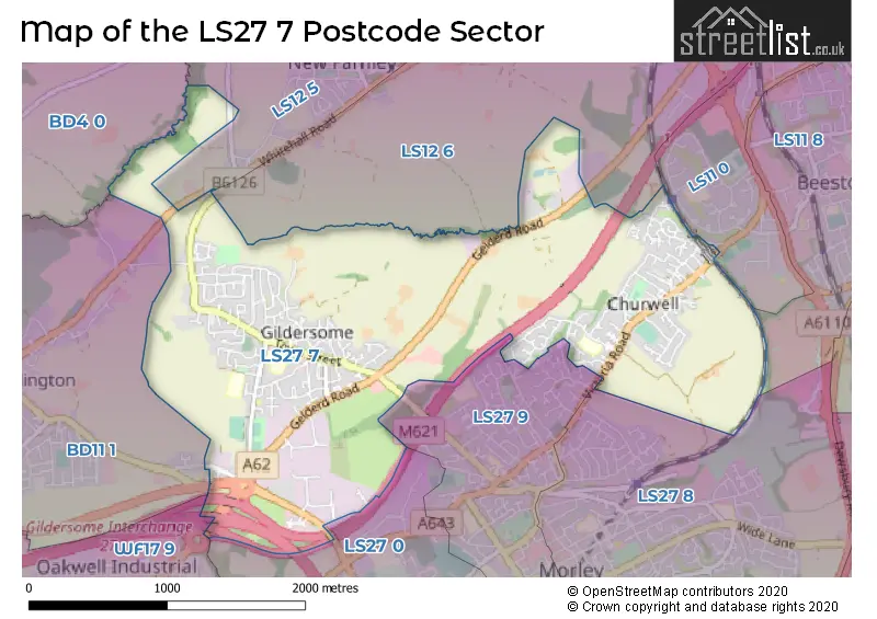
The LS27 7 Postcode shares a border with WF17 9 (Birstall, BATLEY), BD4 0 (BRADFORD, Tong, Tyersal), BD11 1 (Drighlington), LS12 5 (LEEDS, Farnley, New Farnley), LS12 6 (LEEDS, Lower Wortley, New Farnley), LS27 8 (Morley), LS11 8 (LEEDS, Beeston), LS11 0 (LEEDS), LS27 0 (Morley) and LS27 9 (Morley).
The sector is within the post town of LEEDS.
LS27 7 is a postcode sector within the LS27 postcode district which is within the LS Leeds postcode area.
The Royal Mail delivery office for the LS27 7 postal sector is the Morley Delivery Office.
The area of the LS27 7 postcode sector is 2.76 square miles which is 7.15 square kilometres or 1,767.99 square acres.
The LS27 7 postcode sector is crossed by the M62 motorway.
The LS27 7 postcode sector is crossed by the M621 motorway.
The LS27 7 postcode sector is crossed by the A62 Major A road.

Map of the LS27 7 Postcode Sector
Explore the LS27 7 postcode sector by using our free interactive map.
| L | S | 2 | 7 | - | 7 | X | X |
| L | S | 2 | 7 | Space | 7 | Letter | Letter |
Official List of Streets
Morley (189 Streets)
Unofficial Streets or Alternative Spellings
Morley
CO-OPERATIVE STREET EAST VIEW HARTHILL PARADE LANESIDE CLOSE LANESIDE GARDENS NEPSHAW LANE NORTH WESTWOOD SIDEDrighlington
NEW LANE WAKEFIELD ROAD WHITEHALL ROAD BRANCH END CHAPEL VIEW COTTINGLEY SPRINGS CROFT HOUSE WAY DEANHURT PARK FORSYTH GELDERD POINT GRANGE STREET HADLEYS COURT HARTWELL LANE MORLEY 148 MOUNT PLEASANT THE TITHINGS WEST END WESTWOODSIDELEEDS
BACK LANE OLD CLOSEBeeston
GELDERD ROADWeather Forecast for LS27 7
Press Button to Show Forecast for New Brighton (West Yorkshire)
| Time Period | Icon | Description | Temperature | Rain Probability | Wind |
|---|---|---|---|---|---|
| 06:00 to 09:00 | Partly cloudy (day) | 2.0°C (feels like 0.0°C) | 2.00% | N 4 mph | |
| 09:00 to 12:00 | Cloudy | 6.0°C (feels like 4.0°C) | 6.00% | NE 4 mph | |
| 12:00 to 15:00 | Overcast | 7.0°C (feels like 6.0°C) | 9.00% | NE 4 mph | |
| 15:00 to 18:00 | Cloudy | 9.0°C (feels like 8.0°C) | 7.00% | ENE 4 mph | |
| 18:00 to 21:00 | Partly cloudy (day) | 7.0°C (feels like 5.0°C) | 6.00% | ENE 7 mph | |
| 21:00 to 00:00 | Cloudy | 4.0°C (feels like 2.0°C) | 8.00% | E 7 mph |
Press Button to Show Forecast for New Brighton (West Yorkshire)
| Time Period | Icon | Description | Temperature | Rain Probability | Wind |
|---|---|---|---|---|---|
| 00:00 to 03:00 | Cloudy | 3.0°C (feels like 2.0°C) | 8.00% | NNE 4 mph | |
| 03:00 to 06:00 | Partly cloudy (night) | 3.0°C (feels like 1.0°C) | 5.00% | NE 4 mph | |
| 06:00 to 09:00 | Partly cloudy (day) | 3.0°C (feels like 1.0°C) | 7.00% | NE 4 mph | |
| 09:00 to 12:00 | Cloudy | 7.0°C (feels like 5.0°C) | 11.00% | E 7 mph | |
| 12:00 to 15:00 | Overcast | 9.0°C (feels like 7.0°C) | 15.00% | E 9 mph | |
| 15:00 to 18:00 | Cloudy | 9.0°C (feels like 7.0°C) | 18.00% | E 9 mph | |
| 18:00 to 21:00 | Cloudy | 8.0°C (feels like 6.0°C) | 17.00% | ENE 11 mph | |
| 21:00 to 00:00 | Cloudy | 6.0°C (feels like 3.0°C) | 17.00% | NE 7 mph |
Press Button to Show Forecast for New Brighton (West Yorkshire)
| Time Period | Icon | Description | Temperature | Rain Probability | Wind |
|---|---|---|---|---|---|
| 00:00 to 03:00 | Light rain | 5.0°C (feels like 2.0°C) | 45.00% | NNE 9 mph | |
| 03:00 to 06:00 | Light rain | 5.0°C (feels like 2.0°C) | 50.00% | NNE 11 mph | |
| 06:00 to 09:00 | Heavy rain | 6.0°C (feels like 3.0°C) | 73.00% | NNE 11 mph | |
| 09:00 to 12:00 | Heavy rain | 7.0°C (feels like 4.0°C) | 79.00% | NNE 13 mph | |
| 12:00 to 15:00 | Light rain | 8.0°C (feels like 5.0°C) | 58.00% | NNE 13 mph | |
| 15:00 to 18:00 | Heavy rain | 9.0°C (feels like 6.0°C) | 75.00% | N 11 mph | |
| 18:00 to 21:00 | Light rain | 9.0°C (feels like 7.0°C) | 46.00% | NNE 7 mph | |
| 21:00 to 00:00 | Partly cloudy (night) | 7.0°C (feels like 5.0°C) | 9.00% | SE 7 mph |
Schools and Places of Education Within the LS27 7 Postcode Sector
Birchfield Primary School
Community school
Birchfield Avenue, Leeds, West Yorkshire, LS27 7HU
Head: Mrs Samantha Hirst
Ofsted Rating: Good
Inspection: 2023-10-25 (184 days ago)
Website: Visit Birchfield Primary School Website
Phone: 01132533009
Number of Pupils: 238
Gildersome Primary School
Community school
Town Street, Leeds, West Yorkshire, LS27 7AB
Head: Mrs Caroline Hoyle
Ofsted Rating: Good
Inspection: 2022-01-14 (833 days ago)
Website: Visit Gildersome Primary School Website
Phone: 01132012450
Number of Pupils: 374
House Prices in the LS27 7 Postcode Sector
| Type of Property | 2018 Average | 2018 Sales | 2017 Average | 2017 Sales | 2016 Average | 2016 Sales | 2015 Average | 2015 Sales |
|---|---|---|---|---|---|---|---|---|
| Detached | £251,986 | 48 | £250,387 | 55 | £243,369 | 37 | £240,875 | 42 |
| Semi-Detached | £175,703 | 95 | £160,895 | 104 | £161,160 | 80 | £153,883 | 97 |
| Terraced | £139,408 | 48 | £142,004 | 68 | £138,205 | 54 | £125,309 | 60 |
| Flats | £97,054 | 9 | £84,944 | 9 | £161,583 | 6 | £103,550 | 5 |
Important Postcodes LS27 7 in the Postcode Sector
LS27 7AB is the postcode for Gildersome Primary School, Town Street, Gildersome, Morley, Gildersome Primary School, Town Street, Gildersome, Gildersome Primary School, Town Street, and GILDERSOME LIBRARY AND MEETING HALL, TOWN STREET, GILDERSOME
LS27 7HL is the postcode for Gildersome Health Centre, Finkle Lane
LS27 7HU is the postcode for Birchfield Primary School, Birchfield Avenue, and Birchfield Primary School, Birchfield Avenue, Gildersome
| The LS27 7 Sector is within these Local Authorities |
|
|---|---|
| The LS27 7 Sector is within these Counties |
|
| The LS27 7 Sector is within these Water Company Areas |
|