The M1 2 postcode sector is within the county of Greater Manchester.
Did you know? According to the 2021 Census, the M1 2 postcode sector is home to a bustling 2,805 residents!
Given that each sector allows for 400 unique postcode combinations. Letters C, I, K, M, O and V are not allowed in the last two letters of a postcode. With 110 postcodes already in use, this leaves 290 units available.
The M1 2 postal code covers the settlement of MANCHESTER.
The M1 2 Postcode shares a border with M1 7 (MANCHESTER), M4 6 (MANCHESTER), M4 7 (MANCHESTER), M12 6 (MANCHESTER, Ardwick), M4 5 (MANCHESTER), M1 1 (MANCHESTER) and M1 3 (MANCHESTER).
The sector is within the post town of MANCHESTER.
M1 2 is a postcode sector within the M1 postcode district which is within the M Manchester postcode area.
The Royal Mail delivery office for the M1 2 postal sector is the Manchester Delivery Office.
The area of the M1 2 postcode sector is 0.21 square miles which is 0.55 square kilometres or 134.71 square acres.
Waterways within the M1 2 postcode sector include the Ashton Canal, Paradise Wharf, James Brindley Basin, Thomas Telford Basin, Dale Street Basin, Rochdale Canal.

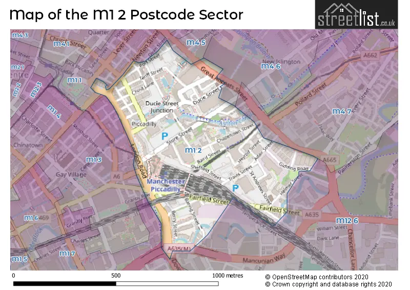
Map of the M1 2 Postcode Sector
Explore the M1 2 postcode sector by using our free interactive map.
| M | 1 | - | 2 | X | X |
| M | 1 | Space | 2 | Letter | Letter |
Official List of Streets
MANCHESTER (39 Streets)
Unofficial Streets or Alternative Spellings
MANCHESTER
ALTRINCHAM STREET AUBURN STREET BACK PICCADILLY BINNS PLACE CHATHAM STREET DOWNING STREET GORE STREET GRANBY ROW GREAT ANCOATS STREET HOYLE STREET JOHN SMEATON COURT LEVER STREET MANCUNIAN WAY NORTH WESTERN STREET PICCADILLY STATION PORTLAND STREET WHITWORTH STREET WILLIAM JESSOP COURT AQUADUCT STREET AQUEDUCT STREET BACK CHINA LANE BAIRD STREET BETLEY STREET BOAD STREET BROCK STREET BUXTON STREET CAVELL STREET COMET STREET CONGOU STREET CORONATION SQUARE COTSWOLD STREET DEAN STREET EPWORTH STREET FAIR STREET GIDDING ROAD GREAT STREET LEECH STREET FOOTBRIDGE LENA STREET LEYCROFT STREET LITTLE PITT STREET LIZARD STREET LOMAX STREET NEILD STREET NORTON STREET PARADISE WALK PEAK STREET RAVEN STREET ROCHDALE CANAL TOW PATH VANTAGE QUAY BRIDGE WHITTLES CROFT WYRE STREETWeather Forecast for M1 2
Press Button to Show Forecast for Ancoats
| Time Period | Icon | Description | Temperature | Rain Probability | Wind |
|---|---|---|---|---|---|
| 06:00 to 09:00 | Sunny day | 3.0°C (feels like 1.0°C) | 1.00% | NE 4 mph | |
| 09:00 to 12:00 | Partly cloudy (day) | 7.0°C (feels like 6.0°C) | 2.00% | ENE 4 mph | |
| 12:00 to 15:00 | Overcast | 9.0°C (feels like 8.0°C) | 9.00% | ENE 4 mph | |
| 15:00 to 18:00 | Cloudy | 10.0°C (feels like 9.0°C) | 6.00% | E 4 mph | |
| 18:00 to 21:00 | Cloudy | 9.0°C (feels like 8.0°C) | 6.00% | NE 4 mph | |
| 21:00 to 00:00 | Partly cloudy (night) | 6.0°C (feels like 4.0°C) | 4.00% | ENE 7 mph |
Press Button to Show Forecast for Ancoats
| Time Period | Icon | Description | Temperature | Rain Probability | Wind |
|---|---|---|---|---|---|
| 00:00 to 03:00 | Partly cloudy (night) | 4.0°C (feels like 2.0°C) | 6.00% | ENE 4 mph | |
| 03:00 to 06:00 | Partly cloudy (night) | 3.0°C (feels like 1.0°C) | 7.00% | ENE 4 mph | |
| 06:00 to 09:00 | Partly cloudy (day) | 4.0°C (feels like 2.0°C) | 6.00% | ENE 7 mph | |
| 09:00 to 12:00 | Partly cloudy (day) | 8.0°C (feels like 6.0°C) | 4.00% | E 7 mph | |
| 12:00 to 15:00 | Overcast | 10.0°C (feels like 8.0°C) | 16.00% | E 9 mph | |
| 15:00 to 18:00 | Light rain | 10.0°C (feels like 8.0°C) | 45.00% | E 9 mph | |
| 18:00 to 21:00 | Cloudy | 10.0°C (feels like 8.0°C) | 15.00% | ENE 9 mph | |
| 21:00 to 00:00 | Cloudy | 7.0°C (feels like 5.0°C) | 14.00% | NE 9 mph |
Press Button to Show Forecast for Ancoats
| Time Period | Icon | Description | Temperature | Rain Probability | Wind |
|---|---|---|---|---|---|
| 00:00 to 03:00 | Cloudy | 6.0°C (feels like 3.0°C) | 15.00% | NE 9 mph | |
| 03:00 to 06:00 | Cloudy | 6.0°C (feels like 3.0°C) | 16.00% | NE 9 mph | |
| 06:00 to 09:00 | Light rain | 7.0°C (feels like 4.0°C) | 49.00% | NE 9 mph | |
| 09:00 to 12:00 | Light rain | 8.0°C (feels like 5.0°C) | 50.00% | NNE 11 mph | |
| 12:00 to 15:00 | Heavy rain | 9.0°C (feels like 6.0°C) | 77.00% | NNE 11 mph | |
| 15:00 to 18:00 | Heavy rain | 10.0°C (feels like 7.0°C) | 76.00% | NNE 9 mph | |
| 18:00 to 21:00 | Light rain shower (day) | 10.0°C (feels like 8.0°C) | 38.00% | NNE 9 mph | |
| 21:00 to 00:00 | Clear night | 7.0°C (feels like 6.0°C) | 11.00% | NNW 7 mph |
House Prices in the M1 2 Postcode Sector
| Type of Property | 2018 Average | 2018 Sales | 2017 Average | 2017 Sales | 2016 Average | 2016 Sales | 2015 Average | 2015 Sales |
|---|---|---|---|---|---|---|---|---|
| Detached | £0 | 0 | £248,000 | 1 | £0 | 0 | £0 | 0 |
| Semi-Detached | £0 | 0 | £0 | 0 | £0 | 0 | £0 | 0 |
| Terraced | £215,000 | 1 | £0 | 0 | £340,000 | 1 | £320,000 | 1 |
| Flats | £207,871 | 72 | £216,466 | 74 | £185,490 | 100 | £179,996 | 113 |
Important Postcodes M1 2 in the Postcode Sector
M1 2BP is the postcode for British Transport Police, Tower Block, and Virgin Trains, Tower Block, Piccadilly Station
M1 2NP is the postcode for Unit 17, Piccadilly Trading Estate
M1 2PL is the postcode for Parcelforce Worldwide, Unit 12-18, Piccadilly Trading Estate
M1 2RP is the postcode for BRB (Residuary) Ltd, Piccadily Gate
M1 2WD is the postcode for BEIS, 3rd Floor, Piccadilly Gate, and DfE, Piccadilly Gate
M1 2WR is the postcode for 104-108, Fairfield Street
| The M1 2 Sector is within these Local Authorities |
|
|---|---|
| The M1 2 Sector is within these Counties |
|
| The M1 2 Sector is within these Water Company Areas |
|