The M19 1 postcode sector is within the county of Greater Manchester.
Did you know? According to the 2021 Census, the M19 1 postcode sector is home to a bustling 12,839 residents!
Given that each sector allows for 400 unique postcode combinations. Letters C, I, K, M, O and V are not allowed in the last two letters of a postcode. With 306 postcodes already in use, this leaves 94 units available.
The M19 1 postal code covers the settlement of MANCHESTER.
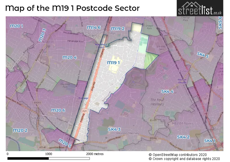
The M19 1 Postcode shares a border with SK4 4 (STOCKPORT), SK4 5 (STOCKPORT, Heaton Chapel), SK4 3 (STOCKPORT, Heaton Mersey), M14 6 (MANCHESTER, Fallowfield), M19 2 (MANCHESTER, Levenshulme, Burnage), M20 4 (MANCHESTER, Withington), M20 6 (MANCHESTER) and M20 5 (MANCHESTER).
The sector is within the post town of MANCHESTER.
M19 1 is a postcode sector within the M19 postcode district which is within the M Manchester postcode area.
The Royal Mail delivery office for the M19 1 postal sector is the Levenshulme Delivery Office.
The area of the M19 1 postcode sector is 0.81 square miles which is 2.11 square kilometres or 520.83 square acres.

Map of the M19 1 Postcode Sector
Explore the M19 1 postcode sector by using our free interactive map.
| M | 1 | 9 | - | 1 | X | X |
| M | 1 | 9 | Space | 1 | Letter | Letter |
Official List of Streets
MANCHESTER (137 Streets)
Burnage (2 Streets)
Unofficial Streets or Alternative Spellings
Heaton Chapel
CROSSLEY ROADMANCHESTER,
BARCICROFT ROAD MAULDETH ROADSTOCKPORT
ASHDENE ROAD BERWICK AVENUE BRASSINGTON ROAD DIDSBURY ROAD KENTSTONE AVENUE KINGSLEIGH ROAD MAIDSTONE ROADMANCHESTER
BURNSIDE DRIVE CROMPTON ROAD PARRS WOOD LANEGatley
KINGSWAY BARCICROFT ROAD WALK ERRWOOD ROAD CYCLEWAY HEATLEY CLOSE MILTON COURTWithington
MAULDETH ROADWeather Forecast for M19 1
Press Button to Show Forecast for Burnage
| Time Period | Icon | Description | Temperature | Rain Probability | Wind |
|---|---|---|---|---|---|
| 15:00 to 18:00 | Cloudy | 19.0°C (feels like 16.0°C) | 6.00% | SSE 16 mph | |
| 18:00 to 21:00 | Cloudy | 17.0°C (feels like 14.0°C) | 22.00% | SSE 13 mph | |
| 21:00 to 00:00 | Light rain | 15.0°C (feels like 14.0°C) | 52.00% | SE 11 mph |
Press Button to Show Forecast for Burnage
| Time Period | Icon | Description | Temperature | Rain Probability | Wind |
|---|---|---|---|---|---|
| 00:00 to 03:00 | Light rain | 15.0°C (feels like 13.0°C) | 40.00% | SE 9 mph | |
| 03:00 to 06:00 | Light rain | 15.0°C (feels like 13.0°C) | 49.00% | ESE 9 mph | |
| 06:00 to 09:00 | Heavy rain | 15.0°C (feels like 13.0°C) | 86.00% | ESE 9 mph | |
| 09:00 to 12:00 | Heavy rain | 15.0°C (feels like 14.0°C) | 88.00% | SE 7 mph | |
| 12:00 to 15:00 | Light rain | 15.0°C (feels like 14.0°C) | 61.00% | SE 9 mph | |
| 15:00 to 18:00 | Light rain | 16.0°C (feels like 14.0°C) | 41.00% | SE 11 mph | |
| 18:00 to 21:00 | Cloudy | 16.0°C (feels like 14.0°C) | 10.00% | SE 11 mph | |
| 21:00 to 00:00 | Cloudy | 14.0°C (feels like 12.0°C) | 6.00% | ESE 9 mph |
Press Button to Show Forecast for Burnage
| Time Period | Icon | Description | Temperature | Rain Probability | Wind |
|---|---|---|---|---|---|
| 00:00 to 03:00 | Cloudy | 13.0°C (feels like 12.0°C) | 5.00% | ESE 9 mph | |
| 03:00 to 06:00 | Cloudy | 12.0°C (feels like 11.0°C) | 5.00% | ESE 7 mph | |
| 06:00 to 09:00 | Partly cloudy (day) | 13.0°C (feels like 12.0°C) | 4.00% | E 7 mph | |
| 09:00 to 12:00 | Cloudy | 16.0°C (feels like 14.0°C) | 14.00% | ESE 9 mph | |
| 12:00 to 15:00 | Cloudy | 18.0°C (feels like 16.0°C) | 16.00% | ESE 9 mph | |
| 15:00 to 18:00 | Light rain shower (day) | 18.0°C (feels like 16.0°C) | 36.00% | ESE 9 mph | |
| 18:00 to 21:00 | Cloudy | 17.0°C (feels like 16.0°C) | 14.00% | ESE 7 mph | |
| 21:00 to 00:00 | Clear night | 14.0°C (feels like 13.0°C) | 3.00% | E 4 mph |
Press Button to Show Forecast for Burnage
| Time Period | Icon | Description | Temperature | Rain Probability | Wind |
|---|---|---|---|---|---|
| 00:00 to 03:00 | Clear night | 12.0°C (feels like 11.0°C) | 1.00% | E 4 mph | |
| 03:00 to 06:00 | Clear night | 10.0°C (feels like 10.0°C) | 2.00% | E 4 mph | |
| 06:00 to 09:00 | Sunny day | 12.0°C (feels like 12.0°C) | 2.00% | E 4 mph | |
| 09:00 to 12:00 | Partly cloudy (day) | 17.0°C (feels like 17.0°C) | 5.00% | WNW 4 mph | |
| 12:00 to 15:00 | Partly cloudy (day) | 19.0°C (feels like 18.0°C) | 10.00% | WSW 4 mph | |
| 15:00 to 18:00 | Cloudy | 19.0°C (feels like 18.0°C) | 15.00% | W 7 mph | |
| 18:00 to 21:00 | Light rain shower (day) | 17.0°C (feels like 17.0°C) | 34.00% | W 7 mph | |
| 21:00 to 00:00 | Light rain shower (night) | 15.0°C (feels like 14.0°C) | 34.00% | NW 7 mph |
Press Button to Show Forecast for Burnage
| Time Period | Icon | Description | Temperature | Rain Probability | Wind |
|---|---|---|---|---|---|
| 00:00 to 03:00 | Partly cloudy (night) | 13.0°C (feels like 12.0°C) | 5.00% | NW 7 mph | |
| 03:00 to 06:00 | Partly cloudy (night) | 12.0°C (feels like 11.0°C) | 3.00% | NNW 4 mph | |
| 06:00 to 09:00 | Partly cloudy (day) | 13.0°C (feels like 12.0°C) | 5.00% | N 4 mph | |
| 09:00 to 12:00 | Cloudy | 16.0°C (feels like 15.0°C) | 8.00% | NNE 7 mph | |
| 12:00 to 15:00 | Partly cloudy (day) | 18.0°C (feels like 17.0°C) | 10.00% | NNE 7 mph | |
| 15:00 to 18:00 | Light rain shower (day) | 18.0°C (feels like 17.0°C) | 32.00% | NNW 9 mph | |
| 18:00 to 21:00 | Light rain shower (day) | 17.0°C (feels like 15.0°C) | 30.00% | N 9 mph | |
| 21:00 to 00:00 | Partly cloudy (night) | 13.0°C (feels like 12.0°C) | 8.00% | N 9 mph |
Schools and Places of Education Within the M19 1 Postcode Sector
Burnage Academy for Boys
Academy converter
Burnage Lane, Manchester, , M19 1ER
Head: Mr Karl Harrison
Ofsted Rating: Outstanding
Inspection: 2018-10-03 (2049 days ago)
Website: Visit Burnage Academy for Boys Website
Phone: 01614321527
Number of Pupils: 947
Green End Primary School
Academy converter
Burnage Lane, Manchester, , M19 1DR
Head: Mrs Lisa Vyas
Ofsted Rating: Outstanding
Inspection: 2015-07-15 (3225 days ago)
Website: Visit Green End Primary School Website
Phone: 01614327036
Number of Pupils: 483
Levenshulme High School
Academy sponsor led
Crossley Road, Manchester, Greater Manchester, M19 1FS
Head: Neil Johnson, Donna Johnson (joint)
Ofsted Rating: Outstanding
Inspection: 2022-06-09 (704 days ago)
Website: Visit Levenshulme High School Website
Phone: 01612244625
Number of Pupils: 1008
St Bernard's RC Primary School Manchester
Voluntary aided school
Burnage Lane, Manchester, , M19 1DR
Head: Mrs Claire Breeze
Ofsted Rating: Good
Inspection: 2022-12-08 (522 days ago)
Website: Visit St Bernard's RC Primary School Manchester Website
Phone: 01614327635
Number of Pupils: 213
House Prices in the M19 1 Postcode Sector
| Type of Property | 2018 Average | 2018 Sales | 2017 Average | 2017 Sales | 2016 Average | 2016 Sales | 2015 Average | 2015 Sales |
|---|---|---|---|---|---|---|---|---|
| Detached | £345,000 | 2 | £229,500 | 1 | £122,000 | 1 | £224,250 | 4 |
| Semi-Detached | £220,264 | 122 | £196,872 | 89 | £182,490 | 76 | £167,139 | 68 |
| Terraced | £174,915 | 26 | £164,512 | 25 | £161,085 | 23 | £137,197 | 30 |
| Flats | £158,419 | 13 | £117,646 | 8 | £134,113 | 26 | £124,677 | 19 |
Important Postcodes M19 1 in the Postcode Sector
M19 1DR is the postcode for Green End Academy, Burnage Lane, MAIN BUILDING, St. Bernards Primary School, Burnage Lane, SPORTS HALL, Green End Academy, Burnage Lane, MAIN SCHOOL BUILDING, Green End Academy, Burnage Lane, St. Bernards Primary School, Burnage Lane, and NURSERY BLOCK, St. Bernards Primary School, Burnage Lane
M19 1ER is the postcode for MAIN SCHOOL, Burnage Media Arts College, Burnage Lane, SPORTS HALL, Burnage Media Arts College, Burnage Lane, SPORTS HALL, Burnage Academy for Boys, Burnage Lane, and Burnage Academy for Boys, Burnage Lane
M19 1EW is the postcode for Burnage Health Care Centre, 347 Burnage Lane
M19 1FS is the postcode for ENERGY BOX, Levenshulme High School, Crossley Road, ACACIAS COMMUNITY PRIMARY SCHOOL, Levenshulme High School and Acacias Community Primary School, Levenshulme High School, CROSSLEY, Levenshulme High School, Crossley Road, ERRWOOD, Levenshulme High School, Crossley Road, CROSSLEY, Levenshulme High School and Acacias Community Primary School, Levenshulme High School, and Levenshulme High School, Crossley Road
| The M19 1 Sector is within these Local Authorities |
|
|---|---|
| The M19 1 Sector is within these Counties |
|
| The M19 1 Sector is within these Water Company Areas |
|