The M27 9 postcode sector is within the county of Greater Manchester.
Did you know? According to the 2021 Census, the M27 9 postcode sector is home to a bustling 6,311 residents!
Given that each sector allows for 400 unique postcode combinations. Letters C, I, K, M, O and V are not allowed in the last two letters of a postcode. With 150 postcodes already in use, this leaves 250 units available.
The M27 9 postal code covers the settlement of Swinton.
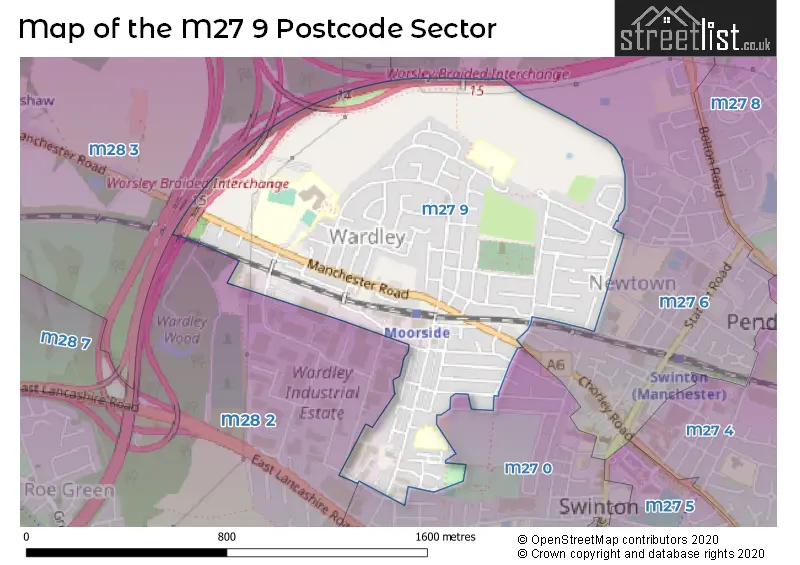
The M27 9 Postcode shares a border with M27 0 (Swinton), M27 6 (Swinton), M28 2 (Worsley) and M28 3 (Worsley).
The sector is within the post town of MANCHESTER.
M27 9 is a postcode sector within the M27 postcode district which is within the M Manchester postcode area.
The Royal Mail delivery office for the M27 9 postal sector is the North West (m) Delivery Office.
The area of the M27 9 postcode sector is 0.63 square miles which is 1.64 square kilometres or 405.33 square acres.
The M27 9 postcode sector is crossed by the M60 motorway.

Map of the M27 9 Postcode Sector
Explore the M27 9 postcode sector by using our free interactive map.
| M | 2 | 7 | - | 9 | X | X |
| M | 2 | 7 | Space | 9 | Letter | Letter |
Official List of Streets
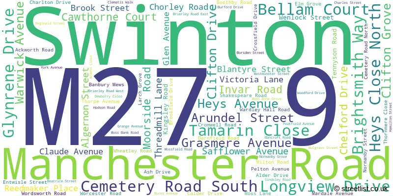
Swinton (84 Streets)
Unofficial Streets or Alternative Spellings
Weather Forecast for M27 9
Press Button to Show Forecast for Wardley
| Time Period | Icon | Description | Temperature | Rain Probability | Wind |
|---|---|---|---|---|---|
| 06:00 to 09:00 | Sunny day | 3.0°C (feels like 1.0°C) | 1.00% | NE 4 mph | |
| 09:00 to 12:00 | Cloudy | 7.0°C (feels like 5.0°C) | 4.00% | ENE 4 mph | |
| 12:00 to 15:00 | Overcast | 9.0°C (feels like 8.0°C) | 9.00% | E 4 mph | |
| 15:00 to 18:00 | Cloudy | 10.0°C (feels like 9.0°C) | 6.00% | ENE 4 mph | |
| 18:00 to 21:00 | Cloudy | 9.0°C (feels like 8.0°C) | 6.00% | NE 4 mph | |
| 21:00 to 00:00 | Partly cloudy (night) | 6.0°C (feels like 4.0°C) | 4.00% | ENE 7 mph |
Press Button to Show Forecast for Wardley
| Time Period | Icon | Description | Temperature | Rain Probability | Wind |
|---|---|---|---|---|---|
| 00:00 to 03:00 | Partly cloudy (night) | 4.0°C (feels like 2.0°C) | 5.00% | ENE 4 mph | |
| 03:00 to 06:00 | Clear night | 3.0°C (feels like 1.0°C) | 5.00% | ENE 4 mph | |
| 06:00 to 09:00 | Partly cloudy (day) | 4.0°C (feels like 2.0°C) | 5.00% | ENE 7 mph | |
| 09:00 to 12:00 | Partly cloudy (day) | 8.0°C (feels like 6.0°C) | 5.00% | E 7 mph | |
| 12:00 to 15:00 | Overcast | 10.0°C (feels like 8.0°C) | 14.00% | E 7 mph | |
| 15:00 to 18:00 | Cloudy | 10.0°C (feels like 8.0°C) | 17.00% | E 9 mph | |
| 18:00 to 21:00 | Cloudy | 9.0°C (feels like 7.0°C) | 15.00% | ENE 9 mph | |
| 21:00 to 00:00 | Cloudy | 7.0°C (feels like 4.0°C) | 15.00% | ENE 9 mph |
Press Button to Show Forecast for Wardley
| Time Period | Icon | Description | Temperature | Rain Probability | Wind |
|---|---|---|---|---|---|
| 00:00 to 03:00 | Cloudy | 6.0°C (feels like 3.0°C) | 13.00% | NE 9 mph | |
| 03:00 to 06:00 | Cloudy | 6.0°C (feels like 3.0°C) | 19.00% | NE 9 mph | |
| 06:00 to 09:00 | Light rain | 7.0°C (feels like 4.0°C) | 48.00% | NE 9 mph | |
| 09:00 to 12:00 | Light rain | 8.0°C (feels like 5.0°C) | 49.00% | NNE 11 mph | |
| 12:00 to 15:00 | Heavy rain | 9.0°C (feels like 6.0°C) | 78.00% | NNE 11 mph | |
| 15:00 to 18:00 | Heavy rain | 9.0°C (feels like 7.0°C) | 77.00% | N 9 mph | |
| 18:00 to 21:00 | Light rain shower (day) | 10.0°C (feels like 8.0°C) | 39.00% | NNW 9 mph | |
| 21:00 to 00:00 | Partly cloudy (night) | 8.0°C (feels like 6.0°C) | 12.00% | NNW 7 mph |
Schools and Places of Education Within the M27 9 Postcode Sector
St Ambrose Barlow RC High School
Voluntary aided school
37 Ash Drive, Manchester, , M27 9QP
Head: Mr Ben Davis
Ofsted Rating: Requires improvement
Inspection: 2022-03-10 (778 days ago)
Website: Visit St Ambrose Barlow RC High School Website
Phone: 01619211570
Number of Pupils: 1082
St Charles' RC Primary School
Voluntary aided school
Emlyn Street, Manchester, , M27 9PD
Head: Mrs Nicola Drake
Ofsted Rating: Good
Inspection: 2019-01-16 (1927 days ago)
Website: Visit St Charles' RC Primary School Website
Phone: 01619211945
Number of Pupils: 225
Wardley CofE Primary School
Voluntary controlled school
Moss Bank Road, Manchester, , M27 9XB
Head: Mr Mark Foster
Ofsted Rating: Outstanding
Inspection: 2017-06-28 (2494 days ago)
Website: Visit Wardley CofE Primary School Website
Phone: 01619211098
Number of Pupils: 232
House Prices in the M27 9 Postcode Sector
| Type of Property | 2018 Average | 2018 Sales | 2017 Average | 2017 Sales | 2016 Average | 2016 Sales | 2015 Average | 2015 Sales |
|---|---|---|---|---|---|---|---|---|
| Detached | £180,143 | 7 | £169,600 | 5 | £200,400 | 5 | £167,786 | 7 |
| Semi-Detached | £156,513 | 47 | £143,897 | 41 | £134,600 | 44 | £125,873 | 43 |
| Terraced | £126,239 | 60 | £112,354 | 53 | £115,054 | 42 | £98,341 | 37 |
| Flats | £95,125 | 8 | £91,418 | 11 | £90,500 | 6 | £82,929 | 7 |
Important Postcodes M27 9 in the Postcode Sector
M27 9PD is the postcode for St. Charles RC Primary School, Moorside Road, Swinton, and St. Charles RC Primary School, Moorside Road
M27 9QP is the postcode for St. Ambrose Barlow RC High School, 37 Ash Drive, Wardley, Swinton, and St. Ambrose Barlow RC High School, 37 Ash Drive
M27 9SZ is the postcode for Swinton and Pendlebury Leisure Centre, Cromwell Road, Swinton, and Swinton and Pendlebury Leisure Centre, Cromwell Road
M27 9XB is the postcode for Wardley C of E School, Moss Bank Road, Wardley, Swinton, and Wardley C of E School, Moss Bank Road
| The M27 9 Sector is within these Local Authorities |
|
|---|---|
| The M27 9 Sector is within these Counties |
|
| The M27 9 Sector is within these Water Company Areas |
|