The M31 postcode district is a postal district located in the M Manchester postcode area with a population of 8,176 residents according to the 2021 England and Wales Census.
The area of the M31 postcode district is 4.19 square miles which is 10.86 square kilometres or 2,682.49 acres.
Currently, the M31 district has about 247 postcode units spread across 1 geographic postcode sectors.
Given that each sector allows for 400 unique postcode combinations, the district has a capacity of 400 postcodes. With 247 postcodes already in use, this leaves 153 units available.
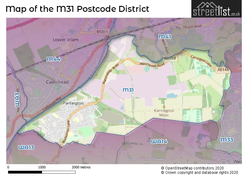
The largest settlements in the M31 postal code are Partington and Carrington.
The M31 Postcode shares a border with WA13 (LYMM, Warburton), WA14 (ALTRINCHAM, Bowdon, Broadheath), M44 (Irlam, Cadishead), M33 (SALE) and M41 (Urmston).
The primary settlement in the M31 postcode district is Partington, which is located in the county of Greater Manchester in England. The most significant postal town in this district is Manchester. Other significant settlements within the M31 postcode district are Carrington.
For the district M31, we have data on 1 postcode sectors. Here's a breakdown: The sector M31 4, covers Partington and Carrington in Greater Manchester.
M31 Postcode Sectors

Map of the M31 Postcode District
Explore the M31 postcode district by using our free interactive map.
When it comes to local government, postal geography often disregards political borders. However, for a breakdown in the M31 District: the district mostly encompasses the Trafford District (B) area with a total of 265 postcodes.
Recent House Sales in M31
| Date | Price | Address |
|---|---|---|
| 25/09/2023 | £289,890 | Lock Lane, Partington, Manchester, M31 4PP |
| 25/08/2023 | £185,000 | Snowberry Walk, Partington, Manchester, M31 4NB |
| 11/08/2023 | £217,000 | Warburton Lane, Partington, Manchester, M31 4NL |
| 08/08/2023 | £110,000 | Northumberland Road, Partington, Manchester, M31 4NN |
| 07/08/2023 | £260,000 | Thirlmere Road, Partington, Manchester, M31 4PT |
| 21/07/2023 | £280,000 | Manchester Road, Carrington, Manchester, M31 4BD |
| 18/07/2023 | £130,000 | Hardwick Road, Partington, Manchester, M31 4DQ |
| 26/06/2023 | £195,000 | Lyle Terrace, Partington, Manchester, M31 4BU |
| 14/06/2023 | £162,500 | Columbine Walk, Partington, Manchester, M31 4FG |
| 07/06/2023 | £185,000 | Columbine Walk, Partington, Manchester, M31 4FG |
Weather Forecast for M31
Press Button to Show Forecast for Partington
| Time Period | Icon | Description | Temperature | Rain Probability | Wind |
|---|---|---|---|---|---|
| 03:00 to 06:00 | Partly cloudy (night) | 5.0°C (feels like 3.0°C) | 3.00% | NE 7 mph | |
| 06:00 to 09:00 | Cloudy | 5.0°C (feels like 3.0°C) | 5.00% | NE 7 mph | |
| 09:00 to 12:00 | Cloudy | 8.0°C (feels like 6.0°C) | 5.00% | ENE 9 mph | |
| 12:00 to 15:00 | Cloudy | 10.0°C (feels like 8.0°C) | 14.00% | ENE 9 mph | |
| 15:00 to 18:00 | Cloudy | 10.0°C (feels like 8.0°C) | 48.00% | E 9 mph | |
| 18:00 to 21:00 | Cloudy | 9.0°C (feels like 7.0°C) | 13.00% | ENE 9 mph | |
| 21:00 to 00:00 | Cloudy | 8.0°C (feels like 5.0°C) | 5.00% | NE 7 mph |
Press Button to Show Forecast for Partington
| Time Period | Icon | Description | Temperature | Rain Probability | Wind |
|---|---|---|---|---|---|
| 00:00 to 03:00 | Cloudy | 6.0°C (feels like 4.0°C) | 4.00% | NNE 7 mph | |
| 03:00 to 06:00 | Cloudy | 6.0°C (feels like 3.0°C) | 6.00% | N 7 mph | |
| 06:00 to 09:00 | Cloudy | 6.0°C (feels like 4.0°C) | 12.00% | N 7 mph | |
| 09:00 to 12:00 | Cloudy | 8.0°C (feels like 5.0°C) | 15.00% | NNW 9 mph | |
| 12:00 to 15:00 | Cloudy | 10.0°C (feels like 8.0°C) | 14.00% | NW 9 mph | |
| 15:00 to 18:00 | Cloudy | 11.0°C (feels like 8.0°C) | 10.00% | WNW 11 mph | |
| 18:00 to 21:00 | Sunny day | 10.0°C (feels like 8.0°C) | 4.00% | W 9 mph | |
| 21:00 to 00:00 | Clear night | 8.0°C (feels like 6.0°C) | 1.00% | WSW 7 mph |
Press Button to Show Forecast for Partington
| Time Period | Icon | Description | Temperature | Rain Probability | Wind |
|---|---|---|---|---|---|
| 00:00 to 03:00 | Clear night | 6.0°C (feels like 4.0°C) | 1.00% | SSW 7 mph | |
| 03:00 to 06:00 | Partly cloudy (night) | 5.0°C (feels like 2.0°C) | 1.00% | SSE 7 mph | |
| 06:00 to 09:00 | Cloudy | 6.0°C (feels like 3.0°C) | 5.00% | SSE 9 mph | |
| 09:00 to 12:00 | Partly cloudy (day) | 10.0°C (feels like 8.0°C) | 2.00% | S 11 mph | |
| 12:00 to 15:00 | Cloudy | 13.0°C (feels like 10.0°C) | 7.00% | S 16 mph | |
| 15:00 to 18:00 | Cloudy | 14.0°C (feels like 11.0°C) | 10.00% | S 13 mph | |
| 18:00 to 21:00 | Partly cloudy (day) | 13.0°C (feels like 11.0°C) | 6.00% | S 11 mph | |
| 21:00 to 00:00 | Clear night | 10.0°C (feels like 8.0°C) | 3.00% | SSE 11 mph |
Press Button to Show Forecast for Partington
| Time Period | Icon | Description | Temperature | Rain Probability | Wind |
|---|---|---|---|---|---|
| 00:00 to 03:00 | Clear night | 9.0°C (feels like 7.0°C) | 4.00% | SE 9 mph | |
| 03:00 to 06:00 | Partly cloudy (night) | 8.0°C (feels like 6.0°C) | 3.00% | SE 9 mph | |
| 06:00 to 09:00 | Sunny day | 9.0°C (feels like 7.0°C) | 3.00% | ESE 9 mph | |
| 09:00 to 12:00 | Partly cloudy (day) | 13.0°C (feels like 10.0°C) | 4.00% | ESE 13 mph | |
| 12:00 to 15:00 | Partly cloudy (day) | 15.0°C (feels like 12.0°C) | 8.00% | SE 13 mph | |
| 15:00 to 18:00 | Partly cloudy (day) | 16.0°C (feels like 14.0°C) | 10.00% | SE 13 mph | |
| 18:00 to 21:00 | Partly cloudy (day) | 15.0°C (feels like 13.0°C) | 7.00% | ESE 9 mph | |
| 21:00 to 00:00 | Cloudy | 13.0°C (feels like 11.0°C) | 7.00% | ESE 9 mph |
Where is the M31 Postcode District?
The postcode district M31 is located in Manchester. It is situated in close proximity to several nearby towns, including Altrincham, Sale, Lymm, Salford, Leigh, Warrington, and Knutsford. The district is approximately 163.54 miles away from the center of London.
The district is within the post town of MANCHESTER.
The sector has postcodes within the nation of England.
The M31 Postcode District is in the Greater Manchester South West region of Greater Manchester within the North West (England).
Postcode Sectors within the M31 District
| Postcode Sector | Delivery Office |
|---|---|
| M31 4 | Urmston Delivery Office |
| M | 3 | 1 | - | X | X | X |
| M | 3 | 1 | Space | Numeric | Letter | Letter |
Current Monthly Rental Prices
| # Bedrooms | Min Price | Max Price | Avg Price |
|---|---|---|---|
| 3 | £1,100 | £1,100 | £1,100 |
Current House Prices
| # Bedrooms | Min Price | Max Price | Avg Price |
|---|---|---|---|
| 1 | £80,000 | £80,000 | £80,000 |
| 2 | £119,950 | £215,000 | £181,990 |
| 3 | £142,498 | £325,000 | £233,741 |
| 4 | £230,000 | £399,995 | £364,854 |
| 6 | £950,000 | £950,000 | £950,000 |
Estate Agents who Operate in the M31 District
| Logo | Name | Brand Name | Address | Contact Number | Total Properties |
|---|---|---|---|---|---|
 | Urmston | Trading Places | 42 Flixton Road, Urmston, M41 5AB | 0161 524 7763 | 10 |
 | covering Manchester | Purplebricks | Suite 7 First Floor Cranmore Drive Shirley Solihull B90 4RZ | 0161 524 9265 | 4 |
 | Urmston | Paul Birtles Estate Agents | 3 Flixton Road, Urmston, M41 5AW, | 0161 524 3341 | 3 |
 | Urmston | Home Estate Agents | 1 Crofts Bank Road Urmston M41 0TZ | 0161 524 5837 | 3 |
 | Urmston | VitalSpace | 22 Flixton Road Urmston M41 5AA | 0161 524 3442 | 2 |
| Type of Property | 2018 Average | 2018 Sales | 2017 Average | 2017 Sales | 2016 Average | 2016 Sales | 2015 Average | 2015 Sales |
|---|---|---|---|---|---|---|---|---|
| Detached | £312,500 | 2 | £175,000 | 1 | £226,200 | 7 | £215,556 | 9 |
| Semi-Detached | £166,378 | 46 | £147,286 | 33 | £131,468 | 32 | £124,861 | 27 |
| Terraced | £135,790 | 36 | £130,331 | 46 | £111,462 | 45 | £95,704 | 38 |
| Flats | £68,950 | 1 | £77,500 | 2 | £0 | 0 | £43,025 | 2 |