The M50 postcode district is a postal district located in the M Manchester postcode area with a population of 6,379 residents according to the 2021 England and Wales Census.
The area of the M50 postcode district is 1.00 square miles which is 2.59 square kilometres or 640.92 acres.
Currently, the M50 district has about 189 postcode units spread across 3 geographic postcode sectors.
Given that each sector allows for 400 unique postcode combinations, the district has a capacity of 1,200 postcodes. With 189 postcodes already in use, this leaves 1011 units available.
The largest settlements in the M50 postal code are SALFORD and Media City UK.
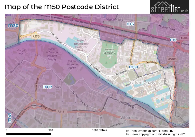
The M50 Postcode shares a border with M5 (SALFORD) and M17 (Trafford Park, The Trafford Centre, MANCHESTER).
The primary settlement in the M50 postcode district is Salford, located in Greater Manchester. Other significant settlements in the district include Media City UK. The most significant post town in this postcode district is Salford.
For the district M50, we have data on 3 postcode sectors. Here's a breakdown: The sector M50 1, covers Salford in Greater Manchester. The sector M50 2, covers Salford and Media City Uk in Greater Manchester. The sector M50 3, covers Salford in Greater Manchester.


Map of the M50 Postcode District
Explore the M50 postcode district by using our free interactive map.
When it comes to local government, postal geography often disregards political borders. However, for a breakdown in the M50 District: the district mostly encompasses the Salford District (B) area with a total of 193 postcodes.
Recent House Sales in M50
| Date | Price | Address |
|---|---|---|
| 16/10/2023 | £199,500 | Blue, Media City Uk, Salford, M50 2AF |
| 10/10/2023 | £183,000 | Blue, Media City Uk, Salford, M50 2AD |
| 09/10/2023 | £180,000 | Pink, Media City Uk, Salford, M50 2BB |
| 22/09/2023 | £125,000 | Blue, Media City Uk, Salford, M50 2TH |
| 13/09/2023 | £134,000 | Pilgrims Way, Salford, M50 1AZ |
| 04/09/2023 | £115,000 | Michigan Avenue, Salford, M50 2HB |
| 04/09/2023 | £110,000 | Pink, Media City Uk, Salford, M50 2BA |
| 01/09/2023 | £140,000 | Pilgrims Way, Salford, M50 1AU |
| 04/08/2023 | £430,000 | The Quays, Salford, M50 3SB |
| 31/07/2023 | £762,000 | Missouri Avenue, Salford, M50 2NP |
Where is the M50 Postcode District?
The postcode district "M50" is located in the town of Salford. Salford is nearby several towns including Manchester, Sale, Altrincham, Heywood, Bolton, and Dukinfield. The distance between Salford and London is approximately 164.12 miles.
The district is within the post town of SALFORD.
The sector has postcodes within the nation of England.
The M50 Postcode District is in the Greater Manchester South West region of Greater Manchester within the North West (England).
Weather Forecast for M50
Press Button to Show Forecast for Salford
| Time Period | Icon | Description | Temperature | Rain Probability | Wind |
|---|---|---|---|---|---|
| 03:00 to 06:00 | Light rain | 11.0°C (feels like 10.0°C) | 45.00% | SW 4 mph | |
| 06:00 to 09:00 | Cloudy | 10.0°C (feels like 9.0°C) | 15.00% | SSW 4 mph | |
| 09:00 to 12:00 | Cloudy | 12.0°C (feels like 11.0°C) | 9.00% | SSW 7 mph | |
| 12:00 to 15:00 | Cloudy | 14.0°C (feels like 13.0°C) | 10.00% | SSW 7 mph | |
| 15:00 to 18:00 | Cloudy | 16.0°C (feels like 14.0°C) | 11.00% | SW 7 mph | |
| 18:00 to 21:00 | Cloudy | 15.0°C (feels like 14.0°C) | 11.00% | SSW 7 mph | |
| 21:00 to 00:00 | Cloudy | 13.0°C (feels like 12.0°C) | 8.00% | WSW 7 mph |
Press Button to Show Forecast for Salford
| Time Period | Icon | Description | Temperature | Rain Probability | Wind |
|---|---|---|---|---|---|
| 00:00 to 03:00 | Partly cloudy (night) | 12.0°C (feels like 11.0°C) | 5.00% | W 7 mph | |
| 03:00 to 06:00 | Cloudy | 11.0°C (feels like 10.0°C) | 10.00% | E 4 mph | |
| 06:00 to 09:00 | Partly cloudy (day) | 11.0°C (feels like 10.0°C) | 7.00% | ENE 7 mph | |
| 09:00 to 12:00 | Cloudy | 13.0°C (feels like 12.0°C) | 9.00% | SSE 7 mph | |
| 12:00 to 15:00 | Cloudy | 16.0°C (feels like 14.0°C) | 11.00% | S 9 mph | |
| 15:00 to 18:00 | Cloudy | 17.0°C (feels like 15.0°C) | 18.00% | SSE 7 mph | |
| 18:00 to 21:00 | Cloudy | 16.0°C (feels like 14.0°C) | 16.00% | SW 7 mph | |
| 21:00 to 00:00 | Partly cloudy (night) | 14.0°C (feels like 13.0°C) | 8.00% | NNE 7 mph |
| Postcode Sector | Delivery Office |
|---|---|
| M50 1 | Salford Delivery Office |
| M50 2 | Salford Delivery Office |
| M50 3 | Salford Delivery Office |
| M50 4 | Salford Delivery Office |
| M50 5 | Salford Delivery Office |
| M50 6 | Salford Delivery Office |
| M50 7 | Salford Delivery Office |
| M50 8 | Salford Delivery Office |
| M50 9 | Salford Delivery Office |
| M | 5 | 0 | - | X | X | X |
| M | 5 | 0 | Space | Numeric | Letter | Letter |
Current Monthly Rental Prices
| # Bedrooms | Min Price | Max Price | Avg Price |
|---|
Current House Prices
| # Bedrooms | Min Price | Max Price | Avg Price |
|---|
Estate Agents who Operate in the M50 District
| Logo | Name | Brand Name | Address | Contact Number | Total Properties |
|---|
Yearly House Price Averages for the M50 Postcode District
| Type of Property | 2018 Average | 2018 Sales | 2017 Average | 2017 Sales | 2016 Average | 2016 Sales | 2015 Average | 2015 Sales |
|---|---|---|---|---|---|---|---|---|
| Detached | £0 | 0 | £297,167 | 3 | £0 | 0 | £97,000 | 1 |
| Semi-Detached | £375,000 | 2 | £0 | 0 | £109,225 | 2 | £249,950 | 1 |
| Terraced | £252,692 | 6 | £199,480 | 7 | £297,992 | 6 | £203,583 | 6 |
| Flats | £182,014 | 285 | £166,558 | 765 | £172,610 | 415 | £126,086 | 344 |