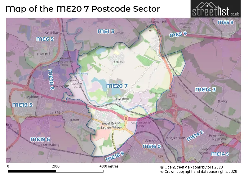
The ME20 7 postcode sector is within the county of Kent.
Did you know? According to the 2021 Census, the ME20 7 postcode sector is home to a bustling 8,304 residents!
Given that each sector allows for 400 unique postcode combinations. Letters C, I, K, M, O and V are not allowed in the last two letters of a postcode. With 242 postcodes already in use, this leaves 158 units available.
The largest settlement in the ME20 7 postal code is AYLESFORD followed by Eccles, and Larkfield.
The ME20 7 Postcode shares a border with ME1 3 (ROCHESTER, Wouldham, Burham), ME5 9 (CHATHAM, Walderslade, Blue Bell Hill), ME14 3 (Detling, Sandling, Boxley), ME16 0 (MAIDSTONE, Allington), ME16 9 (MAIDSTONE, Barming, Allington), ME19 6 (East Malling, WEST MALLING) and ME20 6 (Larkfield, Ditton).
The sector is within the post town of AYLESFORD.
ME20 7 is a postcode sector within the ME2 postcode district which is within the ME Medway postcode area.
The Royal Mail delivery office for the ME20 7 postal sector is the unknown.
The area of the ME20 7 postcode sector is 5.67 square miles which is 14.69 square kilometres or 3,628.80 square acres.
The ME20 7 postcode sector is crossed by the M20 motorway.
Waterways within the ME20 7 postcode sector include the River Medway.

Map of the ME20 7 Postcode Sector
Explore the ME20 7 postcode sector by using our free interactive map.
| M | E | 2 | 0 | - | 7 | X | X |
| M | E | 2 | 0 | Space | 7 | Letter | Letter |
Official List of Streets
Larkfield (5 Streets)
Royal British Legion Village (7 Streets)
Eccles (20 Streets)
AYLESFORD (79 Streets)
Panattoni Park (3 Streets)
Quarry Wood (5 Streets)
Blue Bell Hill (3 Streets)
Unofficial Streets or Alternative Spellings
Boxley
PILGRIMS WAYAYLESFORD,
HERMITAGE LANEBlue Bell Hill
WARREN ROADSandling
FORSTAL ROADDitton
BELL LANE GORSE CRESCENT STATION ROAD WOODLANDS ROADLarkfield
BELLINGHAM WAY PAPYRUS WAY AYLESFORD INTERCHANGE BURNTASH ROAD CENTRAL ROAD CHURCH WALK CLARK MEWS DRY END ROAD FORSTAL COTTAGES MILL HALL ROAD MILLHALL PERIMETER ROAD ROSARY WALK ST LAURENCE AVENUE STINGY FLY ALLEY WEALDEN WAY WESTMEADBurham
PILGRIMS WAYAddington
LONDON ROADWeather Forecast for ME20 7
Press Button to Show Forecast for East Malling
| Time Period | Icon | Description | Temperature | Rain Probability | Wind |
|---|---|---|---|---|---|
| 21:00 to 00:00 | Clear night | 11.0°C (feels like 9.0°C) | 2.00% | SW 7 mph |
Press Button to Show Forecast for East Malling
| Time Period | Icon | Description | Temperature | Rain Probability | Wind |
|---|---|---|---|---|---|
| 00:00 to 03:00 | Clear night | 9.0°C (feels like 8.0°C) | 1.00% | SW 7 mph | |
| 03:00 to 06:00 | Clear night | 8.0°C (feels like 6.0°C) | 1.00% | SSW 4 mph | |
| 06:00 to 09:00 | Sunny day | 9.0°C (feels like 8.0°C) | 4.00% | SSW 4 mph | |
| 09:00 to 12:00 | Partly cloudy (day) | 13.0°C (feels like 12.0°C) | 8.00% | S 9 mph | |
| 12:00 to 15:00 | Partly cloudy (day) | 16.0°C (feels like 13.0°C) | 11.00% | S 11 mph | |
| 15:00 to 18:00 | Cloudy | 16.0°C (feels like 14.0°C) | 14.00% | S 9 mph | |
| 18:00 to 21:00 | Sunny day | 14.0°C (feels like 13.0°C) | 11.00% | S 9 mph | |
| 21:00 to 00:00 | Cloudy | 11.0°C (feels like 10.0°C) | 15.00% | SSE 4 mph |
Press Button to Show Forecast for East Malling
| Time Period | Icon | Description | Temperature | Rain Probability | Wind |
|---|---|---|---|---|---|
| 00:00 to 03:00 | Partly cloudy (night) | 10.0°C (feels like 9.0°C) | 14.00% | SSW 4 mph | |
| 03:00 to 06:00 | Partly cloudy (night) | 9.0°C (feels like 8.0°C) | 10.00% | SSW 4 mph | |
| 06:00 to 09:00 | Cloudy | 11.0°C (feels like 9.0°C) | 14.00% | SSW 4 mph | |
| 09:00 to 12:00 | Cloudy | 14.0°C (feels like 12.0°C) | 14.00% | SSW 9 mph | |
| 12:00 to 15:00 | Cloudy | 16.0°C (feels like 14.0°C) | 14.00% | SSW 11 mph | |
| 15:00 to 18:00 | Cloudy | 16.0°C (feels like 14.0°C) | 18.00% | S 9 mph | |
| 18:00 to 21:00 | Partly cloudy (day) | 15.0°C (feels like 14.0°C) | 10.00% | S 7 mph | |
| 21:00 to 00:00 | Cloudy | 12.0°C (feels like 11.0°C) | 12.00% | S 4 mph |
Schools and Places of Education Within the ME20 7 Postcode Sector
St Mark's Church of England Primary School, Eccles
Academy converter
Eccles Row, Aylesford, Kent, ME20 7HS
Head: Mr Jonathan Bassett
Ofsted Rating: Good
Inspection: 2022-03-22 (773 days ago)
Website: Visit St Mark's Church of England Primary School, Eccles Website
Phone: 01622717337
Number of Pupils: 128
St Peter's Church of England Primary School
Voluntary controlled school
Mount Pleasant, Aylesford, Kent, ME20 7BE
Head: Mr Jim Holditch
Ofsted Rating: Good
Inspection: 2019-03-20 (1871 days ago)
Website: Visit St Peter's Church of England Primary School Website
Phone: 01622717335
Number of Pupils: 194
Valley Invicta Primary School At Aylesford
Academy sponsor led
Teapot Lane, Aylesford, Kent, ME20 7JU
Head: Mr Billy Harrington
Ofsted Rating: Outstanding
Inspection: 2023-05-11 (358 days ago)
Website: Visit Valley Invicta Primary School At Aylesford Website
Phone: 01622718192
Number of Pupils: 381
House Prices in the ME20 7 Postcode Sector
| Type of Property | 2018 Average | 2018 Sales | 2017 Average | 2017 Sales | 2016 Average | 2016 Sales | 2015 Average | 2015 Sales |
|---|---|---|---|---|---|---|---|---|
| Detached | £488,552 | 28 | £470,214 | 36 | £474,888 | 64 | £499,497 | 23 |
| Semi-Detached | £337,796 | 54 | £347,387 | 47 | £293,005 | 37 | £274,389 | 36 |
| Terraced | £285,625 | 51 | £293,101 | 78 | £253,897 | 52 | £222,875 | 53 |
| Flats | £206,120 | 25 | £203,765 | 39 | £244,019 | 59 | £216,780 | 33 |
Important Postcodes ME20 7 in the Postcode Sector
ME20 7BE is the postcode for MOUNT PLEASANT, St Peter's Church of England Primary School & Nursery, Mount Pleasant, and THE LODGE, St Peter's Church of England Primary School & Nursery, Mount Pleasant
ME20 7BU is the postcode for Kent County Council, Doubleday House, St. Michaels Close, AYLESFORD HIGHWAY DEPOT, ST MICHAELS CLOSE, AYLESFORD, Unit FF, Forstal Industrial Estate, St Michaels Close, and Aylesford Highway Depot, St Michaels Close
ME20 7HB is the postcode for CTS Vehicle Services, The Forstal
ME20 7HS is the postcode for St. Marks C of E Primary School, Eccles Row
ME20 7JU is the postcode for Aylesford School Sports College, Teapot Lane, Aylesford Cp School, Teapot Lane, Valley Invicta Primary School, Teapot Lane, TB4, Aylesford School Sports College, Teapot Lane, TB3, Aylesford School Sports College, Teapot Lane, and TB2, Aylesford School Sports College, Teapot Lane
ME20 7NJ is the postcode for West Kent Health Authority, Preston Hall,
ME20 7PP is the postcode for UNIT 4A, PRIORY PARK DITTON COURT QUARRY, MILLS ROAD, and Kent County Constabulary, Unit 4a, Priory Park, Mills Road
ME20 7PU is the postcode for MONCKTON CENTRE, Heart of Kent Hospice, Preston Hall,, and Heart of Kent Hospice, Preston Hall,
| The ME20 7 Sector is within these Local Authorities |
|
|---|---|
| The ME20 7 Sector is within these Counties |
|
| The ME20 7 Sector is within these Water Company Areas |
|