The ME7 postcode district is a postal district located in the ME Medway postcode area with a population of 53,393 residents according to the 2021 England and Wales Census.
The area of the ME7 postcode district is 7.90 square miles which is 20.47 square kilometres or 5,058.83 acres.
Currently, the ME7 district has about 1021 postcode units spread across 5 geographic postcode sectors.
Given that each sector allows for 400 unique postcode combinations, the district has a capacity of 2,000 postcodes. With 1021 postcodes already in use, this leaves 979 units available.
The largest settlements in the ME7 postal code are GILLINGHAM and Hempstead.
The postcode area has a boundary with Thames Estuary.
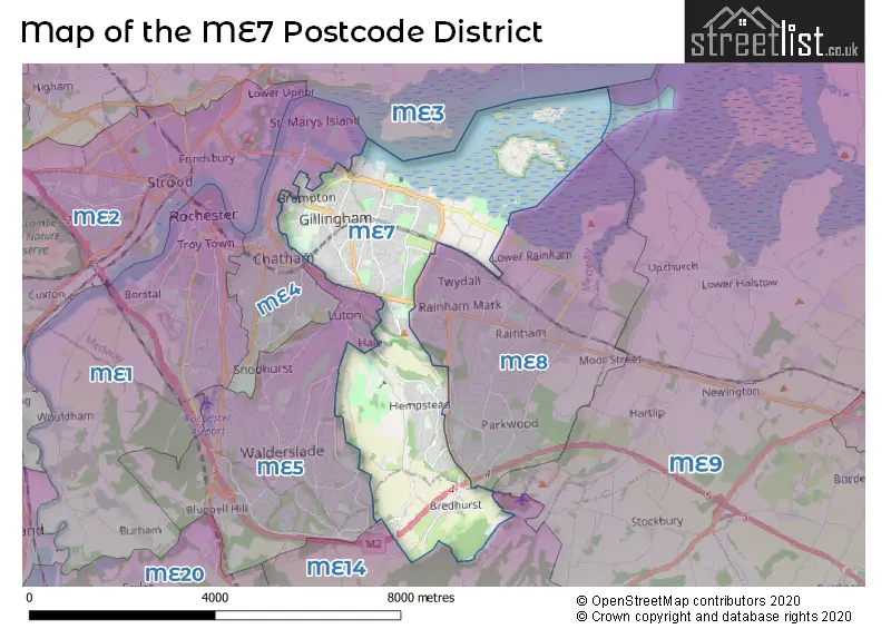
The ME7 Postcode shares a border with ME4 (CHATHAM, St. Marys Island), ME5 (CHATHAM, Walderslade, Blue Bell Hill), ME14 (MAIDSTONE, Bearsted, Weavering) and ME8 (GILLINGHAM, Rainham).
The primary settlement in the ME7 postcode district is Gillingham, located in the county of Kent, England. Other significant settlements in the district include Bredhurst, Hempstead, Lidsing, and Brompton. Gillingham is also the most significant post town in the district.
For the district ME7, we have data on 6 postcode sectors. Here's a breakdown: The sector ME7 1, covers Gillingham in Kent. The sector ME7 2, covers Gillingham in Kent. The sector ME7 3, covers Hempstead and Gillingham and Bredhurst in Kent. The sector ME7 4, covers Gillingham in Kent. The sector ME7 5, covers Gillingham in Kent. The sector ME7 9 is non-geographic. It's often designated for PO Boxes, large organisations, or special services.

Map of the ME7 Postcode District
Explore the ME7 postcode district by using our free interactive map.
When it comes to local government, postal geography often disregards political borders. However, for a breakdown in the ME7 District: the district mostly encompasses the Medway (B) (998 postcodes), and finally, the Maidstone District (B) area (26 postcodes).
Recent House Sales in ME7
| Date | Price | Address |
|---|---|---|
| 06/10/2023 | £180,000 | Gardiner Street, Gillingham, ME7 1DN |
| 25/09/2023 | £230,000 | West Street, Gillingham, ME7 1EE |
| 22/09/2023 | £225,000 | St Marys Road, Gillingham, ME7 1JL |
| 21/09/2023 | £500,000 | Kingsway, Gillingham, ME7 3BD |
| 18/09/2023 | £675,000 | Hempstead Road, Hempstead, Gillingham, ME7 3RH |
| 15/09/2023 | £255,000 | May Road, Gillingham, ME7 5UZ |
| 06/09/2023 | £237,000 | St Andrews Road, Gillingham, ME7 1QR |
| 05/09/2023 | £1,120,000 | High Street, Gillingham, ME7 1BS |
| 01/09/2023 | £230,000 | East Street, Gillingham, ME7 1EH |
| 01/09/2023 | £425,000 | Stuart Road, Gillingham, ME7 4AB |
Where is the ME7 Postcode District?
The postcode district ME7 is located in Gillingham. Gillingham is surrounded by several nearby towns. To the west is Chatham, which is approximately 1.68 miles away. Aylesford is situated to the southwest, about 5.27 miles away. Maidstone lies to the south, at a distance of around 7.22 miles. Sittingbourne is located to the east, approximately 7.53 miles away. Queenborough is situated to the northeast, at a distance of about 8.64 miles. Gravesend is found to the northwest, about 9.45 miles away. In addition, Gillingham is 31.52 miles away from the center of London.
The district is within the post town of GILLINGHAM.
The sector has postcodes within the nation of England.
The ME7 Postcode District is covers the following regions.
- Medway - Kent - South East (England)
- Mid Kent - Kent - South East (England)
| Postcode Sector | Delivery Office |
|---|---|
| ME7 0 | Rainham (me) Delivery Office |
| ME7 1 | Rainham (me) Delivery Office |
| ME7 1 | Gillingham (me) Delivery Office |
| ME7 2 | Rainham (me) Delivery Office |
| ME7 2 | Gillingham (me) Delivery Office |
| ME7 3 | Rainham (me) Delivery Office |
| ME7 4 | Gillingham (me) Delivery Office |
| ME7 5 | Gillingham (me) Delivery Office |
| M | E | 7 | - | X | X | X |
| M | E | 7 | Space | Numeric | Letter | Letter |
Current Monthly Rental Prices
| # Bedrooms | Min Price | Max Price | Avg Price |
|---|---|---|---|
| £500 | £780 | £633 | |
| 1 | £525 | £1,200 | £785 |
| 2 | £1,099 | £1,595 | £1,280 |
| 3 | £1,100 | £1,550 | £1,373 |
| 4 | £425 | £2,300 | £1,695 |
| 5 | £1,950 | £1,950 | £1,950 |
Current House Prices
| # Bedrooms | Min Price | Max Price | Avg Price |
|---|---|---|---|
| £25,000 | £220,000 | £108,333 | |
| 1 | £83,000 | £250,000 | £180,275 |
| 2 | £130,000 | £525,000 | £259,282 |
| 3 | £158,500 | £650,000 | £326,340 |
| 4 | £160,000 | £1,000,000 | £492,449 |
| 5 | £380,000 | £1,500,000 | £644,615 |
| 6 | £425,000 | £1,100,000 | £725,000 |
| 7 | £930,000 | £1,300,000 | £1,115,000 |
| 8 | £399,995 | £399,995 | £399,995 |
Estate Agents who Operate in the ME7 District
| Logo | Name | Brand Name | Address | Contact Number | Total Properties |
|---|---|---|---|---|---|
 | Gillingham | Your Move | 79 Balmoral Road, Gillingham, ME7 4PD | 01634 563399 | 20 |
 | Rainham | Robinson Michael & Jackson | 17 High Street Rainham ME8 7HX | 01634 561140 | 18 |
 | Gillingham | Purpleproperty | 428 Canterbury Street Gillingham ME7 5LE | 01634 855000 | 18 |
 | Gillingham | Wards | 109 High Street, Gillingham, Kent, ME7 1BS | 01634 949955 | 17 |
 | Gillingham | Mann | 88 High Street, Gillingham, Kent, ME7 1AX | 01634 557442 | 13 |
| Type of Property | 2018 Average | 2018 Sales | 2017 Average | 2017 Sales | 2016 Average | 2016 Sales | 2015 Average | 2015 Sales |
|---|---|---|---|---|---|---|---|---|
| Detached | £484,499 | 45 | £439,955 | 78 | £372,400 | 64 | £357,096 | 95 |
| Semi-Detached | £291,116 | 114 | £286,247 | 108 | £265,404 | 110 | £233,850 | 104 |
| Terraced | £212,144 | 506 | £208,532 | 533 | £191,198 | 642 | £165,217 | 629 |
| Flats | £173,602 | 107 | £194,854 | 291 | £158,955 | 175 | £151,696 | 189 |