The ME8 postcode district is a postal district located in the ME Medway postcode area with a population of 50,824 residents according to the 2021 England and Wales Census.
The area of the ME8 postcode district is 7.24 square miles which is 18.74 square kilometres or 4,631.59 acres.
Currently, the ME8 district has about 1119 postcode units spread across 5 geographic postcode sectors.
Given that each sector allows for 400 unique postcode combinations, the district has a capacity of 2,000 postcodes. With 1119 postcodes already in use, this leaves 881 units available.
The largest settlements in the ME8 postal code are GILLINGHAM and Rainham.
The postcode area has a boundary with Thames Estuary.
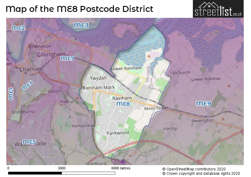
The ME8 Postcode shares a border with ME9 (Iwade, Teynham, Newington) and ME7 (GILLINGHAM, Hempstead).
The primary settlement in the ME8 postcode district is Gillingham, which is located in the county of Kent in England. Other significant settlements in the district include Rainham. The post town for the ME8 postcode is Gillingham.
For the district ME8, we have data on 6 postcode sectors. Here's a breakdown: The sector ME8 0, covers Gillingham in Kent. The sector ME8 1 is non-geographic. It's often designated for PO Boxes, large organisations, or special services. The sector ME8 6, covers Gillingham in Kent. The sector ME8 7, covers Rainham in Kent. The sector ME8 8, covers Rainham in Kent. The sector ME8 9, covers Gillingham in Kent.

Map of the ME8 Postcode District
Explore the ME8 postcode district by using our free interactive map.
When it comes to local government, postal geography often disregards political borders. However, for a breakdown in the ME8 District: the district mostly encompasses the Medway (B) (1113 postcodes), and finally, the Swale District (B) area (28 postcodes).
Recent House Sales in ME8
| Date | Price | Address |
|---|---|---|
| 24/10/2023 | £440,000 | Edwards Close, Gillingham, ME8 0PB |
| 02/10/2023 | £210,000 | Wyvill Close, Gillingham, ME8 9NE |
| 29/09/2023 | £300,000 | Holmoaks, Rainham, Gillingham, ME8 7DQ |
| 29/09/2023 | £480,000 | Tudor Grove, Gillingham, ME8 9AF |
| 28/09/2023 | £267,000 | London Road, Gillingham, ME8 6YX |
| 27/09/2023 | £422,000 | Hurst Place, Gillingham, ME8 9AS |
| 26/09/2023 | £335,000 | Willowby Gardens, Rainham, Gillingham, ME8 8TB |
| 19/09/2023 | £230,000 | Ten Acre Way, Rainham, Gillingham, ME8 8TL |
| 15/09/2023 | £510,000 | Herbert Road, Gillingham, ME8 9BZ |
| 15/09/2023 | £265,000 | Thorpe Walk, Gillingham, ME8 9QT |
Weather Forecast for ME8
Press Button to Show Forecast for Rochester Youth Hostel
| Time Period | Icon | Description | Temperature | Rain Probability | Wind |
|---|---|---|---|---|---|
| 09:00 to 12:00 | Overcast | 9.0°C (feels like 7.0°C) | 44.00% | ENE 9 mph | |
| 12:00 to 15:00 | Light rain | 11.0°C (feels like 9.0°C) | 46.00% | ENE 11 mph | |
| 15:00 to 18:00 | Cloudy | 11.0°C (feels like 9.0°C) | 17.00% | ENE 9 mph | |
| 18:00 to 21:00 | Light rain | 10.0°C (feels like 8.0°C) | 57.00% | ENE 11 mph | |
| 21:00 to 00:00 | Heavy rain | 10.0°C (feels like 7.0°C) | 92.00% | NE 11 mph |
Press Button to Show Forecast for Rochester Youth Hostel
| Time Period | Icon | Description | Temperature | Rain Probability | Wind |
|---|---|---|---|---|---|
| 00:00 to 03:00 | Heavy rain | 10.0°C (feels like 8.0°C) | 93.00% | NE 9 mph | |
| 03:00 to 06:00 | Heavy rain shower (night) | 10.0°C (feels like 8.0°C) | 80.00% | SE 9 mph | |
| 06:00 to 09:00 | Light rain | 10.0°C (feels like 7.0°C) | 50.00% | S 11 mph | |
| 09:00 to 12:00 | Light rain shower (day) | 11.0°C (feels like 8.0°C) | 52.00% | SW 11 mph | |
| 12:00 to 15:00 | Light rain shower (day) | 10.0°C (feels like 7.0°C) | 42.00% | W 16 mph | |
| 15:00 to 18:00 | Overcast | 10.0°C (feels like 8.0°C) | 17.00% | W 13 mph | |
| 18:00 to 21:00 | Cloudy | 11.0°C (feels like 9.0°C) | 8.00% | WSW 9 mph | |
| 21:00 to 00:00 | Clear night | 8.0°C (feels like 6.0°C) | 2.00% | SW 9 mph |
Press Button to Show Forecast for Rochester Youth Hostel
| Time Period | Icon | Description | Temperature | Rain Probability | Wind |
|---|---|---|---|---|---|
| 00:00 to 03:00 | Clear night | 7.0°C (feels like 5.0°C) | 1.00% | SW 7 mph | |
| 03:00 to 06:00 | Clear night | 6.0°C (feels like 4.0°C) | 1.00% | SSW 7 mph | |
| 06:00 to 09:00 | Sunny day | 7.0°C (feels like 6.0°C) | 1.00% | S 4 mph | |
| 09:00 to 12:00 | Cloudy | 12.0°C (feels like 10.0°C) | 4.00% | S 9 mph | |
| 12:00 to 15:00 | Partly cloudy (day) | 14.0°C (feels like 12.0°C) | 2.00% | S 11 mph | |
| 15:00 to 18:00 | Partly cloudy (day) | 14.0°C (feels like 12.0°C) | 2.00% | S 11 mph | |
| 18:00 to 21:00 | Sunny day | 13.0°C (feels like 12.0°C) | 3.00% | S 7 mph | |
| 21:00 to 00:00 | Partly cloudy (night) | 9.0°C (feels like 8.0°C) | 1.00% | SE 7 mph |
Press Button to Show Forecast for Rochester Youth Hostel
| Time Period | Icon | Description | Temperature | Rain Probability | Wind |
|---|---|---|---|---|---|
| 00:00 to 03:00 | Partly cloudy (night) | 9.0°C (feels like 7.0°C) | 2.00% | ESE 7 mph | |
| 03:00 to 06:00 | Clear night | 8.0°C (feels like 7.0°C) | 2.00% | SE 7 mph | |
| 06:00 to 09:00 | Cloudy | 9.0°C (feels like 8.0°C) | 7.00% | SE 7 mph | |
| 09:00 to 12:00 | Cloudy | 13.0°C (feels like 12.0°C) | 6.00% | SE 7 mph | |
| 12:00 to 15:00 | Cloudy | 15.0°C (feels like 14.0°C) | 10.00% | SE 9 mph | |
| 15:00 to 18:00 | Cloudy | 16.0°C (feels like 14.0°C) | 9.00% | SE 9 mph | |
| 18:00 to 21:00 | Cloudy | 14.0°C (feels like 13.0°C) | 17.00% | ESE 9 mph | |
| 21:00 to 00:00 | Cloudy | 12.0°C (feels like 11.0°C) | 20.00% | E 7 mph |
Where is the ME8 Postcode District?
The postcode district ME8 is located in the town of Gillingham. Gillingham is situated in close proximity to several nearby towns. To the west, there is Chatham, which is approximately 3.31 miles away. To the east, there is Sittingbourne, which is approximately 5.89 miles away. Aylesford is located to the southwest and is roughly 6.44 miles away. Lastly, Queenborough is situated to the northeast and is around 7.20 miles away. Additionally, Gillingham is situated at a distance of 33.11 miles from the center of London.
The district is within the post town of GILLINGHAM.
The sector has postcodes within the nation of England.
The ME8 Postcode District is covers the following regions.
- Medway - Kent - South East (England)
- Kent Thames Gateway - Kent - South East (England)
| Postcode Sector | Delivery Office |
|---|---|
| ME8 0 | Rainham (me) Delivery Office |
| ME8 6 | Rainham (me) Delivery Office |
| ME8 7 | Rainham (me) Delivery Office |
| ME8 8 | Rainham (me) Delivery Office |
| ME8 9 | Rainham (me) Delivery Office |
| M | E | 8 | - | X | X | X |
| M | E | 8 | Space | Numeric | Letter | Letter |
Current Monthly Rental Prices
| # Bedrooms | Min Price | Max Price | Avg Price |
|---|---|---|---|
| £90 | £825 | £458 | |
| 1 | £900 | £975 | £942 |
| 2 | £875 | £1,100 | £988 |
| 3 | £1,500 | £1,550 | £1,517 |
| 4 | £2,495 | £2,495 | £2,495 |
| 5 | £2,750 | £2,750 | £2,750 |
Current House Prices
| # Bedrooms | Min Price | Max Price | Avg Price |
|---|---|---|---|
| £700,000 | £700,000 | £700,000 | |
| 1 | £65,000 | £300,000 | £165,202 |
| 2 | £99,000 | £425,000 | £265,525 |
| 3 | £178,500 | £695,000 | £381,952 |
| 4 | £260,000 | £950,000 | £547,775 |
| 5 | £425,000 | £925,000 | £678,800 |
| 6 | £575,000 | £700,000 | £637,500 |
Estate Agents who Operate in the ME8 District
| Logo | Name | Brand Name | Address | Contact Number | Total Properties |
|---|---|---|---|---|---|
 | Rainham | Wards | 19 High Street, Rainham, Gillingham, Kent, ME8 7HZ | 01634 949538 | 28 |
 | Rainham | Jacksons Estate Agents | High Street, Rainham, ME8 7JH | 01634 563743 | 26 |
 | Rainham | Robinson Michael & Jackson | 17 High Street Rainham ME8 7HX | 01634 561140 | 23 |
 | Rainham | Harrisons Reeve | 35 High Street, Rainham, ME8 7HS | 01634 563441 | 16 |
 | Rainham | Your Move | 84 High Street, Rainham, Kent, ME8 7JJ | 01634 563342 | 15 |
| Type of Property | 2018 Average | 2018 Sales | 2017 Average | 2017 Sales | 2016 Average | 2016 Sales | 2015 Average | 2015 Sales |
|---|---|---|---|---|---|---|---|---|
| Detached | £442,452 | 153 | £408,664 | 138 | £408,371 | 118 | £348,833 | 160 |
| Semi-Detached | £300,170 | 278 | £292,993 | 287 | £268,633 | 281 | £239,286 | 232 |
| Terraced | £250,073 | 311 | £241,381 | 349 | £223,866 | 324 | £195,347 | 329 |
| Flats | £173,978 | 66 | £152,602 | 61 | £143,045 | 65 | £124,677 | 65 |