The MK8 8 postcode sector is within the county of Buckinghamshire.
Did you know? According to the 2021 Census, the MK8 8 postcode sector is home to a bustling 4,214 residents!
Given that each sector allows for 400 unique postcode combinations. Letters C, I, K, M, O and V are not allowed in the last two letters of a postcode. With 127 postcodes already in use, this leaves 273 units available.
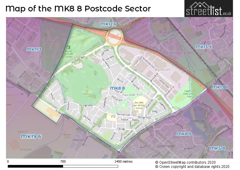
The largest settlements in the MK8 8 postal code are Two Mile Ash and Wymbush.
The MK8 8 Postcode shares a border with MK13 8 (Bradwell Common, Rooksley), MK13 9 (Bradwell, Bradwell Abbey), MK19 6 (Deanshanger, Old Stratford, Wicken), MK11 3 (Kiln Farm), MK8 9 (Great Holm, Loughton Lodge), MK8 0 (Crownhill, Grange Farm) and MK12 6 (Greenleys, Stacey Bushes, Hodge Lea).
The sector is within the post town of MILTON KEYNES.
MK8 8 is a postcode sector within the MK8 postcode district which is within the MK Milton Keynes postcode area.
The Royal Mail delivery office for the MK8 8 postal sector is the Kiln Farm Delivery Office.
The area of the MK8 8 postcode sector is 0.76 square miles which is 1.96 square kilometres or 483.43 square acres.
The MK8 8 postcode sector is crossed by the A5 Major A road.

Map of the MK8 8 Postcode Sector
Explore the MK8 8 postcode sector by using our free interactive map.
| M | K | 8 | - | 8 | X | X |
| M | K | 8 | Space | 8 | Letter | Letter |
Official List of Streets
Two Mile Ash (54 Streets)
Wymbush (2 Streets)
Unofficial Streets or Alternative Spellings
Crownhill
DANSTEED WAYCalverton
CALVERTON LANEElfield Park
WATLING STREETBlakelands
MONKS WAYWeather Forecast for MK8 8
Press Button to Show Forecast for Bradwell Village Youth Hostel
| Time Period | Icon | Description | Temperature | Rain Probability | Wind |
|---|---|---|---|---|---|
| 06:00 to 09:00 | Cloudy | 5.0°C (feels like 2.0°C) | 49.00% | NE 9 mph | |
| 09:00 to 12:00 | Overcast | 7.0°C (feels like 4.0°C) | 48.00% | NE 11 mph | |
| 12:00 to 15:00 | Overcast | 8.0°C (feels like 5.0°C) | 14.00% | ENE 11 mph | |
| 15:00 to 18:00 | Overcast | 9.0°C (feels like 6.0°C) | 14.00% | NE 11 mph | |
| 18:00 to 21:00 | Overcast | 9.0°C (feels like 6.0°C) | 21.00% | NE 13 mph | |
| 21:00 to 00:00 | Overcast | 7.0°C (feels like 4.0°C) | 61.00% | NNE 13 mph |
Press Button to Show Forecast for Bradwell Village Youth Hostel
| Time Period | Icon | Description | Temperature | Rain Probability | Wind |
|---|---|---|---|---|---|
| 00:00 to 03:00 | Heavy rain | 7.0°C (feels like 4.0°C) | 85.00% | NNE 13 mph | |
| 03:00 to 06:00 | Heavy rain | 7.0°C (feels like 3.0°C) | 91.00% | NNE 13 mph | |
| 06:00 to 09:00 | Heavy rain | 7.0°C (feels like 3.0°C) | 89.00% | NNW 11 mph | |
| 09:00 to 12:00 | Heavy rain | 7.0°C (feels like 4.0°C) | 81.00% | NW 11 mph | |
| 12:00 to 15:00 | Light rain | 8.0°C (feels like 5.0°C) | 49.00% | WNW 13 mph | |
| 15:00 to 18:00 | Cloudy | 10.0°C (feels like 7.0°C) | 16.00% | W 9 mph | |
| 18:00 to 21:00 | Cloudy | 10.0°C (feels like 8.0°C) | 7.00% | WSW 7 mph | |
| 21:00 to 00:00 | Partly cloudy (night) | 7.0°C (feels like 5.0°C) | 2.00% | SSW 7 mph |
Press Button to Show Forecast for Bradwell Village Youth Hostel
| Time Period | Icon | Description | Temperature | Rain Probability | Wind |
|---|---|---|---|---|---|
| 00:00 to 03:00 | Clear night | 6.0°C (feels like 4.0°C) | 2.00% | SW 7 mph | |
| 03:00 to 06:00 | Clear night | 5.0°C (feels like 2.0°C) | 1.00% | SSW 7 mph | |
| 06:00 to 09:00 | Sunny day | 6.0°C (feels like 3.0°C) | 1.00% | S 7 mph | |
| 09:00 to 12:00 | Partly cloudy (day) | 11.0°C (feels like 9.0°C) | 1.00% | S 11 mph | |
| 12:00 to 15:00 | Cloudy | 13.0°C (feels like 11.0°C) | 5.00% | S 11 mph | |
| 15:00 to 18:00 | Partly cloudy (day) | 14.0°C (feels like 12.0°C) | 2.00% | S 13 mph | |
| 18:00 to 21:00 | Sunny day | 13.0°C (feels like 11.0°C) | 1.00% | S 9 mph | |
| 21:00 to 00:00 | Clear night | 9.0°C (feels like 7.0°C) | 1.00% | SSE 7 mph |
Press Button to Show Forecast for Bradwell Village Youth Hostel
| Time Period | Icon | Description | Temperature | Rain Probability | Wind |
|---|---|---|---|---|---|
| 00:00 to 03:00 | Clear night | 8.0°C (feels like 6.0°C) | 2.00% | SE 7 mph | |
| 03:00 to 06:00 | Clear night | 8.0°C (feels like 5.0°C) | 3.00% | SE 7 mph | |
| 06:00 to 09:00 | Sunny day | 8.0°C (feels like 6.0°C) | 3.00% | ESE 7 mph | |
| 09:00 to 12:00 | Sunny day | 13.0°C (feels like 11.0°C) | 3.00% | SE 9 mph | |
| 12:00 to 15:00 | Cloudy | 16.0°C (feels like 14.0°C) | 7.00% | SE 11 mph | |
| 15:00 to 18:00 | Cloudy | 16.0°C (feels like 14.0°C) | 8.00% | SE 9 mph | |
| 18:00 to 21:00 | Cloudy | 15.0°C (feels like 13.0°C) | 10.00% | ESE 9 mph | |
| 21:00 to 00:00 | Clear night | 12.0°C (feels like 11.0°C) | 7.00% | ESE 7 mph |
House Prices in the MK8 8 Postcode Sector
| Type of Property | 2018 Average | 2018 Sales | 2017 Average | 2017 Sales | 2016 Average | 2016 Sales | 2015 Average | 2015 Sales |
|---|---|---|---|---|---|---|---|---|
| Detached | £368,571 | 21 | £374,000 | 24 | £396,481 | 27 | £344,463 | 27 |
| Semi-Detached | £211,893 | 14 | £212,429 | 21 | £193,100 | 10 | £219,111 | 9 |
| Terraced | £191,200 | 10 | £172,736 | 11 | £164,182 | 27 | £157,820 | 15 |
| Flats | £118,533 | 9 | £95,355 | 11 | £102,558 | 26 | £94,214 | 14 |
Important Postcodes MK8 8 in the Postcode Sector
MK8 8LH is the postcode for Two Mile Ash School, The High Street, Two Mile Ash, and Two Mile Ash School, The High Street
MK8 8NA is the postcode for Ashbrook School, 38 The High Street, Two Mile Ash, and Ashbrook School, 38 The High Street
| The MK8 8 Sector is within these Local Authorities |
|
|---|---|
| The MK8 8 Sector is within these Counties |
|
| The MK8 8 Sector is within these Water Company Areas |
|