Given that each sector allows for 400 unique postcode combinations. Letters C, I, K, M, O and V are not allowed in the last two letters of a postcode. With 238 postcodes already in use, this leaves 162 units available.
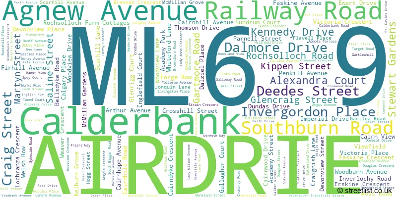
The largest settlements in the ML6 9 postal code are AIRDRIE and Calderbank.
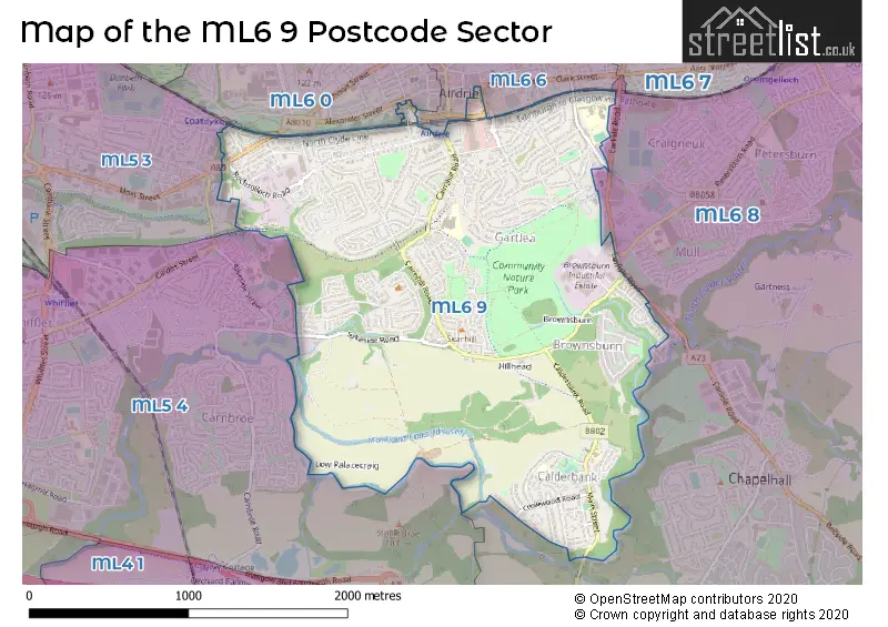
The ML6 9 Postcode shares a border with ML5 4 (COATBRIDGE), ML6 0 (AIRDRIE, Glenmavis), ML6 8 (AIRDRIE, Chapelhall, Caldercruix), ML5 3 (COATBRIDGE) and ML6 6 (AIRDRIE).
The sector is within the post town of AIRDRIE.
ML6 9 is a postcode sector within the ML6 postcode district which is within the ML Motherwell postcode area.
The Royal Mail delivery office for the ML6 9 postal sector is the Airdrie Delivery Office.
The area of the ML6 9 postcode sector is 2.06 square miles which is 5.35 square kilometres or 1,321.28 square acres.

Map of the ML6 9 Postcode Sector
Explore the ML6 9 postcode sector by using our free interactive map.
| M | L | 6 | - | 9 | X | X |
| M | L | 6 | Space | 9 | Letter | Letter |
Official List of Streets
AIRDRIE (135 Streets)
Calderbank (25 Streets)
Unofficial Streets or Alternative Spellings
Chapelhall
CARLISLE ROAD ALEXANDER COURT BALLIES ROUNDABOUT CROW-WOOD CRESCENT CROW-WOOD ROAD GARTFIELD STREET KNOCK DRIVE LADY ANN CRESCENT LAUREN VIEW LIVINGSTONE PLACE NINIAN ROAD PINE GROVE PIPER ROAD SOUTH BURN ROAD STRATHBEG COURT THE NORTH CALDER HERITAGE TRAIL VIKING ROAD WEAVERS ROAD WOODHALL MILL ROADAIRDRIE
ALEXANDER STREET BROOMKNOLL STREET CENTENARY AVENUE PETERSBURN ROADCOATBRIDGE
LOCKS STREET LOMOND COURT MAIN STREET PADDOCK STREETAIRDRIE,
AGNEW AVENUEWeather Forecast for ML6 9
Press Button to Show Forecast for Airdrie
| Time Period | Icon | Description | Temperature | Rain Probability | Wind |
|---|---|---|---|---|---|
| 06:00 to 09:00 | Sunny day | 3.0°C (feels like 1.0°C) | 0.00% | SE 4 mph | |
| 09:00 to 12:00 | Cloudy | 7.0°C (feels like 6.0°C) | 4.00% | SSE 2 mph | |
| 12:00 to 15:00 | Cloudy | 9.0°C (feels like 9.0°C) | 5.00% | ESE 4 mph | |
| 15:00 to 18:00 | Cloudy | 10.0°C (feels like 8.0°C) | 6.00% | ESE 7 mph | |
| 18:00 to 21:00 | Cloudy | 8.0°C (feels like 7.0°C) | 8.00% | NE 7 mph | |
| 21:00 to 00:00 | Cloudy | 7.0°C (feels like 5.0°C) | 5.00% | NE 4 mph |
Press Button to Show Forecast for Airdrie
| Time Period | Icon | Description | Temperature | Rain Probability | Wind |
|---|---|---|---|---|---|
| 00:00 to 03:00 | Cloudy | 5.0°C (feels like 3.0°C) | 4.00% | ESE 4 mph | |
| 03:00 to 06:00 | Clear night | 3.0°C (feels like 1.0°C) | 1.00% | E 4 mph | |
| 06:00 to 09:00 | Sunny day | 3.0°C (feels like 1.0°C) | 1.00% | ENE 4 mph | |
| 09:00 to 12:00 | Partly cloudy (day) | 7.0°C (feels like 5.0°C) | 1.00% | NNE 7 mph | |
| 12:00 to 15:00 | Cloudy | 10.0°C (feels like 9.0°C) | 7.00% | NNW 7 mph | |
| 15:00 to 18:00 | Cloudy | 11.0°C (feels like 9.0°C) | 7.00% | NW 7 mph | |
| 18:00 to 21:00 | Cloudy | 10.0°C (feels like 7.0°C) | 5.00% | WSW 9 mph | |
| 21:00 to 00:00 | Clear night | 7.0°C (feels like 5.0°C) | 2.00% | SW 7 mph |
Press Button to Show Forecast for Airdrie
| Time Period | Icon | Description | Temperature | Rain Probability | Wind |
|---|---|---|---|---|---|
| 00:00 to 03:00 | Partly cloudy (night) | 5.0°C (feels like 3.0°C) | 2.00% | SSW 7 mph | |
| 03:00 to 06:00 | Cloudy | 5.0°C (feels like 3.0°C) | 7.00% | S 7 mph | |
| 06:00 to 09:00 | Cloudy | 6.0°C (feels like 4.0°C) | 8.00% | SSE 7 mph | |
| 09:00 to 12:00 | Cloudy | 10.0°C (feels like 7.0°C) | 11.00% | S 11 mph | |
| 12:00 to 15:00 | Light rain | 11.0°C (feels like 8.0°C) | 54.00% | S 13 mph | |
| 15:00 to 18:00 | Light rain shower (day) | 12.0°C (feels like 9.0°C) | 39.00% | S 16 mph | |
| 18:00 to 21:00 | Cloudy | 11.0°C (feels like 9.0°C) | 9.00% | S 11 mph | |
| 21:00 to 00:00 | Cloudy | 10.0°C (feels like 7.0°C) | 8.00% | SE 9 mph |
Press Button to Show Forecast for Airdrie
| Time Period | Icon | Description | Temperature | Rain Probability | Wind |
|---|---|---|---|---|---|
| 00:00 to 03:00 | Partly cloudy (night) | 9.0°C (feels like 6.0°C) | 4.00% | SE 9 mph | |
| 03:00 to 06:00 | Partly cloudy (night) | 8.0°C (feels like 6.0°C) | 3.00% | SE 9 mph | |
| 06:00 to 09:00 | Partly cloudy (day) | 8.0°C (feels like 6.0°C) | 3.00% | ESE 9 mph | |
| 09:00 to 12:00 | Partly cloudy (day) | 11.0°C (feels like 9.0°C) | 2.00% | ESE 11 mph | |
| 12:00 to 15:00 | Partly cloudy (day) | 14.0°C (feels like 11.0°C) | 4.00% | SE 13 mph | |
| 15:00 to 18:00 | Cloudy | 14.0°C (feels like 11.0°C) | 10.00% | ESE 11 mph | |
| 18:00 to 21:00 | Cloudy | 13.0°C (feels like 11.0°C) | 12.00% | E 11 mph | |
| 21:00 to 00:00 | Cloudy | 10.0°C (feels like 8.0°C) | 9.00% | ENE 9 mph |
| The ML6 9 Sector is within these Local Authorities | |
|---|---|
| The ML6 9 Sector is within these Counties | |
| The ML6 9 Sector is within these Water Company Areas |