The NG15 6 postcode sector is within the county of Nottinghamshire.
Did you know? According to the 2021 Census, the NG15 6 postcode sector is home to a bustling 16,616 residents!
Given that each sector allows for 400 unique postcode combinations. Letters C, I, K, M, O and V are not allowed in the last two letters of a postcode. With 327 postcodes already in use, this leaves 73 units available.
The NG15 6 postal code covers the settlement of Hucknall.
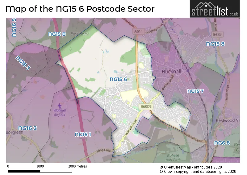
The NG15 6 Postcode shares a border with NG15 0 (Annesley, Newstead Village), NG15 8 (Hucknall, Linby, Papplewick), NG6 8 (NOTTINGHAM, Bestwood Village, Bulwell), NG15 7 (Hucknall), NG16 1 (Nuthall, Watnall) and NG16 2 (Kimberley, Newthorpe, Giltbrook).
The sector is within the post town of NOTTINGHAM.
NG15 6 is a postcode sector within the NG15 postcode district which is within the NG Nottingham postcode area.
The Royal Mail delivery office for the NG15 6 postal sector is the Hucknall Delivery Office.
The area of the NG15 6 postcode sector is 3.06 square miles which is 7.94 square kilometres or 1,961.37 square acres.
The NG15 6 postcode sector is crossed by the M1 motorway.

Map of the NG15 6 Postcode Sector
Explore the NG15 6 postcode sector by using our free interactive map.
| N | G | 1 | 5 | - | 6 | X | X |
| N | G | 1 | 5 | Space | 6 | Letter | Letter |
Official List of Streets
Hucknall (243 Streets)
Unofficial Streets or Alternative Spellings
Weather Forecast for NG15 6
Press Button to Show Forecast for Westville
| Time Period | Icon | Description | Temperature | Rain Probability | Wind |
|---|---|---|---|---|---|
| 00:00 to 03:00 | Partly cloudy (night) | 3.0°C (feels like 2.0°C) | 1.00% | NE 4 mph | |
| 03:00 to 06:00 | Cloudy | 2.0°C (feels like 0.0°C) | 4.00% | NNE 4 mph | |
| 06:00 to 09:00 | Sunny day | 3.0°C (feels like 0.0°C) | 1.00% | NNE 7 mph | |
| 09:00 to 12:00 | Cloudy | 7.0°C (feels like 5.0°C) | 5.00% | NE 7 mph | |
| 12:00 to 15:00 | Overcast | 9.0°C (feels like 8.0°C) | 9.00% | ENE 4 mph | |
| 15:00 to 18:00 | Cloudy | 9.0°C (feels like 8.0°C) | 8.00% | ENE 4 mph | |
| 18:00 to 21:00 | Cloudy | 8.0°C (feels like 5.0°C) | 11.00% | ENE 9 mph | |
| 21:00 to 00:00 | Cloudy | 5.0°C (feels like 3.0°C) | 10.00% | ENE 7 mph |
Press Button to Show Forecast for Westville
| Time Period | Icon | Description | Temperature | Rain Probability | Wind |
|---|---|---|---|---|---|
| 00:00 to 03:00 | Partly cloudy (night) | 4.0°C (feels like 2.0°C) | 8.00% | NE 4 mph | |
| 03:00 to 06:00 | Cloudy | 3.0°C (feels like 1.0°C) | 11.00% | NE 7 mph | |
| 06:00 to 09:00 | Cloudy | 4.0°C (feels like 1.0°C) | 10.00% | NE 7 mph | |
| 09:00 to 12:00 | Cloudy | 8.0°C (feels like 5.0°C) | 12.00% | ENE 9 mph | |
| 12:00 to 15:00 | Cloudy | 9.0°C (feels like 7.0°C) | 18.00% | ENE 9 mph | |
| 15:00 to 18:00 | Cloudy | 10.0°C (feels like 8.0°C) | 18.00% | ENE 11 mph | |
| 18:00 to 21:00 | Overcast | 9.0°C (feels like 6.0°C) | 21.00% | ENE 11 mph | |
| 21:00 to 00:00 | Cloudy | 7.0°C (feels like 4.0°C) | 15.00% | NE 11 mph |
Press Button to Show Forecast for Westville
| Time Period | Icon | Description | Temperature | Rain Probability | Wind |
|---|---|---|---|---|---|
| 00:00 to 03:00 | Overcast | 7.0°C (feels like 3.0°C) | 22.00% | NE 11 mph | |
| 03:00 to 06:00 | Light rain | 7.0°C (feels like 3.0°C) | 52.00% | NNE 13 mph | |
| 06:00 to 09:00 | Heavy rain | 7.0°C (feels like 3.0°C) | 77.00% | NNE 13 mph | |
| 09:00 to 12:00 | Heavy rain | 8.0°C (feels like 5.0°C) | 78.00% | NE 13 mph | |
| 12:00 to 15:00 | Heavy rain | 10.0°C (feels like 7.0°C) | 77.00% | N 13 mph | |
| 15:00 to 18:00 | Light rain shower (day) | 10.0°C (feels like 7.0°C) | 42.00% | N 11 mph | |
| 18:00 to 21:00 | Light rain shower (day) | 9.0°C (feels like 7.0°C) | 38.00% | NNE 9 mph | |
| 21:00 to 00:00 | Cloudy | 8.0°C (feels like 6.0°C) | 11.00% | SW 7 mph |
Schools and Places of Education Within the NG15 6 Postcode Sector
Broomhill Junior School
Community school
Broomhill Road, Nottingham, Nottinghamshire, NG15 6AJ
Head: Mr Andrew Beckinsale-Yates
Ofsted Rating: Good
Inspection: 2022-09-22 (582 days ago)
Website: Visit Broomhill Junior School Website
Phone: 01159525694
Number of Pupils: 273
Butler's Hill Infant and Nursery School
Community school
Broomhill Road, Nottingham, Nottinghamshire, NG15 6AJ
Head: Mrs Rachel Hallam
Ofsted Rating: Good
Inspection: 2023-03-14 (409 days ago)
Website: Visit Butler's Hill Infant and Nursery School Website
Phone: 01159525904
Number of Pupils: 240
Edgewood Primary and Nursery School
Community school
Edgewood Drive, Nottingham, Nottinghamshire, NG15 6HX
Head: Mr Ed Seeley
Ofsted Rating: Good
Inspection: 2020-03-11 (1507 days ago)
Website: Visit Edgewood Primary and Nursery School Website
Phone: 01159561337
Number of Pupils: 334
Hillside Primary and Nursery School
Academy converter
Roberts Lane, Nottingham, Nottinghamshire, NG15 6LW
Head: Mrs Rhian Richardson
Ofsted Rating: Good
Inspection: 2022-05-18 (709 days ago)
Website: Visit Hillside Primary and Nursery School Website
Phone: 01158401477
Number of Pupils: 468
Holgate Primary and Nursery School
Community school
High Leys Road, Hucknall, Nottinghamshire, NG15 6EZ
Head: Mrs Nicola Davies
Ofsted Rating: Good
Inspection: 2023-07-19 (282 days ago)
Website: Visit Holgate Primary and Nursery School Website
Phone: 01159638649
Number of Pupils: 368
The Holgate Academy
Academy sponsor led
Hillcrest Drive, Nottingham, Nottinghamshire, NG15 6PX
Head: Mrs Heather Widdup
Ofsted Rating: Serious Weaknesses
Inspection: 2022-06-15 (681 days ago)
Website: Visit The Holgate Academy Website
Phone: 01159632104
Number of Pupils: 1161
House Prices in the NG15 6 Postcode Sector
| Type of Property | 2018 Average | 2018 Sales | 2017 Average | 2017 Sales | 2016 Average | 2016 Sales | 2015 Average | 2015 Sales |
|---|---|---|---|---|---|---|---|---|
| Detached | £250,384 | 130 | £230,066 | 137 | £212,456 | 124 | £193,564 | 88 |
| Semi-Detached | £143,296 | 133 | £145,724 | 157 | £130,304 | 160 | £118,003 | 109 |
| Terraced | £125,261 | 70 | £138,720 | 90 | £115,955 | 81 | £119,904 | 71 |
| Flats | £84,750 | 6 | £78,143 | 7 | £98,994 | 19 | £72,499 | 4 |
Important Postcodes NG15 6 in the Postcode Sector
NG15 6AJ is the postcode for Butlers Hill Infant & Nursery School, Broomhill Road, Butlers Hill Infant & Nursery School, Broomhill Road, Hucknall, Broomhill Junior School, Broomhill Road, BUTLERS HILL INFANTS AND NURSERY SCHOOL, BROOMHILL ROAD, HUCKNALL, Butlers Hill & Broomhill Childrens Centre, Broomhill Road, Butlers Hill Infants And Nursery School, Broomhill Road, Butlers Hill Children's Centre, Broomhill Road, and BUTLER'S HILL & BROOMHILL CHILDREN'S CENTRE, Surestart Childrens Centre, Broomhill Road
NG15 6DY is the postcode for Torkard Hill Medical Centre, Farleys Lane, and Torkard Hill Medical Centre, Farleys Lane, Hucknall
NG15 6EZ is the postcode for Holgate Primary And Nursery School, High Leys Road, Annie Holgate Junior School, High Leys Road, and Holgate Primary and Nursery School, High Leys Road, Hucknall
NG15 6HB is the postcode for Jubilee Court Elderly Persons Home, Nabbs Lane
NG15 6HX is the postcode for Edgewood Drive Primary School, Edgewood Drive, and Edgewood Drive Primary School, Edgewood Drive, Hucknall
NG15 6LW is the postcode for Hillside Primary & Nursery School, Roberts Lane
NG15 6PX is the postcode for HILLCREST UPPER SCHOOL, The Holgate Academy, Hillcrest Drive, MAIN SCHOOL, The Holgate Academy, Hillcrest Drive, NABBS LOWER SCHOOL, The Holgate Academy, Hillcrest Drive, SCIENCE BLOCK, The Holgate Academy, Hillcrest Drive, LOWER SCHOOL, The Holgate Academy, Hillcrest Drive, and MUSIC & ADMIN BLOCK, The Holgate Academy, Hillcrest Drive
NG15 6SA is the postcode for Edgewood Leisure Centre, Christchurch Road
| The NG15 6 Sector is within these Local Authorities |
|
|---|---|
| The NG15 6 Sector is within these Counties |
|
| The NG15 6 Sector is within these Water Company Areas |
|