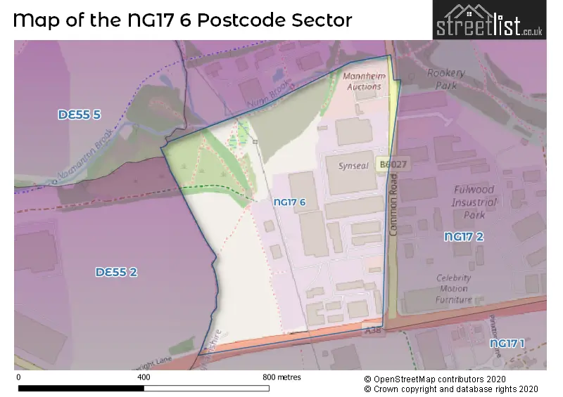
The NG17 6 postcode sector stands on the Derbyshire and Nottinghamshire border.
Given that each sector allows for 400 unique postcode combinations. Letters C, I, K, M, O and V are not allowed in the last two letters of a postcode. With 3 postcodes already in use, this leaves 397 units available.
The sector is within the post town of SUTTON-IN-ASHFIELD.
NG17 6 is a postcode sector within the NG17 postcode district which is within the NG Nottingham postcode area.
The Royal Mail delivery office for the NG17 6 postal sector is the Sutton-in-ashfield Delivery Office.
The area of the NG17 6 postcode sector is 0.19 square miles which is 0.49 square kilometres or 120.55 square acres.
Waterways within the NG17 6 postcode sector include the Blackwell Brook.

Map of the NG17 6 Postcode Sector
Explore the NG17 6 postcode sector by using our free interactive map.
| N | G | 1 | 7 | - | 6 | X | X |
| N | G | 1 | 7 | Space | 6 | Letter | Letter |
Official List of Streets
Huthwaite (2 Streets)
Unofficial Streets or Alternative Spellings
SUTTON-IN-ASHFIELD
ALFRETON ROAD FULWOOD ROAD NORTH CARTWIGHT LANE CARTWRIGHT LANESouth Normanton
BERRISTOW PLACEWeather Forecast for NG17 6
Press Button to Show Forecast for Kirkby In Ashfield
| Time Period | Icon | Description | Temperature | Rain Probability | Wind |
|---|---|---|---|---|---|
| 15:00 to 18:00 | Cloudy | 18.0°C (feels like 17.0°C) | 4.00% | SSW 7 mph | |
| 18:00 to 21:00 | Cloudy | 17.0°C (feels like 17.0°C) | 5.00% | SSW 7 mph | |
| 21:00 to 00:00 | Cloudy | 15.0°C (feels like 14.0°C) | 4.00% | WNW 4 mph |
Press Button to Show Forecast for Kirkby In Ashfield
| Time Period | Icon | Description | Temperature | Rain Probability | Wind |
|---|---|---|---|---|---|
| 00:00 to 03:00 | Cloudy | 13.0°C (feels like 13.0°C) | 5.00% | NW 4 mph | |
| 03:00 to 06:00 | Cloudy | 12.0°C (feels like 12.0°C) | 5.00% | WNW 2 mph | |
| 06:00 to 09:00 | Cloudy | 12.0°C (feels like 12.0°C) | 4.00% | WNW 2 mph | |
| 09:00 to 12:00 | Cloudy | 15.0°C (feels like 15.0°C) | 3.00% | WSW 2 mph | |
| 12:00 to 15:00 | Cloudy | 18.0°C (feels like 18.0°C) | 3.00% | SW 4 mph | |
| 15:00 to 18:00 | Cloudy | 20.0°C (feels like 19.0°C) | 3.00% | W 4 mph | |
| 18:00 to 21:00 | Cloudy | 19.0°C (feels like 18.0°C) | 3.00% | W 4 mph | |
| 21:00 to 00:00 | Cloudy | 15.0°C (feels like 14.0°C) | 3.00% | NNW 4 mph |
Press Button to Show Forecast for Kirkby In Ashfield
| Time Period | Icon | Description | Temperature | Rain Probability | Wind |
|---|---|---|---|---|---|
| 00:00 to 03:00 | Cloudy | 13.0°C (feels like 13.0°C) | 3.00% | N 4 mph | |
| 03:00 to 06:00 | Cloudy | 12.0°C (feels like 11.0°C) | 4.00% | NNW 2 mph | |
| 06:00 to 09:00 | Cloudy | 13.0°C (feels like 13.0°C) | 4.00% | NNW 2 mph | |
| 09:00 to 12:00 | Cloudy | 17.0°C (feels like 17.0°C) | 4.00% | SSE 2 mph | |
| 12:00 to 15:00 | Cloudy | 19.0°C (feels like 19.0°C) | 4.00% | S 4 mph | |
| 15:00 to 18:00 | Cloudy | 20.0°C (feels like 19.0°C) | 3.00% | SSE 4 mph | |
| 18:00 to 21:00 | Partly cloudy (day) | 19.0°C (feels like 19.0°C) | 1.00% | SSE 4 mph | |
| 21:00 to 00:00 | Clear night | 16.0°C (feels like 15.0°C) | 1.00% | SSE 4 mph |
Press Button to Show Forecast for Kirkby In Ashfield
| Time Period | Icon | Description | Temperature | Rain Probability | Wind |
|---|---|---|---|---|---|
| 00:00 to 03:00 | Clear night | 13.0°C (feels like 13.0°C) | 0.00% | S 4 mph | |
| 03:00 to 06:00 | Clear night | 11.0°C (feels like 11.0°C) | 0.00% | SSW 4 mph | |
| 06:00 to 09:00 | Sunny day | 13.0°C (feels like 13.0°C) | 1.00% | SSW 2 mph | |
| 09:00 to 12:00 | Sunny day | 17.0°C (feels like 17.0°C) | 0.00% | SSE 4 mph | |
| 12:00 to 15:00 | Partly cloudy (day) | 20.0°C (feels like 19.0°C) | 2.00% | SSE 7 mph | |
| 15:00 to 18:00 | Partly cloudy (day) | 21.0°C (feels like 19.0°C) | 2.00% | SSE 9 mph | |
| 18:00 to 21:00 | Cloudy | 20.0°C (feels like 19.0°C) | 5.00% | SSE 7 mph | |
| 21:00 to 00:00 | Partly cloudy (night) | 16.0°C (feels like 15.0°C) | 1.00% | SE 7 mph |
Press Button to Show Forecast for Kirkby In Ashfield
| Time Period | Icon | Description | Temperature | Rain Probability | Wind |
|---|---|---|---|---|---|
| 00:00 to 03:00 | Clear night | 14.0°C (feels like 13.0°C) | 1.00% | SE 7 mph | |
| 03:00 to 06:00 | Clear night | 12.0°C (feels like 11.0°C) | 1.00% | SE 7 mph | |
| 06:00 to 09:00 | Partly cloudy (day) | 13.0°C (feels like 12.0°C) | 2.00% | ESE 4 mph | |
| 09:00 to 12:00 | Partly cloudy (day) | 17.0°C (feels like 16.0°C) | 3.00% | ESE 7 mph | |
| 12:00 to 15:00 | Cloudy | 20.0°C (feels like 18.0°C) | 10.00% | SE 9 mph | |
| 15:00 to 18:00 | Cloudy | 21.0°C (feels like 19.0°C) | 13.00% | SSE 11 mph | |
| 18:00 to 21:00 | Cloudy | 19.0°C (feels like 17.0°C) | 15.00% | SSE 9 mph | |
| 21:00 to 00:00 | Cloudy | 15.0°C (feels like 14.0°C) | 10.00% | SSE 9 mph |
House Prices in the NG17 6 Postcode Sector
| Type of Property | 2018 Average | 2018 Sales | 2017 Average | 2017 Sales | 2016 Average | 2016 Sales | 2015 Average | 2015 Sales |
|---|---|---|---|---|---|---|---|---|
| Detached | £0 | 0 | £0 | 0 | £0 | 0 | £0 | 0 |
| Semi-Detached | £0 | 0 | £0 | 0 | £0 | 0 | £0 | 0 |
| Terraced | £0 | 0 | £0 | 0 | £0 | 0 | £0 | 0 |
| Flats | £0 | 0 | £0 | 0 | £0 | 0 | £0 | 0 |
| The NG17 6 Sector is within these Local Authorities |
|
|---|---|
| The NG17 6 Sector is within these Counties |
|
| The NG17 6 Sector is within these Water Company Areas |
|