The NG17 7 postcode sector is within the county of Nottinghamshire.
Did you know? According to the 2021 Census, the NG17 7 postcode sector is home to a bustling 9,189 residents!
Given that each sector allows for 400 unique postcode combinations. Letters C, I, K, M, O and V are not allowed in the last two letters of a postcode. With 219 postcodes already in use, this leaves 181 units available.
The NG17 7 postal code covers the settlement of Kirkby-in-Ashfield.
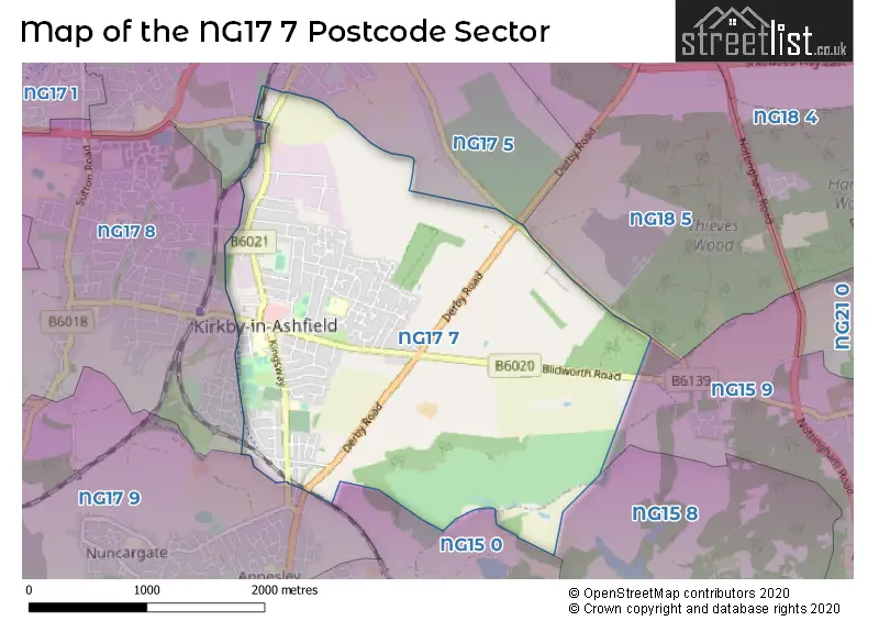
The NG17 7 Postcode shares a border with NG15 0 (Annesley, Newstead Village), NG15 8 (Hucknall, Linby, Papplewick), NG17 5 (SUTTON-IN-ASHFIELD, Maun Valley Industrial Park), NG17 8 (Kirkby-in-Ashfield), NG17 9 (Kirkby-in-Ashfield), NG18 5 (MANSFIELD) and NG15 9 (Ravenshead).
The sector is within the post town of NOTTINGHAM.
NG17 7 is a postcode sector within the NG17 postcode district which is within the NG Nottingham postcode area.
The Royal Mail delivery office for the NG17 7 postal sector is the Kirkby-in-ashfield Delivery Office.
The area of the NG17 7 postcode sector is 3.40 square miles which is 8.79 square kilometres or 2,172.87 square acres.

Map of the NG17 7 Postcode Sector
Explore the NG17 7 postcode sector by using our free interactive map.
| N | G | 1 | 7 | - | 7 | X | X |
| N | G | 1 | 7 | Space | 7 | Letter | Letter |
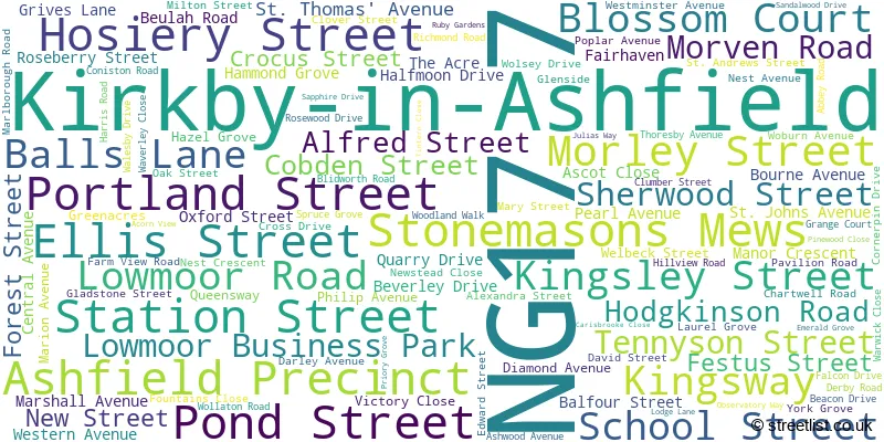
Official List of Streets
Kirkby-in-Ashfield (113 Streets)
Unofficial Streets or Alternative Spellings
Kirkby-in-Ashfield
HORNBEAM WAY NORTH STREET NOTTINGHAM ROAD SOUTHWELL LANE URBAN ROAD BYRON AVENUE FACTORY ROAD HUNT CLOSE LOW MOOR ROAD POST OFFICE ROAD PRECINCT ROAD PROSPECT CLOSE SHELLEY CLOSE SIDINGS ROAD SPRINGFIELD WAY UNITY ROAD WAVERLY CLOSEAnnesley
DERBY ROADSUTTON-IN-ASHFIELD
COXMOOR ROAD KIRKBY FOLLY ROAD MAUN VIEW GARDENS PENNY EMMA WAYWeather Forecast for NG17 7
Press Button to Show Forecast for Kirkby In Ashfield
| Time Period | Icon | Description | Temperature | Rain Probability | Wind |
|---|---|---|---|---|---|
| 09:00 to 12:00 | Cloudy | 5.0°C (feels like 2.0°C) | 8.00% | NNE 9 mph | |
| 12:00 to 15:00 | Overcast | 8.0°C (feels like 5.0°C) | 13.00% | ENE 7 mph | |
| 15:00 to 18:00 | Heavy rain | 6.0°C (feels like 3.0°C) | 83.00% | NE 9 mph | |
| 18:00 to 21:00 | Cloudy | 6.0°C (feels like 3.0°C) | 7.00% | ENE 9 mph | |
| 21:00 to 00:00 | Cloudy | 5.0°C (feels like 3.0°C) | 7.00% | ENE 7 mph |
Press Button to Show Forecast for Kirkby In Ashfield
| Time Period | Icon | Description | Temperature | Rain Probability | Wind |
|---|---|---|---|---|---|
| 00:00 to 03:00 | Cloudy | 4.0°C (feels like 1.0°C) | 5.00% | NE 7 mph | |
| 03:00 to 06:00 | Cloudy | 3.0°C (feels like 0.0°C) | 5.00% | NE 7 mph | |
| 06:00 to 09:00 | Partly cloudy (day) | 3.0°C (feels like 0.0°C) | 3.00% | NNE 9 mph | |
| 09:00 to 12:00 | Cloudy | 7.0°C (feels like 4.0°C) | 10.00% | NE 11 mph | |
| 12:00 to 15:00 | Overcast | 8.0°C (feels like 5.0°C) | 23.00% | ENE 11 mph | |
| 15:00 to 18:00 | Overcast | 8.0°C (feels like 5.0°C) | 23.00% | ENE 11 mph | |
| 18:00 to 21:00 | Cloudy | 7.0°C (feels like 4.0°C) | 12.00% | NE 11 mph | |
| 21:00 to 00:00 | Overcast | 6.0°C (feels like 3.0°C) | 10.00% | NE 11 mph |
Press Button to Show Forecast for Kirkby In Ashfield
| Time Period | Icon | Description | Temperature | Rain Probability | Wind |
|---|---|---|---|---|---|
| 00:00 to 03:00 | Overcast | 5.0°C (feels like 1.0°C) | 12.00% | NNE 13 mph | |
| 03:00 to 06:00 | Light rain | 5.0°C (feels like 1.0°C) | 56.00% | N 13 mph | |
| 06:00 to 09:00 | Heavy rain | 5.0°C (feels like 0.0°C) | 80.00% | N 16 mph | |
| 09:00 to 12:00 | Heavy rain | 5.0°C (feels like 2.0°C) | 82.00% | NNW 13 mph | |
| 12:00 to 15:00 | Light rain | 7.0°C (feels like 4.0°C) | 46.00% | NW 11 mph | |
| 15:00 to 18:00 | Cloudy | 9.0°C (feels like 6.0°C) | 13.00% | WNW 9 mph | |
| 18:00 to 21:00 | Sunny day | 9.0°C (feels like 7.0°C) | 4.00% | W 9 mph | |
| 21:00 to 00:00 | Clear night | 5.0°C (feels like 3.0°C) | 3.00% | WSW 7 mph |
Press Button to Show Forecast for Kirkby In Ashfield
| Time Period | Icon | Description | Temperature | Rain Probability | Wind |
|---|---|---|---|---|---|
| 00:00 to 03:00 | Clear night | 4.0°C (feels like 2.0°C) | 1.00% | SW 7 mph | |
| 03:00 to 06:00 | Clear night | 3.0°C (feels like 0.0°C) | 0.00% | SSW 7 mph | |
| 06:00 to 09:00 | Sunny day | 4.0°C (feels like 2.0°C) | 1.00% | SSW 9 mph | |
| 09:00 to 12:00 | Sunny day | 9.0°C (feels like 7.0°C) | 1.00% | S 11 mph | |
| 12:00 to 15:00 | Cloudy | 12.0°C (feels like 9.0°C) | 6.00% | S 13 mph | |
| 15:00 to 18:00 | Cloudy | 13.0°C (feels like 11.0°C) | 12.00% | S 13 mph | |
| 18:00 to 21:00 | Cloudy | 12.0°C (feels like 10.0°C) | 6.00% | S 11 mph | |
| 21:00 to 00:00 | Clear night | 9.0°C (feels like 7.0°C) | 2.00% | SSE 9 mph |
Press Button to Show Forecast for Kirkby In Ashfield
| Time Period | Icon | Description | Temperature | Rain Probability | Wind |
|---|---|---|---|---|---|
| 00:00 to 03:00 | Clear night | 7.0°C (feels like 5.0°C) | 2.00% | SSE 9 mph | |
| 03:00 to 06:00 | Clear night | 6.0°C (feels like 3.0°C) | 2.00% | SE 9 mph | |
| 06:00 to 09:00 | Sunny day | 7.0°C (feels like 4.0°C) | 3.00% | ESE 9 mph | |
| 09:00 to 12:00 | Partly cloudy (day) | 11.0°C (feels like 9.0°C) | 4.00% | ESE 9 mph | |
| 12:00 to 15:00 | Partly cloudy (day) | 14.0°C (feels like 12.0°C) | 6.00% | ESE 11 mph | |
| 15:00 to 18:00 | Partly cloudy (day) | 15.0°C (feels like 13.0°C) | 7.00% | ESE 11 mph | |
| 18:00 to 21:00 | Partly cloudy (day) | 14.0°C (feels like 12.0°C) | 7.00% | ESE 9 mph | |
| 21:00 to 00:00 | Cloudy | 11.0°C (feels like 9.0°C) | 9.00% | E 9 mph |
Schools and Places of Education Within the NG17 7 Postcode Sector
Morven Park Primary and Nursery School
Community school
School Street, Nottingham, Nottinghamshire, NG17 7BT
Head: Mr Mark Watson
Ofsted Rating: Good
Inspection: 2023-06-15 (316 days ago)
Website: Visit Morven Park Primary and Nursery School Website
Phone: 01623459395
Number of Pupils: 466
Pollyteach Limited
Other independent special school
First Floor Unit, Kirkby in Ashfield, , NG17 7GR
Head: Miss Catherine Brown
Ofsted Rating: Good
Inspection: 2023-06-22 (309 days ago)
Website: Visit Pollyteach Limited Website
Phone: 07383204964
Number of Pupils: 12
House Prices in the NG17 7 Postcode Sector
| Type of Property | 2018 Average | 2018 Sales | 2017 Average | 2017 Sales | 2016 Average | 2016 Sales | 2015 Average | 2015 Sales |
|---|---|---|---|---|---|---|---|---|
| Detached | £207,073 | 31 | £187,455 | 33 | £169,466 | 32 | £174,080 | 25 |
| Semi-Detached | £111,229 | 73 | £104,768 | 57 | £100,447 | 69 | £88,526 | 72 |
| Terraced | £90,134 | 22 | £79,864 | 22 | £79,402 | 23 | £75,291 | 30 |
| Flats | £72,500 | 2 | £66,375 | 5 | £49,650 | 3 | £76,498 | 3 |
Important Postcodes NG17 7 in the Postcode Sector
NG17 7AA is the postcode for Royal Mail, Kirkby-in-Ashfield Delivery Office, Ashfield Precinct
NG17 7AE is the postcode for Ashfield Health Village, Portland Street, REHABILITATION UNIT -, Nottinghamshire County Teaching PCT, Ashfield Community Hospital, NHS PROPERTY SERVICES LTD -, Central Nottinghamshire Healthcare N H S Trust, Portland Street, Nottinghamshire County Teaching PCT, Ashfield Community Hospital, Ashfield Community Hospital, Portland Street, Kirkby-in-Ashfield, and Ashfield Community Hospital, Portland Street
NG17 7AZ is the postcode for Acre Kirkby Young People's Centre, Morley Street
NG17 7BG is the postcode for The Health Care Complex, 52 Lowmoor Road
NG17 7BQ is the postcode for Kirby In Ashfield Library, 23 Ashfield Precinct, and Nottinghamshire County Council, Kirby-in-Ashfield Library, 23 Ashfield Precinct
NG17 7BT is the postcode for BLOCK 2, Morven Park Primary School, School Street, Morven Park Primary School, School Street, and THE CENTRE, Morven Park Primary School, School Street
NG17 7DH is the postcode for LOWER SCHOOL BUILDING, Kirkby College, Tennyson Street, Sports Hall, Kirkby College, Tennyson Street, SPORTS BLOCK, Kirkby College, Tennyson Street, Main School, Kirkby College, Tennyson Street, MAIN SCHOOL BUILDING, Kirkby College, Tennyson Street, and Lower School, Kirkby College, Tennyson Street
NG17 7DJ is the postcode for Festival Hall, Hodgkinson Road
NG17 7FH is the postcode for Kingsway Primary School, Kingsway, Kirkby-in-Ashfield, and Kingsway Primary School, Kingsway
NG17 7FW is the postcode for Kirklands Home, Fairhaven
NG17 7HZ is the postcode for BUILDING 2, The Bracken Hill School, Chartwell Road, The Bracken Hill School, Chartwell Road, Bracken Hill School, Chartwell Road, Kirkby-In-Ashfield, and The Bracken Hill School, Chartwell Road, Kirkby-in-Ashfield
NG17 7LF is the postcode for Whitemeadow, Prospect Close, Lowmoor Business Park
NG17 7LG is the postcode for Kirkby Health Centre, Lowmoor Road
NG17 7NQ is the postcode for Coxmoor Community Centre, Wollaton Road
NG17 7NZ is the postcode for Coxmoor Primary School, Abbey Road, FOUNDATION STAGE, Abbey Hill Primary & Nursery School, Abbey Road, Abbey Hill Primary & Nursery School, Abbey Road, Kirkby-in-Ashfield, and Abbey Hill Primary & Nursery School, Abbey Road
NG17 7RB is the postcode for Vision West Nottinghamshire College, Station Park, Julias Way, Kirkby-in-Ashfield, and Station Park, Julias Way
| The NG17 7 Sector is within these Local Authorities |
|
|---|---|
| The NG17 7 Sector is within these Counties |
|
| The NG17 7 Sector is within these Water Company Areas |
|