The NG22 9 postcode sector is within the county of Nottinghamshire.
Did you know? According to the 2021 Census, the NG22 9 postcode sector is home to a bustling 12,924 residents!
Given that each sector allows for 400 unique postcode combinations. Letters C, I, K, M, O and V are not allowed in the last two letters of a postcode. With 323 postcodes already in use, this leaves 77 units available.
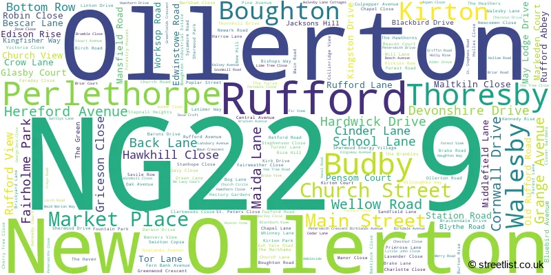
The largest settlement in the NG22 9 postal code is New Ollerton followed by Ollerton, and Boughton.
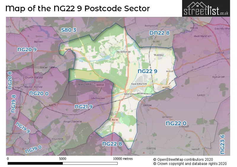
The NG22 9 Postcode shares a border with NG20 0 (Warsop, Church Warsop), NG20 9 (Langwith, Meden Vale, Langwith Junction), DN22 8 (Ranskill, Elkesley, Sutton), NG21 9 (Edwinstowe, Clipstone Village, Kings Clipstone), NG22 0 (Tuxford, East Markham, Wellow), NG22 8 (Bilsthorpe, Farnsfield, Kirklington) and S80 3 (WORKSOP, Rhodesia, Welbeck).
The sector is within the post town of NEWARK.
NG22 9 is a postcode sector within the NG22 postcode district which is within the NG Nottingham postcode area.
The Royal Mail delivery office for the NG22 9 postal sector is the Newark Delivery Office and Walesby Scale Payment Delivery Office.
The area of the NG22 9 postcode sector is 21.35 square miles which is 55.30 square kilometres or 13,663.82 square acres.
Waterways within the NG22 9 postcode sector include the River Maun, Rainworth Water, River Meden.

Map of the NG22 9 Postcode Sector
Explore the NG22 9 postcode sector by using our free interactive map.
| N | G | 2 | 2 | - | 9 | X | X |
| N | G | 2 | 2 | Space | 9 | Letter | Letter |
Official List of Streets
New Ollerton (84 Streets)
Walesby (27 Streets)
Ollerton (46 Streets)
Boughton (30 Streets)
Perlethorpe (3 Streets)
Kirton (14 Streets)
Rufford (5 Streets)
Budby (1 Streets)
Unofficial Streets or Alternative Spellings
Tuxford
OLLERTON ROAD BOGG LANE BOUGHTON WAY BROAD RIDE BUDBY DRIVE CHESTNUT AVENUE COCKING HILL FREEBOARD LANE GOLDEN HILL LANE HAWKHILL LEEN COURT LIME TREE AVENUE MARLIONS TRAIL MEDEN ROAD PETERSMITHS CRESCENT PETERSMITHS DRIVE PIERREPONT BRIDGE PUBLIC FOOT PATH PUMP LANE QUEEN MOTHERS WALK RADLEYS LANE RUFFORD LANE FORD SWINDON COPSE SWINECOTE ROAD THORESBY LANE VEXATION LANE WHITEWATER BRIDGE WHITEWATER LANENew Ollerton
CHURCH CIRCLEBothamsall
MAIN STREETRanby
BLYTH ROADCaunton
NEWARK ROADEdwinstowe
OLLERTON ROAD RUFFORD ROADBilsthorpe
OLD RUFFORD ROADChurch Warsop
NETHERFIELD LANECuckney
BUDBY ROADWeather Forecast for NG22 9
Press Button to Show Forecast for New Ollerton
| Time Period | Icon | Description | Temperature | Rain Probability | Wind |
|---|---|---|---|---|---|
| 15:00 to 18:00 | Cloudy | 21.0°C (feels like 17.0°C) | 4.00% | S 16 mph | |
| 18:00 to 21:00 | Cloudy | 19.0°C (feels like 16.0°C) | 6.00% | S 13 mph | |
| 21:00 to 00:00 | Cloudy | 17.0°C (feels like 15.0°C) | 12.00% | SSE 9 mph |
Press Button to Show Forecast for New Ollerton
| Time Period | Icon | Description | Temperature | Rain Probability | Wind |
|---|---|---|---|---|---|
| 00:00 to 03:00 | Cloudy | 15.0°C (feels like 13.0°C) | 20.00% | SE 9 mph | |
| 03:00 to 06:00 | Light rain | 14.0°C (feels like 13.0°C) | 66.00% | ESE 9 mph | |
| 06:00 to 09:00 | Heavy rain | 14.0°C (feels like 13.0°C) | 92.00% | ESE 9 mph | |
| 09:00 to 12:00 | Heavy rain | 15.0°C (feels like 14.0°C) | 91.00% | ESE 9 mph | |
| 12:00 to 15:00 | Heavy rain | 15.0°C (feels like 14.0°C) | 89.00% | SSE 9 mph | |
| 15:00 to 18:00 | Light rain | 15.0°C (feels like 14.0°C) | 50.00% | SSE 9 mph | |
| 18:00 to 21:00 | Light rain shower (day) | 15.0°C (feels like 14.0°C) | 40.00% | SE 9 mph | |
| 21:00 to 00:00 | Cloudy | 13.0°C (feels like 12.0°C) | 11.00% | SE 7 mph |
Press Button to Show Forecast for New Ollerton
| Time Period | Icon | Description | Temperature | Rain Probability | Wind |
|---|---|---|---|---|---|
| 00:00 to 03:00 | Cloudy | 13.0°C (feels like 12.0°C) | 7.00% | SE 7 mph | |
| 03:00 to 06:00 | Cloudy | 11.0°C (feels like 11.0°C) | 7.00% | ESE 4 mph | |
| 06:00 to 09:00 | Cloudy | 12.0°C (feels like 11.0°C) | 14.00% | ESE 7 mph | |
| 09:00 to 12:00 | Cloudy | 15.0°C (feels like 14.0°C) | 23.00% | ESE 7 mph | |
| 12:00 to 15:00 | Light rain | 17.0°C (feels like 15.0°C) | 47.00% | ESE 7 mph | |
| 15:00 to 18:00 | Light rain shower (day) | 17.0°C (feels like 16.0°C) | 36.00% | ESE 7 mph | |
| 18:00 to 21:00 | Cloudy | 17.0°C (feels like 16.0°C) | 16.00% | ESE 7 mph | |
| 21:00 to 00:00 | Clear night | 13.0°C (feels like 13.0°C) | 2.00% | ESE 4 mph |
Press Button to Show Forecast for New Ollerton
| Time Period | Icon | Description | Temperature | Rain Probability | Wind |
|---|---|---|---|---|---|
| 00:00 to 03:00 | Clear night | 11.0°C (feels like 10.0°C) | 2.00% | ESE 4 mph | |
| 03:00 to 06:00 | Fog | 10.0°C (feels like 9.0°C) | 15.00% | W 2 mph | |
| 06:00 to 09:00 | Fog | 11.0°C (feels like 11.0°C) | 16.00% | WNW 4 mph | |
| 09:00 to 12:00 | Overcast | 16.0°C (feels like 15.0°C) | 12.00% | NNE 4 mph | |
| 12:00 to 15:00 | Cloudy | 18.0°C (feels like 18.0°C) | 11.00% | ENE 4 mph | |
| 15:00 to 18:00 | Light rain | 18.0°C (feels like 17.0°C) | 46.00% | NE 7 mph | |
| 18:00 to 21:00 | Cloudy | 17.0°C (feels like 16.0°C) | 15.00% | N 7 mph | |
| 21:00 to 00:00 | Cloudy | 14.0°C (feels like 13.0°C) | 7.00% | ENE 4 mph |
Press Button to Show Forecast for New Ollerton
| Time Period | Icon | Description | Temperature | Rain Probability | Wind |
|---|---|---|---|---|---|
| 00:00 to 03:00 | Cloudy | 12.0°C (feels like 11.0°C) | 8.00% | NNW 4 mph | |
| 03:00 to 06:00 | Overcast | 11.0°C (feels like 10.0°C) | 12.00% | NNW 4 mph | |
| 06:00 to 09:00 | Overcast | 12.0°C (feels like 11.0°C) | 12.00% | NNW 7 mph | |
| 09:00 to 12:00 | Overcast | 15.0°C (feels like 14.0°C) | 11.00% | NNW 7 mph | |
| 12:00 to 15:00 | Cloudy | 18.0°C (feels like 17.0°C) | 13.00% | NNW 7 mph | |
| 15:00 to 18:00 | Cloudy | 19.0°C (feels like 18.0°C) | 14.00% | N 7 mph | |
| 18:00 to 21:00 | Partly cloudy (day) | 17.0°C (feels like 16.0°C) | 11.00% | NE 9 mph | |
| 21:00 to 00:00 | Overcast | 14.0°C (feels like 13.0°C) | 10.00% | NNE 7 mph |
Schools and Places of Education Within the NG22 9 Postcode Sector
Maun Infant and Nursery School
Community school
Walesby Lane, NEWARK, Nottinghamshire, NG22 9RJ
Head: Miss Kerry Norman
Ofsted Rating: Requires improvement
Inspection: 2022-06-08 (705 days ago)
Website: Visit Maun Infant and Nursery School Website
Phone: 01623860773
Number of Pupils: 200
St Joseph's Catholic Primary and Nursery School
Academy converter
Main Road, Newark, Nottinghamshire, NG22 9JE
Head: Mrs Elspeth Wilkins-Campbell
Ofsted Rating: Good
Inspection: 2023-09-13 (243 days ago)
Website: Visit St Joseph's Catholic Primary and Nursery School Website
Phone: 01623860392
Number of Pupils: 213
The Dukeries Academy
Academy sponsor led
Whinney Lane, Newark, Nottinghamshire, NG22 9TD
Head: Mr Mike Brett
Ofsted Rating: Good
Inspection: 2021-10-13 (943 days ago)
Website: Visit The Dukeries Academy Website
Phone: 01623860545
Number of Pupils: 726
The Forest View Academy
Academy converter
Walesby Lane, Newark, Nottinghamshire, NG22 9RJ
Head: Mrs Ruth Harrison
Ofsted Rating: Good
Inspection: 2023-01-11 (488 days ago)
Website: Visit The Forest View Academy Website
Phone: 01623860365
Number of Pupils: 224
The Parkgate Academy
Academy sponsor led
Whinney Lane, Newark, Nottinghamshire, NG22 9TH
Head: Mr Reece Davy
Ofsted Rating: Good
Inspection: 2019-05-09 (1831 days ago)
Website: Visit The Parkgate Academy Website
Phone: 01623860584
Number of Pupils: 371
Walesby CofE Primary School
Voluntary controlled school
New Hill, Newark, Nottinghamshire, NG22 9PB
Head: Miss S Sampson
Ofsted Rating: Requires improvement
Inspection: 2023-04-19 (390 days ago)
Website: Visit Walesby CofE Primary School Website
Phone: 01623860575
Number of Pupils: 114
House Prices in the NG22 9 Postcode Sector
| Type of Property | 2018 Average | 2018 Sales | 2017 Average | 2017 Sales | 2016 Average | 2016 Sales | 2015 Average | 2015 Sales |
|---|---|---|---|---|---|---|---|---|
| Detached | £240,134 | 87 | £211,511 | 96 | £230,210 | 86 | £192,805 | 62 |
| Semi-Detached | £123,960 | 123 | £111,304 | 131 | £112,721 | 136 | £109,854 | 108 |
| Terraced | £110,490 | 32 | £106,768 | 26 | £101,749 | 29 | £102,426 | 21 |
| Flats | £85,571 | 7 | £75,971 | 7 | £79,294 | 35 | £79,197 | 15 |
Important Postcodes NG22 9 in the Postcode Sector
NG22 9DG is the postcode for CATERING (BLOCK 2), Rufford Country Park, Rufford Road, THE TALBOT SUITE & ANNEXE, Nottinghamshire County Council, The Sawmill, Rufford Lane, THE COACH HOUSE, Rufford Country Park, Rufford Road, Rufford Country Park, Rufford Road, and OFFICE BLOCK (#2), Nottinghamshire County Council, The Sawmill, Rufford Lane
NG22 9FF is the postcode for Bevercotes House, Darwin Drive, Ollerton House, Darwin Drive, Nottinghamshire County Council, Welbeck House, Sherwood Energy Village, Darwin Drive, Nottinghamshire County Council, Welbeck House, Sherwood Energy Village, Darwin Drive, Ollerton, and Welbeck House, Darwin Drive, Sherwood Energy Village
NG22 9GS is the postcode for Thoresby House, Fountain Court, and THORESBY HOUSE, FOUNTAIN COURT, DARWIN DRIVE
NG22 9GW is the postcode for Ollerton House, Darwin Drive
NG22 9HY is the postcode for Bishops Court, Tuxford Road
NG22 9JE is the postcode for Nottinghamshire Fire & Rescue Service, Training Centre, Main Road, St. Josephs Primary School, Main Road, St. JosephG��s Catholic Primary & Nursery School, Main Road, and St. JosephG��s Catholic Primary & Nursery School, Main Road, Boughton
NG22 9JJ is the postcode for Dukeries Leisure Centre, Dukeries Complex, Main Road, and Dukeries Youth Centre, Main Road
NG22 9PB is the postcode for Walesby C of E Primary School, New Hill
NG22 9PL is the postcode for Nottinghamshire County Council, Ollerton Library, Forest Road
NG22 9QA is the postcode for Dukeries Leisure Centre, Whinney Lane
NG22 9QZ is the postcode for Police Station, Forest Road
NG22 9RF is the postcode for Forest View Academy, Walesby Lane, and Forest View, Walesby Lane
NG22 9RJ is the postcode for Maun Infant School, Walesby Lane, and Maun Infant School, Walesby Lane, New Ollerton
NG22 9SZ is the postcode for Central Nottinghamshire Healthcare NHS Trust, Ollerton Health Clinic, Church Circle
NG22 9TD is the postcode for PE BLOCK, Adult & Community Learning, Dukeries Community College, Whinney Lane, SIXTH FORM BLOCK, Adult & Community Learning, Dukeries Community College, Whinney Lane, Ollerton Day Services, Main Road, Boughton, SCIENCE BLOCK, Adult & Community Learning, Dukeries Community College, Whinney Lane, CONSTRUCTION BLOCK, Adult & Community Learning, Dukeries Community College, Whinney Lane, Newark & Sherwood Day Services, Main Road, MAIN SCHOOL BLOCK, Adult & Community Learning, Dukeries Community College, Whinney Lane, CRAFT BLOCK, Adult & Community Learning, Dukeries Community College, Whinney Lane, BUSINESS IT UNIT, Adult & Community Learning, Dukeries Community College, Whinney Lane, and THE ANNEXE, Adult & Community Learning, Dukeries Community College, Whinney Lane
NG22 9TH is the postcode for The Parkgate Academy, Whinney Lane, New Ollerton, Ollerton Primary & Nursery School, Whinney Lane, and The Parkgate Academy, Whinney Lane
| The NG22 9 Sector is within these Local Authorities |
|
|---|---|
| The NG22 9 Sector is within these Counties |
|
| The NG22 9 Sector is within these Water Company Areas |
|
Tourist Attractions within the NG22 9 Postcode Area
We found 1 visitor attractions within the NG22 postcode area
| The Queen's Royal Lancers & Nottinghamshire Yeomanry Musuem |
|---|
| Museums & Art Galleries |
| Museum and / or Art Gallery |
| View The Queen's Royal Lancers & Nottinghamshire Yeomanry Musuem on Google Maps |