The NG4 postcode district is a postal district located in the NG Nottingham postcode area with a population of 40,836 residents according to the 2021 England and Wales Census.
The area of the NG4 postcode district is 7.04 square miles which is 18.22 square kilometres or 4,502.48 acres.
Currently, the NG4 district has about 882 postcode units spread across 4 geographic postcode sectors.
Given that each sector allows for 400 unique postcode combinations, the district has a capacity of 1,600 postcodes. With 882 postcodes already in use, this leaves 718 units available.
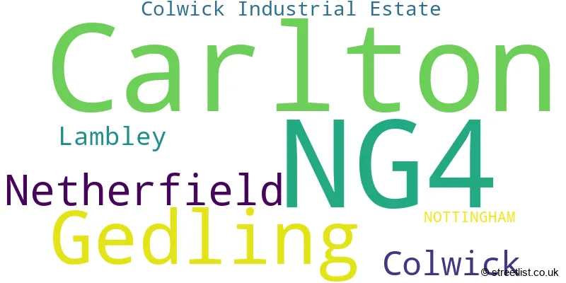
The largest settlement in the NG4 postal code is Carlton followed by Gedling, and Netherfield.
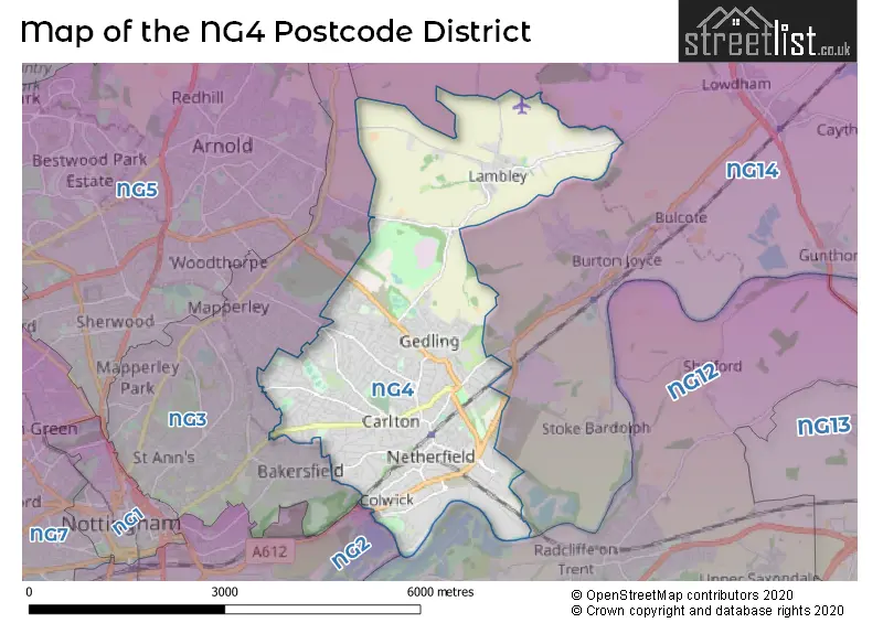
The NG4 Postcode shares a border with NG3 (NOTTINGHAM, Mapperley), NG12 (Radcliffe-on-Trent, Keyworth, Cotgrave) and NG14 (Calverton, Burton Joyce, Lowdham).
The primary settlement in the NG4 postcode district is Carlton, located in Nottinghamshire, England. Other significant settlements include Colwick, Gedling, Netherfield, and Lambley, all within Nottinghamshire. The main post town in the NG4 postcode district is Nottingham.
For the district NG4, we have data on 5 postcode sectors. Here's a breakdown: The sector NG4 1, covers Carlton in Nottinghamshire. The sector NG4 2, covers Netherfield and Colwick and Gedling in Nottinghamshire. The sector NG4 3, covers Carlton and Gedling in Nottinghamshire. The sector NG4 4, covers Gedling and Lambley in Nottinghamshire. The sector NG4 9 is non-geographic. It's often designated for PO Boxes, large organisations, or special services.

Map of the NG4 Postcode District
Explore the NG4 postcode district by using our free interactive map.
When it comes to local government, postal geography often disregards political borders. However, for a breakdown in the NG4 District: the district mostly encompasses the Gedling District (B) area with a total of 905 postcodes.
Recent House Sales in NG4
| Date | Price | Address |
|---|---|---|
| 20/10/2023 | £130,000 | Cavendish Road, Carlton, Nottingham, NG4 3SB |
| 10/10/2023 | £305,000 | Tamarix Close, Gedling, Nottingham, NG4 4AJ |
| 29/09/2023 | £145,000 | Carnarvon Street, Netherfield, Nottingham, NG4 2FL |
| 27/09/2023 | £185,000 | Emerys Road, Gedling, Nottingham, NG4 2QR |
| 26/09/2023 | £177,500 | Third Avenue, Gedling, Nottingham, NG4 3LL |
| 25/09/2023 | £375,000 | Greenhill Road, Carlton, Nottingham, NG4 1DF |
| 22/09/2023 | £120,000 | Colbrook Place, Carlton, Nottingham, NG4 2GH |
| 15/09/2023 | £280,000 | Russet Avenue, Carlton, Nottingham, NG4 3BT |
| 15/09/2023 | £132,000 | Whimsey Park, Carlton, Nottingham, NG4 1DX |
| 15/09/2023 | £160,000 | Tudor Close, Colwick, Nottingham, NG4 2DR |
Weather Forecast for NG4
Press Button to Show Forecast for Carlton (Nottinghamshire)
| Time Period | Icon | Description | Temperature | Rain Probability | Wind |
|---|---|---|---|---|---|
| 09:00 to 12:00 | Cloudy | 8.0°C (feels like 6.0°C) | 15.00% | ENE 9 mph | |
| 12:00 to 15:00 | Overcast | 9.0°C (feels like 7.0°C) | 19.00% | ENE 9 mph | |
| 15:00 to 18:00 | Overcast | 9.0°C (feels like 6.0°C) | 13.00% | ENE 11 mph | |
| 18:00 to 21:00 | Overcast | 8.0°C (feels like 5.0°C) | 11.00% | NE 11 mph | |
| 21:00 to 00:00 | Overcast | 7.0°C (feels like 4.0°C) | 12.00% | NE 9 mph |
Press Button to Show Forecast for Carlton (Nottinghamshire)
| Time Period | Icon | Description | Temperature | Rain Probability | Wind |
|---|---|---|---|---|---|
| 00:00 to 03:00 | Overcast | 6.0°C (feels like 3.0°C) | 13.00% | NNE 11 mph | |
| 03:00 to 06:00 | Heavy rain | 6.0°C (feels like 2.0°C) | 77.00% | N 13 mph | |
| 06:00 to 09:00 | Heavy rain | 6.0°C (feels like 2.0°C) | 84.00% | N 13 mph | |
| 09:00 to 12:00 | Heavy rain | 7.0°C (feels like 3.0°C) | 86.00% | NNW 13 mph | |
| 12:00 to 15:00 | Light rain | 8.0°C (feels like 5.0°C) | 49.00% | NW 11 mph | |
| 15:00 to 18:00 | Overcast | 10.0°C (feels like 8.0°C) | 19.00% | WNW 9 mph | |
| 18:00 to 21:00 | Partly cloudy (day) | 10.0°C (feels like 8.0°C) | 5.00% | W 9 mph | |
| 21:00 to 00:00 | Clear night | 7.0°C (feels like 5.0°C) | 3.00% | SW 7 mph |
Press Button to Show Forecast for Carlton (Nottinghamshire)
| Time Period | Icon | Description | Temperature | Rain Probability | Wind |
|---|---|---|---|---|---|
| 00:00 to 03:00 | Clear night | 5.0°C (feels like 3.0°C) | 1.00% | SW 7 mph | |
| 03:00 to 06:00 | Clear night | 4.0°C (feels like 2.0°C) | 0.00% | SSW 7 mph | |
| 06:00 to 09:00 | Sunny day | 5.0°C (feels like 3.0°C) | 1.00% | SSW 7 mph | |
| 09:00 to 12:00 | Sunny day | 11.0°C (feels like 9.0°C) | 1.00% | SSW 11 mph | |
| 12:00 to 15:00 | Cloudy | 14.0°C (feels like 11.0°C) | 5.00% | S 13 mph | |
| 15:00 to 18:00 | Cloudy | 14.0°C (feels like 11.0°C) | 6.00% | S 13 mph | |
| 18:00 to 21:00 | Partly cloudy (day) | 13.0°C (feels like 11.0°C) | 2.00% | S 9 mph | |
| 21:00 to 00:00 | Clear night | 10.0°C (feels like 8.0°C) | 1.00% | SSE 9 mph |
Press Button to Show Forecast for Carlton (Nottinghamshire)
| Time Period | Icon | Description | Temperature | Rain Probability | Wind |
|---|---|---|---|---|---|
| 00:00 to 03:00 | Clear night | 8.0°C (feels like 6.0°C) | 2.00% | SE 7 mph | |
| 03:00 to 06:00 | Clear night | 6.0°C (feels like 4.0°C) | 2.00% | SE 7 mph | |
| 06:00 to 09:00 | Sunny day | 8.0°C (feels like 6.0°C) | 3.00% | ESE 7 mph | |
| 09:00 to 12:00 | Partly cloudy (day) | 12.0°C (feels like 11.0°C) | 4.00% | ESE 9 mph | |
| 12:00 to 15:00 | Cloudy | 16.0°C (feels like 13.0°C) | 8.00% | SE 11 mph | |
| 15:00 to 18:00 | Cloudy | 16.0°C (feels like 14.0°C) | 8.00% | ESE 11 mph | |
| 18:00 to 21:00 | Partly cloudy (day) | 15.0°C (feels like 13.0°C) | 7.00% | ESE 9 mph | |
| 21:00 to 00:00 | Cloudy | 12.0°C (feels like 10.0°C) | 9.00% | E 7 mph |
Where is the NG4 Postcode District?
The postcode district NG4 is located in Nottingham. It is surrounded by several nearby towns. To the North East is Southwell, which is approximately 7.5 miles away. To the West is Ilkeston, which is approximately 9.6 miles away. To the North West is Mansfield, which is approximately 11.8 miles away. To the South is Loughborough, which is approximately 16.1 miles away. Additionally, NG4 is around 109.6 miles away from the center of London.
The district is within the post town of NOTTINGHAM.
The sector has postcodes within the nation of England.
The NG4 Postcode District is covers the following regions.
- South Nottinghamshire - Derbyshire and Nottinghamshire - East Midlands (England)
- Nottingham - Derbyshire and Nottinghamshire - East Midlands (England)
| Postcode Sector | Delivery Office |
|---|---|
| NG4 1 | Carlton (ng) Delivery Office |
| NG4 2 | Carlton (ng) Delivery Office |
| NG4 3 | Carlton (ng) Delivery Office |
| NG4 4 | Carlton (ng) Delivery Office |
| N | G | 4 | - | X | X | X |
| N | G | 4 | Space | Numeric | Letter | Letter |
Current Monthly Rental Prices
| # Bedrooms | Min Price | Max Price | Avg Price |
|---|---|---|---|
| 1 | £495 | £825 | £603 |
| 2 | £650 | £900 | £792 |
| 3 | £975 | £1,365 | £1,212 |
| 4 | £1,350 | £1,990 | £1,577 |
| 5 | £1,400 | £1,400 | £1,400 |
Current House Prices
| # Bedrooms | Min Price | Max Price | Avg Price |
|---|---|---|---|
| £2,500 | £1,000,000 | £402,083 | |
| 1 | £69,000 | £160,000 | £124,333 |
| 2 | £100,000 | £300,000 | £179,779 |
| 3 | £130,000 | £1,000,000 | £253,855 |
| 4 | £200,000 | £895,000 | £365,896 |
| 5 | £280,000 | £900,000 | £501,500 |
| 6 | £425,000 | £725,000 | £575,000 |
| 7 | £825,000 | £1,250,000 | £1,037,500 |
Estate Agents who Operate in the NG4 District
| Logo | Name | Brand Name | Address | Contact Number | Total Properties |
|---|---|---|---|---|---|
 | Carlton | David James Estate Agents | 317 Carlton Hill, Carlton, Nottingham, NG4 1GL | 0115 647 1168 | 37 |
 | Nottingham | Lesley Greaves Estate Agents | 20 Main Road, Gedling, Nottingham, NG4 3HP | 0115 987 7337 | 34 |
 | Nottingham | HoldenCopley | 26 High Street, Arnold, Nottingham, NG5 7DZ | 0115 647 7831 | 33 |
 | covering Nottingham | Purplebricks | Suite 7 First Floor Cranmore Drive Shirley Solihull B90 4RZ | 020 3908 1066 | 18 |
 | Carlton | Bairstow Eves | 124 Burton Road, Carlton, Nottingham, NG4 3GP | 0115 647 4463 | 16 |
| Type of Property | 2018 Average | 2018 Sales | 2017 Average | 2017 Sales | 2016 Average | 2016 Sales | 2015 Average | 2015 Sales |
|---|---|---|---|---|---|---|---|---|
| Detached | £238,647 | 208 | £221,100 | 200 | £204,245 | 195 | £203,302 | 192 |
| Semi-Detached | £163,748 | 331 | £154,489 | 301 | £139,945 | 276 | £134,153 | 272 |
| Terraced | £126,328 | 195 | £114,195 | 184 | £108,933 | 192 | £104,993 | 189 |
| Flats | £89,710 | 46 | £83,779 | 54 | £79,094 | 47 | £77,005 | 55 |