The NG6 postcode district is a postal district located in the NG Nottingham postcode area with a population of 38,820 residents according to the 2021 England and Wales Census.
The area of the NG6 postcode district is 7.30 square miles which is 18.90 square kilometres or 4,669.22 acres.
Currently, the NG6 district has about 782 postcode units spread across 4 geographic postcode sectors.
Given that each sector allows for 400 unique postcode combinations, the district has a capacity of 1,600 postcodes. With 782 postcodes already in use, this leaves 818 units available.
The largest settlement in the NG6 postal code is NOTTINGHAM followed by Bestwood Village, and Bulwell.
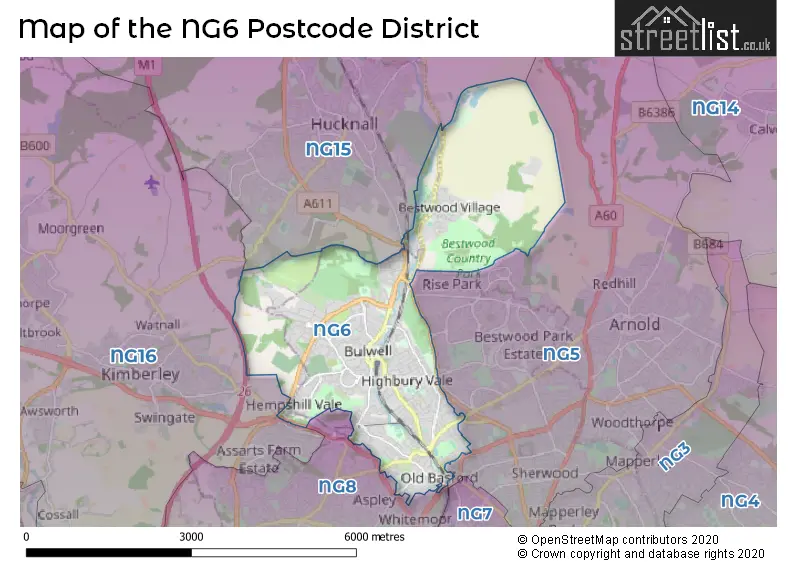
The NG6 Postcode shares a border with NG15 (Hucknall, Ravenshead, Annesley), NG5 (NOTTINGHAM, Arnold, Woodthorpe) and NG8 (NOTTINGHAM, Strelley).
The primary settlement in the NG6 postcode district is Nottingham in the county of Nottinghamshire. Other significant settlements include Old Basford, Stockhill, Bestwood Village, Blenheim Industrial Estate, and Bulwell. The most significant post town is Nottingham in Nottinghamshire.
For the district NG6, we have data on 5 postcode sectors. Here's a breakdown: The sector NG6 0, covers Nottingham in Nottinghamshire. The sector NG6 6 is non-geographic. It's often designated for PO Boxes, large organisations, or special services. The sector NG6 7, covers Nottingham in Nottinghamshire. The sector NG6 8, covers Nottingham and Bestwood Village in Nottinghamshire. The sector NG6 9, covers Nottingham in Nottinghamshire.

Map of the NG6 Postcode District
Explore the NG6 postcode district by using our free interactive map.
When it comes to local government, postal geography often disregards political borders. However, for a breakdown in the NG6 District: the district mostly encompasses the City of Nottingham (B) (715 postcodes), followed by the Gedling District (B) area (49 postcodes), followed by the Ashfield District area (15 postcodes), and finally, the Broxtowe District (B) area (8 postcodes).
Recent House Sales in NG6
| Date | Price | Address |
|---|---|---|
| 29/09/2023 | £223,000 | Sedgebrook Close, Nottingham, NG6 0GP |
| 15/09/2023 | £150,000 | Radley Square, Nottingham, NG6 9DH |
| 15/09/2023 | £137,000 | Brayton Crescent, Nottingham, NG6 9DZ |
| 11/09/2023 | £148,000 | Catherine Close, Bulwell, Nottingham, NG6 8JP |
| 08/09/2023 | £210,000 | Braemar Road, Nottingham, NG6 9HN |
| 06/09/2023 | £248,500 | Ragdale Road, Bulwell, Nottingham, NG6 8GP |
| 01/09/2023 | £100,000 | Merchant Street, Bulwell, Nottingham, NG6 8GU |
| 31/08/2023 | £130,000 | Muriel Street, Bulwell, Nottingham, NG6 8FS |
| 29/08/2023 | £150,000 | Thorner Close, Nottingham, NG6 9EJ |
| 29/08/2023 | £158,000 | Deptford Crescent, Nottingham, NG6 9DP |
Where is the NG6 Postcode District?
The postcode district NG6 is located in the town of Nottingham. It is situated near the towns of Ilkeston (5.75 miles to the South West), Heanor (6.67 miles to the West), Mansfield (8.73 miles to the North), Southwell (9.90 miles to the North East), Alfreton (10.53 miles to the North West), and Newark (12.55 miles to the East). Additionally, the distance from this postcode district to the centre of London is approximately 113.26 miles.
The district is within the post town of NOTTINGHAM.
The sector has postcodes within the nation of England.
The NG6 Postcode District is covers the following regions.
- Nottingham - Derbyshire and Nottinghamshire - East Midlands (England)
- North Nottinghamshire - Derbyshire and Nottinghamshire - East Midlands (England)
- South Nottinghamshire - Derbyshire and Nottinghamshire - East Midlands (England)
Weather Forecast for NG6
Press Button to Show Forecast for Bulwell
| Time Period | Icon | Description | Temperature | Rain Probability | Wind |
|---|---|---|---|---|---|
| 06:00 to 09:00 | Cloudy | 12.0°C (feels like 11.0°C) | 4.00% | NE 7 mph | |
| 09:00 to 12:00 | Partly cloudy (day) | 16.0°C (feels like 15.0°C) | 1.00% | NE 9 mph | |
| 12:00 to 15:00 | Cloudy | 22.0°C (feels like 21.0°C) | 8.00% | E 9 mph | |
| 15:00 to 18:00 | Cloudy | 24.0°C (feels like 22.0°C) | 8.00% | ESE 9 mph | |
| 18:00 to 21:00 | Cloudy | 22.0°C (feels like 20.0°C) | 13.00% | SE 9 mph | |
| 21:00 to 00:00 | Partly cloudy (night) | 18.0°C (feels like 18.0°C) | 10.00% | SE 4 mph |
Press Button to Show Forecast for Bulwell
| Time Period | Icon | Description | Temperature | Rain Probability | Wind |
|---|---|---|---|---|---|
| 00:00 to 03:00 | Clear night | 16.0°C (feels like 16.0°C) | 1.00% | ESE 4 mph | |
| 03:00 to 06:00 | Clear night | 14.0°C (feels like 14.0°C) | 2.00% | SSE 4 mph | |
| 06:00 to 09:00 | Cloudy | 14.0°C (feels like 14.0°C) | 6.00% | S 7 mph | |
| 09:00 to 12:00 | Partly cloudy (day) | 17.0°C (feels like 15.0°C) | 1.00% | SSW 9 mph | |
| 12:00 to 15:00 | Partly cloudy (day) | 20.0°C (feels like 17.0°C) | 1.00% | S 11 mph | |
| 15:00 to 18:00 | Cloudy | 21.0°C (feels like 18.0°C) | 6.00% | S 13 mph | |
| 18:00 to 21:00 | Cloudy | 19.0°C (feels like 17.0°C) | 9.00% | SSE 11 mph | |
| 21:00 to 00:00 | Cloudy | 17.0°C (feels like 15.0°C) | 10.00% | SSE 9 mph |
Press Button to Show Forecast for Bulwell
| Time Period | Icon | Description | Temperature | Rain Probability | Wind |
|---|---|---|---|---|---|
| 00:00 to 03:00 | Cloudy | 15.0°C (feels like 14.0°C) | 21.00% | SE 9 mph | |
| 03:00 to 06:00 | Light rain | 14.0°C (feels like 13.0°C) | 50.00% | ESE 9 mph | |
| 06:00 to 09:00 | Light rain | 14.0°C (feels like 13.0°C) | 56.00% | ESE 9 mph | |
| 09:00 to 12:00 | Heavy rain | 15.0°C (feels like 14.0°C) | 79.00% | ESE 9 mph | |
| 12:00 to 15:00 | Heavy rain | 17.0°C (feels like 15.0°C) | 81.00% | SE 11 mph | |
| 15:00 to 18:00 | Heavy rain shower (day) | 17.0°C (feels like 16.0°C) | 62.00% | SSE 11 mph | |
| 18:00 to 21:00 | Light rain shower (day) | 16.0°C (feels like 15.0°C) | 45.00% | SSE 7 mph | |
| 21:00 to 00:00 | Cloudy | 14.0°C (feels like 14.0°C) | 17.00% | SE 7 mph |
Press Button to Show Forecast for Bulwell
| Time Period | Icon | Description | Temperature | Rain Probability | Wind |
|---|---|---|---|---|---|
| 00:00 to 03:00 | Cloudy | 13.0°C (feels like 12.0°C) | 7.00% | SE 7 mph | |
| 03:00 to 06:00 | Partly cloudy (night) | 12.0°C (feels like 11.0°C) | 4.00% | ESE 4 mph | |
| 06:00 to 09:00 | Cloudy | 13.0°C (feels like 12.0°C) | 8.00% | E 7 mph | |
| 09:00 to 12:00 | Cloudy | 15.0°C (feels like 15.0°C) | 14.00% | ESE 7 mph | |
| 12:00 to 15:00 | Light rain shower (day) | 18.0°C (feels like 17.0°C) | 36.00% | SE 9 mph | |
| 15:00 to 18:00 | Light rain shower (day) | 19.0°C (feels like 17.0°C) | 35.00% | SE 7 mph | |
| 18:00 to 21:00 | Light rain shower (day) | 18.0°C (feels like 17.0°C) | 34.00% | SE 7 mph | |
| 21:00 to 00:00 | Clear night | 15.0°C (feels like 14.0°C) | 4.00% | ESE 4 mph |
Press Button to Show Forecast for Bulwell
| Time Period | Icon | Description | Temperature | Rain Probability | Wind |
|---|---|---|---|---|---|
| 00:00 to 03:00 | Clear night | 13.0°C (feels like 12.0°C) | 3.00% | ESE 4 mph | |
| 03:00 to 06:00 | Clear night | 11.0°C (feels like 11.0°C) | 2.00% | ESE 4 mph | |
| 06:00 to 09:00 | Mist | 13.0°C (feels like 12.0°C) | 14.00% | E 4 mph | |
| 09:00 to 12:00 | Partly cloudy (day) | 16.0°C (feels like 16.0°C) | 3.00% | SSE 4 mph | |
| 12:00 to 15:00 | Cloudy | 19.0°C (feels like 18.0°C) | 11.00% | SSE 4 mph | |
| 15:00 to 18:00 | Cloudy | 20.0°C (feels like 19.0°C) | 13.00% | SSW 7 mph | |
| 18:00 to 21:00 | Partly cloudy (day) | 19.0°C (feels like 18.0°C) | 12.00% | SW 7 mph | |
| 21:00 to 00:00 | Partly cloudy (night) | 16.0°C (feels like 16.0°C) | 9.00% | SW 4 mph |
| Postcode Sector | Delivery Office |
|---|---|
| NG6 0 | Bulwell Delivery Office |
| NG6 7 | Bulwell Delivery Office |
| NG6 8 | Bulwell Delivery Office |
| NG6 9 | Bulwell Delivery Office |
| N | G | 6 | - | X | X | X |
| N | G | 6 | Space | Numeric | Letter | Letter |
Current Monthly Rental Prices
| # Bedrooms | Min Price | Max Price | Avg Price |
|---|---|---|---|
| 1 | £435 | £495 | £465 |
| 2 | £800 | £875 | £844 |
| 3 | £895 | £1,200 | £1,048 |
| 4 | £2,500 | £2,500 | £2,500 |
Current House Prices
| # Bedrooms | Min Price | Max Price | Avg Price |
|---|---|---|---|
| £1 | £725,000 | £275,000 | |
| 1 | £75,000 | £115,000 | £91,667 |
| 2 | £75,000 | £275,000 | £164,282 |
| 3 | £90,000 | £300,000 | £197,113 |
| 4 | £130,000 | £470,000 | £311,364 |
| 5 | £300,000 | £985,000 | £594,983 |
| 7 | £550,000 | £550,000 | £550,000 |
Estate Agents who Operate in the NG6 District
| Logo | Name | Brand Name | Address | Contact Number | Total Properties |
|---|---|---|---|---|---|
 | Hucknall | HoldenCopley | 33A High Street, Hucknall, Nottingham, NG15 7HJ | 0115 647 9661 | 34 |
 | Bulwell | William H. Brown | 263 Main Street, Bulwell, NG6 8EZ | 0115 647 0552 | 26 |
 | Hucknall | Burchell Edwards | 64 High Street, Hucknall, Nottingham, NG15 7AX | 0115 647 6329 | 11 |
 | Hucknall | haart | 34a High Street, Hucknall, Nottingham, NG15 7HG | 0115 647 3690 | 10 |
 | Arnold | Robert Ellis | 78 Front Street, Arnold, Nottingham, NG5 7EJ | 0115 647 6144 | 9 |
Yearly House Price Averages for the NG6 Postcode District
| Type of Property | 2018 Average | 2018 Sales | 2017 Average | 2017 Sales | 2016 Average | 2016 Sales | 2015 Average | 2015 Sales |
|---|---|---|---|---|---|---|---|---|
| Detached | £195,430 | 64 | £171,071 | 91 | £168,731 | 80 | £150,867 | 80 |
| Semi-Detached | £129,758 | 214 | £123,326 | 219 | £117,868 | 229 | £109,925 | 154 |
| Terraced | £103,198 | 253 | £95,969 | 223 | £92,795 | 249 | £82,593 | 230 |
| Flats | £87,200 | 15 | £71,833 | 12 | £71,048 | 20 | £55,545 | 10 |