The NG6 7 postcode sector is within the county of Nottinghamshire.
Did you know? According to the 2021 Census, the NG6 7 postcode sector is home to a bustling 4,472 residents!
Given that each sector allows for 400 unique postcode combinations. Letters C, I, K, M, O and V are not allowed in the last two letters of a postcode. With 79 postcodes already in use, this leaves 321 units available.
The NG6 7 postal code covers the settlement of NOTTINGHAM.
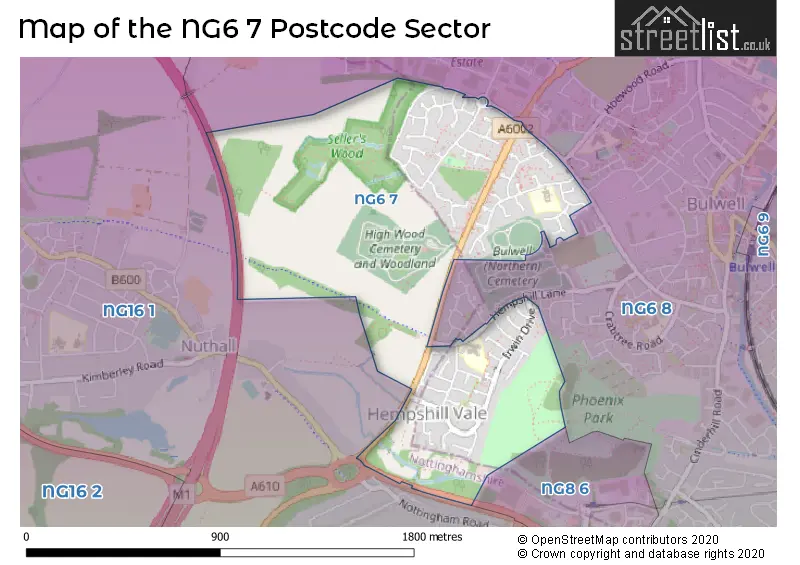
The NG6 7 Postcode shares a border with NG6 8 (NOTTINGHAM, Bestwood Village, Bulwell), NG8 6 (NOTTINGHAM, Strelley) and NG16 1 (Nuthall, Watnall).
The sector is within the post town of NOTTINGHAM.
NG6 7 is a postcode sector within the NG6 postcode district which is within the NG Nottingham postcode area.
The Royal Mail delivery office for the NG6 7 postal sector is the Bulwell Delivery Office.
The area of the NG6 7 postcode sector is 0.74 square miles which is 1.91 square kilometres or 472.78 square acres.
The NG6 7 postcode sector is crossed by the M1 motorway.

Map of the NG6 7 Postcode Sector
Explore the NG6 7 postcode sector by using our free interactive map.
| N | G | 6 | - | 7 | X | X |
| N | G | 6 | Space | 7 | Letter | Letter |
Official List of Streets
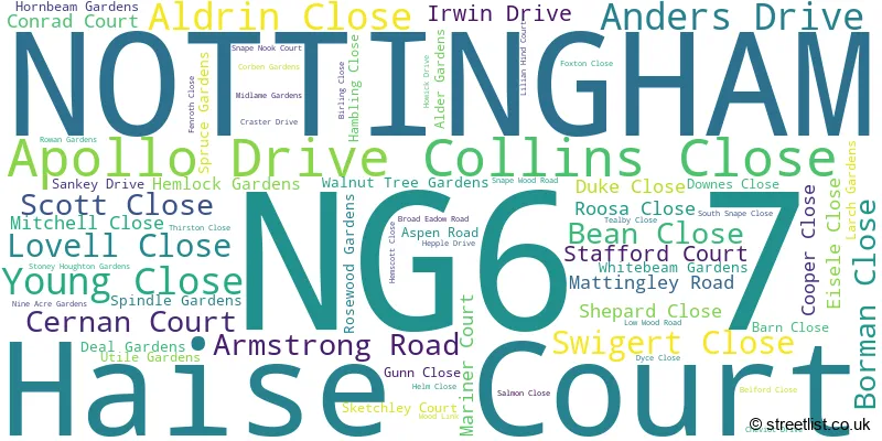
NOTTINGHAM (67 Streets)
Unofficial Streets or Alternative Spellings
NOTTINGHAM
HEMPSHILL LANE HOEWOOD ROAD LILIAN HIND COURT MEADOW RISE SPRINGFIELD DRIVEBulwell
BELGRAVE ROAD DOGWOOD AVENUE FIR CLOSE HARDWOOD CLOSE HEMPSHILL BARNS NUTHALL RAILWAY MULTI-USER ACCESS ROUTE PLANE CLOSE SELLERS WOOD DRIVE SELLERS WOOD DRIVE WEST SOFTWOOD CLOSEBlenheim Industrial Estate
BENNERLEY ROADWeather Forecast for NG6 7
Press Button to Show Forecast for Bulwell
| Time Period | Icon | Description | Temperature | Rain Probability | Wind |
|---|---|---|---|---|---|
| 06:00 to 09:00 | Sunny day | 3.0°C (feels like 0.0°C) | 1.00% | NNE 7 mph | |
| 09:00 to 12:00 | Cloudy | 7.0°C (feels like 5.0°C) | 4.00% | NE 7 mph | |
| 12:00 to 15:00 | Overcast | 9.0°C (feels like 8.0°C) | 9.00% | ENE 4 mph | |
| 15:00 to 18:00 | Cloudy | 10.0°C (feels like 9.0°C) | 8.00% | ENE 4 mph | |
| 18:00 to 21:00 | Cloudy | 8.0°C (feels like 6.0°C) | 11.00% | ENE 9 mph | |
| 21:00 to 00:00 | Cloudy | 6.0°C (feels like 4.0°C) | 10.00% | ENE 7 mph |
Press Button to Show Forecast for Bulwell
| Time Period | Icon | Description | Temperature | Rain Probability | Wind |
|---|---|---|---|---|---|
| 00:00 to 03:00 | Partly cloudy (night) | 4.0°C (feels like 2.0°C) | 8.00% | NE 4 mph | |
| 03:00 to 06:00 | Cloudy | 4.0°C (feels like 1.0°C) | 11.00% | NE 7 mph | |
| 06:00 to 09:00 | Cloudy | 4.0°C (feels like 1.0°C) | 10.00% | NE 7 mph | |
| 09:00 to 12:00 | Cloudy | 8.0°C (feels like 5.0°C) | 12.00% | ENE 9 mph | |
| 12:00 to 15:00 | Cloudy | 9.0°C (feels like 7.0°C) | 18.00% | ENE 9 mph | |
| 15:00 to 18:00 | Cloudy | 11.0°C (feels like 8.0°C) | 19.00% | ENE 11 mph | |
| 18:00 to 21:00 | Cloudy | 9.0°C (feels like 7.0°C) | 19.00% | ENE 11 mph | |
| 21:00 to 00:00 | Cloudy | 7.0°C (feels like 4.0°C) | 15.00% | NE 11 mph |
Press Button to Show Forecast for Bulwell
| Time Period | Icon | Description | Temperature | Rain Probability | Wind |
|---|---|---|---|---|---|
| 00:00 to 03:00 | Overcast | 7.0°C (feels like 4.0°C) | 22.00% | NE 11 mph | |
| 03:00 to 06:00 | Light rain | 7.0°C (feels like 3.0°C) | 52.00% | NNE 13 mph | |
| 06:00 to 09:00 | Heavy rain | 7.0°C (feels like 4.0°C) | 77.00% | NNE 13 mph | |
| 09:00 to 12:00 | Heavy rain | 8.0°C (feels like 5.0°C) | 78.00% | NE 13 mph | |
| 12:00 to 15:00 | Heavy rain | 10.0°C (feels like 7.0°C) | 75.00% | N 13 mph | |
| 15:00 to 18:00 | Light rain shower (day) | 10.0°C (feels like 8.0°C) | 42.00% | N 11 mph | |
| 18:00 to 21:00 | Light rain shower (day) | 10.0°C (feels like 8.0°C) | 38.00% | NNE 9 mph | |
| 21:00 to 00:00 | Cloudy | 8.0°C (feels like 7.0°C) | 11.00% | SW 7 mph |
Schools and Places of Education Within the NG6 7 Postcode Sector
Hempshill Hall Primary School
Community school
Armstrong Road, Nottingham, Nottinghamshire, NG6 7AT
Head: Mrs Sally Dakin
Ofsted Rating: Good
Inspection: 2019-11-06 (1633 days ago)
Website: Visit Hempshill Hall Primary School Website
Phone: 01159153275
Number of Pupils: 430
Snape Wood Primary and Nursery School
Community school
Aspen Road, Nottingham, Nottinghamshire, NG6 7DS
Head: Mrs Shewley Choudhury
Ofsted Rating: Requires improvement
Inspection: 2023-07-04 (297 days ago)
Website: Visit Snape Wood Primary and Nursery School Website
Phone: 01159159146
Number of Pupils: 167
House Prices in the NG6 7 Postcode Sector
| Type of Property | 2018 Average | 2018 Sales | 2017 Average | 2017 Sales | 2016 Average | 2016 Sales | 2015 Average | 2015 Sales |
|---|---|---|---|---|---|---|---|---|
| Detached | £189,500 | 3 | £140,000 | 3 | £154,290 | 5 | £128,590 | 5 |
| Semi-Detached | £142,012 | 35 | £121,966 | 32 | £120,984 | 34 | £112,033 | 29 |
| Terraced | £118,950 | 10 | £85,000 | 15 | £80,584 | 13 | £71,145 | 12 |
| Flats | £39,500 | 2 | £0 | 0 | £48,000 | 2 | £47,667 | 3 |
Important Postcodes NG6 7 in the Postcode Sector
NG6 7AT is the postcode for Hempshill Hall Primary School, Armstrong Road
NG6 7DS is the postcode for Snape Wood Primary School, Aspen Road
NG6 7GH is the postcode for Snape Wood Community Centre, Snape Wood Road
| The NG6 7 Sector is within these Local Authorities |
|
|---|---|
| The NG6 7 Sector is within these Counties |
|
| The NG6 7 Sector is within these Water Company Areas |
|