The NG9 2 postcode sector is within the county of Nottinghamshire.
Did you know? According to the 2021 Census, the NG9 2 postcode sector is home to a bustling 14,607 residents!
Given that each sector allows for 400 unique postcode combinations. Letters C, I, K, M, O and V are not allowed in the last two letters of a postcode. With 275 postcodes already in use, this leaves 125 units available.
The NG9 2 postal code covers the settlement of Beeston.
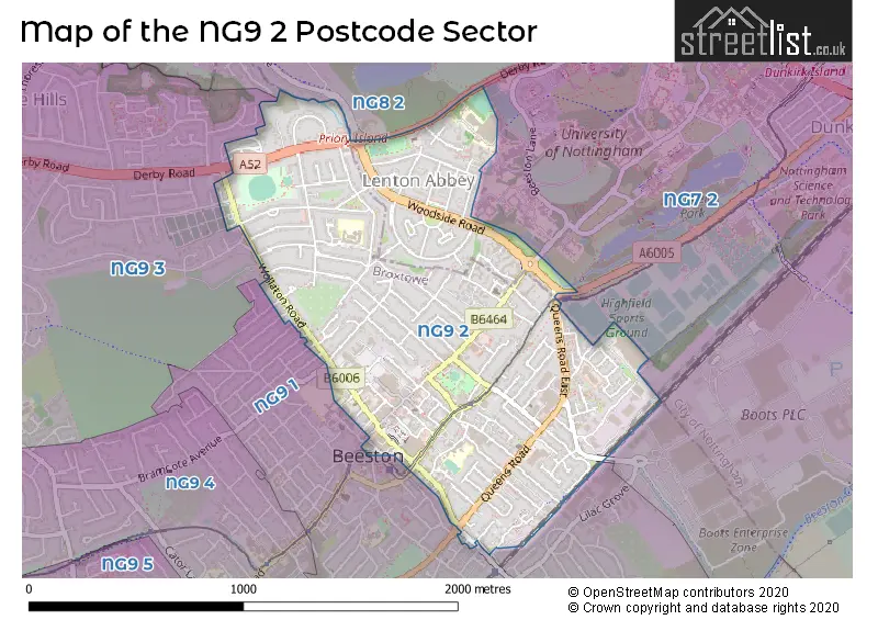
The NG9 2 Postcode shares a border with NG7 2 (NOTTINGHAM, Lenton, Lenton Lane Industrial Estate), NG8 2 (NOTTINGHAM, Wollaton), NG9 1 (Beeston) and NG9 3 (Bramcote, Trowell, Beeston).
The sector is within the post town of NOTTINGHAM.
NG9 2 is a postcode sector within the NG9 postcode district which is within the NG Nottingham postcode area.
The Royal Mail delivery office for the NG9 2 postal sector is the Beeston Delivery Office.
The area of the NG9 2 postcode sector is 0.91 square miles which is 2.35 square kilometres or 580.44 square acres.
The NG9 2 postcode sector is crossed by the A52 Major A road.
Waterways within the NG9 2 postcode sector include the Tottle Brook.

Map of the NG9 2 Postcode Sector
Explore the NG9 2 postcode sector by using our free interactive map.
| N | G | 9 | - | 2 | X | X |
| N | G | 9 | Space | 2 | Letter | Letter |
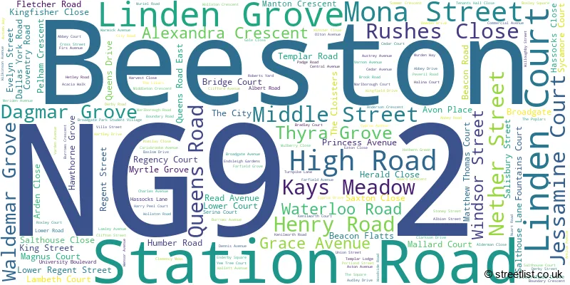
Official List of Streets
Beeston (144 Streets)
Unofficial Streets or Alternative Spellings
Beeston
ABBEY COURT BEESTON FIELDS DRIVE BRADLEY COURT BRAMCOTE DRIVE BRIDGE COURT BROUGHTON STREET CEDAR COURT CHILWELL ROAD CHURCH STREET CLINTON STREET DENISON STREET FELLOWS ROAD GROVE STREET HALINA COURT HARRY PEEL COURT HAWTHORNE GROVE HILLSIDE ROAD JESSAMINE COURT KAYS MEADOW LINDEN COURT MAGNUS COURT MATTHEW THOMAS COURT MIDDLETON STREET REGENCY COURT ROXLEY COURT SIDNEY ROAD STYRING STREET SYCAMORE COURT THE LILACS ABBEY LODGE BROADGATE LANE BROADWOOD COURT GAINSBOROUGH COURT HOFTON COURT HUMBER ROAD SOUTH LACE ROAD LENTON ABBEY LOCAMOTIVE WAY MILL YARD POLLARD COURT PRIORY ISLAND ROSEACRE TEWKESBURY PLACE THE LACE MILL THE NOOKNOTTINGHAM
BEESTON LANEWeather Forecast for NG9 2
Press Button to Show Forecast for Beeston (Nottinghamshire)
| Time Period | Icon | Description | Temperature | Rain Probability | Wind |
|---|---|---|---|---|---|
| 03:00 to 06:00 | Partly cloudy (night) | 3.0°C (feels like 1.0°C) | 1.00% | NNE 4 mph | |
| 06:00 to 09:00 | Partly cloudy (day) | 3.0°C (feels like 1.0°C) | 1.00% | NNE 4 mph | |
| 09:00 to 12:00 | Partly cloudy (day) | 7.0°C (feels like 5.0°C) | 2.00% | NE 7 mph | |
| 12:00 to 15:00 | Cloudy | 9.0°C (feels like 9.0°C) | 8.00% | ENE 4 mph | |
| 15:00 to 18:00 | Cloudy | 10.0°C (feels like 9.0°C) | 8.00% | ENE 4 mph | |
| 18:00 to 21:00 | Cloudy | 8.0°C (feels like 6.0°C) | 11.00% | ENE 9 mph | |
| 21:00 to 00:00 | Cloudy | 6.0°C (feels like 4.0°C) | 10.00% | ENE 7 mph |
Press Button to Show Forecast for Beeston (Nottinghamshire)
| Time Period | Icon | Description | Temperature | Rain Probability | Wind |
|---|---|---|---|---|---|
| 00:00 to 03:00 | Partly cloudy (night) | 5.0°C (feels like 3.0°C) | 8.00% | NE 4 mph | |
| 03:00 to 06:00 | Cloudy | 4.0°C (feels like 2.0°C) | 11.00% | NE 7 mph | |
| 06:00 to 09:00 | Cloudy | 4.0°C (feels like 2.0°C) | 10.00% | NE 7 mph | |
| 09:00 to 12:00 | Cloudy | 8.0°C (feels like 6.0°C) | 12.00% | ENE 9 mph | |
| 12:00 to 15:00 | Cloudy | 10.0°C (feels like 7.0°C) | 18.00% | ENE 9 mph | |
| 15:00 to 18:00 | Overcast | 11.0°C (feels like 9.0°C) | 21.00% | ENE 11 mph | |
| 18:00 to 21:00 | Cloudy | 10.0°C (feels like 7.0°C) | 19.00% | ENE 11 mph | |
| 21:00 to 00:00 | Cloudy | 8.0°C (feels like 5.0°C) | 15.00% | NE 11 mph |
Press Button to Show Forecast for Beeston (Nottinghamshire)
| Time Period | Icon | Description | Temperature | Rain Probability | Wind |
|---|---|---|---|---|---|
| 00:00 to 03:00 | Overcast | 7.0°C (feels like 4.0°C) | 24.00% | NE 11 mph | |
| 03:00 to 06:00 | Light rain | 7.0°C (feels like 4.0°C) | 52.00% | NNE 13 mph | |
| 06:00 to 09:00 | Heavy rain | 7.0°C (feels like 4.0°C) | 77.00% | NNE 13 mph | |
| 09:00 to 12:00 | Heavy rain | 9.0°C (feels like 6.0°C) | 78.00% | NE 13 mph | |
| 12:00 to 15:00 | Heavy rain | 10.0°C (feels like 7.0°C) | 75.00% | N 13 mph | |
| 15:00 to 18:00 | Light rain shower (day) | 10.0°C (feels like 8.0°C) | 42.00% | N 11 mph | |
| 18:00 to 21:00 | Light rain shower (day) | 10.0°C (feels like 8.0°C) | 39.00% | NNE 9 mph | |
| 21:00 to 00:00 | Cloudy | 8.0°C (feels like 7.0°C) | 11.00% | SW 7 mph |
Schools and Places of Education Within the NG9 2 Postcode Sector
Beeston Fields Primary School and Nursery
Academy sponsor led
Boundary Road, Nottingham, Nottinghamshire, NG9 2RG
Head: Angela Huthart
Ofsted Rating: Good
Inspection: 2018-05-17 (2171 days ago)
Website: Visit Beeston Fields Primary School and Nursery Website
Phone: 01158440100
Number of Pupils: 356
House Prices in the NG9 2 Postcode Sector
| Type of Property | 2018 Average | 2018 Sales | 2017 Average | 2017 Sales | 2016 Average | 2016 Sales | 2015 Average | 2015 Sales |
|---|---|---|---|---|---|---|---|---|
| Detached | £293,750 | 22 | £306,073 | 31 | £289,721 | 35 | £348,581 | 24 |
| Semi-Detached | £187,424 | 80 | £196,741 | 95 | £175,558 | 119 | £161,509 | 94 |
| Terraced | £141,812 | 68 | £139,493 | 87 | £132,223 | 78 | £122,483 | 102 |
| Flats | £143,258 | 29 | £145,826 | 42 | £129,371 | 12 | £116,216 | 25 |
Important Postcodes NG9 2 in the Postcode Sector
NG9 2AR is the postcode for Resource Centre, 74 Middle Street
NG9 2AT is the postcode for John Clifford Primary School, Nether Street, and JOHN CLIFFORD PRIMARY SCHOOL, NETHER STREET, BEESTON
NG9 2GQ is the postcode for Nottinghamshire Fire Service, Highfields Fire Station, Hassocks Lane
NG9 2HF is the postcode for Territorial Army, Territorial Army Centre, Broadgate
NG9 2JR is the postcode for Nottinghamshire County Council, Prospect House, 3 Padge Road, Boulevard Industrial Park, Beeston, Prospect House, 3 Padge Road, Boulevard Industrial Park, and Nottinghamshire County Council, Prospect House, 3 Padge Road
NG9 2LW is the postcode for 3 Acacia Walk, Beeston
NG9 2NR is the postcode for Beeston Clinic, Dovecote House, 38 Wollaton Road
NG9 2QP is the postcode for Abbey Medical Centre, 63 Central Avenue
NG9 2RG is the postcode for Surestart Childrens Centre, Boundary Road, Beeston Fields Primary And Nursery School, Boundary Road, and Beeston Fields Primary And Nursery School, Boundary Road, Beeston
NG9 2RR is the postcode for Royal Mail, Nottingham Mail Centre, Padge Road, and Royal Mail, Nottingham RTW, Padge Road
NG9 2WN is the postcode for VARSITY BEESTON, University of Nottingham, Fletcher Road
| The NG9 2 Sector is within these Local Authorities |
|
|---|---|
| The NG9 2 Sector is within these Counties |
|
| The NG9 2 Sector is within these Water Company Areas |
|