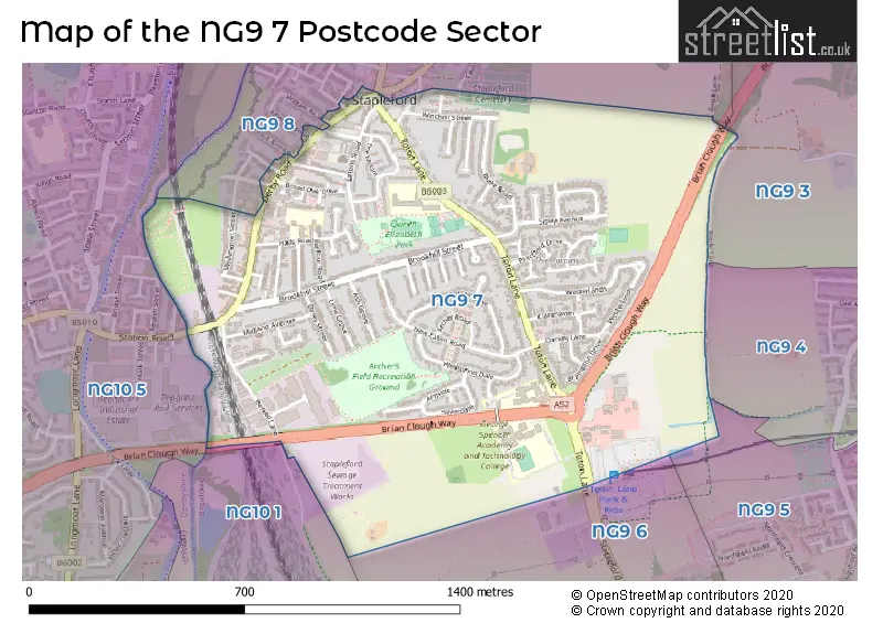
The NG9 7 postcode sector stands on the Derbyshire and Nottinghamshire border.
Did you know? According to the 2021 Census, the NG9 7 postcode sector is home to a bustling 5,871 residents!
Given that each sector allows for 400 unique postcode combinations. Letters C, I, K, M, O and V are not allowed in the last two letters of a postcode. With 117 postcodes already in use, this leaves 283 units available.
The NG9 7 postal code covers the settlement of Stapleford.
The NG9 7 Postcode shares a border with NG9 4 (Beeston), NG9 5 (Beeston, Attenborough), NG10 1 (Long Eaton), NG10 5 (Sandiacre), NG9 3 (Bramcote, Trowell, Beeston), NG9 6 (Toton, Beeston, Attenborough) and NG9 8 (Stapleford).
The sector is within the post town of NOTTINGHAM.
NG9 7 is a postcode sector within the NG9 postcode district which is within the NG Nottingham postcode area.
The Royal Mail delivery office for the NG9 7 postal sector is the Beeston Delivery Office.
The area of the NG9 7 postcode sector is 0.80 square miles which is 2.06 square kilometres or 508.90 square acres.
The NG9 7 postcode sector is crossed by the A52 Major A road.
Waterways within the NG9 7 postcode sector include the River Erewash.

Map of the NG9 7 Postcode Sector
Explore the NG9 7 postcode sector by using our free interactive map.
| N | G | 9 | - | 7 | X | X |
| N | G | 9 | Space | 7 | Letter | Letter |
Official List of Streets
Stapleford (69 Streets)
Unofficial Streets or Alternative Spellings
Bramcote
COMMON LANEStapleford
ALBERT AVENUE ARIA COURT BAULK LANE CHURCH STREET CYRIL AVENUE EATON ROAD HORACE AVENUE NOTTINGHAM ROAD PARK STREET SANDIACRE ROAD TUDOR COURT WARREN AVENUE WILLIAM ROAD BARDILLS ISLAND BESSELL COURT BRIAN CLOUGH WAY FEATHERFIELD PLACE JILL-LAIN COURT ST JAMESS STREET ST JAMESS TERRACE WARREN ARMS PLACESandiacre
STATION ROADWeather Forecast for NG9 7
Press Button to Show Forecast for Stapleford
| Time Period | Icon | Description | Temperature | Rain Probability | Wind |
|---|---|---|---|---|---|
| 09:00 to 12:00 | Overcast | 15.0°C (feels like 13.0°C) | 8.00% | S 11 mph | |
| 12:00 to 15:00 | Cloudy | 19.0°C (feels like 16.0°C) | 4.00% | S 13 mph | |
| 15:00 to 18:00 | Cloudy | 20.0°C (feels like 16.0°C) | 4.00% | S 13 mph | |
| 18:00 to 21:00 | Cloudy | 18.0°C (feels like 15.0°C) | 14.00% | SSE 11 mph | |
| 21:00 to 00:00 | Cloudy | 16.0°C (feels like 14.0°C) | 17.00% | SSE 11 mph |
Press Button to Show Forecast for Stapleford
| Time Period | Icon | Description | Temperature | Rain Probability | Wind |
|---|---|---|---|---|---|
| 00:00 to 03:00 | Light rain | 15.0°C (feels like 14.0°C) | 63.00% | ESE 7 mph | |
| 03:00 to 06:00 | Light rain | 14.0°C (feels like 13.0°C) | 66.00% | ESE 9 mph | |
| 06:00 to 09:00 | Heavy rain | 14.0°C (feels like 13.0°C) | 91.00% | ESE 9 mph | |
| 09:00 to 12:00 | Heavy rain | 15.0°C (feels like 14.0°C) | 91.00% | SE 9 mph | |
| 12:00 to 15:00 | Heavy rain | 15.0°C (feels like 14.0°C) | 84.00% | SSE 9 mph | |
| 15:00 to 18:00 | Light rain | 15.0°C (feels like 14.0°C) | 44.00% | SE 9 mph | |
| 18:00 to 21:00 | Cloudy | 15.0°C (feels like 14.0°C) | 30.00% | SE 9 mph | |
| 21:00 to 00:00 | Cloudy | 14.0°C (feels like 12.0°C) | 8.00% | ESE 7 mph |
Press Button to Show Forecast for Stapleford
| Time Period | Icon | Description | Temperature | Rain Probability | Wind |
|---|---|---|---|---|---|
| 00:00 to 03:00 | Cloudy | 13.0°C (feels like 12.0°C) | 6.00% | ESE 7 mph | |
| 03:00 to 06:00 | Cloudy | 12.0°C (feels like 11.0°C) | 9.00% | ESE 4 mph | |
| 06:00 to 09:00 | Cloudy | 12.0°C (feels like 11.0°C) | 13.00% | E 7 mph | |
| 09:00 to 12:00 | Cloudy | 15.0°C (feels like 14.0°C) | 19.00% | ESE 7 mph | |
| 12:00 to 15:00 | Cloudy | 17.0°C (feels like 16.0°C) | 18.00% | ESE 7 mph | |
| 15:00 to 18:00 | Light rain shower (day) | 18.0°C (feels like 17.0°C) | 34.00% | ESE 7 mph | |
| 18:00 to 21:00 | Light rain shower (day) | 17.0°C (feels like 16.0°C) | 33.00% | ESE 7 mph | |
| 21:00 to 00:00 | Clear night | 14.0°C (feels like 13.0°C) | 5.00% | E 4 mph |
Press Button to Show Forecast for Stapleford
| Time Period | Icon | Description | Temperature | Rain Probability | Wind |
|---|---|---|---|---|---|
| 00:00 to 03:00 | Clear night | 12.0°C (feels like 11.0°C) | 2.00% | E 4 mph | |
| 03:00 to 06:00 | Partly cloudy (night) | 10.0°C (feels like 10.0°C) | 3.00% | ENE 2 mph | |
| 06:00 to 09:00 | Fog | 12.0°C (feels like 11.0°C) | 15.00% | N 4 mph | |
| 09:00 to 12:00 | Partly cloudy (day) | 16.0°C (feels like 15.0°C) | 6.00% | NE 4 mph | |
| 12:00 to 15:00 | Cloudy | 18.0°C (feels like 18.0°C) | 13.00% | E 4 mph | |
| 15:00 to 18:00 | Light rain shower (day) | 18.0°C (feels like 18.0°C) | 36.00% | E 7 mph | |
| 18:00 to 21:00 | Light rain shower (day) | 17.0°C (feels like 16.0°C) | 39.00% | ESE 4 mph | |
| 21:00 to 00:00 | Light rain shower (night) | 15.0°C (feels like 14.0°C) | 31.00% | ENE 4 mph |
Press Button to Show Forecast for Stapleford
| Time Period | Icon | Description | Temperature | Rain Probability | Wind |
|---|---|---|---|---|---|
| 00:00 to 03:00 | Cloudy | 13.0°C (feels like 13.0°C) | 8.00% | WNW 7 mph | |
| 03:00 to 06:00 | Overcast | 12.0°C (feels like 11.0°C) | 12.00% | NW 7 mph | |
| 06:00 to 09:00 | Overcast | 13.0°C (feels like 12.0°C) | 12.00% | NW 7 mph | |
| 09:00 to 12:00 | Overcast | 15.0°C (feels like 15.0°C) | 13.00% | NNW 7 mph | |
| 12:00 to 15:00 | Light rain shower (day) | 18.0°C (feels like 17.0°C) | 33.00% | NNW 7 mph | |
| 15:00 to 18:00 | Light rain shower (day) | 19.0°C (feels like 18.0°C) | 36.00% | NNW 7 mph | |
| 18:00 to 21:00 | Light rain shower (day) | 17.0°C (feels like 16.0°C) | 32.00% | NNW 9 mph | |
| 21:00 to 00:00 | Clear night | 14.0°C (feels like 13.0°C) | 9.00% | NNW 7 mph |
Schools and Places of Education Within the NG9 7 Postcode Sector
Fairfield Spencer Academy
Academy converter
Toton Lane, Nottingham, Nottinghamshire, NG9 7HB
Head: Mrs Shamara Sadler
Ofsted Rating: Good
Inspection: 2021-06-30 (1048 days ago)
Website: Visit Fairfield Spencer Academy Website
Phone: 01159179266
Number of Pupils: 655
George Spencer Academy
Academy converter
Arthur Mee Road, Nottingham, Nottinghamshire, NG9 7EW
Head: Mrs Helen Corbett
Ofsted Rating: Good
Inspection: 2023-03-22 (418 days ago)
Website: Visit George Spencer Academy Website
Phone: 01159170100
Number of Pupils: 1628
William Lilley Infant and Nursery School
Community school
Halls Road, Nottingham, Nottinghamshire, NG9 7FS
Head: Mrs Sally Beardsley
Ofsted Rating: Good
Inspection: 2022-09-29 (592 days ago)
Website: Visit William Lilley Infant and Nursery School Website
Phone: 01159179277
Number of Pupils: 174
House Prices in the NG9 7 Postcode Sector
| Type of Property | 2018 Average | 2018 Sales | 2017 Average | 2017 Sales | 2016 Average | 2016 Sales | 2015 Average | 2015 Sales |
|---|---|---|---|---|---|---|---|---|
| Detached | £210,710 | 31 | £231,920 | 25 | £191,721 | 26 | £228,547 | 29 |
| Semi-Detached | £146,495 | 64 | £142,382 | 61 | £139,260 | 51 | £125,740 | 53 |
| Terraced | £130,281 | 16 | £114,098 | 25 | £109,100 | 44 | £99,391 | 23 |
| Flats | £87,500 | 2 | £71,475 | 2 | £367,386 | 7 | £78,500 | 3 |
Important Postcodes NG9 7 in the Postcode Sector
NG9 7EW is the postcode for UPPER SCHOOL, George Spencer Academy, Arthur Mee Road, 6TH FORM CENTRE, George Spencer Academy, Arthur Mee Road, CLASSROOM BLOCK 18, George Spencer Academy, Arthur Mee Road, 6TH FORM/BUSINESS TRAINING, George Spencer Academy, Arthur Mee Road, SPORTS HALL, George Spencer Academy, Arthur Mee Road, IT SCIENCE, George Spencer Academy, Arthur Mee Road, LANGUAGES, George Spencer Academy, Arthur Mee Road, TEACHING BLOCK 15, George Spencer Academy, Arthur Mee Road, INCLUSION CENTRE, George Spencer Academy, Arthur Mee Road, MATHS & TECHNOLOGY, George Spencer Academy, Arthur Mee Road, and LOWER SCHOOL, George Spencer Academy, Arthur Mee Road
NG9 7FS is the postcode for INFANTS SCHOOL, William Lilley Infant & Nursery School, Halls Road
NG9 7FY is the postcode for DAGFA PARK, University of Nottingham, Dagfa House, THE WOODLANDS 3-4, 5-10, 11-14, University of Nottingham, Dagfa House, THE WOODLANDS 1-2, University of Nottingham, Dagfa House, and DAGFA HOUSE, University of Nottingham, Salthouse Lane
NG9 7HB is the postcode for Fairfield Primary Academy, Toton Lane, and Fairfield Primary Academy, Toton Lane, Stapleford
NG9 7HZ is the postcode for George Spencer Foundation School & Technology College, Toton Lane, LOWER SCHOOL, George Spencer Foundation School & Technology College, Toton Lane, and UPPER SCHOOL BUILDING 2, George Spencer Foundation School & Technology College, Toton Lane
| The NG9 7 Sector is within these Local Authorities |
|
|---|---|
| The NG9 7 Sector is within these Counties |
|
| The NG9 7 Sector is within these Water Company Areas |
|