The NG9 8 postcode sector stands on the Derbyshire and Nottinghamshire border.
Did you know? According to the 2021 Census, the NG9 8 postcode sector is home to a bustling 9,221 residents!
Given that each sector allows for 400 unique postcode combinations. Letters C, I, K, M, O and V are not allowed in the last two letters of a postcode. With 180 postcodes already in use, this leaves 220 units available.
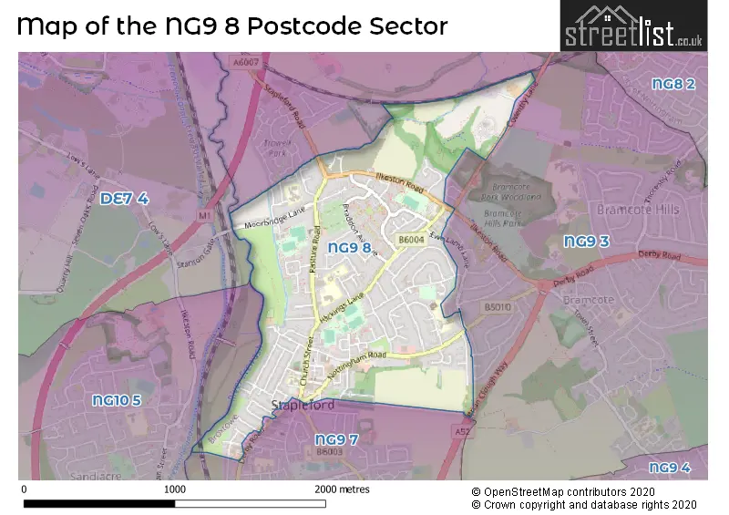
The NG9 8 postal code covers the settlement of Stapleford.
The NG9 8 Postcode shares a border with NG9 7 (Stapleford), NG10 5 (Sandiacre), DE7 4 (ILKESTON, Stanton-by-Dale, Quarry Hill Industrial Estate) and NG9 3 (Bramcote, Trowell, Beeston).
The sector is within the post town of NOTTINGHAM.
NG9 8 is a postcode sector within the NG9 postcode district which is within the NG Nottingham postcode area.
The Royal Mail delivery office for the NG9 8 postal sector is the Beeston Delivery Office.
The area of the NG9 8 postcode sector is 1.03 square miles which is 2.67 square kilometres or 659.47 square acres.
The NG9 8 postcode sector is crossed by the A52 Major A road.
Waterways within the NG9 8 postcode sector include the River Erewash.

Map of the NG9 8 Postcode Sector
Explore the NG9 8 postcode sector by using our free interactive map.
| N | G | 9 | - | 8 | X | X |
| N | G | 9 | Space | 8 | Letter | Letter |
Official List of Streets
Stapleford (124 Streets)
Unofficial Streets or Alternative Spellings
Beeston
DERBY ROADBramcote
COVENTRY LANE EWE LAMB CLOSE EWE LAMB LANE ILKESTON ROADStapleford
DERBY ROAD FARADAY COURT GUTERSLOH COURT PEATFIELD COURT SPRINGFIELD COURT WELLINGTON STREET BRIAN CLOUGH WAY CLIFFE HILL AVENUE FEATHERFIELD PLACE MATTHEWS COURT MOUNT STREET SIDINGS LANE WARREN ARMS PLACE WARREN AVENUE EXTENSION WARREN COURT WESTCROSS AVENUETrowell
STAPLEFORD ROAD TROWELL PARK DRIVEStanton-by-Dale
STANTON GATEWeather Forecast for NG9 8
Press Button to Show Forecast for Stapleford
| Time Period | Icon | Description | Temperature | Rain Probability | Wind |
|---|---|---|---|---|---|
| 09:00 to 12:00 | Partly cloudy (day) | 16.0°C (feels like 15.0°C) | 0.00% | ENE 7 mph | |
| 12:00 to 15:00 | Cloudy | 22.0°C (feels like 20.0°C) | 7.00% | E 9 mph | |
| 15:00 to 18:00 | Cloudy | 23.0°C (feels like 22.0°C) | 9.00% | ESE 9 mph | |
| 18:00 to 21:00 | Cloudy | 22.0°C (feels like 21.0°C) | 14.00% | SSE 9 mph | |
| 21:00 to 00:00 | Cloudy | 18.0°C (feels like 17.0°C) | 16.00% | E 4 mph |
Press Button to Show Forecast for Stapleford
| Time Period | Icon | Description | Temperature | Rain Probability | Wind |
|---|---|---|---|---|---|
| 00:00 to 03:00 | Clear night | 16.0°C (feels like 15.0°C) | 2.00% | SE 4 mph | |
| 03:00 to 06:00 | Clear night | 14.0°C (feels like 14.0°C) | 2.00% | SSE 4 mph | |
| 06:00 to 09:00 | Cloudy | 14.0°C (feels like 14.0°C) | 4.00% | S 7 mph | |
| 09:00 to 12:00 | Cloudy | 17.0°C (feels like 15.0°C) | 4.00% | S 9 mph | |
| 12:00 to 15:00 | Partly cloudy (day) | 19.0°C (feels like 17.0°C) | 2.00% | S 11 mph | |
| 15:00 to 18:00 | Cloudy | 21.0°C (feels like 18.0°C) | 7.00% | S 13 mph | |
| 18:00 to 21:00 | Cloudy | 19.0°C (feels like 16.0°C) | 9.00% | SSE 11 mph | |
| 21:00 to 00:00 | Cloudy | 16.0°C (feels like 15.0°C) | 10.00% | SSE 9 mph |
Press Button to Show Forecast for Stapleford
| Time Period | Icon | Description | Temperature | Rain Probability | Wind |
|---|---|---|---|---|---|
| 00:00 to 03:00 | Cloudy | 15.0°C (feels like 14.0°C) | 15.00% | SE 9 mph | |
| 03:00 to 06:00 | Light rain | 14.0°C (feels like 13.0°C) | 50.00% | ESE 9 mph | |
| 06:00 to 09:00 | Light rain | 14.0°C (feels like 13.0°C) | 56.00% | ESE 9 mph | |
| 09:00 to 12:00 | Heavy rain | 15.0°C (feels like 14.0°C) | 80.00% | ESE 9 mph | |
| 12:00 to 15:00 | Heavy rain | 17.0°C (feels like 15.0°C) | 81.00% | SE 11 mph | |
| 15:00 to 18:00 | Heavy rain shower (day) | 17.0°C (feels like 16.0°C) | 62.00% | SSE 11 mph | |
| 18:00 to 21:00 | Light rain shower (day) | 16.0°C (feels like 15.0°C) | 45.00% | SSE 7 mph | |
| 21:00 to 00:00 | Cloudy | 14.0°C (feels like 13.0°C) | 18.00% | SE 7 mph |
Press Button to Show Forecast for Stapleford
| Time Period | Icon | Description | Temperature | Rain Probability | Wind |
|---|---|---|---|---|---|
| 00:00 to 03:00 | Cloudy | 13.0°C (feels like 12.0°C) | 7.00% | SE 7 mph | |
| 03:00 to 06:00 | Partly cloudy (night) | 12.0°C (feels like 11.0°C) | 4.00% | ESE 4 mph | |
| 06:00 to 09:00 | Cloudy | 13.0°C (feels like 12.0°C) | 8.00% | E 7 mph | |
| 09:00 to 12:00 | Cloudy | 15.0°C (feels like 15.0°C) | 14.00% | ESE 7 mph | |
| 12:00 to 15:00 | Light rain shower (day) | 18.0°C (feels like 17.0°C) | 36.00% | ESE 9 mph | |
| 15:00 to 18:00 | Light rain shower (day) | 18.0°C (feels like 17.0°C) | 35.00% | SE 7 mph | |
| 18:00 to 21:00 | Light rain shower (day) | 18.0°C (feels like 17.0°C) | 33.00% | SE 7 mph | |
| 21:00 to 00:00 | Clear night | 15.0°C (feels like 14.0°C) | 4.00% | ESE 4 mph |
Press Button to Show Forecast for Stapleford
| Time Period | Icon | Description | Temperature | Rain Probability | Wind |
|---|---|---|---|---|---|
| 00:00 to 03:00 | Clear night | 13.0°C (feels like 12.0°C) | 3.00% | ESE 4 mph | |
| 03:00 to 06:00 | Clear night | 11.0°C (feels like 11.0°C) | 2.00% | ESE 4 mph | |
| 06:00 to 09:00 | Mist | 13.0°C (feels like 12.0°C) | 14.00% | E 4 mph | |
| 09:00 to 12:00 | Partly cloudy (day) | 16.0°C (feels like 16.0°C) | 4.00% | SSE 4 mph | |
| 12:00 to 15:00 | Cloudy | 19.0°C (feels like 18.0°C) | 11.00% | SSE 4 mph | |
| 15:00 to 18:00 | Cloudy | 20.0°C (feels like 19.0°C) | 13.00% | SSW 7 mph | |
| 18:00 to 21:00 | Partly cloudy (day) | 19.0°C (feels like 18.0°C) | 11.00% | SW 7 mph | |
| 21:00 to 00:00 | Partly cloudy (night) | 16.0°C (feels like 16.0°C) | 9.00% | SW 4 mph |
Schools and Places of Education Within the NG9 8 Postcode Sector
Albany Infant and Nursery School
Community school
Grenville Drive, Nottingham, Nottinghamshire, NG9 8PD
Head: Ms Kirsten O'Neill
Ofsted Rating: Good
Inspection: 2022-09-22 (598 days ago)
Website: Visit Albany Infant and Nursery School Website
Phone: 01159179212
Number of Pupils: 168
Albany Junior School
Community school
Pasture Road, Nottingham, Nottinghamshire, NG9 8HR
Head: Mrs Laura Goffin
Ofsted Rating: Good
Inspection: 2022-01-19 (844 days ago)
Website: Visit Albany Junior School Website
Phone: 01159176550
Number of Pupils: 190
St John's CofE Primary School
Voluntary controlled school
80 Nottingham Road, Nottingham, Nottinghamshire, NG9 8AQ
Head: Mr Matthew Downes
Ofsted Rating: Good
Inspection: 2019-03-26 (1874 days ago)
Website: Visit St John's CofE Primary School Website
Phone: 01159177111
Number of Pupils: 94
Wadsworth Fields Primary School
Community school
Wadsworth Road, Nottingham, Nottinghamshire, NG9 8BD
Head: Ms Lynn Corner-Brown
Ofsted Rating: Good
Inspection: 2018-02-28 (2265 days ago)
Website: Visit Wadsworth Fields Primary School Website
Phone: 01159496720
Number of Pupils: 295
House Prices in the NG9 8 Postcode Sector
| Type of Property | 2018 Average | 2018 Sales | 2017 Average | 2017 Sales | 2016 Average | 2016 Sales | 2015 Average | 2015 Sales |
|---|---|---|---|---|---|---|---|---|
| Detached | £214,887 | 27 | £225,539 | 22 | £210,942 | 19 | £189,151 | 36 |
| Semi-Detached | £161,232 | 71 | £140,547 | 86 | £134,548 | 64 | £127,501 | 75 |
| Terraced | £120,205 | 42 | £112,489 | 47 | £112,571 | 63 | £101,411 | 62 |
| Flats | £151,189 | 80 | £78,000 | 6 | £787,571 | 14 | £96,600 | 5 |
Important Postcodes NG9 8 in the Postcode Sector
NG9 8AD is the postcode for Central College Nottingham , Whiteley Mill, 39 Nottingham Road
NG9 8AQ is the postcode for St. Johns C of E School, 80 Nottingham Road
NG9 8BD is the postcode for Wadsworth Fields Primary School, Wadsworth Road, and Wadsworth Fields Primary School, Wadsworth Road, Stapleford
NG9 8DA is the postcode for Stapleford Care Centre, Church Street, and Stapleford Care Centre, Church Street, Stapleford
NG9 8GA is the postcode for B Block, Nottingham College, Arthur Mee Centre, Church Street, Central College Nottingham, Arthur Mee Centre, Church Street, A BLOCK, Central College Nottingham, Arthur Mee Centre, Church Street, C BLOCK, Central College Nottingham, Arthur Mee Centre, Church Street, Nottingham College, Arthur Mee Centre - B Block, Church Street, Nottinghamshire County Council, Stapleford Library, Church Street, and B BLOCK, Central College Nottingham, Arthur Mee Centre, Church Street
NG9 8GB is the postcode for Youth Centre, 8 Church Lane
NG9 8GU is the postcode for Clayfields House Secure Unit, 18-20 Moorbridge Lane, Clayfields House, 18-20 Moorbridge Lane, and Clayfields House Secure Unit, 18-20 Moorbridge Lane, Stapleford
NG9 8HR is the postcode for Albany Junior School, Pasture Road, and Albany Junior Mixed School, Pasture Road
NG9 8PB is the postcode for Hickings Lane Pavilion, Hickings Lane Recreation Ground
NG9 8PD is the postcode for Albany Infant & Nursery School, Grenville Drive, Stapleford, Surestart Childrens Centre, 30 Grenville Drive, and Albany Infant & Nursery School, Grenville Drive
| The NG9 8 Sector is within these Local Authorities |
|
|---|---|
| The NG9 8 Sector is within these Counties |
|
| The NG9 8 Sector is within these Water Company Areas |
|