The NN3 5 postcode sector is within the county of Northamptonshire.
Did you know? According to the 2021 Census, the NN3 5 postcode sector is home to a bustling 9,833 residents!
Given that each sector allows for 400 unique postcode combinations. Letters C, I, K, M, O and V are not allowed in the last two letters of a postcode. With 134 postcodes already in use, this leaves 266 units available.
The NN3 5 postal code covers the settlement of NORTHAMPTON.
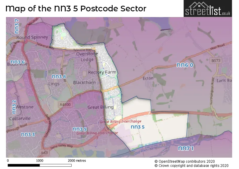
The NN3 5 Postcode shares a border with NN6 0 (Earls Barton, Overstone, Sywell), NN3 8 (NORTHAMPTON, Round Spinney Industrial Estate), NN3 9 (NORTHAMPTON, Little Billing, Great Billing) and NN7 1 (Cogenhoe, Yardley Hastings, Denton).
The sector is within the post town of NORTHAMPTON.
NN3 5 is a postcode sector within the NN3 postcode district which is within the NN Northampton postcode area.
The Royal Mail delivery office for the NN3 5 postal sector is the Northampton East Nn3b Delivery Office.
The area of the NN3 5 postcode sector is 1.74 square miles which is 4.50 square kilometres or 1,112.31 square acres.
The NN3 5 postcode sector is crossed by the A45 Major A road.

Map of the NN3 5 Postcode Sector
Explore the NN3 5 postcode sector by using our free interactive map.
| N | N | 3 | - | 5 | X | X |
| N | N | 3 | Space | 5 | Letter | Letter |
Official List of Streets
NORTHAMPTON (118 Streets)
Unofficial Streets or Alternative Spellings
NORTHAMPTON
BLACKTHORN ROAD SHADOWFAX DRIVE TALAN RISE TALAVERA WAY WELLINGBOROUGH ROADOverstone
BILLING LANELittle Billing
FISHPONDS ROADWeather Forecast for NN3 5
Press Button to Show Forecast for The County Ground Northamptonshire C.C.C.
| Time Period | Icon | Description | Temperature | Rain Probability | Wind |
|---|---|---|---|---|---|
| 21:00 to 00:00 | Cloudy | 7.0°C (feels like 4.0°C) | 5.00% | ENE 9 mph |
Press Button to Show Forecast for The County Ground Northamptonshire C.C.C.
| Time Period | Icon | Description | Temperature | Rain Probability | Wind |
|---|---|---|---|---|---|
| 00:00 to 03:00 | Cloudy | 6.0°C (feels like 3.0°C) | 8.00% | ENE 9 mph | |
| 03:00 to 06:00 | Cloudy | 5.0°C (feels like 2.0°C) | 8.00% | ENE 9 mph | |
| 06:00 to 09:00 | Cloudy | 5.0°C (feels like 2.0°C) | 15.00% | NE 9 mph | |
| 09:00 to 12:00 | Overcast | 7.0°C (feels like 4.0°C) | 48.00% | ENE 11 mph | |
| 12:00 to 15:00 | Overcast | 9.0°C (feels like 6.0°C) | 13.00% | ENE 11 mph | |
| 15:00 to 18:00 | Overcast | 9.0°C (feels like 6.0°C) | 13.00% | ENE 11 mph | |
| 18:00 to 21:00 | Overcast | 8.0°C (feels like 5.0°C) | 11.00% | NE 11 mph | |
| 21:00 to 00:00 | Overcast | 7.0°C (feels like 4.0°C) | 55.00% | NE 11 mph |
Press Button to Show Forecast for The County Ground Northamptonshire C.C.C.
| Time Period | Icon | Description | Temperature | Rain Probability | Wind |
|---|---|---|---|---|---|
| 00:00 to 03:00 | Light rain | 7.0°C (feels like 3.0°C) | 61.00% | NNE 13 mph | |
| 03:00 to 06:00 | Heavy rain | 6.0°C (feels like 3.0°C) | 89.00% | NNE 13 mph | |
| 06:00 to 09:00 | Heavy rain | 6.0°C (feels like 3.0°C) | 93.00% | N 13 mph | |
| 09:00 to 12:00 | Heavy rain | 7.0°C (feels like 3.0°C) | 81.00% | NNW 11 mph | |
| 12:00 to 15:00 | Light rain | 8.0°C (feels like 5.0°C) | 53.00% | NW 11 mph | |
| 15:00 to 18:00 | Overcast | 9.0°C (feels like 7.0°C) | 19.00% | WNW 9 mph | |
| 18:00 to 21:00 | Partly cloudy (day) | 10.0°C (feels like 8.0°C) | 4.00% | WSW 7 mph | |
| 21:00 to 00:00 | Clear night | 7.0°C (feels like 5.0°C) | 2.00% | SW 7 mph |
Press Button to Show Forecast for The County Ground Northamptonshire C.C.C.
| Time Period | Icon | Description | Temperature | Rain Probability | Wind |
|---|---|---|---|---|---|
| 00:00 to 03:00 | Clear night | 6.0°C (feels like 3.0°C) | 1.00% | SW 7 mph | |
| 03:00 to 06:00 | Clear night | 4.0°C (feels like 2.0°C) | 1.00% | SSW 7 mph | |
| 06:00 to 09:00 | Sunny day | 5.0°C (feels like 2.0°C) | 1.00% | S 7 mph | |
| 09:00 to 12:00 | Partly cloudy (day) | 11.0°C (feels like 8.0°C) | 1.00% | S 11 mph | |
| 12:00 to 15:00 | Cloudy | 13.0°C (feels like 11.0°C) | 5.00% | S 13 mph | |
| 15:00 to 18:00 | Cloudy | 14.0°C (feels like 11.0°C) | 6.00% | S 13 mph | |
| 18:00 to 21:00 | Sunny day | 13.0°C (feels like 11.0°C) | 1.00% | S 9 mph | |
| 21:00 to 00:00 | Clear night | 9.0°C (feels like 7.0°C) | 2.00% | SSE 7 mph |
Press Button to Show Forecast for The County Ground Northamptonshire C.C.C.
| Time Period | Icon | Description | Temperature | Rain Probability | Wind |
|---|---|---|---|---|---|
| 00:00 to 03:00 | Clear night | 7.0°C (feels like 5.0°C) | 2.00% | SE 7 mph | |
| 03:00 to 06:00 | Clear night | 7.0°C (feels like 5.0°C) | 2.00% | ESE 7 mph | |
| 06:00 to 09:00 | Sunny day | 8.0°C (feels like 6.0°C) | 3.00% | ESE 7 mph | |
| 09:00 to 12:00 | Partly cloudy (day) | 13.0°C (feels like 11.0°C) | 2.00% | ESE 9 mph | |
| 12:00 to 15:00 | Cloudy | 15.0°C (feels like 13.0°C) | 7.00% | SE 11 mph | |
| 15:00 to 18:00 | Cloudy | 16.0°C (feels like 14.0°C) | 7.00% | SE 11 mph | |
| 18:00 to 21:00 | Partly cloudy (day) | 15.0°C (feels like 13.0°C) | 6.00% | ESE 9 mph | |
| 21:00 to 00:00 | Cloudy | 12.0°C (feels like 10.0°C) | 9.00% | ESE 7 mph |
Schools and Places of Education Within the NN3 5 Postcode Sector
Ecton Brook Primary School
Academy converter
Ecton Brook Road, Northampton, Northamptonshire, NN3 5DY
Head: Debbie Archer Neil Woods
Ofsted Rating: Good
Inspection: 2019-03-06 (1878 days ago)
Website: Visit Ecton Brook Primary School Website
Phone: 01604409608
Number of Pupils: 598
Rectory Farm Primary School
Academy sponsor led
Olden Road, Northampton, Northamptonshire, NN3 5DD
Head: Mrs B Williams
Ofsted Rating: Good
Inspection: 2023-09-20 (219 days ago)
Website: Visit Rectory Farm Primary School Website
Phone: 01604411820
Number of Pupils: 196
St Andrew's Ceva Primary School
Voluntary aided school
Ecton Brook Road, Northampton, Northamptonshire, NN3 5EN
Head: Mrs Val Griffiths
Ofsted Rating: Good
Inspection: 2019-11-20 (1619 days ago)
Website: Visit St Andrew's Ceva Primary School Website
Phone: 01604406486
Number of Pupils: 352
House Prices in the NN3 5 Postcode Sector
| Type of Property | 2018 Average | 2018 Sales | 2017 Average | 2017 Sales | 2016 Average | 2016 Sales | 2015 Average | 2015 Sales |
|---|---|---|---|---|---|---|---|---|
| Detached | £283,865 | 37 | £262,706 | 31 | £232,851 | 53 | £216,045 | 44 |
| Semi-Detached | £178,856 | 40 | £183,589 | 65 | £152,968 | 42 | £140,779 | 39 |
| Terraced | £160,885 | 66 | £165,701 | 62 | £134,478 | 74 | £118,022 | 74 |
| Flats | £92,200 | 5 | £114,250 | 6 | £75,313 | 8 | £60,493 | 7 |
Important Postcodes NN3 5 in the Postcode Sector
NN3 5DD is the postcode for Rectory Farm Primary School, Olden Road
NN3 5DS is the postcode for Southfield EPH, Farmhill Road, Southfields, and Southfields House, Farmhill Road
NN3 5DY is the postcode for Ecton Brook Primary School, Ecton Brook Road
NN3 5EN is the postcode for The Ecton Brook, Ecton Brook Road, Ecton Brook House, Ecton Brook Road, and St. Andrews Church of England Primary School, Ecton Brook Road
NN3 5HW is the postcode for Chedworth House, Chedworth Close
| The NN3 5 Sector is within these Local Authorities |
|
|---|---|
| The NN3 5 Sector is within these Counties |
|
| The NN3 5 Sector is within these Water Company Areas |
|