The NP19 7 postcode sector is within the county of Gwent.
Did you know? According to the 2021 Census, the NP19 7 postcode sector is home to a bustling 13,171 residents!
Given that each sector allows for 400 unique postcode combinations. Letters C, I, K, M, O and V are not allowed in the last two letters of a postcode. With 254 postcodes already in use, this leaves 146 units available.
The NP19 7 postal code covers the settlement of NEWPORT.
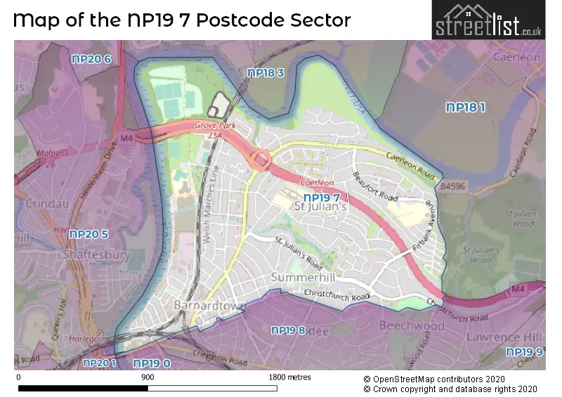
The NP19 7 Postcode shares a border with NP18 1 (CAERLEON, PONTHIR, NEWPORT), NP18 3 (CAERLEON, NEWPORT), NP19 0 (NEWPORT), NP20 1 (NEWPORT), NP19 8 (NEWPORT) and NP20 5 (NEWPORT).
The sector is within the post town of NEWPORT.
NP19 7 is a postcode sector within the NP19 postcode district which is within the NP Newport postcode area.
The Royal Mail delivery office for the NP19 7 postal sector is the Newport East Delivery Office.
The area of the NP19 7 postcode sector is 1.09 square miles which is 2.82 square kilometres or 697.29 square acres.

Map of the NP19 7 Postcode Sector
Explore the NP19 7 postcode sector by using our free interactive map.
| N | P | 1 | 9 | - | 7 | X | X |
| N | P | 1 | 9 | Space | 7 | Letter | Letter |
Official List of Streets
NEWPORT (138 Streets)
Unofficial Streets or Alternative Spellings
NEWPORT
BEECHCROFT ROAD BEECHWOOD ROAD CAMELOT PLACE CLEVEDON ROAD FAIROAK AVENUE HEREFORD STREET PRINCE STREET VICTORIA AVENUE WHITBY PLACE WOODLAND PARK ROAD BANK LANE BARDSY CLOSE CAERLEON INTERCHANGE CONISTON CLOSE DURHAM LANE ENNERDALE COURT FARM LANE HIGH BANKS MARINA COURT OLD BARN ORCHARD COURT ORCHARD LANE POOL LANE RAMSEY CLOSE ST GEORGES CRESCENT THIRLMERE PLACE USK VIEW VAN DYKE CLOSE WILSON ROAD WINDERMERE SQUAREWeather Forecast for NP19 7
Press Button to Show Forecast for Caerleon
| Time Period | Icon | Description | Temperature | Rain Probability | Wind |
|---|---|---|---|---|---|
| 09:00 to 12:00 | Overcast | 6.0°C (feels like 2.0°C) | 10.00% | NNE 9 mph | |
| 12:00 to 15:00 | Cloudy | 8.0°C (feels like 6.0°C) | 8.00% | NE 9 mph | |
| 15:00 to 18:00 | Cloudy | 9.0°C (feels like 7.0°C) | 10.00% | NE 9 mph | |
| 18:00 to 21:00 | Cloudy | 10.0°C (feels like 8.0°C) | 13.00% | NE 7 mph | |
| 21:00 to 00:00 | Cloudy | 8.0°C (feels like 7.0°C) | 15.00% | NE 7 mph |
Press Button to Show Forecast for Caerleon
| Time Period | Icon | Description | Temperature | Rain Probability | Wind |
|---|---|---|---|---|---|
| 00:00 to 03:00 | Light rain | 7.0°C (feels like 5.0°C) | 81.00% | NE 9 mph | |
| 03:00 to 06:00 | Heavy rain | 6.0°C (feels like 3.0°C) | 83.00% | NNE 9 mph | |
| 06:00 to 09:00 | Light rain | 6.0°C (feels like 3.0°C) | 54.00% | NE 11 mph | |
| 09:00 to 12:00 | Light rain | 7.0°C (feels like 3.0°C) | 51.00% | NE 13 mph | |
| 12:00 to 15:00 | Overcast | 8.0°C (feels like 5.0°C) | 18.00% | NE 13 mph | |
| 15:00 to 18:00 | Overcast | 9.0°C (feels like 6.0°C) | 10.00% | NE 13 mph | |
| 18:00 to 21:00 | Overcast | 9.0°C (feels like 6.0°C) | 10.00% | NNE 11 mph | |
| 21:00 to 00:00 | Overcast | 8.0°C (feels like 5.0°C) | 18.00% | NNE 13 mph |
Press Button to Show Forecast for Caerleon
| Time Period | Icon | Description | Temperature | Rain Probability | Wind |
|---|---|---|---|---|---|
| 00:00 to 03:00 | Cloudy | 7.0°C (feels like 4.0°C) | 54.00% | NNE 13 mph | |
| 03:00 to 06:00 | Heavy rain | 6.0°C (feels like 3.0°C) | 75.00% | N 13 mph | |
| 06:00 to 09:00 | Light rain | 6.0°C (feels like 3.0°C) | 58.00% | N 13 mph | |
| 09:00 to 12:00 | Cloudy | 8.0°C (feels like 6.0°C) | 50.00% | NNW 9 mph | |
| 12:00 to 15:00 | Cloudy | 11.0°C (feels like 9.0°C) | 12.00% | NW 9 mph | |
| 15:00 to 18:00 | Cloudy | 12.0°C (feels like 10.0°C) | 8.00% | W 11 mph | |
| 18:00 to 21:00 | Sunny day | 11.0°C (feels like 9.0°C) | 2.00% | WSW 9 mph | |
| 21:00 to 00:00 | Clear night | 8.0°C (feels like 6.0°C) | 0.00% | WSW 7 mph |
Press Button to Show Forecast for Caerleon
| Time Period | Icon | Description | Temperature | Rain Probability | Wind |
|---|---|---|---|---|---|
| 00:00 to 03:00 | Clear night | 7.0°C (feels like 5.0°C) | 1.00% | SW 7 mph | |
| 03:00 to 06:00 | Clear night | 7.0°C (feels like 4.0°C) | 1.00% | S 7 mph | |
| 06:00 to 09:00 | Partly cloudy (day) | 8.0°C (feels like 5.0°C) | 1.00% | S 9 mph | |
| 09:00 to 12:00 | Partly cloudy (day) | 11.0°C (feels like 9.0°C) | 3.00% | S 13 mph | |
| 12:00 to 15:00 | Partly cloudy (day) | 13.0°C (feels like 10.0°C) | 5.00% | S 16 mph | |
| 15:00 to 18:00 | Cloudy | 13.0°C (feels like 10.0°C) | 6.00% | S 16 mph | |
| 18:00 to 21:00 | Partly cloudy (day) | 12.0°C (feels like 10.0°C) | 3.00% | S 13 mph | |
| 21:00 to 00:00 | Partly cloudy (night) | 11.0°C (feels like 8.0°C) | 4.00% | SSE 11 mph |
Press Button to Show Forecast for Caerleon
| Time Period | Icon | Description | Temperature | Rain Probability | Wind |
|---|---|---|---|---|---|
| 00:00 to 03:00 | Cloudy | 10.0°C (feels like 7.0°C) | 6.00% | SE 11 mph | |
| 03:00 to 06:00 | Partly cloudy (night) | 9.0°C (feels like 7.0°C) | 4.00% | SE 11 mph | |
| 06:00 to 09:00 | Partly cloudy (day) | 9.0°C (feels like 7.0°C) | 6.00% | ESE 11 mph | |
| 09:00 to 12:00 | Cloudy | 13.0°C (feels like 10.0°C) | 9.00% | SE 13 mph | |
| 12:00 to 15:00 | Partly cloudy (day) | 14.0°C (feels like 12.0°C) | 8.00% | SE 13 mph | |
| 15:00 to 18:00 | Cloudy | 14.0°C (feels like 12.0°C) | 12.00% | SSE 13 mph | |
| 18:00 to 21:00 | Cloudy | 14.0°C (feels like 12.0°C) | 10.00% | SE 9 mph | |
| 21:00 to 00:00 | Clear night | 11.0°C (feels like 10.0°C) | 5.00% | SE 7 mph |
House Prices in the NP19 7 Postcode Sector
| Type of Property | 2018 Average | 2018 Sales | 2017 Average | 2017 Sales | 2016 Average | 2016 Sales | 2015 Average | 2015 Sales |
|---|---|---|---|---|---|---|---|---|
| Detached | £247,333 | 9 | £257,095 | 10 | £235,200 | 10 | £188,786 | 7 |
| Semi-Detached | £171,837 | 68 | £161,374 | 73 | £154,078 | 57 | £148,169 | 64 |
| Terraced | £134,051 | 152 | £117,128 | 154 | £106,932 | 122 | £102,208 | 109 |
| Flats | £109,611 | 18 | £69,319 | 8 | £73,119 | 8 | £60,375 | 10 |
Important Postcodes NP19 7 in the Postcode Sector
NP19 7AA is the postcode for Newport (Gwent) Civil & Family Court, Clarence House, Clarence Place
NP19 7HF is the postcode for Glan Usk Primary School, Bank Street
NP19 7JZ is the postcode for ROSLA BUILDING, St. Julians Comprehensive School, Heather Road, JUBILEE BUILDING, St. Julians Comprehensive School, Heather Road, and MAIN BUILDING, St. Julians Comprehensive School, Heather Road
NP19 7UB is the postcode for St. Julians Junior & Infants School, Beaufort Road
| The NP19 7 Sector is within these Local Authorities |
|
|---|---|
| The NP19 7 Sector is within these Counties |
|
| The NP19 7 Sector is within these Water Company Areas |
|