The NP44 4 postcode sector is within the county of Gwent.
Did you know? According to the 2021 Census, the NP44 4 postcode sector is home to a bustling 6,913 residents!
Given that each sector allows for 400 unique postcode combinations. Letters C, I, K, M, O and V are not allowed in the last two letters of a postcode. With 170 postcodes already in use, this leaves 230 units available.
The largest settlement in the NP44 4 postal code is Fairwater followed by GREENMEADOW, and St. Dials.
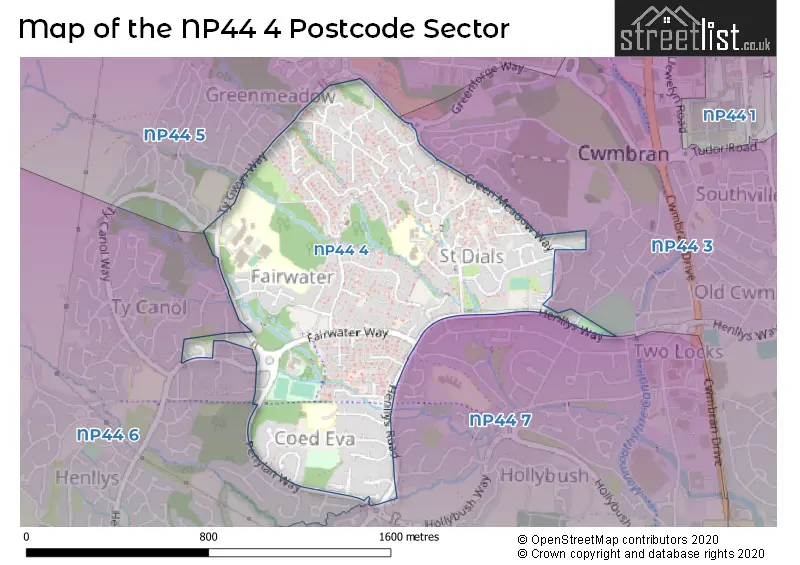
The NP44 4 Postcode shares a border with NP44 3 (LLANTARNAM, CWMBRAN, Oakfield), NP44 5 (Thornhill, UPPER CWMBRAN, GREENMEADOW), NP44 6 (HENLLYS, Ty Canol, Coed Eva) and NP44 7 (COED EVA, HOLLYBUSH, TWO LOCKS).
The sector is within the post town of CWMBRAN.
NP44 4 is a postcode sector within the NP44 postcode district which is within the NP Newport postcode area.
The Royal Mail delivery office for the NP44 4 postal sector is the Cwmbran Delivery Office.
The area of the NP44 4 postcode sector is 0.61 square miles which is 1.59 square kilometres or 393.32 square acres.

Map of the NP44 4 Postcode Sector
Explore the NP44 4 postcode sector by using our free interactive map.
| N | P | 4 | 4 | - | 4 | X | X |
| N | P | 4 | 4 | Space | 4 | Letter | Letter |
Official List of Streets
St. Dials (33 Streets)
Greenmeadow (26 Streets)
Fairwater (51 Streets)
Coed Eva (9 Streets)
Unofficial Streets or Alternative Spellings
CWMBRAN
COCKER AVENUE CWRT Y GAMLAS HEOL Y GROES KEATS CLOSE TON ROAD WAUN ROAD WESLEY STREET ARCHER ROAD BYWAYS COURT F CROFTEN MEDE CWRT PENYLAN DEERBROOK EARLSMEAD FFORDD THORNCLIFFE GILSTON COURT GLAN RHYD GREENMEADOW CLOSE HENLLYS ROAD JULE ROAD MASRTON PATH MOSS ROAD PACE ROAD PEN-Y-WAUN CLOSE PEN-Y-WAUN ROAD PENYLAN WAY RAVENSCOURT REDE ROAD SELWYNS TY GWYN BUNGALOWS TY GWYN WAY TY-CANOL ROW WOOLPITCHSt. Dials
CWRT CELYNCoed Eva
FARLAYS NEERINGS OAKSFORD STEVELEEFairwater
KINGSLEAGreenmeadow
CANBERRA CLOSE MARLBOROUGH ROAD MELBOURNE COURT SALISBURY COURTHenllys
TY CANOL WAYTy Canol
ORCHID COURTWeather Forecast for NP44 4
Press Button to Show Forecast for Cwmbran
| Time Period | Icon | Description | Temperature | Rain Probability | Wind |
|---|---|---|---|---|---|
| 00:00 to 03:00 | Cloudy | 7.0°C (feels like 5.0°C) | 5.00% | NNE 4 mph | |
| 03:00 to 06:00 | Cloudy | 6.0°C (feels like 4.0°C) | 5.00% | NE 4 mph | |
| 06:00 to 09:00 | Cloudy | 6.0°C (feels like 3.0°C) | 6.00% | NE 7 mph | |
| 09:00 to 12:00 | Cloudy | 8.0°C (feels like 5.0°C) | 9.00% | E 9 mph | |
| 12:00 to 15:00 | Overcast | 10.0°C (feels like 8.0°C) | 14.00% | E 7 mph | |
| 15:00 to 18:00 | Overcast | 10.0°C (feels like 9.0°C) | 15.00% | ENE 7 mph | |
| 18:00 to 21:00 | Cloudy | 10.0°C (feels like 8.0°C) | 16.00% | ENE 7 mph | |
| 21:00 to 00:00 | Cloudy | 8.0°C (feels like 6.0°C) | 14.00% | ENE 7 mph |
Press Button to Show Forecast for Cwmbran
| Time Period | Icon | Description | Temperature | Rain Probability | Wind |
|---|---|---|---|---|---|
| 00:00 to 03:00 | Cloudy | 6.0°C (feels like 4.0°C) | 15.00% | ENE 7 mph | |
| 03:00 to 06:00 | Cloudy | 5.0°C (feels like 3.0°C) | 14.00% | NE 7 mph | |
| 06:00 to 09:00 | Cloudy | 5.0°C (feels like 2.0°C) | 13.00% | NE 9 mph | |
| 09:00 to 12:00 | Light rain | 7.0°C (feels like 4.0°C) | 52.00% | NE 11 mph | |
| 12:00 to 15:00 | Overcast | 10.0°C (feels like 7.0°C) | 22.00% | NE 11 mph | |
| 15:00 to 18:00 | Overcast | 11.0°C (feels like 9.0°C) | 21.00% | ENE 11 mph | |
| 18:00 to 21:00 | Overcast | 11.0°C (feels like 8.0°C) | 24.00% | NE 11 mph | |
| 21:00 to 00:00 | Light rain | 9.0°C (feels like 6.0°C) | 51.00% | NE 11 mph |
Press Button to Show Forecast for Cwmbran
| Time Period | Icon | Description | Temperature | Rain Probability | Wind |
|---|---|---|---|---|---|
| 00:00 to 03:00 | Light rain | 8.0°C (feels like 4.0°C) | 53.00% | NE 13 mph | |
| 03:00 to 06:00 | Heavy rain | 7.0°C (feels like 4.0°C) | 73.00% | NNE 11 mph | |
| 06:00 to 09:00 | Heavy rain | 7.0°C (feels like 4.0°C) | 75.00% | NNE 13 mph | |
| 09:00 to 12:00 | Heavy rain | 8.0°C (feels like 5.0°C) | 70.00% | NNE 13 mph | |
| 12:00 to 15:00 | Light rain shower (day) | 10.0°C (feels like 7.0°C) | 43.00% | WNW 13 mph | |
| 15:00 to 18:00 | Light rain | 11.0°C (feels like 9.0°C) | 49.00% | NW 11 mph | |
| 18:00 to 21:00 | Cloudy | 11.0°C (feels like 10.0°C) | 14.00% | NNW 7 mph | |
| 21:00 to 00:00 | Clear night | 9.0°C (feels like 8.0°C) | 6.00% | W 4 mph |
House Prices in the NP44 4 Postcode Sector
| Type of Property | 2018 Average | 2018 Sales | 2017 Average | 2017 Sales | 2016 Average | 2016 Sales | 2015 Average | 2015 Sales |
|---|---|---|---|---|---|---|---|---|
| Detached | £196,500 | 4 | £199,000 | 8 | £182,563 | 4 | £169,200 | 5 |
| Semi-Detached | £136,000 | 10 | £99,401 | 14 | £124,180 | 15 | £109,395 | 10 |
| Terraced | £110,932 | 71 | £99,028 | 55 | £101,588 | 43 | £92,612 | 38 |
| Flats | £65,500 | 2 | £72,333 | 3 | £51,375 | 4 | £0 | 0 |
Important Postcodes NP44 4 in the Postcode Sector
NP44 4HB is the postcode for Ysgol Gymraeg Cwmbran, Henllys Way
NP44 4SY is the postcode for The Powerstation, Blenheim Road, and The Power Station, Blenheim Road, St Dials
NP44 4SZ is the postcode for JUNIOR BUILDING BLENHEIM ROAD PRIMARY SCHOOL, Blenheim Road School, Blenheim Road, Blenheim Road School, Blenheim Road, Blenheim Road Community Primary School, Blenheim Road, and INFANTS & NURSERY BLENHEIM ROAD PRIMARY SCHOOL, Blenheim Road School, Blenheim Road
NP44 4TG is the postcode for COED EVA INFANT BUILDING COED EVA JUNIOR & INFANT SCHOOL, Coed Eva Junior & Infant School, Teynes, Coed Eva Primary School, Teynes, Coed Eva, INFANT BUILDING, Coed Eva Junior & Infant School, Teynes, COED EVA JUNIOR BUILDING COED EVA JUNIOR & INFANT SCHOOL, Coed Eva Junior & Infant School, Teynes, and JUNIOR BUILDING, Coed Eva Junior & Infant School, Teynes
NP44 4YZ is the postcode for Torfaen County Borough Council, Fairwater Leisure Centre, Ty-Gwyn Way, SCIENCE BLOCK SCIENCE BLOCK, Fairwater High School, Ty-Gwyn Way, UPPER SCHOOL, Fairwater High School, Ty-Gwyn Way, TECHNOLOGY BLDG, Cwmbran High School, Ty-Gwyn Way, UPPER SCHOOL, Cwmbran High School, Ty-Gwyn Way, SCIENCE BLOCK, Cwmbran High School, Ty-Gwyn Way, LOWER SCHOOL, Fairwater High School, Ty-Gwyn Way, and LOWER SCHOOL, Cwmbran High School, Ty-Gwyn Way
| The NP44 4 Sector is within these Local Authorities |
|
|---|---|
| The NP44 4 Sector is within these Counties |
|
| The NP44 4 Sector is within these Water Company Areas |
|