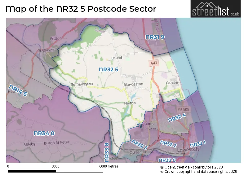
The NR32 5 postcode sector stands on the Norfolk and Suffolk border.
Did you know? According to the 2021 Census, the NR32 5 postcode sector is home to a bustling 3,692 residents!
Given that each sector allows for 400 unique postcode combinations. Letters C, I, K, M, O and V are not allowed in the last two letters of a postcode. With 153 postcodes already in use, this leaves 247 units available.
The largest settlement in the NR32 5 postal code is Corton followed by Blundeston, and Lound.
The NR32 5 Postcode shares a border with NR32 3 (LOWESTOFT, Oulton), NR32 4 (LOWESTOFT), NR33 8 (Carlton Colville, LOWESTOFT, Gisleham), NR34 0 (Gillingham, Aldeby, Toft Monks) and NR31 9 (Belton, Bradwell, Hopton).
The sector is within the post town of LOWESTOFT.
NR32 5 is a postcode sector within the NR3 postcode district which is within the NR Norwich postcode area.
The Royal Mail delivery office for the NR32 5 postal sector is the unknown.
The area of the NR32 5 postcode sector is 13.84 square miles which is 35.84 square kilometres or 8,856.43 square acres.
The NR32 5 postcode sector is crossed by the A12 Major A road.
Waterways within the NR32 5 postcode sector include the Oulton Dyke, River Waveney.

Map of the NR32 5 Postcode Sector
Explore the NR32 5 postcode sector by using our free interactive map.
| N | R | 3 | 2 | - | 5 | X | X |
| N | R | 3 | 2 | Space | 5 | Letter | Letter |
Official List of Streets
Lound (13 Streets)
Corton (25 Streets)
Blundeston (25 Streets)
Somerleyton (15 Streets)
Ashby (1 Streets)
Herringfleet (2 Streets)
Oulton (7 Streets)
LOWESTOFT (7 Streets)
Unofficial Streets or Alternative Spellings
LOWESTOFT
CORTON ROAD DUNSTON DRIVE MILLENNIUM WAYOulton
LIME AVENUE SANDS LANE UNION LANEHopton
DORKING ROAD HALL ROADBradwell
BROWSTON LANESt. Olaves
HERRINGFLEET ROADWeather Forecast for NR32 5
Press Button to Show Forecast for Somerleyton Hall & Gardens
| Time Period | Icon | Description | Temperature | Rain Probability | Wind |
|---|---|---|---|---|---|
| 06:00 to 09:00 | Sunny day | 7.0°C (feels like 4.0°C) | 0.00% | SSW 11 mph | |
| 09:00 to 12:00 | Partly cloudy (day) | 12.0°C (feels like 10.0°C) | 3.00% | SSW 16 mph | |
| 12:00 to 15:00 | Sunny day | 14.0°C (feels like 10.0°C) | 0.00% | S 18 mph | |
| 15:00 to 18:00 | Sunny day | 14.0°C (feels like 11.0°C) | 0.00% | S 18 mph | |
| 18:00 to 21:00 | Sunny day | 12.0°C (feels like 10.0°C) | 0.00% | S 13 mph | |
| 21:00 to 00:00 | Clear night | 9.0°C (feels like 7.0°C) | 0.00% | SSE 9 mph |
Press Button to Show Forecast for Somerleyton Hall & Gardens
| Time Period | Icon | Description | Temperature | Rain Probability | Wind |
|---|---|---|---|---|---|
| 00:00 to 03:00 | Clear night | 8.0°C (feels like 6.0°C) | 0.00% | SSE 7 mph | |
| 03:00 to 06:00 | Clear night | 8.0°C (feels like 6.0°C) | 0.00% | SE 7 mph | |
| 06:00 to 09:00 | Sunny day | 11.0°C (feels like 9.0°C) | 0.00% | SE 9 mph | |
| 09:00 to 12:00 | Cloudy | 14.0°C (feels like 12.0°C) | 4.00% | SE 11 mph | |
| 12:00 to 15:00 | Cloudy | 15.0°C (feels like 12.0°C) | 6.00% | SE 11 mph | |
| 15:00 to 18:00 | Cloudy | 15.0°C (feels like 13.0°C) | 7.00% | SE 11 mph | |
| 18:00 to 21:00 | Cloudy | 13.0°C (feels like 12.0°C) | 8.00% | SE 9 mph | |
| 21:00 to 00:00 | Light rain shower (night) | 12.0°C (feels like 10.0°C) | 41.00% | SE 7 mph |
Press Button to Show Forecast for Somerleyton Hall & Gardens
| Time Period | Icon | Description | Temperature | Rain Probability | Wind |
|---|---|---|---|---|---|
| 00:00 to 03:00 | Cloudy | 11.0°C (feels like 10.0°C) | 16.00% | SE 4 mph | |
| 03:00 to 06:00 | Cloudy | 9.0°C (feels like 8.0°C) | 17.00% | SE 4 mph | |
| 06:00 to 09:00 | Mist | 10.0°C (feels like 10.0°C) | 19.00% | ENE 4 mph | |
| 09:00 to 12:00 | Cloudy | 14.0°C (feels like 14.0°C) | 9.00% | E 4 mph | |
| 12:00 to 15:00 | Cloudy | 16.0°C (feels like 15.0°C) | 7.00% | NE 7 mph | |
| 15:00 to 18:00 | Cloudy | 14.0°C (feels like 13.0°C) | 6.00% | NNE 9 mph | |
| 18:00 to 21:00 | Cloudy | 12.0°C (feels like 10.0°C) | 7.00% | N 9 mph | |
| 21:00 to 00:00 | Cloudy | 11.0°C (feels like 9.0°C) | 11.00% | N 11 mph |
Press Button to Show Forecast for Somerleyton Hall & Gardens
| Time Period | Icon | Description | Temperature | Rain Probability | Wind |
|---|---|---|---|---|---|
| 00:00 to 03:00 | Cloudy | 10.0°C (feels like 8.0°C) | 11.00% | NNW 11 mph | |
| 03:00 to 06:00 | Cloudy | 10.0°C (feels like 8.0°C) | 7.00% | NNW 11 mph | |
| 06:00 to 09:00 | Cloudy | 11.0°C (feels like 9.0°C) | 7.00% | NNW 11 mph | |
| 09:00 to 12:00 | Cloudy | 13.0°C (feels like 11.0°C) | 6.00% | NNW 13 mph | |
| 12:00 to 15:00 | Cloudy | 15.0°C (feels like 13.0°C) | 4.00% | NNW 13 mph | |
| 15:00 to 18:00 | Partly cloudy (day) | 15.0°C (feels like 13.0°C) | 2.00% | N 11 mph | |
| 18:00 to 21:00 | Partly cloudy (day) | 14.0°C (feels like 12.0°C) | 1.00% | N 9 mph | |
| 21:00 to 00:00 | Partly cloudy (night) | 11.0°C (feels like 9.0°C) | 2.00% | N 9 mph |
Schools and Places of Education Within the NR32 5 Postcode Sector
Blundeston Church of England Voluntary Controlled Primary School
Voluntary controlled school
Church Road, Lowestoft, Suffolk, NR32 5AX
Head: Mr Chris Edwards
Ofsted Rating: Good
Inspection: 2019-12-12 (1600 days ago)
Website: Visit Blundeston Church of England Voluntary Controlled Primary School Website
Phone: 01502730488
Number of Pupils: 182
Corton Church of England Voluntary Aided Primary School
Voluntary aided school
The Street, Lowestoft, Suffolk, NR32 5HW
Head: Mrs Nicola Rowland
Ofsted Rating: Good
Inspection: 2022-02-17 (802 days ago)
Website: Visit Corton Church of England Voluntary Aided Primary School Website
Phone: 01502730596
Number of Pupils: 123
Somerleyton Primary School
Academy converter
The Green, Lowestoft, Suffolk, NR32 5PT
Head: Mr Oliver Clifford
Ofsted Rating: Good
Inspection: 2023-06-14 (320 days ago)
Website: Visit Somerleyton Primary School Website
Phone: 01502730503
Number of Pupils: 58
House Prices in the NR32 5 Postcode Sector
| Type of Property | 2018 Average | 2018 Sales | 2017 Average | 2017 Sales | 2016 Average | 2016 Sales | 2015 Average | 2015 Sales |
|---|---|---|---|---|---|---|---|---|
| Detached | £320,075 | 28 | £388,598 | 25 | £350,351 | 34 | £252,896 | 34 |
| Semi-Detached | £193,979 | 14 | £220,968 | 25 | £212,580 | 18 | £158,755 | 26 |
| Terraced | £151,555 | 9 | £172,750 | 8 | £162,484 | 16 | £140,283 | 12 |
| Flats | £212,500 | 1 | £0 | 0 | £0 | 0 | £52,000 | 1 |
Important Postcodes NR32 5 in the Postcode Sector
NR32 5AX is the postcode for Blundeston Primary School, Church Road, and Blundeston Primary School, Church Road, Blundeston
NR32 5BG is the postcode for H M Prison, Blundeston, Lakeside Rise
NR32 5HW is the postcode for Corton VC Primary School, The Street
NR32 5LL is the postcode for Lothingland Middle School, Church Lane
NR32 5PT is the postcode for Somerleyton Primary School, The Street
| The NR32 5 Sector is within these Local Authorities |
|
|---|---|
| The NR32 5 Sector is within these Counties |
|
| The NR32 5 Sector is within these Water Company Areas |
|